|
Vorukh
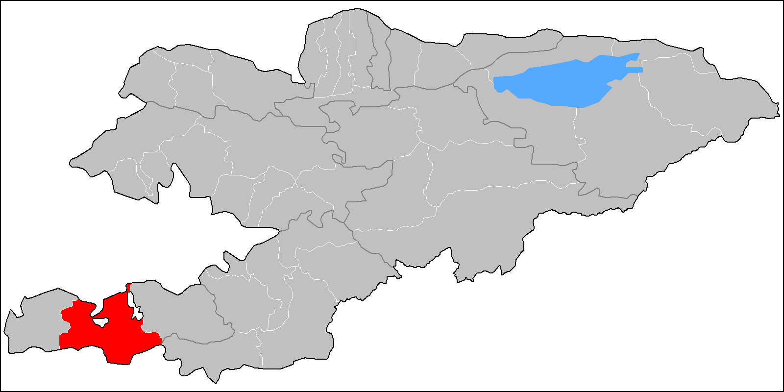
Vorukh (Russian language, Russian and Tajik language, Tajik: ąÆąŠčĆčāčģ; sog, W─ür┼Źx) is a Jamoats of Tajikistan, jamoat in northern Tajikistan. It is an exclave surrounded by Kyrgyzstan that forms part of the city of Isfara in Sughd Region. , the jamoat had a total population of 30,506.Jamoat-level basic indicators United Nations Development Programme in Tajikistan, accessed 3 October 2020 History and territorial conflicts  Vorukh is the name of a village and one of two exclaves of Tajikistan within the Batken Province of Kyrgyzstan. There are three Tajik enclave ...
[...More Info...] [...Related Items...] OR: [Wikipedia] [Google] [Baidu] |
Kyrgyzstan
Kyrgyzstan,, pronounced or the Kyrgyz Republic, is a landlocked country in Central Asia. Kyrgyzstan is bordered by Kazakhstan to the north, Uzbekistan to the west, Tajikistan to the south, and the People's Republic of China to the east. Its capital and largest city is Bishkek. Ethnic Kyrgyz make up the majority of the country's seven million people, followed by significant minorities of Uzbeks and Russians. The Kyrgyz language is closely related to other Turkic languages. Kyrgyzstan's history spans a variety of cultures and empires. Although geographically isolated by its highly mountainous terrain, Kyrgyzstan has been at the crossroads of several great civilizations as part of the Silk Road along with other commercial routes. Inhabited by a succession of tribes and clans, Kyrgyzstan has periodically fallen under larger domination. Turkic nomads, who trace their ancestry to many Turkic states. It was first established as the Yenisei Kyrgyz Khaganate later in the ... [...More Info...] [...Related Items...] OR: [Wikipedia] [Google] [Baidu] |
Batken Province
Batken Region ( ky, ąæą░čéą║ąĄąĮ ąŠą▒ą╗čāčüčā, Batken oblusu; russian: ąæą░čéą║ąĄąĮčüą║ą░čÅ ąŠą▒ą╗ą░čüčéčī, Batkenskaya oblast) is a region ('' oblus'') of Kyrgyzstan. Its capital is Batken. It is bounded on the east by Osh Region, on the south, west and north by Tajikistan, and on the northeast by Uzbekistan. The northern part of the region is part of the flat, agricultural Ferghana Valley. The land rises southward to the mountains on the southern border: the Alay Mountains in the east, and the Turkestan Range in the west. Its total area is . The resident population of the region was 548,247 as of January 2021. The region has sizeable Uzbek (14.7% in 2009) and Tajik (6.9% in 2009) minorities. History Batken Region was created on 15 October 1999 from the westernmost section of Osh Region. This was partly in response to the activities of the Islamic Movement for Uzbekistan (IMU), with bases in Tajikistan. In 1999 they kidnapped a group of Japanese geologists and in 2000 some Amer ... [...More Info...] [...Related Items...] OR: [Wikipedia] [Google] [Baidu] |
Jamoats Of Tajikistan
The jamoats of Tajikistan (russian: ą┤ąČą░ą╝ąŠą░čéčŗ, dzhamoaty; tg, ęĘą░ą╝ąŠą░čéąĖ ą┤ąĄę│ąŠčé, jamoati dehot, "village communes") are the third-level administrative divisions, similar to communes or municipalities, in the Central Asian country of Tajikistan. As of January 2020, there are 368 rural jamoats, 65 urban-type settlement, towns and 18 cities in Tajikistan. Each jamoat is further subdivided into villages (or ''deha'' or ''qyshqol'') The jamoats and towns, and their population figures (as of January 2015) by district of each region are listed below:Jamoat-level basic indicators United Nations Development Programme in Tajikistan, accessed 2 October 2020 Sughd Region Districts of Republican Subordination Khatlon Region ...[...More Info...] [...Related Items...] OR: [Wikipedia] [Google] [Baidu] |
Shohimardon
Shohimardon (also ''Shakhimardan'', uz, Shohimardon / ą©ąŠę│ąĖą╝ą░čĆą┤ąŠąĮ, russian: ą©ą░čģąĖą╝ą░čĆą┤ą░ąĮ, Shakhimardan) is a village and a subdivision (rural community) of Fergana District, Fergana Region in eastern Uzbekistan. It is an exclave of Uzbekistan, surrounded by Kyrgyzstan, in a valley in the Pamiro-Alai mountains. The river Shohimardonsoy flows through the exclave. There are two villages: Shohimardon and Yordon. Shohimardon is a popular resort with several sanatoriums, and an active place of pilgrimage. According to one folk legend, the Caliph Ali was buried in Shohimardon. Shakhimardan City Resort is situated at 1975m above sea level, 155 km from Ferghana, in the picturesque mountainous district. The Kuliqurbon or Blue Lake is seven kilometers southeast of Shakhimardan. It was formed in 1766 after a series of extreme earthquakes. The lake is located at an altitude of 1,724 metres. It's 170 m long, 60 m tall, 5ŌĆō10 m deep. The cableway continues to the lak ... [...More Info...] [...Related Items...] OR: [Wikipedia] [Google] [Baidu] |
Kayragach
Lolazor ( tg, ąøąŠą╗ą░ąĘąŠčĆ, , formerly ęÜą░ą╣čĆą░ęōąŠčć ''Kayraghoch'' or ''Kayragach''; also known as "Western Qal'acha") is a small exclave of Tajikistan, which is just across the international border inside Kyrgyzstan. Situated 7 km south of Mehrobod (formerly Proletarsk, Tajikistan) and 14 km north of Sulukta (Kyrgyzstan), it is completely surrounded by the Leilek District of Batken Region, Kyrgyzstan. It is near the railway station of ''Stantsiya Kayragach'', on the line from Proletarsk to Sulukta. It is part of the jamoat Gulkhona in Jabbor Rasulov District.Village Lolazor tojkiston.ucoz.ru See also * Sarvan, the Tajikistan exclave in Uzbekistan * |
Isfara
Isfara ( tg, ąśčüčäą░čĆą░ fa, ž¦ž│┘üž▒┘ć; russian: ąśčüčäą░čĆą░) is a city in Sughd Region in northern Tajikistan, situated on the border with Kyrgyzstan. The city was the seat of the former Isfara District. There are currently territorial disputes between Tajikistan and Kyrgyzstan over the area of Isfara Valley. History The first author who mentions Esfara as a town, is B─übor. He praised the orchards and fruits of Isfara, especially its almonds. The 16th century saw the construction of large public buildings, notably mosques and medreseh. In the 18th century Isfara was the seat of the Khan of ßĖ┤oqand whose wars with Bokhara resulted in the destruction of some historical monuments. Around 20 km south, in the village of Chorku, the mausoleum Hazrati Shoh Mausoleum, is carved from wood, partly dating back to the 8th century, a structure that is unique in Central Asia. Demographics The population of Isfara is mostly Tajik. Geography Isfara is situated near the bord ... [...More Info...] [...Related Items...] OR: [Wikipedia] [Google] [Baidu] |
List Of Enclaves And Exclaves
In political geography, an enclave is a piece of land belonging to one country (or region etc.) that is totally surrounded by another country (or region). An exclave is a piece of land that is politically attached to a larger piece but not physically contiguous with it (connected to it) because they are completely separated by a surrounding foreign territory or territories. Many entities are both enclaves and exclaves. Enclaves that are also exclaves Each enclave listed in this section has an administrative level equivalent to that of the one other entity that entirely surrounds it. Each enclave is also a part of a main region; hence, it is an exclave of that region. National level First-order subnational level Other subnational * In Australia: ** The larger of the two parts of the Aboriginal Shire of Doomadgee in Queensland is surrounded by the Shire of Burke. Except for the ocean, the smaller part is nearly surrounded also by the Shire of Burke. * In China: ** Chaoy ... [...More Info...] [...Related Items...] OR: [Wikipedia] [Google] [Baidu] |
Jamoats Of Tajikistan
The jamoats of Tajikistan (russian: ą┤ąČą░ą╝ąŠą░čéčŗ, dzhamoaty; tg, ęĘą░ą╝ąŠą░čéąĖ ą┤ąĄę│ąŠčé, jamoati dehot, "village communes") are the third-level administrative divisions, similar to communes or municipalities, in the Central Asian country of Tajikistan. As of January 2020, there are 368 rural jamoats, 65 urban-type settlement, towns and 18 cities in Tajikistan. Each jamoat is further subdivided into villages (or ''deha'' or ''qyshqol'') The jamoats and towns, and their population figures (as of January 2015) by district of each region are listed below:Jamoat-level basic indicators United Nations Development Programme in Tajikistan, accessed 2 October 2020 Sughd Region Districts of Republican Subordination Khatlon Region ...[...More Info...] [...Related Items...] OR: [Wikipedia] [Google] [Baidu] |
Sarvan, Tajikistan
Sarvan (or Sarvak, Sarvaksoi and Sarvaki-bolo) is a Tajik enclave of the Sughd Region surrounded by Uzbekistan. It is located in the Fergana region where Kyrgyzstan, Tajikistan and Uzbekistan meet. Sarvan is located 1.4 km from the Tajik-Uzbek border. Sarvan covers a valley with an area of about 8 km┬▓ and has a population of around 150 people. The principal economic activity is agriculture. History and territorial conflicts Due to inherent territorial restrictions, violent conflicts over land ownership, access to pasture, and shared water resources have become more common, as logistical complications within this densely populated and impoverished region have also given rise to economic concern. The Uzbek-Tajik border near Sarvan was closed in 2004 following terrorist attacks in Tashkent. References {{Reflist See also *Vorukh, a Tajikistan exclave in Kyrgyzstan * Kayragach, a Tajikistan exclave in Kyrgyzstan *Shohimardon Shohimardon (also ''Shakhimardan'', uz, Sh ... [...More Info...] [...Related Items...] OR: [Wikipedia] [Google] [Baidu] |
Continental Climate
Continental climates often have a significant annual variation in temperature (warm summers and cold winters). They tend to occur in the middle latitudes (40 to 55 north), within large landmasses where prevailing winds blow overland bringing some precipitation, and temperatures are not moderated by oceans. Continental climates occur mostly in the Northern Hemisphere due to the large landmasses found there. Most of northern and northeastern China, eastern and southeastern Europe, Western and north western Iran, central and southeastern Canada, and the central and northeastern United States have this type of climate. Continentality is a measure of the degree to which a region experiences this type of climate. In continental climates, precipitation tends to be moderate in amount, concentrated mostly in the warmer months. Only a few areasŌĆöin the mountains of the Pacific Northwest of North America and in Iran, northern Iraq, adjacent Turkey, Afghanistan, Pakistan, and Central AsiaŌĆ ... [...More Info...] [...Related Items...] OR: [Wikipedia] [Google] [Baidu] |

.jpg)


