Voreppe
   HOME
*


Voreppe
Voreppe () is a commune in the Isère department in southeastern France. It is part of the Grenoble urban unit (agglomeration).Unité urbaine 2020 de Grenoble (38701)
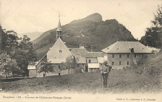
INSEE The commune contains the Monastère de Chalais, a Dominican about from the town of Voreppe.


Population


Twin towns

Voreppe is with: *
[...More Info...]      
[...Related Items...]     OR:     [Wikipedia]   [Google]   [Baidu]  


picture info

Monastère De Chalais
The Monastère de Chalais, also called Châlais-sur-Voreppe or Notre-Dame de Châlais, is a Dominican convent near the town of Voreppe, Isère, France. The convent dates from 1101. The monastery at Chalais began as a house of male hermits, under the guidance of S Hugh of Chateauneuf, like the Carthusian monks. At first the Order of Chalais was independent, but in 1303 it was absorbed by the Carthusians. The monastery was partly destroyed in 1562 during French Wars of Religion, but was rebuilt. The state seized it during the French Revolution (1789–99) and sold it to a private owner. From 1844 to 1887 it was again a monastery, this time of the Dominican friars, before again being sold. The present community of Dominican nuns bought the property in 1963 and restored it. Today the nuns of Chalais manufacture Monastic biscuits to cover their expenses. Location The monastery is about from Voreppe along a winding forest road. It is located on a plateau overlooking Voreppe at an ...
[...More Info...]      
[...Related Items...]     OR:     [Wikipedia]   [Google]   [Baidu]  


Communauté D'agglomération Du Pays Voironnais
The Communauté d'agglomération du Pays Voironnais is the ''communauté d'agglomération'', an intercommunal structure, centred on the town of Voiron. It is located in the Isère department, in the Auvergne-Rhône-Alpes region, eastern France. It was created in 2000.CA du Pays Voironnais (N° SIREN : 243800984)
BANATIC, accessed 7 April 2022.
Its area is 367.3 km2. Its population was 93,573 in 2018, of which 20,248 in Voiron proper.Comparateur de territoire
INSEE, accessed 7 April 2022.


Composition

The communauté d'agglomér ...
[...More Info...]      
[...Related Items...]     OR:     [Wikipedia]   [Google]   [Baidu]  


Grenoble Urban Unit
The urban unit of Grenoble (french: unité urbaine de Grenoble) is a French urban unit centred on the city of Grenoble lat, Gratianopolis , commune status = Prefecture and commune , image = Panorama grenoble.png , image size = , caption = From upper left: Panorama of the city, Grenoble’s cable cars, place Saint- .... An urban unit is a contiguously built-up area with at least 2,000 inhabitants, according to the definition by the French statistics institute INSEE. In the current zoning, revised in 2020, it consists of 38 communes.Unité urbaine 2020 de Grenoble (38701)
INSEE
It covers 358.1 km2 and has 451,096 inhabitants (2018), population density 1260 /km2.
[...More Info...]      
[...Related Items...]     OR:     [Wikipedia]   [Google]   [Baidu]  


Lichtenstein, Baden-Württemberg
Lichtenstein is a municipality in the Tübingen administrative region in Baden-Württemberg, Germany. It lies at the foot of the Swabian Jura (plateau). History The municipality of Lichtenstein was created on 1 January 1975 by the merger of Honau, , and Unterhausen (which had in 1930 merged with Oberhausen). By the agreement made before this merger, Unterhausen changed its name to Lichtenstein, after the famous Lichtenstein Castle above the town. The towns of the municipality expanded substantially from 1975 to 1990 thanks to tourism. Lichtenstein expanded the most, first purchasing an old industrial site in 1979 to turn it into a new town center. Geography The municipality (''Gemeinde'') of Lichtenstein covers of the Reutlingen district, in the state of the Federal Republic of Germany. It is physically located in the middle of the Swabian Jura, on the edge of the in the valley of the river Echaz. Elevation above sea level ranges from to Normalnull. The , , and Federally ...
[...More Info...]      
[...Related Items...]     OR:     [Wikipedia]   [Google]   [Baidu]  


picture info

Castelnovo Ne' Monti
Castelnovo Monti (officially Castelnovo ne' Monti; locally ) is a town and '' comune'' in the province of Reggio Emilia, central Italy. Along with every other town and village in the Apennines, Castelnovo is an approved area for the production of Parmesan cheese. It is also home to the only hospital in the area. Geography It is situated in the Reggiano Apennines mountains. Castelnovo is best known for the Pietra di Bismantova spur. The pietra (literally "Rock of Bismantova") can be spotted from a distance of as it stands at around above sea level. The rock is a favourite climbing and abseiling destination throughout Italy and is considered a particularly difficult climb due to its outward-curving wall. The rock was mentioned by the Italian poet Dante Alighieri in the ''Divine Comedy''. Other geographical landmarks include the Triassic chalk formations of the ''Gessi Triassici'' and the river Secchia which, together with the Pietra of Bismantova, are part of the Nationa ...
[...More Info...]      
[...Related Items...]     OR:     [Wikipedia]   [Google]   [Baidu]  


Communes Of The Isère Department
The following is a list of the 512 communes in the French department of Isère. The communes cooperate in the following intercommunalities (as of 2020):BANATIC
Périmètre des EPCI à fiscalité propre. Accessed 3 July 2020.
* * *

picture info

Communes Of France
The () is a level of administrative division in the French Republic. French are analogous to civil townships and incorporated municipalities in the United States and Canada, ' in Germany, ' in Italy, or ' in Spain. The United Kingdom's equivalent are civil parishes, although some areas, particularly urban areas, are unparished. are based on historical geographic communities or villages and are vested with significant powers to manage the populations and land of the geographic area covered. The are the fourth-level administrative divisions of France. vary widely in size and area, from large sprawling cities with millions of inhabitants like Paris, to small hamlets with only a handful of inhabitants. typically are based on pre-existing villages and facilitate local governance. All have names, but not all named geographic areas or groups of people residing together are ( or ), the difference residing in the lack of administrative powers. Except for the municipal arr ...
[...More Info...]      
[...Related Items...]     OR:     [Wikipedia]   [Google]   [Baidu]  


picture info

Isère
Isère ( , ; frp, Isera; oc, Isèra, ) is a landlocked department in the southeastern French region of Auvergne-Rhône-Alpes. Named after the river Isère, it had a population of 1,271,166 in 2019.Populations légales 2019: 38 Isère
INSEE
Its is Grenoble. It borders Rhône to the northwest, Ain to the north,

picture info

Departments Of France
In the administrative divisions of France, the department (french: département, ) is one of the three levels of government under the national level ("territorial collectivities"), between the administrative regions and the communes. Ninety-six departments are in metropolitan France, and five are overseas departments, which are also classified as overseas regions. Departments are further subdivided into 332 arrondissements, and these are divided into cantons. The last two levels of government have no autonomy; they are the basis of local organisation of police, fire departments and, sometimes, administration of elections. Each department is administered by an elected body called a departmental council ( ing. lur.. From 1800 to April 2015, these were called general councils ( ing. lur.. Each council has a president. Their main areas of responsibility include the management of a number of social and welfare allowances, of junior high school () buildings and technical ...
[...More Info...]      
[...Related Items...]     OR:     [Wikipedia]   [Google]   [Baidu]  


picture info

France
France (), officially the French Republic ( ), is a country primarily located in Western Europe. It also comprises of overseas regions and territories in the Americas and the Atlantic, Pacific and Indian Oceans. Its metropolitan area extends from the Rhine to the Atlantic Ocean and from the Mediterranean Sea to the English Channel and the North Sea; overseas territories include French Guiana in South America, Saint Pierre and Miquelon in the North Atlantic, the French West Indies, and many islands in Oceania and the Indian Ocean. Due to its several coastal territories, France has the largest exclusive economic zone in the world. France borders Belgium, Luxembourg, Germany, Switzerland, Monaco, Italy, Andorra, and Spain in continental Europe, as well as the Netherlands, Suriname, and Brazil in the Americas via its overseas territories in French Guiana and Saint Martin. Its eighteen integral regions (five of which are overseas) span a combined area of ...
[...More Info...]      
[...Related Items...]     OR:     [Wikipedia]   [Google]   [Baidu]  


picture info

Monastery
A monastery is a building or complex of buildings comprising the domestic quarters and workplaces of monastics, monks or nuns, whether living in communities or alone ( hermits). A monastery generally includes a place reserved for prayer which may be a chapel, church, or temple, and may also serve as an oratory, or in the case of communities anything from a single building housing only one senior and two or three junior monks or nuns, to vast complexes and estates housing tens or hundreds. A monastery complex typically comprises a number of buildings which include a church, dormitory, cloister, refectory, library, balneary and infirmary, and outlying granges. Depending on the location, the monastic order and the occupation of its inhabitants, the complex may also include a wide range of buildings that facilitate self-sufficiency and service to the community. These may include a hospice, a school, and a range of agricultural and manufacturing buildings such as a barn, a ...
[...More Info...]      
[...Related Items...]     OR:     [Wikipedia]   [Google]   [Baidu]  


picture info

Town Twinning
A sister city or a twin town relationship is International relations, a form of legal or social agreement between two geographically and politically distinct localities for the purpose of promoting cultural and commercial ties. While there are early examples of international links between municipalities akin to what are known as sister cities or twin towns today dating back to the 9th century, the modern concept was first established and adopted worldwide during World War II. Origins of the modern concept The modern concept of town twinning has its roots in the Second World War. More specifically, it was inspired by the bombing of Coventry on 14 November 1940, known as the Coventry Blitz. First conceived by the then Mayor of Coventry, Alfred Robert Grindlay, culminating in his renowned telegram to the people of Stalingrad (now Volgograd) in 1942, the idea emerged as a way of establishing solidarity links between cities in allied countries that went through similar devastating e ...
[...More Info...]      
[...Related Items...]     OR:     [Wikipedia]   [Google]   [Baidu]