|
Volochanka
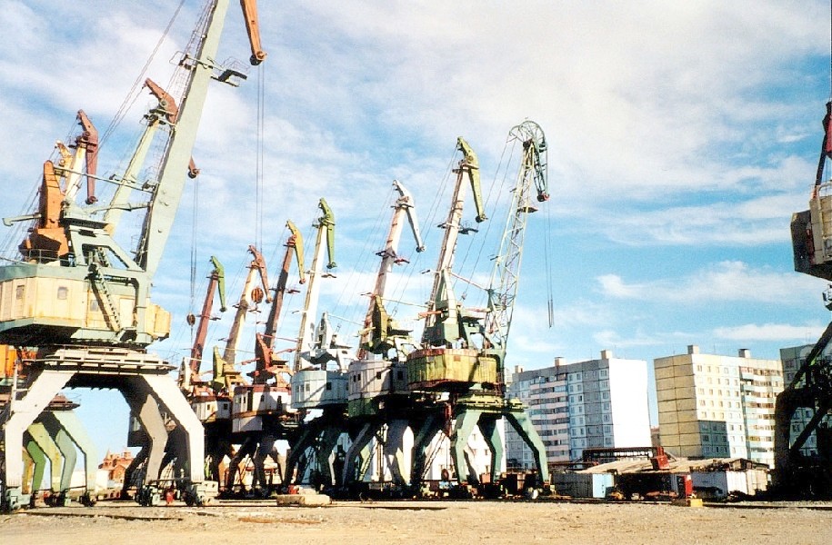
Volochanka (russian: Волочанка) is a rural locality (a settlement) under the administrative jurisdiction of the district town of Dudinka in Taymyrsky Dolgano-Nenetsky District of Krasnoyarsk Krai, Russia. It is located on the Kheta River in the Taymyr Peninsula. Population: 530 people (2010 est.).Территориальный орган федеральной службы государственной статистики по Красноярскому краюВолочанка(xls) History In 1932, native leaders of three nationalities, including the Dolgan and Yakuts, started a civil uprising in Volochanka against the Bolsheviks; twenty Party workers were killed and many others wounded in the event. Demographics The inhabitants include representatives of Taymyr, Dolgans Dolgans (; Dolgan: , , (Sakha); Yakut: ) are an ethnic group who mostly inhabit Krasnoyarsk Krai, Russia. They are descended from several groups, particularly Evenks, one of the indigenous ... [...More Info...] [...Related Items...] OR: [Wikipedia] [Google] [Baidu] |
Nganasan People
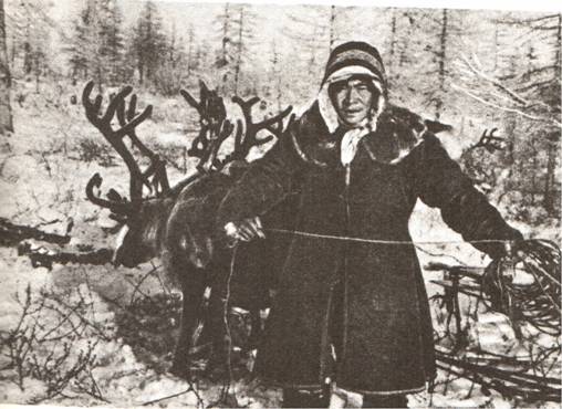
The Nganasans (; Nganasan: ''ŋənəhsa(nəh)'', ''ńæh'') are a Uralic people of the Samoyedic branch native to the Taymyr Peninsula in north Siberia. In the Russian Federation, they are recognized as one of the indigenous peoples of the Russian North. They reside primarily in the settlements of Ust-Avam, Volochanka, and Novaya in the Taymyrsky Dolgano-Nenetsky District of Krasnoyarsk Krai, with smaller populations residing in the towns of Dudinka and Norilsk as well. The Nganasans are thought to be the direct descendants of proto-Uralic peoples. However there is some evidence that they absorbed local Paleo-Siberian population. The Nganasans were traditionally a semi-nomadic people whose main form of subsistence was wild reindeer hunting, in contrast to the Nenets, who herded reindeer. Beginning in the early 17th century, the Nganasans were subjected to the yasak system of Czarist Russia. They lived relatively independently, until the 1970s, when they were settled in the ... [...More Info...] [...Related Items...] OR: [Wikipedia] [Google] [Baidu] |
Krasnoyarsk Krai
Krasnoyarsk Krai ( rus, Красноя́рский край, r=Krasnoyarskiy kray, p=krəsnɐˈjarskʲɪj ˈkraj) is a federal subject of Russia (a krai), with its administrative center in the city of Krasnoyarsk, the third-largest city in Siberia (after Novosibirsk and Omsk). Comprising half of the Siberian Federal District, Krasnoyarsk Krai is the largest krai in the Russian Federation, the second largest federal subject (after neighboring Sakha) and the third largest subnational governing body by area in the world, after Sakha and the Australian state of Western Australia. The krai covers an area of , which is nearly one quarter the size of the entire country of Canada (the next-largest country in the world after Russia), constituting roughly 13% of the Russian Federation's total area and containing a population of 2,828,187 (more than a third of them in the city of Krasnoyarsk), or just under 2% of its population, per the 2010 Census. Geography The krai lies in the middl ... [...More Info...] [...Related Items...] OR: [Wikipedia] [Google] [Baidu] |
Taymyrsky Dolgano-Nenetsky District
Taymyrsky Dolgano-Nenetsky District (russian: Таймы́рский Долга́но-Не́нецкий райо́н) is an administrativeLaw #10-4765 and municipalLaw #2-54 district (raion), one of the forty-three in Krasnoyarsk Krai, Russia. It is located in the north of the krai above the Arctic Circle on the Taymyr Peninsula and borders with Laptev and Kara Seas in the north, the Sakha Republic in the east, Evenkiysky and Turukhansky Districts in the south, and with Yamalo-Nenets Autonomous Okrug in the west. The area of the district is .Official website of Krasnoyarsk KraiInformation about Taymyrsky Dolgano-Nenetsky District Its administrative center is the town of Dudinka, which accounts for 64.4% of the district's total population. The 2010 Russian census counted 34,432 people in the whole district, as opposed to 39,786 ( 2002 Census) in 2002, and in 1989. Norilsk is an enclave surrounded by, but independent from, Taymyrsky Dolgano-Nenetsky District. In 2005, the c ... [...More Info...] [...Related Items...] OR: [Wikipedia] [Google] [Baidu] |
Dudinka
Dudinka (russian: Дуди́нка; Nenets: Тут'ын, ''Tutꜧyn'') is a town on the Yenisei River and the administrative center of Taymyrsky Dolgano-Nenetsky District of Krasnoyarsk Krai, Russia. It used to be the administrative center of Taymyr Autonomous Okrug, which was merged into Krasnoyarsk Krai on January 1, 2007. Population: History It was founded in 1667 as a winter settlement connected to Mangazeya. In 1930 it was designated the administrative center of the Taimyr Dolgan-Nenets National Region. In 1935, the polar explorer Otto Schmidt recommended that the settlement be expanded into a town. By 1937, the port facilities and a railroad to Norilsk were completed. Town status was granted in 1951. Administrative and municipal status Within the framework of administrative divisions, Dudinka serves as the administrative center of Taymyrsky Dolgano-Nenetsky District.Law #10-4765 As an administrative division, it is, together with five rural localities, incorporated ... [...More Info...] [...Related Items...] OR: [Wikipedia] [Google] [Baidu] |
Town Of District Significance
Town of district significance is an administrative division of a district in a federal subject of Russia. It is equal in status to a selsoviet or an urban-type settlement of district significance, but is organized around a town (as opposed to a rural locality or an urban-type settlement); often with surrounding rural territories. Background Prior to the adoption of the 1993 Constitution of Russia, this type of administrative division was defined on the whole territory of the Russian SFSR as an inhabited locality which serves as a cultural and an industrial center of a district and has a population of at least 12,000, of which at least 80% are workers, public servants, and the members of their families.Иванец Г.И., Калинский И.В., Червонюк В.И. Конституционное право России: энциклопедический словарь / Под общей ред. В.И. Червонюка. — М.: Юрид. лит., 2002. — 43 ... [...More Info...] [...Related Items...] OR: [Wikipedia] [Google] [Baidu] |
Types Of Inhabited Localities In Russia
The classification system of inhabited localities in Russia and some other post-Soviet states has certain peculiarities compared with those in other countries. Classes During the Soviet time, each of the republics of the Soviet Union, including the Russian SFSR, had its own legislative documents dealing with classification of inhabited localities. After the dissolution of the Soviet Union, the task of developing and maintaining such classification in Russia was delegated to the federal subjects.Articles 71 and 72 of the Constitution of Russia do not name issues of the administrative and territorial structure among the tasks handled on the federal level or jointly with the governments of the federal subjects. As such, all federal subjects pass their own laws establishing the system of the administrative-territorial divisions on their territories. While currently there are certain peculiarities to classifications used in many federal subjects, they are all still largely ba ... [...More Info...] [...Related Items...] OR: [Wikipedia] [Google] [Baidu] |
Town Of District Significance
Town of district significance is an administrative division of a district in a federal subject of Russia. It is equal in status to a selsoviet or an urban-type settlement of district significance, but is organized around a town (as opposed to a rural locality or an urban-type settlement); often with surrounding rural territories. Background Prior to the adoption of the 1993 Constitution of Russia, this type of administrative division was defined on the whole territory of the Russian SFSR as an inhabited locality which serves as a cultural and an industrial center of a district and has a population of at least 12,000, of which at least 80% are workers, public servants, and the members of their families.Иванец Г.И., Калинский И.В., Червонюк В.И. Конституционное право России: энциклопедический словарь / Под общей ред. В.И. Червонюка. — М.: Юрид. лит., 2002. — 43 ... [...More Info...] [...Related Items...] OR: [Wikipedia] [Google] [Baidu] |
Russia
Russia (, , ), or the Russian Federation, is a List of transcontinental countries, transcontinental country spanning Eastern Europe and North Asia, Northern Asia. It is the List of countries and dependencies by area, largest country in the world, with its internationally recognised territory covering , and encompassing one-eighth of Earth's inhabitable landmass. Russia extends across Time in Russia, eleven time zones and shares Borders of Russia, land boundaries with fourteen countries, more than List of countries and territories by land borders, any other country but China. It is the List of countries and dependencies by population, world's ninth-most populous country and List of European countries by population, Europe's most populous country, with a population of 146 million people. The country's capital and List of cities and towns in Russia by population, largest city is Moscow, the List of European cities by population within city limits, largest city entirely within E ... [...More Info...] [...Related Items...] OR: [Wikipedia] [Google] [Baidu] |
Kheta River
The Kheta (russian: Хета) is a river in Krasnoyarsk Krai in Russia, left composite of the Khatanga River. The river is long. The area of its drainage basin is . Course The Kheta is formed by the confluence of the Ayan and Ayakli, both of which originate in the Putorana Plateau. The Kheta freezes up in late September or early October and breaks up in late May or the first half of June. Its main tributaries are the Boyarka, Maymecha, and Boganida. See also *List of rivers of Russia
Russi ...
[...More Info...] [...Related Items...] OR: [Wikipedia] [Google] [Baidu] |
Taymyr Peninsula
The Taymyr Peninsula (russian: Таймырский полуостров, Taymyrsky poluostrov) is a peninsula in the Far North of Russia, in the Siberian Federal District, that forms the northernmost part of the mainland of Eurasia. Administratively it is part of the Krasnoyarsk Krai Federal subject of Russia. Geography The Taymyr Peninsula lies between the Yenisei Gulf of the Kara Sea and the Khatanga Gulf of the Laptev Sea. Lake Taymyr and the Byrranga Mountains are located within the vast Taymyr Peninsula. Cape Chelyuskin, the northernmost point of the Afro-Eurasian continent, is located at the northern end of the Taymyr Peninsula. Population The Nenets people, also known as ''Samoyeds'', are an indigenous people in northern arctic Russia, and some live at the Taymyr Peninsula. The Nganasan people are an indigenous Samoyedic people inhabiting central Siberia, including the Taymyr Peninsula. In the Russian Federation, they are recognized as being one of the Indigenous ... [...More Info...] [...Related Items...] OR: [Wikipedia] [Google] [Baidu] |
Dolgans
Dolgans (; Dolgan: , , (Sakha); Yakut: ) are an ethnic group who mostly inhabit Krasnoyarsk Krai, Russia. They are descended from several groups, particularly Evenks, one of the indigenous peoples of the Russian North. They adopted a Turkic language sometime after the 18th century. The 2010 Census counted 7,885 Dolgans. This number includes 5,517 in former Taymyr Autonomous Okrug. Dolgans speak the Dolgan language, which is closely related to the Yakut language. History In the 17th century, the Dolgans lived in the basins of the Olenyok River and Lena River. They moved to their current location, Taymyr, in the 18th century. The Dolgan identity began to emerge during the 19th and early 20th centuries, under the influence of three groups who migrated to the Krasnoyarsk area from the Lena River and Olenyok River region: Evenks, Yakuts, Enets, and so-called tundra peasants (). Culture and livelihood Originally, the Dolgans were nomadic hunters and reindeer herders. How ... [...More Info...] [...Related Items...] OR: [Wikipedia] [Google] [Baidu] |
Rural Localities In Krasnoyarsk Krai
In general, a rural area or a countryside is a geographic area that is located outside towns and cities. Typical rural areas have a low population density and small settlements. Agricultural areas and areas with forestry typically are described as rural. Different countries have varying definitions of ''rural'' for statistical and administrative purposes. In rural areas, because of their unique economic and social dynamics, and relationship to land-based industry such as agriculture, forestry and resource extraction, the economics are very different from cities and can be subject to boom and bust cycles and vulnerability to extreme weather or natural disasters, such as droughts. These dynamics alongside larger economic forces encouraging to urbanization have led to significant demographic declines, called rural flight, where economic incentives encourage younger populations to go to cities for education and access to jobs, leaving older, less educated and less wealthy popul ... [...More Info...] [...Related Items...] OR: [Wikipedia] [Google] [Baidu] |
.jpg)


.jpg)

