|
Vitim River
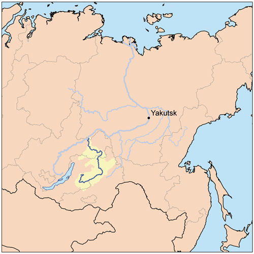
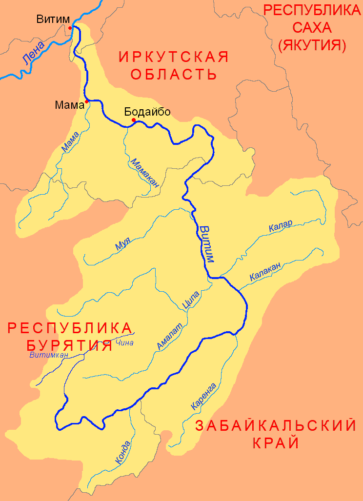
The Vitim (russian: Витим; evn, Витым, ; sah, Виитим, ; Buryat and mn, Витим, ''Vitim'') is a major tributary of the Lena. Its source is east of Lake Baikal, at the confluence of rivers Vitimkan from the west and China from the east. The Vitim flows first south, bends eastwards and then northward in the Vitim Plateau. Then it flows north through the Stanovoy Highlands and the town of Bodaybo. Including river Vitimkan, its western source, it is long, and has a drainage basin of .Витим (река в Бурят. АССР) It is navigable from the Lena to Bodaybo. Upstream, ... [...More Info...] [...Related Items...] OR: [Wikipedia] [Google] [Baidu] |
Russia
Russia (, , ), or the Russian Federation, is a List of transcontinental countries, transcontinental country spanning Eastern Europe and North Asia, Northern Asia. It is the List of countries and dependencies by area, largest country in the world, with its internationally recognised territory covering , and encompassing one-eighth of Earth's inhabitable landmass. Russia extends across Time in Russia, eleven time zones and shares Borders of Russia, land boundaries with fourteen countries, more than List of countries and territories by land borders, any other country but China. It is the List of countries and dependencies by population, world's ninth-most populous country and List of European countries by population, Europe's most populous country, with a population of 146 million people. The country's capital and List of cities and towns in Russia by population, largest city is Moscow, the List of European cities by population within city limits, largest city entirely within E ... [...More Info...] [...Related Items...] OR: [Wikipedia] [Google] [Baidu] |
Kalar (river)
The Kalar (russian: Калар), known as the Levoy Chinoy in its upper section, is a river in Zabaykalsky Krai, southern East Siberia, Russia. It is long, and has a drainage basin of . The area through which the river flows is mountainous in most of its length with frequent rapids in the riverbed.Google Earth The waters are rich in fish, including grayling, lenok, taimen and whitefish, among other species. In the International scale of river difficulty the Kalar is a Class III - IV destination for rafting and kayaking. The Kalar has lent its name to a number of other geographic features, including the Kalar Range, the local Kalar District, as well as Sredny Kalar (Middle Kalar) village by its right bank from its mouth. Course The Kalar is a right tributary of the Vitim. Its sources are between the Udokan Range and the Kalar Range subranges of the Stanovoy Highlands. In its upper course it cuts eastwards across the Kalar Range in a wide arc as the Levoy Chinoy. The river ... [...More Info...] [...Related Items...] OR: [Wikipedia] [Google] [Baidu] |
Insects
Insects (from Latin ') are pancrustacean hexapod invertebrates of the class Insecta. They are the largest group within the arthropod phylum. Insects have a chitinous exoskeleton, a three-part body (head, thorax and abdomen), three pairs of jointed legs, compound eyes and one pair of antennae. Their blood is not totally contained in vessels; some circulates in an open cavity known as the haemocoel. Insects are the most diverse group of animals; they include more than a million described species and represent more than half of all known living organisms. The total number of extant species is estimated at between six and ten million; In: potentially over 90% of the animal life forms on Earth are insects. Insects may be found in nearly all environments, although only a small number of species reside in the oceans, which are dominated by another arthropod group, crustaceans, which recent research has indicated insects are nested within. Nearly all insects hatch from eggs. Inse ... [...More Info...] [...Related Items...] OR: [Wikipedia] [Google] [Baidu] |
Fossil
A fossil (from Classical Latin , ) is any preserved remains, impression, or trace of any once-living thing from a past geological age. Examples include bones, shells, exoskeletons, stone imprints of animals or microbes, objects preserved in amber, hair, petrified wood and DNA remnants. The totality of fossils is known as the ''fossil record''. Paleontology is the study of fossils: their age, method of formation, and evolutionary significance. Specimens are usually considered to be fossils if they are over 10,000 years old. The oldest fossils are around 3.48 billion years old to 4.1 billion years old. Early edition, published online before print. The observation in the 19th century that certain fossils were associated with certain rock strata led to the recognition of a geological timescale and the relative ages of different fossils. The development of radiometric dating techniques in the early 20th century allowed scientists to quantitatively measure the ... [...More Info...] [...Related Items...] OR: [Wikipedia] [Google] [Baidu] |
Baissa
The Zaza Formation is a geological formation located in Buryatia (Russia). It dates to the Lower Cretaceous period. It is Aptian in age and consists of sandstones, siltstones, marls and bituminous shales, deposited in a stratified lake. It is situated on a large granite plateau in the NE of Buryatia.Zherikhin, V.V., Mostovski, M.B., Vrsansky, P., Blagoderov, V.A. and Lukashevich, E.D. 1999The unique Lower Cretaceous locality of Baissa and other contemporaneous insect-bearing sites in North and West Transbaikalia ''Proceedings of the First Palaeoentomological Conference, Moscow, 1998''. Bratislava: Amba Projects, pp. 185-192. The formation is known for its numerous compression fossils of many varieties of insect found predominantly at the Baissa locality, located on the banks of the Vitim River. Insects are found in multiple beds throughout the succession, predominantly in the finer grained facies, the preservation of insect fossils is variable between beds, with good preservation ... [...More Info...] [...Related Items...] OR: [Wikipedia] [Google] [Baidu] |
Baikal Amur Mainline
Lake Baikal (, russian: Oзеро Байкал, Ozero Baykal ); mn, Байгал нуур, Baigal nuur) is a rift lake in Russia. It is situated in southern Siberia, between the Federal subjects of Russia, federal subjects of Irkutsk Oblast, Irkutsk Oblasts of Russia, Oblast to the northwest and the Republic of Buryatia to the southeast. With of water, Lake Baikal is the world's List of lakes by volume, largest freshwater lake by volume, containing 22–23% of the world's fresh surface water, more than all of the North American Great Lakes combined. It is also the world's List of lakes by depth, deepest lake, with a maximum depth of , and the world's ancient lake, oldest lake, at 25–30 million years. At —slightly larger than Belgium—Lake Baikal is the world's List of lakes by area, seventh-largest lake by surface area. It is among the world's clearest lakes. Lake Baikal is home to thousands of species of Plant, plants and animals, many of them endemic to the region. ... [...More Info...] [...Related Items...] OR: [Wikipedia] [Google] [Baidu] |
Great Soviet Encyclopedia
The ''Great Soviet Encyclopedia'' (GSE; ) is one of the largest Russian-language encyclopedias, published in the Soviet Union from 1926 to 1990. After 2002, the encyclopedia's data was partially included into the later ''Bolshaya rossiyskaya entsiklopediya'' (or '' Great Russian Encyclopedia'') in an updated and revised form. The GSE claimed to be "the first Marxist–Leninist general-purpose encyclopedia". Origins The idea of the ''Great Soviet Encyclopedia'' emerged in 1923 on the initiative of Otto Schmidt, a member of the Russian Academy of Sciences. In early 1924 Schmidt worked with a group which included Mikhail Pokrovsky, (rector of the Institute of Red Professors), Nikolai Meshcheryakov (Former head of the Glavit, the State Administration of Publishing Affairs), Valery Bryusov (poet), Veniamin Kagan (mathematician) and Konstantin Kuzminsky to draw up a proposal which was agreed to in April 1924. Also involved was Anatoly Lunacharsky, People's Commissar of Education ... [...More Info...] [...Related Items...] OR: [Wikipedia] [Google] [Baidu] |
Stanovoy Highlands
The Stanovoy Highlands ( rus, Станово́е наго́рье) or Stanovoy Uplands is a mountain range in the Transbaikal region of Siberia, Russia. Geography The Stanovoy Highlands are a mountainous area between the Patom Highlands to the north and the Vitim Plateau to the south. To the northeast they border with the Olyokma-Chara Plateau —in the upper reaches of the Chara river. The ranges of the highlands stretch roughly in a WSW / ENE direction between the North Baikal Highlands in the west and the Olyokma River in the east. There are large intermontane basins, such as the Muya Depression and the Chara Depression at altitudes ranging between and . Subranges The system of the Stanovoy Highlands comprises a group of subranges, including the following:Oleg Leonidovič Kryžanovskij, ''A Checklist of the Ground-beetles of Russia and Adjacent Lands.'' p. 15 *Southern Muya Range (Южно-Муйский хребет), highest point Muisky Gigant Muisky Gigant (russian: ... [...More Info...] [...Related Items...] OR: [Wikipedia] [Google] [Baidu] |
Vitim Plateau
Vitim Plateau is a plateau in Buryatia and Zabaykalsky Krai, Russia. The plateau is sparsely populated, the main settlements are Romanovka and Bagdarin. An area of the plateau is an ancient volcanic field with a number of cinder cones and volcanoes, the last of which was active about 810,000 years before present. The P436 regional road connecting Ulan-Ude and Chita passes through Romanovka across the plateau. Geography The Vitim Plateau lies along the headwaters of the Vitim River, a tributary of the Lena between the Southern Muya Range to the north, the Ikat Range to the west, the Yablonoi Mountains to the south, and in the east with the lower reaches of the Kalakan River to the right bank of the lower reaches of the Karenga River (both Vitim tributaries) and the latter's right tributary, the Bugarikta. The Vitim River begins at the confluence of the China and Vitimkan rivers on the plateau and makes a wide bend around the volcanic zone before flowing northwards. Rive ... [...More Info...] [...Related Items...] OR: [Wikipedia] [Google] [Baidu] |
Lake Baikal
Lake Baikal (, russian: Oзеро Байкал, Ozero Baykal ); mn, Байгал нуур, Baigal nuur) is a rift lake in Russia. It is situated in southern Siberia, between the federal subjects of Irkutsk Oblast to the northwest and the Republic of Buryatia to the southeast. With of water, Lake Baikal is the world's largest freshwater lake by volume, containing 22–23% of the world's fresh surface water, more than all of the North American Great Lakes combined. It is also the world's deepest lake, with a maximum depth of , and the world's oldest lake, at 25–30 million years. At —slightly larger than Belgium—Lake Baikal is the world's seventh-largest lake by surface area. It is among the world's clearest lakes. Lake Baikal is home to thousands of species of plants and animals, many of them endemic to the region. It is also home to Buryat tribes, who raise goats, camels, cattle, sheep, and horses on the eastern side of the lake, where the mean temperature var ... [...More Info...] [...Related Items...] OR: [Wikipedia] [Google] [Baidu] |
Source (river Or Stream)
The headwaters of a river or stream is the farthest place in that river or stream from its estuary or downstream confluence with another river, as measured along the course of the river. It is also known as a river's source. Definition The United States Geological Survey (USGS) states that a river's "length may be considered to be the distance from the mouth to the most distant headwater source (irrespective of stream name), or from the mouth to the headwaters of the stream commonly known as the source stream". As an example of the second definition above, the USGS at times considers the Missouri River as a tributary of the Mississippi River. But it also follows the first definition above (along with virtually all other geographic authorities and publications) in using the combined Missouri—lower Mississippi length figure in lists of lengths of rivers around the world. Most rivers have numerous tributaries and change names often; it is customary to regard the longest t ... [...More Info...] [...Related Items...] OR: [Wikipedia] [Google] [Baidu] |
Tributary
A tributary, or affluent, is a stream or river that flows into a larger stream or main stem (or parent) river or a lake. A tributary does not flow directly into a sea or ocean. Tributaries and the main stem river drain the surrounding drainage basin of its surface water and groundwater, leading the water out into an ocean. The Irtysh is a chief tributary of the Ob river and is also the longest tributary river in the world with a length of . The Madeira River is the largest tributary river by volume in the world with an average discharge of . A confluence, where two or more bodies of water meet, usually refers to the joining of tributaries. The opposite to a tributary is a distributary, a river or stream that branches off from and flows away from the main stream. PhysicalGeography.net, Michael Pidwirny & S ... [...More Info...] [...Related Items...] OR: [Wikipedia] [Google] [Baidu] |


