|
Virginia State Route 161
State Route 161 is a primary state highway in and near Richmond, Virginia, United States. It extends from an interchange with Interstate 95 (I-95) in the independent city of Richmond north to an intersection with U.S. Route 1 (US 1) in the Lakeside area of central Henrico County. For a portion of its history, the road served as an early western highway bypass of the downtown area of the City of Richmond through portions of Chesterfield and Henrico counties. Known during that period as the area's "Belt Boulevard", the name is still applied to some streets along the former bypass routing. SR 161 now located entirely in the City of Richmond and Henrico County. Route description Southside Richmond SR 161 begins at a partial cloverleaf interchange from I-95 exit 69 to an intersection with Walmsley Boulevard and Commerce Road. The state highway curves right onto Commerce Road then turning left at Bells Road near Phillip Morris USA. The state route curves through the Phillip Morris ... [...More Info...] [...Related Items...] OR: [Wikipedia] [Google] [Baidu] |
Richmond, Virginia
(Thus do we reach the stars) , image_map = , mapsize = 250 px , map_caption = Location within Virginia , pushpin_map = Virginia#USA , pushpin_label = Richmond , pushpin_map_caption = Location within Virginia##Location within the contiguous United States , pushpin_relief = yes , coordinates = , subdivision_type = Country , subdivision_name = , subdivision_type1 = U.S. state, State , subdivision_name1 = , established_date = 1742 , , named_for = Richmond, London, Richmond, United Kingdom , government_type = , leader_title = List of mayors of Richmond, Virginia, Mayor , leader_name = Levar Stoney (Democratic Party (United States), D) , total_type = City , area_magnitude = 1 E8 , area_total_sq_mi = 62.57 , area_land_sq_mi = 59.92 , area_ ... [...More Info...] [...Related Items...] OR: [Wikipedia] [Google] [Baidu] |
Divided Highway
A dual carriageway ( BE) or divided highway ( AE) is a class of highway with carriageways for traffic travelling in opposite directions separated by a central reservation (BrE) or median (AmE). Roads with two or more carriageways which are designed to higher standards with controlled access are generally classed as motorways, freeways, etc., rather than dual carriageways. A road without a central reservation is a single carriageway regardless of the number of lanes. Dual carriageways have improved road traffic safety over single carriageways and typically have higher speed limits as a result. In some places, express lanes and local/collector lanes are used within a local-express-lane system to provide more capacity and to smooth traffic flows for longer-distance travel. History A very early (perhaps the first) example of a dual carriageway was the ''Via Portuensis'', built in the first century by the Roman emperor Claudius between Rome and its port Ostia at the mouth of t ... [...More Info...] [...Related Items...] OR: [Wikipedia] [Google] [Baidu] |
Virginia State Route 76
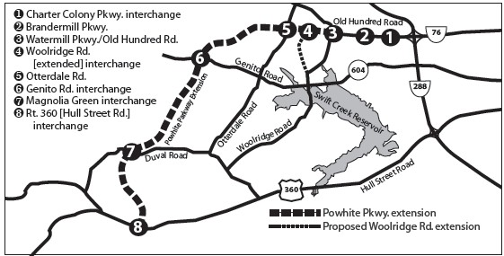
State Route 76 (SR 76) is a state highway in the U.S. state of Virginia. Known as Powhite Parkway (first word officially pronounced , similar to Powhatan), the state highway runs from SR 652 near Midlothian north to Interstate 195 (I-195) in Richmond. SR 76 is a toll freeway that connects SR 288, U.S. Route 60 (US 60), and SR 150 in Chesterfield County with I-195 and SR 195 west of Downtown Richmond. The highway includes a pair of mainline barrier toll plazas and ramp toll plazas at most interchanges, all of which accept E-ZPass. SR 76 is maintained by the Virginia Department of Transportation (VDOT) in Chesterfield County and the Richmond Metropolitan Authority in the city of Richmond. The Richmond section of the freeway was constructed in the early 1970s; the highway was extended to its current terminus in Chesterfield County in the late 1980s. Route description SR 76 begins at an arbitrary point just east of an intersection with Brandermill Parkway, the main stree ... [...More Info...] [...Related Items...] OR: [Wikipedia] [Google] [Baidu] |
I-195 (VA)
Interstate 195 (I-195) is an auxiliary Interstate Highway in the US state of Virginia. Known as the Beltline Expressway, the highway runs from Virginia State Route 195, State Route 195 (SR 195), a toll road that continues south into Downtown Richmond, Virginia, Downtown Richmond, north to Interstate 64 in Virginia, I-64 and Interstate 95 in Virginia, I-95 on the northern edge of Richmond, Virginia, Richmond. I-195 passes through the West End (Richmond, Virginia), West End of Richmond and connects I-64 and I-95 with U.S. Route 33 in Virginia, US Route 33 (US 33) and U.S. Route 250 in Virginia, US 250, which follow Broad Street, and with Virginia State Route 76, SR 76, a toll road that links Richmond with the Southside (Richmond, Virginia), Southside of Greater Richmond Region, the metropolitan area. Route description I-195 begins as a continuation of SR 195 (Downtown Expressway), a toll road that connects I-195 with I-95 in Downtown Richm ... [...More Info...] [...Related Items...] OR: [Wikipedia] [Google] [Baidu] |

_1.jpg)
