|
Vihorlat-Gutin Area
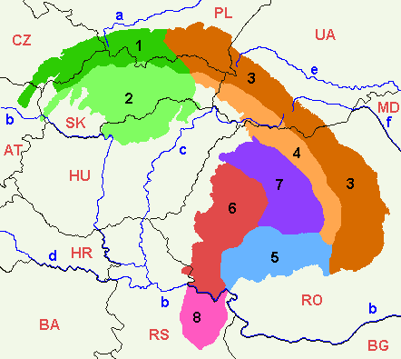
The Vihorlat-Gutin Area ( sk, Vihorlatsko-gutinská oblasť; uk, Вигорлат-Гутинський хребет; hu, Vihorlát–Gutin-hegyvidék) is a region of mountain ranges ranging from eastern Slovakia, through western Ukraine, into northern Romania. Geologically these ranges are considered part of the Inner Eastern Carpathians. Within Romania, however, it is traditional to divide the Eastern Carpathians in Romanian territory into three geographical groups (north, center, south), instead in "inner" and "outer" sections. The Romanian portions of Vihorlat-Gutin Area are considered part of the northern Carpathians of Maramureş and Bucovina ( ro, Munţii Carpaţi ai Maramureşului şi Bucovinei). Subdivisions These mountain ranges include: * Vihorlat Mountains ( sk, Vihorlatské vrchy; ua, Вигорлат), encompassing the Vihorlat Protected Landscape Area and the Morské oko (SK and UA); marked a1 on the map * Makovytsia ( ua, Маковиця); marked a2 o ... [...More Info...] [...Related Items...] OR: [Wikipedia] [Google] [Baidu] |
Divisions Of The Carpathians
Divisions of the Carpathians are a categorization of the Carpathian mountains system. Below is a detailed overview of the major subdivisions and ranges of the Carpathian Mountains. The Carpathians are a "subsystem" of a bigger Alps-Himalaya System that stretches from western Europe all the way to southern Asia, and are further divided into "provinces" and "subprovinces". The last level of the division, i.e. the actual mountain ranges and basins, is usually classified as "units". The main divisions are shown in the map on the right. To generalize, there are three major provinces (regions): Western Carpathians, Eastern Carpathians, and the Southern Carpathians. Naming conventions The division is largely (with many exceptions) undisputed at the lowest level (except for the Ukrainian part), but various divisions are given for the higher levels, especially for the penultimate level. A geomorphological division has been used as much as the data was available; other new physiogeo ... [...More Info...] [...Related Items...] OR: [Wikipedia] [Google] [Baidu] |
Velikyi Dil
{{Disambiguation, geo, surname ...
Veliky, or similar, may refer to: *Veliky (rural locality) (''Velikaya'', ''Velikoye''), name of several rural localities in Russia *Veliky (surname) *Velikaya, a river in Pskov Oblast, Russia *Velikaya (Chukotka), a river in Chukotka, Russia See also *Petr Veliky (other) or Peter the Great *Sissoi Veliky (other) *Velika (other) Velika (Cyrillic: Велика; "great" (fem.) in South Slavic) may refer to: Places * Velika (bishopric), a medieval bishopric associated with Clement of Ohrid * Velika, Bosnia and Herzegovina, a village in Derventa * Velika Kladuša, Bosnia and ... [...More Info...] [...Related Items...] OR: [Wikipedia] [Google] [Baidu] |
Mountain Ranges Of The Eastern Carpathians
A mountain is an elevated portion of the Earth's crust, generally with steep sides that show significant exposed bedrock. Although definitions vary, a mountain may differ from a plateau in having a limited summit area, and is usually higher than a hill, typically rising at least 300 metres (1,000 feet) above the surrounding land. A few mountains are isolated summits, but most occur in mountain ranges. Mountains are formed through tectonic forces, erosion, or volcanism, which act on time scales of up to tens of millions of years. Once mountain building ceases, mountains are slowly leveled through the action of weathering, through slumping and other forms of mass wasting, as well as through erosion by rivers and glaciers. High elevations on mountains produce colder climates than at sea level at similar latitude. These colder climates strongly affect the ecosystems of mountains: different elevations have different plants and animals. Because of the less hospitable terrain and ... [...More Info...] [...Related Items...] OR: [Wikipedia] [Google] [Baidu] |
Romanian Carpathians
The Romanian Carpathians ( ro, Carpații românești) are a section of the Carpathian Mountains, within the borders of modern Romania. The Carpathians are a "subsystem" of the Alps-Himalaya System and are further divided into "provinces" and "subprovinces". This is an overview of the geological subdivisions of the Romanian section of the Carpathian Mountains. The broadest divisions are shown in the map on the right. The last level of the division, i.e. the actual mountain ranges and basins, is usually called "units". The lowest-level detail for those units is maintained on separate pages. Naming conventions Traditional Romanian naming conventions differ from this list. In Romania, it is usual to divide the Eastern Carpathians in Romanian territory into three geographical groups (North, Centre, South), instead in Outer and Inner Eastern Carpathians. The Transylvanian Plateau is encircled by, and geologically a part of, the Carpathians, but it is not a mountainous region and it ... [...More Info...] [...Related Items...] OR: [Wikipedia] [Google] [Baidu] |
Ukrainian Carpathians
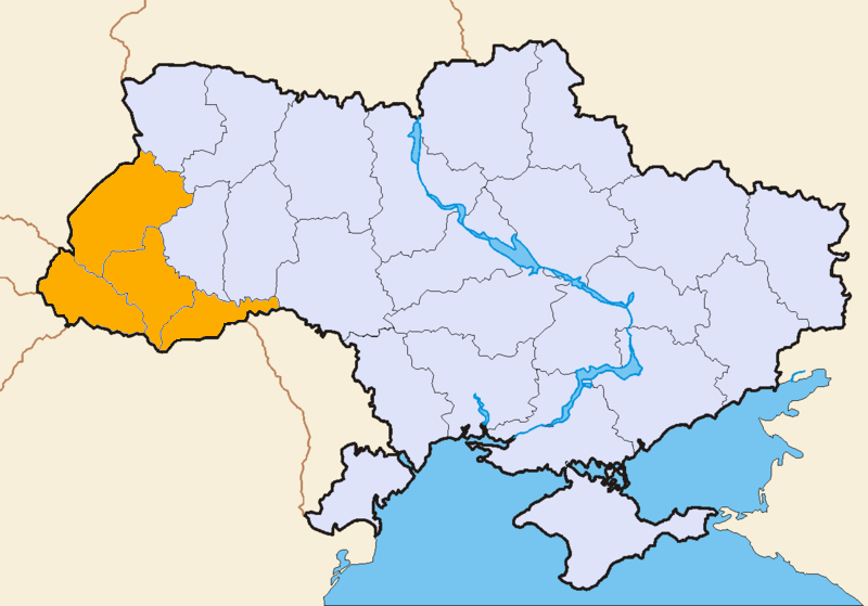
The Ukrainian Carpathians ( uk, Українські Карпати) are a section of the Eastern Carpathians, within the borders of modern Ukraine. They are located in the southwestern corner of Western Ukraine, within administrative territories of four Ukrainian regions (oblasts), covering northeastern part of Zakarpattia Oblast, southwestern part of Lviv Oblast, southern half of Ivano-Frankivsk Oblast and western half of Chernivtsi Oblast. They are stretching in general northwest–southeast direction, starting at the tripartite border point of Ukraine with Poland and Slovakia, and continuing towards Ukrainian border with Romania. In terms of geological classification, Ukrainian Carpathians belong to two distinctive categories, with major part belonging to the Outer Eastern Carpathians and minor part to the Inner Eastern Carpathians. Within different regional and national traditions, there are several overlapping variants of divisions and designations for variou ... [...More Info...] [...Related Items...] OR: [Wikipedia] [Google] [Baidu] |
Zemplínska šírava
Zemplínska šírava (sometimes called the "Slovak sea" ( sk, Slovenské more, hu, Széles-tó). is a dam and lake in eastern Slovakia, near the town of Michalovce, wholly belonging to the Michalovce District. The name recalls the historical Zemplín region. The dam was built in 1961–1965, covers an area of , has an average depth of , with a maximum depth of . Water from the dam flows into the Laborec river, which in turn flows into the Bodrog The Bodrog is a river in eastern Slovakia and north-eastern Hungary. It is a tributary to the river Tisza. The Bodrog is formed by the confluence of the rivers Ondava and Latorica near Zemplín in eastern Slovakia. It crosses the Slovak–H ... river. The area is primarily used for recreation. It also supplies cooling water for the Vojany Power Station. Panorama External links Zemplinska sirava Dams in Slovakia Reservoirs in Slovakia Geography of Košice Region Tourist attractions in Košice Region {{Slovakia-s ... [...More Info...] [...Related Items...] OR: [Wikipedia] [Google] [Baidu] |
Gutin Mountains
The Gutin Mountains (; hu, Gutin-hegység; uk, Гутинський масив) are a mountain range within the Vihorlat-Gutin Area of the Inner Eastern Carpathians. They are centered in Maramureș County in Romania, bordering Satu Mare County, and also stretching further towards northwest as the Oaș Mountains, and reaching the border with Zakarpattia Oblast in Ukraine. Its highest mountain is Gutâi Peak, with an altitude of . The northern sections of Gutin Mountains contain the volcanic mountain chain ''Creasta Cocoșului'' (Cock's comb), peaking at . See also * Romanian Carpathians * Ukrainian Carpathians The Ukrainian Carpathians ( uk, Українські Карпати) are a section of the Eastern Carpathians, within the borders of modern Ukraine. They are located in the southwestern corner of Western Ukraine, within administrative territor ... References Sources * External links Gutin Mountains on the geographical map of Maramureș CountyGutin and Oaș Moun ... [...More Info...] [...Related Items...] OR: [Wikipedia] [Google] [Baidu] |
Oaș Depression
Oaş may refer to: * Oaş Country, an ethnographic region in northwestern Romania ** Negreşti-Oaş, a town in Satu Mare County ** Călineşti-Oaş, a commune in Satu Mare County *Oaş, a village in Frata Commune, Cluj County, Romania {{DEFAULTSORT:Oas ... [...More Info...] [...Related Items...] OR: [Wikipedia] [Google] [Baidu] |
Oaș Mountains
The Oaș Mountains ( ro, Munţii Oașului, hu, Avas-hegység, uk, Гори Оаш) are a small volcanic mountain range within the Vihorlat-Gutin Area of the Inner Eastern Carpathians. The mountains are centered in northern section of the Oaș Country, covering border area between the Satu Mare County in Romania, and the Zakarpattia Oblast in Ukraine. They are an extension of the Gutin Mountains. Its highest mountain is Peak Piatra Vâscului, reaching . See also * Oaș Country * Romanian Carpathians * Ukrainian Carpathians The Ukrainian Carpathians ( uk, Українські Карпати) are a section of the Eastern Carpathians, within the borders of modern Ukraine. They are located in the southwestern corner of Western Ukraine, within administrative territor ... References Sources * External links Oaș Mountains on the northern section map of Satu Mare County Mountain ranges of the Eastern Carpathians Mountain ranges of Romania Mountain ranges of Ukrai ... [...More Info...] [...Related Items...] OR: [Wikipedia] [Google] [Baidu] |


