|
Velika Kapela
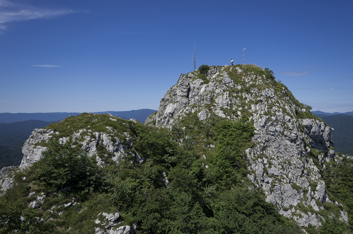
The Velika Kapela (; lit. ''Great Chapel'') is a large mountain range in the east of Gorski Kotar, Croatia. The highest peak is Bjelolasica-Kula at 1533 m.a.s.l. It overlooks Velebit, Plješivica, islands Krk, Cres, Lošinj, and the Kvarner Gulf. Velika Kapela belongs to the Dinaric Alps, and it stretches from the Gorski Kotar region in the west, to the Mala Kapela and Lika in the east, from the Ogulin-Plaški valley in the north, to the Vinodol coastline in the south. The area is narrowest mountain prague between continental Pannonia and the coastal Mediterranean. Velika Kapela is mainly composed of karst — limestone rocks. On the Velika Kapela there are many protected areas and landscapes. The famous are White cliffs and Samarske cliffs ( hr, Bijele i Samarske stijene), and Klek above Frankopan town of Ogulin. See also * List of mountains in Croatia This is a list of mountains ( hr, planina) in Croatia. The highest mountains in Croatia belong to the Dinarides range t ... [...More Info...] [...Related Items...] OR: [Wikipedia] [Google] [Baidu] |
Tržan Castle In Modruš
The Tržan Castle (; hr, Tržan-grad or ''Utvrda Tržan'') is a ruined medieval castle above the village of Modruš in the northern part of historical Lika region, central Croatia. Before (from the 11th century) the administrative seat of the former Modruš County (later renamed Modruš-Rijeka County), it is today a ruin in the Josipdol Municipality in the southern part of the Karlovac County. Having been built on a ridge of a steep hill above sea level on the eastern slopes of the Velika Kapela mountain, the castle was at a strategic place overlooking the road that connected the Adriatic Sea and the Pannonian Basin since ancient times. The road in question connected the Roman towns of Senia (present-day Senj) and Siscia (present-day Sisak). It was later, during the 18th century, reconstructed, improved and renamed as Josephina road. History According to the famous Croatian historian Vjekoslav Klaić (1849–1928), a kind of a castle or stronghold most probably existed above ... [...More Info...] [...Related Items...] OR: [Wikipedia] [Google] [Baidu] |
Ogulin-Plaški Valley
Ogulin-Plaški valley ( hr, Ogulinsko-plaščanska udolina) is a valley in the mountainous part of central Croatia, named after the towns of Ogulin and Plaški. It is located at an elevation of 300 to 380 meters above sea level, surrounded by the Dinaric Alps, namely the mountains of Velika Kapela, Mala Kapela, Krpelj, Radošić, Brezovica, Hum, and Pištenik. Its total area is around . The two namesakes of the valley also include karst fields or polje, those of Ogulin (, ) and of Plaški (, ). The A1 motorway A1, A-1, A01 or A.1. may refer to: Education * A1, the Basic Language Certificate of the Common European Framework of Reference for Languages * Language A1, the former name for "Language A: literature", one of the IB Group 1 subjects * A1, a ... intersects the valley near Oštarije. The D42 road and the M604 railway pass through it longitudinally. References {{Karlovac-geo-stub Plains of Croatia Landforms of Karlovac County ... [...More Info...] [...Related Items...] OR: [Wikipedia] [Google] [Baidu] |
Mountain Ranges Of Croatia
A mountain is an elevated portion of the Earth's crust, generally with steep sides that show significant exposed bedrock. Although definitions vary, a mountain may differ from a plateau in having a limited summit area, and is usually higher than a hill, typically rising at least 300 metres (1,000 feet) above the surrounding land. A few mountains are isolated summits, but most occur in mountain ranges. Mountains are formed through tectonic forces, erosion, or volcanism, which act on time scales of up to tens of millions of years. Once mountain building ceases, mountains are slowly leveled through the action of weathering, through slumping and other forms of mass wasting, as well as through erosion by rivers and glaciers. High elevations on mountains produce colder climates than at sea level at similar latitude. These colder climates strongly affect the ecosystems of mountains: different elevations have different plants and animals. Because of the less hospitable terrain and ... [...More Info...] [...Related Items...] OR: [Wikipedia] [Google] [Baidu] |
List Of Mountains In Croatia
This is a list of mountains ( hr, planina) in Croatia. The highest mountains in Croatia belong to the Dinarides range that is sometimes also called Dinaric Alps, of which Dinara is the highest mountain in Croatia. Together with the easternmost parts of the Alps, these mountains span most of the country, and their orogenic activity started in the Paleozoic with the Variscan orogeny and continued in the Mesozoic and Cenozoic with the Alpine orogeny. The mountains in the northeastern part of the country, in the Pannonian plain, are considerably older than the rest as their orogeny happened in the Paleozoic. Mountains in the list are ordered by height. See also * Geography of Croatia * List of rivers in Croatia * List of lakes in Croatia * Croatian Mountaineering Association Notes Sources * Further reading * Dr. Željko Poljak "Hrvatske planine" Zagreb, 2001. * Greater Geographical Atlas of Yugoslavia, University Press "Liber", Zagreb (Croatia), 1987. * Geographical ... [...More Info...] [...Related Items...] OR: [Wikipedia] [Google] [Baidu] |
Ogulin
Ogulin () is a town in north-western Croatia, in Karlovac County. It has a population of 7,389 (2021) (it was 8,216 in 2011), and a total municipal population of 12,251 (2021). Ogulin is known for its historic stone castle, known as Kula, and the nearby mountain of Klek. Toponymy There are several proposed etymologies for the name of Ogulin. Firstly that the surrounding woods needed to be cleared for a better defence of the town, so Ogulin received its name because of the resulting bare area ("ogolio" in Croatian) around it. There were a lot of lime-trees along the road from Ogulin towards Oštarije, and the people used to peel the bark, in order to get bass. It is suggested that Ogulin got its name from the verb to peel ("guliti" in Croatian). Neither proposal is historically confirmed. History Ogulin's history dates back to the fifteenth century, when it struggled against the Ottoman Turks. The exact timing of the building of the Ogulin tower has not been established. However, ... [...More Info...] [...Related Items...] OR: [Wikipedia] [Google] [Baidu] |
Frankopan
The House of Frankopan ( hr, Frankopani, Frankapani, it, Frangipani, hu, Frangepán, la, Frangepanus, Francopanus), was a Croatian noble family, whose members were among the great landowner magnates and high officers of the Kingdom of Croatia in union with Hungary. The Frankopans, along with the Zrinskis, are among the most important and most famous Croatian noble families who, from the 11th to the 17th century, were very closely connected with the history, past and destiny of the Croatian people and Croatia. For centuries, members of these noble clans were the bearers and defenders of Croatia against the Ottomans, but also resolute opponents of the increasingly dangerous Habsburg imperial absolutism and German hegemony, which in the spirit of European mercantilism sought to consolidate throughout the Habsburg Monarchy. The past of these two clans is intertwined with marital ties, friendships and participation in almost all significant events in Croatia, especially on the ba ... [...More Info...] [...Related Items...] OR: [Wikipedia] [Google] [Baidu] |
Klek Mountain, Croatia
Klek is mountain in north-western Croatia, near Ogulin in Karlovac County. It is the easternmost mountain of the Velika Kapela range of the Dinaric Alps. The mountain is one of the best-known Croatian botanist reserves and home to a number of protected species of mountain flora. According to the 17th century tale, during the nights of storm, the summit of Klek is a midnight gathering point for witches and fairies. In the early 20th century, Klek's east and south face nurtured numerous Croatian rock climbers. The longest route length exceeds 200 m, with difficulty up to 5.12a. Geography and geology Klek is positioned as a prominent ridge on the eastern tips of Velika Kapela, and its slopes descend toward Ogulin and the valley of Dobra. The peaks are steep and rocky, and there are two most important ones, Klečice or Mali Klek (1058 m), and Veliki Klek (or just Klek, 1182 m), with its prominent vertical 200 meters high "southern rock". Klek rose during the Alpine orogeny i ... [...More Info...] [...Related Items...] OR: [Wikipedia] [Google] [Baidu] |
Limestone
Limestone ( calcium carbonate ) is a type of carbonate sedimentary rock which is the main source of the material lime. It is composed mostly of the minerals calcite and aragonite, which are different crystal forms of . Limestone forms when these minerals precipitate out of water containing dissolved calcium. This can take place through both biological and nonbiological processes, though biological processes, such as the accumulation of corals and shells in the sea, have likely been more important for the last 540 million years. Limestone often contains fossils which provide scientists with information on ancient environments and on the evolution of life. About 20% to 25% of sedimentary rock is carbonate rock, and most of this is limestone. The remaining carbonate rock is mostly dolomite, a closely related rock, which contains a high percentage of the mineral dolomite, . ''Magnesian limestone'' is an obsolete and poorly-defined term used variously for dolomite, for limes ... [...More Info...] [...Related Items...] OR: [Wikipedia] [Google] [Baidu] |
Karst
Karst is a topography formed from the dissolution of soluble rocks such as limestone, dolomite, and gypsum. It is characterized by underground drainage systems with sinkholes and caves. It has also been documented for more weathering-resistant rocks, such as quartzite, given the right conditions. Subterranean drainage may limit surface water, with few to no rivers or lakes. However, in regions where the dissolved bedrock is covered (perhaps by debris) or confined by one or more superimposed non-soluble rock strata, distinctive karst features may occur only at subsurface levels and can be totally missing above ground. The study of ''paleokarst'' (buried karst in the stratigraphic column) is important in petroleum geology because as much as 50% of the world's hydrocarbon reserves are hosted in carbonate rock, and much of this is found in porous karst systems. Etymology The English word ''karst'' was borrowed from German in the late 19th century, which entered German much earlier ... [...More Info...] [...Related Items...] OR: [Wikipedia] [Google] [Baidu] |
Mediterranean
The Mediterranean Sea is a sea connected to the Atlantic Ocean, surrounded by the Mediterranean Basin and almost completely enclosed by land: on the north by Western and Southern Europe and Anatolia, on the south by North Africa, and on the east by the Levant. The Sea has played a central role in the history of Western civilization. Geological evidence indicates that around 5.9 million years ago, the Mediterranean was cut off from the Atlantic and was partly or completely desiccated over a period of some 600,000 years during the Messinian salinity crisis before being refilled by the Zanclean flood about 5.3 million years ago. The Mediterranean Sea covers an area of about , representing 0.7% of the global ocean surface, but its connection to the Atlantic via the Strait of Gibraltar—the narrow strait that connects the Atlantic Ocean to the Mediterranean Sea and separates the Iberian Peninsula in Europe from Morocco in Africa—is only wide. The Mediterranean Sea ... [...More Info...] [...Related Items...] OR: [Wikipedia] [Google] [Baidu] |
Pannonia
Pannonia (, ) was a province of the Roman Empire bounded on the north and east by the Danube, coterminous westward with Noricum and upper Italy, and southward with Dalmatia and upper Moesia. Pannonia was located in the territory that is now western Hungary, western Slovakia, eastern Austria, northern Croatia, north-western Serbia, northern Slovenia, and northern Bosnia and Herzegovina. Name Julius Pokorny believed the name ''Pannonia'' is derived from Illyrian, from the Proto-Indo-European root ''*pen-'', "swamp, water, wet" (cf. English ''fen'', "marsh"; Hindi ''pani'', "water"). Pliny the Elder, in '' Natural History'', places the eastern regions of the Hercynium jugum, the "Hercynian mountain chain", in Pannonia and Dacia (now Romania). He also gives us some dramaticised description of its composition, in which the proximity of the forest trees causes competitive struggle among them (''inter se rixantes''). He mentions its gigantic oaks. But even he—if the passage in ... [...More Info...] [...Related Items...] OR: [Wikipedia] [Google] [Baidu] |
Vinodol, Croatia
Vinodol (; hr, Vinodolska općina) is a municipality in the Primorje-Gorski Kotar County in western Croatia. The total population of the municipality is 3,577 people, in the following settlements: * Bribir, population 1,695 * Drivenik, population 308 * Grižane-Belgrad, population 953 * Tribalj, population 621 The population is 93.4% Croats. The Law codex of Vinodol, a medieval Croatian codex, was made in and named after this region. The Vinodol Hydroelectric Power Plant is located in the region. The Vinodol Channel is the part of the Adriatic Sea to the south of the region. Notable people Notable people that were born or lived in Vinodol include: *Juraj Juričić (?–1578), Croatian-Slovenian Protestant preacher and translator *Julije Klović or Giulio Clovio (1498-1578), Croatian illuminator miniaturist painter considered the greatest illuminator of Italian high renaissance period See also * Geography of Croatia The geography of Croatia is defined by its location ... [...More Info...] [...Related Items...] OR: [Wikipedia] [Google] [Baidu] |


.jpg)


