|
Vargas (state)
) , anthem = ''Carmañola Americana'' , image_map = Vargas in Venezuela.svg , map_alt = , map_caption = Location within Venezuela , pushpin_map = , pushpin_map_alt = , pushpin_mapsize = , pushpin_map_caption = , coordinates = , coordinates_footnotes = , subdivision_type = Country , subdivision_name = Venezuela , subdivision_type1 = , subdivision_name1 = , subdivision_type2 = , subdivision_name2 = , established_title = Created , established_date = 1998 , founder = , named_for = , seat_type = Capital , seat = La Guaira , government_footnotes = , government_type = , leader_party = , governing_body= Legislative Council , leader_title = Governor , leader_name = José Manuel Suárez (2021–) , ... [...More Info...] [...Related Items...] OR: [Wikipedia] [Google] [Baidu] |
States Of Venezuela
The Bolivarian Republic of Venezuela is a federation made up of twenty-three states ('' es, estados''), a Capital District ('' es, Distrito Capital'') and the Federal Dependencies ('' es, Dependencias Federales''), which consist of many islands and islets in the Caribbean Sea. Venezuela also claims the Guayana Esequiba territory which comprises six districts in the independent nation of Guyana. The states and territories of Venezuela are usually organized into regions ( es, regiones), although these regions are mostly geographical entities rather than administrative entities. Historical states Prior to the Federal War (1859–1863), the country was divided into provinces rather than states (see Provinces of Venezuela). The victorious forces were supposed to grant more autonomy to the individual states, but this was not implemented. From 1863 to the early 1900s there were numerous territorial changes, including the merger and splitting of states, but from then unt ... [...More Info...] [...Related Items...] OR: [Wikipedia] [Google] [Baidu] |
Aragua (state)
Aragua State ( es, Estado Aragua, ) is one of the 23 states of Venezuela. It is located in the north-central region of Venezuela. It has plains and jungles and Caribbean beaches. The most popular are Cata and Choroni. It has Venezuela's first national park which is called Henri Pittier. The capital is Maracay, other important cities include Turmero and El Limón. Aragua State covers a total surface area of and, based on the 2011 census information, the estimated population of Aragua State in 2012 is 1,630,308 inhabitants. Etymology The name of the state comes from an indigenous word of Cumanagoto (Caribbean) origin, which is used to refer to the Chaguaramo, a type of palm from the region uotation requiredHowever, according to Carlos Blanco Galeno, a chronicler from Turmero, it derives from the Cariban aregua, and this de are ('site') and gua which in turn derives from ogun ('my thing'), so it would mean 'my place, my country'. This same word inspired the name of the Ar ... [...More Info...] [...Related Items...] OR: [Wikipedia] [Google] [Baidu] |
Cordillera De La Costa Central
The Cordillera de la Costa Central is a range of the Venezuelan Coastal Ranges System (''Cordillera de la Costa''), in northern Venezuela. Geography The mountain range runs east— west along the northern Caribbean Sea coast. It is also known as the Central Range. In the east the Cordillera de la Costa Central follow the border between the states of Vargas and Miranda. They then pass through the states of Aragua and Carabobo, and the eastern part of the state of Yaracuy, and they terminate south of the Yaracuy river in the northern part of the state of Cojedes. Ecology Between , the mountains are covered by montane evergreen forests and Cordillera de la Costa montane forests (ecoregion). The range forms part of an Endemic Bird Area, as designated by Birdlife International BirdLife International is a global partnership of non-governmental organizations that strives to conserve birds and their habitats. BirdLife International's priorities include preventing extinction ... [...More Info...] [...Related Items...] OR: [Wikipedia] [Google] [Baidu] |
Rafael Caldera
Rafael Antonio Caldera Rodríguez ( (); 24 January 1916 – 24 December 2009), twice elected the president of Venezuela, served for two five-year terms (1969–1974 and 1994–1999), becoming the longest serving democratically elected leader to govern the country in the twentieth century. His first term marked the first peaceful transfer of power to the opposition in Venezuela's history. Widely acknowledged as one of the founders of Venezuela's democratic system,John D. Martz, "Venezuela, Colombia, and Ecuador," in Jan Knippers Black, ed. ''Latin America, Its Problems and Its Promise'', 2nd ed. (Boulder, Colorado: Westview Press, 1991), 439 one of the main architects of the 1961 Constitution, and a pioneer of the Christian Democratic movement in Latin America, Caldera helped forge an unprecedented period of civilian democratic rule in a country beleaguered by a history of political violence and military caudillos. His leadership established Venezuela's reputation as one of ... [...More Info...] [...Related Items...] OR: [Wikipedia] [Google] [Baidu] |
Libertador Bolivarian Municipality
The Libertador Bolivarian Municipality ( es, Municipio Bolivariano Libertador) is the only administrative division of the Capital District and along with the municipalities of Baruta, Chacao, El Hatillo and Sucre forms the Metropolitan District of Caracas. It is landlocked by Vargas State and also borders Miranda State on the east and south. The municipality is one of a number in Venezuela named " Libertador Municipality", in honour of Venezuelan independence hero Simón Bolívar. Libertador is one of the smallest municipalities in Venezuela, with a total area of . It is the largest in terms of population, with approximately 2.1 million inhabitants. In this municipality is home to the Miraflores presidential palace, the Federal Legislative Palace, the National Electoral Council, the main offices of PDVSA and CANTV, the Central Bank of Venezuela and the public ministry. History It was first established in 1901 under the name of Libertador Department; with the Departmen ... [...More Info...] [...Related Items...] OR: [Wikipedia] [Google] [Baidu] |
Ferdinand Bellermann 1844-45 000
Ferdinand is a Germanic name composed of the elements "protection", "peace" (PIE "to love, to make peace") or alternatively "journey, travel", Proto-Germanic , abstract noun from root "to fare, travel" (PIE , "to lead, pass over"), and "courage" or "ready, prepared" related to Old High German "to risk, venture." The name was adopted in Romance languages from its use in the Visigothic Kingdom. It is reconstructed as either Gothic or . It became popular in German-speaking Europe only from the 16th century, with Habsburg rule over Spain. Variants of the name include , , , and in Spanish, in Catalan, and and in Portuguese. The French forms are , ''Fernand'', and , and it is '' Ferdinando'' and in Italian. In Hungarian both and are used equally. The Dutch forms are and '' Ferry''. There are numerous short forms in many languages, such as the Finnish . There is a feminine Spanish, Portuguese and Italian form, . Royalty Aragón/León/Castile/Spain *Ferdi ... [...More Info...] [...Related Items...] OR: [Wikipedia] [Google] [Baidu] |
Vargas Tragedy
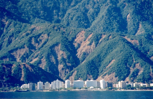
The Vargas tragedy was a natural disaster that occurred in Vargas State, Venezuela on 14–16 December 1999, when torrential rains caused flash floods and debris flows that killed tens of thousands of people, destroyed thousands of homes, and led to the complete collapse of the state's infrastructure. According to relief workers, the neighborhood of Los Corales was buried under of mud and a high percentage of homes were simply swept into the ocean. Entire towns including Cerro Grande and Carmen de Uria completely disappeared. As much as 10% of the population of Vargas died during the event. Background The coastal area of Vargas State has long been subject to mudslides and flooding. Deposits preserved on the alluvial fan deltas here show that geologically similar catastrophes have occurred with regularity since prehistoric times. Since the 17th century, at least two large-magnitude debris flow, landslide, or flood events, on average, have occurred each century within the mode ... [...More Info...] [...Related Items...] OR: [Wikipedia] [Google] [Baidu] |
Greater Caracas Area
Metropolitan Region of Caracas (MRC) or Greater Caracas (GC) ( es, Región Metropolitana de Caracas; RMC or ''Gran Caracas''; GC) is the urban agglomeration comprising the Metropolitan District of Caracas and the adjacent 11 municipalities over Miranda and Vargas state in Venezuela Venezuela (; ), officially the Bolivarian Republic of Venezuela ( es, link=no, República Bolivariana de Venezuela), is a country on the northern coast of South America, consisting of a continental landmass and many islands and islets in .... Thus, it does not constitute a single administrative unit. The conurbation spreads south, west, east and north of Caracas. It has a population of 5,243,301. Geography Metropolitan divisions The Metropolitan Region of Caracas consists of five distinct metropolitan divisions/conurbations, subdividing the region into five divisions. References External links Alcaldía Mayor MetropolitanaEstado MirandaEstado Vargas Caracas Geography of Capital ... [...More Info...] [...Related Items...] OR: [Wikipedia] [Google] [Baidu] |
Litoral Varguense Conurbation
Litoral Varguense conurbation ( es, Conurbación del Litoral Varguense is a metropolitan area in Vargas, Venezuela, that includes 10 parishes, it is part of the Greater Caracas Area.http://159.90.80.55/tesis/000150053.pdf It has a population of 341,325 inhabitants. Cities The principal cities of the area are (2013): # Maiquetia (it holds the parishes of Maiquetia, Carlos Soublette and Urimare) (pop. 118,807) # Catia La Mar (pop. 98,487) # Carayaca (pop. 40,096) # Caraballeda (pop. 29,982) # La Guaira (pop. 20,228) # Macuto (pop. 15,562) # Naiguatá (pop. 14,516) Parishes The 10 parishes of the area are: Tourism Beaches See also * Greater Caracas * List of metropolitan areas of Venezuela References External links *History History (derived ) is the systematic study and the documentation of the human activity. The time period of event before the History of writing#Inventions of writing, invention of writing systems is considered prehistory. "History" is an u ... [...More Info...] [...Related Items...] OR: [Wikipedia] [Google] [Baidu] |
Caracas Airport
Caracas (, ), officially Santiago de León de Caracas, abbreviated as CCS, is the capital and largest city of Venezuela, and the center of the Metropolitan Region of Caracas (or Greater Caracas). Caracas is located along the Guaire River in the northern part of the country, within the Caracas Valley of the Venezuelan coastal mountain range (Cordillera de la Costa). The valley is close to the Caribbean Sea, separated from the coast by a steep 2,200-meter-high (7,200 ft) mountain range, Cerro El Ávila; to the south there are more hills and mountains. The Metropolitan Region of Caracas has an estimated population of almost 5 million inhabitants. The center of the city is still ''Catedral'', located near Bolívar Square, though some consider the center to be Plaza Venezuela, located in the Los Caobos area. Businesses in the city include service companies, banks, and malls. Caracas has a largely service-based economy, apart from some industrial activity in its metropolitan are ... [...More Info...] [...Related Items...] OR: [Wikipedia] [Google] [Baidu] |


.png)
