|
Valtos Province
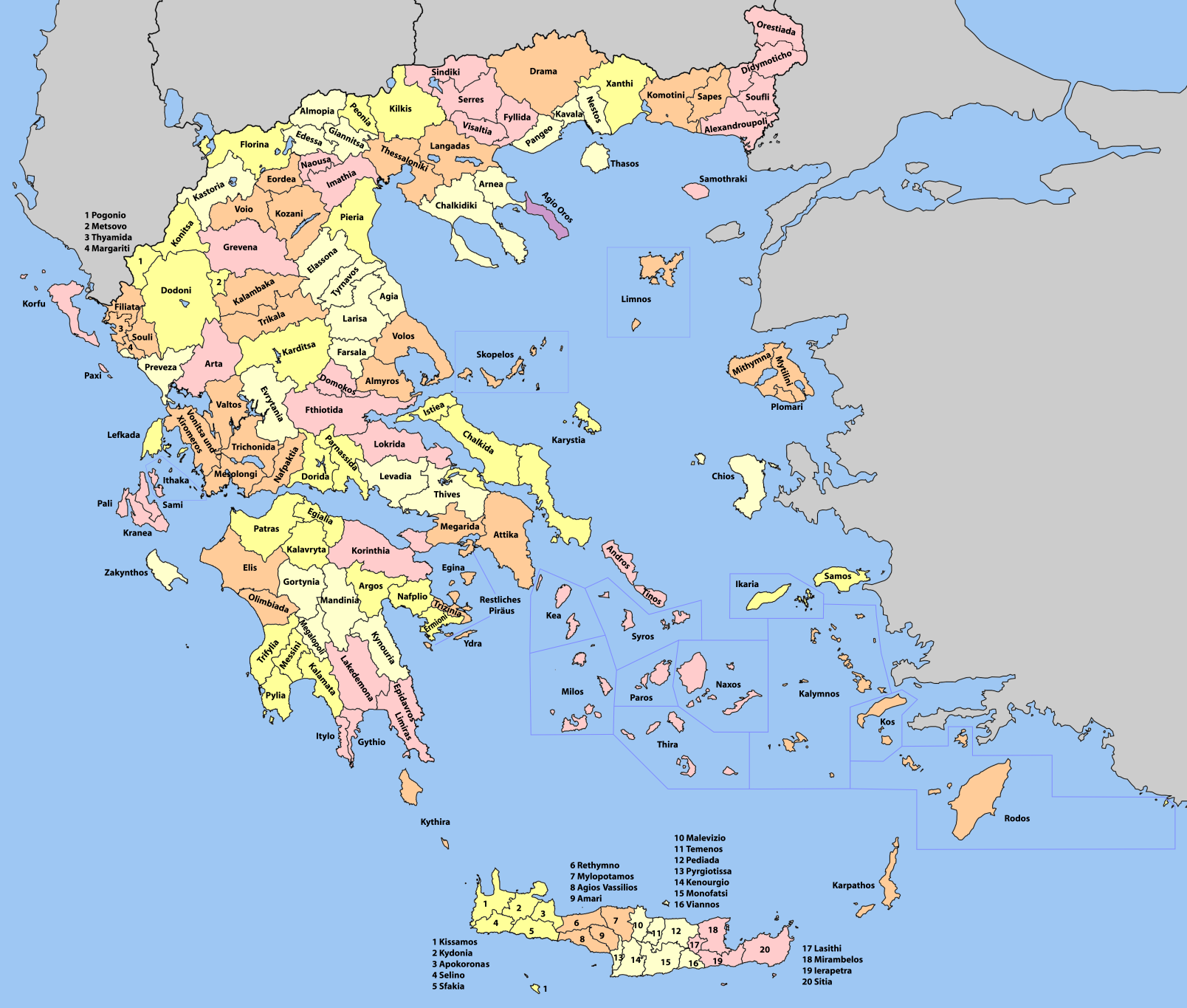
Valtos Province ( el, Επαρχία Βάλτου) is one of the five former provinces of Aetolia-Acarnania in Greece. It lies in the northern part of Aetolia-Acarnania. Its capital was Amfilochia. The Acheloos River was the border of the province to Evrytania. Its territory corresponded with that of the current municipality Amfilochia and the municipal unit Stratos. It was abolished in 2006. During Ottoman rule, the region of Valtos (which means "swamp" in Greek) was a haven for bandits and brigands. During the struggle for the liberation of Greece Valtos contributed many fighters and leaders to the Greek Revolution The Greek War of Independence, also known as the Greek Revolution or the Greek Revolution of 1821, was a successful war of independence by Greek revolutionaries against the Ottoman Empire between 1821 and 1829. The Greeks were later assisted b .... References Aetolia-Acarnania Provinces of Greece {{WGreece-geo-stub ... [...More Info...] [...Related Items...] OR: [Wikipedia] [Google] [Baidu] |
Provinces Of Greece
The provinces of Greece ( el, επαρχία, " eparchy") were sub-divisions of some the country's prefectures. From 1887, the provinces were abolished as actual administrative units, but were retained for some state services, especially financial and educational services, as well as for electoral purposes. Before the Second World War, there were 139 provinces, and after the war, with the addition of the Dodecanese Islands, their number grew to 147. According to the Article 7 of the Code of Prefectural Self-Government (Presidential Decree 30/1996), the provinces constituted a "particular administrative district" within the wider "administrative district" of the prefectures. The provinces were finally abolished after the 2006 local elections, in line with Law 2539/1997, as part of the wide-ranging administrative reform known as the " Kapodistrias Project", and replaced by enlarged municipalities (''demoi''). Organization Provincial administration consisted of two parts: a col ... [...More Info...] [...Related Items...] OR: [Wikipedia] [Google] [Baidu] |
Amfilochia
Amfilochia ( el, Αμφιλοχία) is a town and a municipality in the northwestern part of Aetolia-Acarnania in Greece, on the site of ancient Amfilochia. Under the Ottoman Empire, it was known as Karvasaras (Καρβασαράς; from ''caravanserai''). Amfilochia is situated by the Ambracian Gulf and features an amphitheatre. Amfilochia dates back to the ancient times and also features the ancient cities of Amphilochian Argos and Limnaia (or Limnaea). History According to Pausanias, it is named after king Amphilochos, son of Amphiaraus. After the fall of Troy, Amphilochos settled in the area, which consequently was called Amphilochoi until the time of Pausanias. Under the Ottoman Empire, Ali Pasha of Ioannina, forcibly relocated residents of another village to the current location of the town and established a motel (''serai'' in Turkish) to serve passing caravans. This was how the name Karvasaras came up. In July 1944 a battle took place in the town between ELAS ... [...More Info...] [...Related Items...] OR: [Wikipedia] [Google] [Baidu] |
Provinces Of Greece
The provinces of Greece ( el, επαρχία, " eparchy") were sub-divisions of some the country's prefectures. From 1887, the provinces were abolished as actual administrative units, but were retained for some state services, especially financial and educational services, as well as for electoral purposes. Before the Second World War, there were 139 provinces, and after the war, with the addition of the Dodecanese Islands, their number grew to 147. According to the Article 7 of the Code of Prefectural Self-Government (Presidential Decree 30/1996), the provinces constituted a "particular administrative district" within the wider "administrative district" of the prefectures. The provinces were finally abolished after the 2006 local elections, in line with Law 2539/1997, as part of the wide-ranging administrative reform known as the " Kapodistrias Project", and replaced by enlarged municipalities (''demoi''). Organization Provincial administration consisted of two parts: a col ... [...More Info...] [...Related Items...] OR: [Wikipedia] [Google] [Baidu] |
Aetolia-Acarnania
Aetolia-Acarnania ( el, Αιτωλοακαρνανία, ''Aitoloakarnanía'', ) is one of the regional units of Greece. It is part of the geographic region of Central Greece and the administrative region of West Greece. A combination of the historical regions of Aetolia and Acarnania, it is the country's largest regional unit. Its capital is Missolonghi for historical reasons, with its biggest city and economic centre at Agrinio. The area is now connected with the Peloponnese peninsula via the Rio-Antirio Bridge. The surrounding regional units take in Arta in Epirus, a narrow length bordering Karditsa of Thessaly, Evrytania to the northeast, and Phocis to the east. Geography Mountains dominate the north, northeast, west and southeast, especially the Acarnanian Mountains. The longest and main river is the Acheloos, which ends as a delta in wetlands to the southwest on a rich fertile valley. The second longest is Evinos; others include the Ermitsa, the Inachos, and the M ... [...More Info...] [...Related Items...] OR: [Wikipedia] [Google] [Baidu] |
Greece
Greece,, or , romanized: ', officially the Hellenic Republic, is a country in Southeast Europe. It is situated on the southern tip of the Balkans, and is located at the crossroads of Europe, Asia, and Africa. Greece shares land borders with Albania to the northwest, North Macedonia and Bulgaria to the north, and Turkey to the northeast. The Aegean Sea lies to the east of the mainland, the Ionian Sea to the west, and the Sea of Crete and the Mediterranean Sea to the south. Greece has the longest coastline on the Mediterranean Basin, featuring thousands of islands. The country consists of nine traditional geographic regions, and has a population of approximately 10.4 million. Athens is the nation's capital and largest city, followed by Thessaloniki and Patras. Greece is considered the cradle of Western civilization, being the birthplace of democracy, Western philosophy, Western literature, historiography, political science, major scientific and mathematica ... [...More Info...] [...Related Items...] OR: [Wikipedia] [Google] [Baidu] |
Acheloos River
The Achelous ( el, Αχελώος, grc, Ἀχελῷος ''Akhelôios''), also Acheloos, is a river in western Greece. It is long. It formed the boundary between Acarnania and Aetolia of antiquity. It empties into the Ionian Sea. In ancient times its spirit was venerated as the river god Achelous. Herodotus, taking notice of the shoreline-transforming power of the Acheloos River, even compared it to the Nile in this respect: :'There are other rivers as well which, though not as large as the Nile, have had substantial results. In particular (although I could name others), there is the Achelous, which flows through Acarnania into the sea and has already turned half the Echinades islands into mainland.' (2.10, trans. Waterfield) It is said to have been called more anciently ''Thoas'', ''Axenus'' and ''Thestius''. Course The river Achelous begins at about elevation on the eastern slope of Lakmos mountain in the Pindus range, near the village Anthousa in the westernmost part ... [...More Info...] [...Related Items...] OR: [Wikipedia] [Google] [Baidu] |
Evrytania
Evrytania ( el, Ευρυτανία, ; Latin: ''Eurytania'') is one of the regional units of Greece. It is part of the region of Central Greece. Its capital is Karpenisi (approx. 8,000 inhabitants). Geography Evrytania is almost entirely formed of mountains, including the Tymfristos and the Panaitoliko in the south. Its rivers include the Acheloos in the west, Agrafiotis to the east, and Megdova in the east flowing down to the Ionian Sea. It is one of the least populated regional units in Greece. The area borders Aetolia-Acarnania to the west, southwest and south (west over the Acheloos river), Karditsa regional unit to the north, and Phthiotis to the east. Evrytania also features a famous skiing resort located near Karpenisi on the Tymfristos mountain. Climate Its climate is a mixture of Mediterranean and mountainous in the western portion. Much of the area receives snow in winter and is warm during the summer months. Transport The Greek National Road 38 from Agrinio t ... [...More Info...] [...Related Items...] OR: [Wikipedia] [Google] [Baidu] |
Stratos, Greece
Stratos ( el, Στράτος, la, Stratus) is a settlement in central Aetolia-Acarnania, Western Greece. It is best known for its impressive remains of the namesake ancient Greek city and capital of Acarnania, which lie on a hillside about 500m north of the modern village. Stratos is situated on the right bank of the river Acheloos, 9 km northwest of the town of Agrinio. The area north of Stratos is mountainous, whereas the south is flat. It is now an Aromanian (Vlach) village and a municipal unit of the Agrinio municipality. History Its situation at the northern edge of the fertile Achelous River plain and on the strategic maritime route to Italy as well as the navigability of the river up to city made it a place of great military importance and Stratos emerged as the largest and best fortified city of Acarnania. It was where judicial proceedings common to all the Arcananians took place, and by Thucydides' time Stratos was the capital of Acarnania and the feder ... [...More Info...] [...Related Items...] OR: [Wikipedia] [Google] [Baidu] |
Ottoman Greece
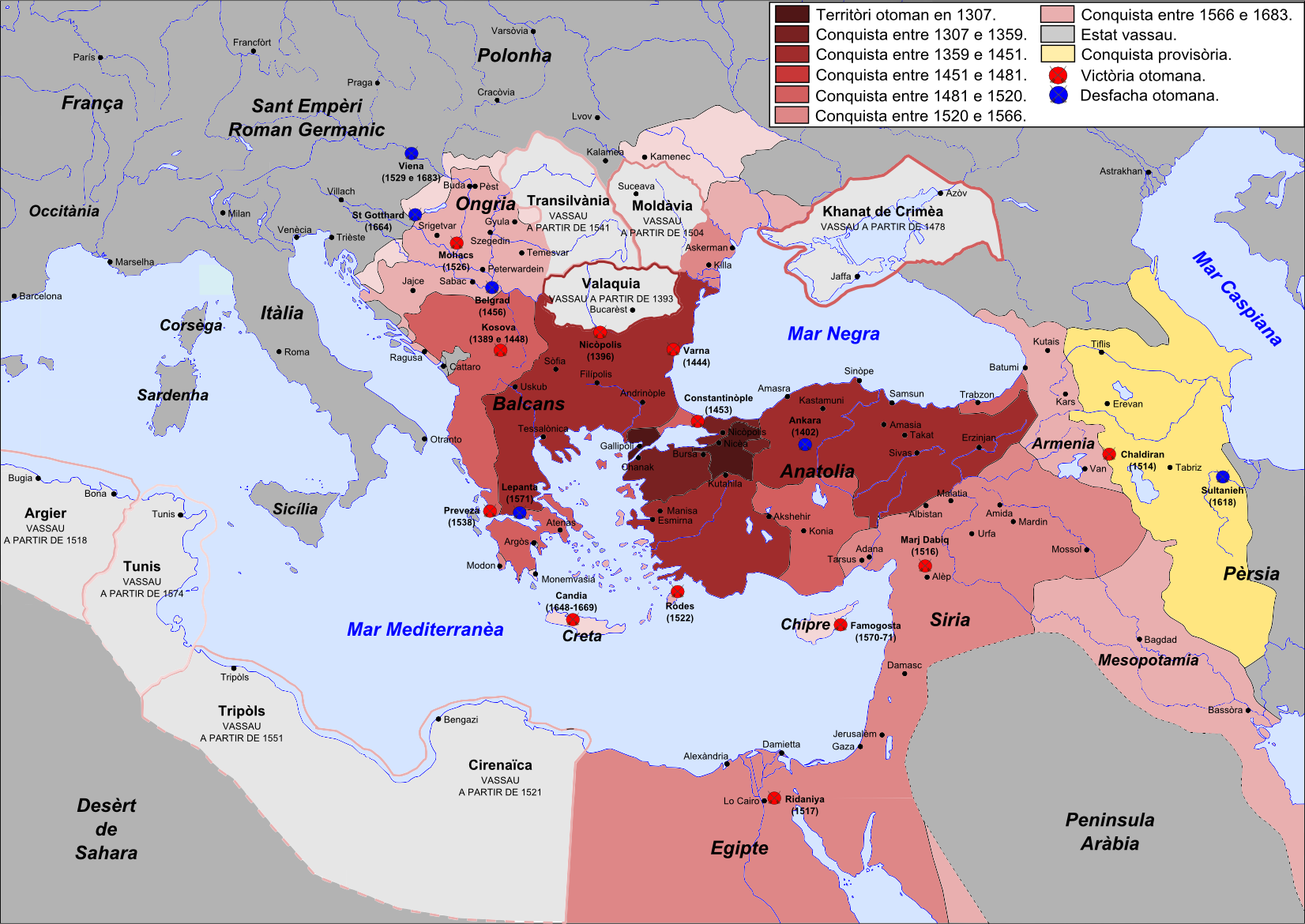
Most of the areas which today are within modern Greece's borders were at some point in the past part of the Ottoman Empire. This period of Ottoman rule in Greece, lasting from the mid-15th century until the successful Greek War of Independence that broke out in 1821 and the proclamation of the First Hellenic Republic in 1822 (preceded by the creation of the autonomous Septinsular Republic in 1800), is known in Greek as ''Tourkokratia'' ( el, Τουρκοκρατία, "Turkish rule"; en, "Turkocracy"). Some regions, however, like the Ionian islands, various temporary Venetian possessions of the Stato da Mar, or Mani peninsula in Peloponnese did not become part of the Ottoman administration, although the latter was under Ottoman suzerainty. The Eastern Roman Empire, the remnant of the ancient Roman Empire which ruled most of the Greek-speaking world for over 1100 years, had been fatally weakened since the sacking of Constantinople by the Latin Crusaders in 1204. The Ottoman ... [...More Info...] [...Related Items...] OR: [Wikipedia] [Google] [Baidu] |
Greek War Of Independence
The Greek War of Independence, also known as the Greek Revolution or the Greek Revolution of 1821, was a successful war of independence by Greek revolutionaries against the Ottoman Empire between 1821 and 1829. The Greeks were later assisted by the British Empire, Bourbon Restoration in France, Kingdom of France, and the Russian Empire, while the Ottomans were aided by their North African vassals, particularly the eyalet of Egypt Eyalet, Egypt. The war led to the formation of modern Greece. The revolution is Celebration of the Greek Revolution, celebrated by Greeks around the world as Greek Independence Day, independence day on 25 March. Greece, with the exception of the Ionian Islands, came under Ottoman rule in the 15th century, in the decades before and after the fall of Constantinople. During the following centuries, there were sporadic but unsuccessful Ottoman Greece#Uprisings before 1821, Greek uprisings against Ottoman rule. In 1814, a secret organization called Filiki Et ... [...More Info...] [...Related Items...] OR: [Wikipedia] [Google] [Baidu] |


