|
Usquepaug Road Historic District
The Usquepaug Road Historic District is a historic district near the village of Usquepaug in South Kingstown, Rhode Island. It consists of a collection of properties, mostly on the south side of Usequepaug Road (Rhode Island Route 138) between the Usquepaug Cemetery and Dugway Bridge Road. Although the area began as a rural, agricultural area, it developed into a modest rural village, with a church, school, and cluster of vernacular rural houses. The schoolhouse was destroyed in the New England Hurricane of 1938. The district was listed on the National Register of Historic Places in 1987. See also *National Register of Historic Places listings in Washington County, Rhode Island __NOTOC__ This is a list of the National Register of Historic Places listings in Washington County, Rhode Island. This is intended to be a complete list of the properties and districts on the National Register of Historic Places in Washington C ... References Historic districts in Washington ... [...More Info...] [...Related Items...] OR: [Wikipedia] [Google] [Baidu] |
South Kingstown, Rhode Island
South Kingstown is a town in, and the county seat of, Washington County, Rhode Island, United States. The population was 31,931 at the 2020 census. South Kingstown is the second largest town in Rhode Island by total geographic area, behind New Shoreham, and the third largest town in Rhode Island by geographic land area, behind Exeter and Coventry. History The Narragansett Indians were known to occupy a winter camp in the Great Swamp, within present day South Kingstown. In March of 1638, Rhode Island founder Roger Williams signed an agreement with two Sachems of the Narragansett Tribe, Canonicus and Miantonomoh, establishing the boundaries between the Narragansett Tribe and the Colony of Rhode Island, as well as to purchase Aquidneck Island. The agreement was signed at Pettaquamscutt Rock, which is now a part of South Kingstown. Twenty years later, on January 20, 1658, Roger Williams again met with the Sachems of the Narragansett Tribe to purchase much of the area that is now ... [...More Info...] [...Related Items...] OR: [Wikipedia] [Google] [Baidu] |
Historic District (United States)
Historic districts in the United States are designated historic districts recognizing a group of buildings, Property, properties, or sites by one of several entities on different levels as historically or architecturally significant. Buildings, structures, objects and sites within a historic district are normally divided into two categories, Contributing property, contributing and non-contributing. Districts vary greatly in size: some have hundreds of structures, while others have just a few. The U.S. federal government designates historic districts through the United States Department of the Interior, United States Department of Interior under the auspices of the National Park Service. Federally designated historic districts are listed on the National Register of Historic Places, but listing usually imposes no restrictions on what property owners may do with a designated property. U.S. state, State-level historic districts may follow similar criteria (no restrictions) or may req ... [...More Info...] [...Related Items...] OR: [Wikipedia] [Google] [Baidu] |
Usquepaug, Rhode Island
Usquepaug is a village in the towns of Richmond and South Kingstown in Washington County, Rhode Island, United States. It is located along the Usquepaug River. A portion of the village is listed on the National Register of Historic Places as the Usquepaug Road Historic District. Overview The village is the location of Kenyon Corn Meal Company, a gristmill founded in the late 17th century, and currently located in a building constructed in 1886. The white corn meal is used in a traditional Rhode Island food, johnnycake Johnnycake, also known as journey cake, johnny bread, hoecake, shawnee cake or spider cornbread, is a cornmeal flatbread, a type of batter bread. An early American staple food, it is prepared on the Atlantic coast from Newfoundland to Jamaica. ...s and the annual Johnny Cake Festival is held in Usquepaug. References {{authority control Villages in Washington County, Rhode Island Richmond, Rhode Island South Kingstown, Rhode Island Providence me ... [...More Info...] [...Related Items...] OR: [Wikipedia] [Google] [Baidu] |
Rhode Island Route 138
Route 138 is a numbered State Highway running in Rhode Island. It is the longest state numbered route in Rhode Island, and the second longest highway after U.S. Route 1 in Rhode Island, US 1. Route 138 begins in Exeter, Rhode Island, Exeter at the Connecticut state line in the west and runs to the Massachusetts state line in Tiverton, Rhode Island, Tiverton in the east, and is the only state-numbered route to completely cross Rhode Island. Route 138 also keeps the same route number on the other side of both state lines. Route 138 is a major thoroughfare in southern Rhode Island. The route ultimately connects Interstate 95 and the University of Rhode Island campus with the island town of Jamestown, Rhode Island, Jamestown, the city of Newport, Rhode Island, Newport, as well as the Tiverton, Rhode Island, Tiverton-Little Compton, Rhode Island, Little Compton coastal region. At the Massachusetts border in Fall River, Massachusetts, Fall River, the route continues as Massachusetts ... [...More Info...] [...Related Items...] OR: [Wikipedia] [Google] [Baidu] |
New England Hurricane Of 1938
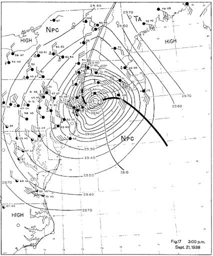
The 1938 New England Hurricane (also referred to as the Great New England Hurricane and the Long Island Express Hurricane) was one of the deadliest and most destructive tropical cyclones to strike Long Island, New York, and New England. The storm formed near the coast of Africa on September 9, becoming a Category 5 hurricane on the Saffir–Simpson hurricane scale, before making landfall as a Category 3 hurricane on Long Island on Wednesday, September 21. It is estimated that the hurricane killed 682 people, damaged or destroyed more than 57,000 homes, and caused property losses estimated at $306 million ($4.7 billion in 2017). Multiple other sources, however, mention that the 1938 hurricane might have really been a more powerful Category 4, having winds similar to Hurricanes Hugo, Harvey, Frederic and Gracie when it ran through Long Island and New England. Also, numerous others estimate the real damage between $347 million and almost $410 million. Damaged trees and buildings w ... [...More Info...] [...Related Items...] OR: [Wikipedia] [Google] [Baidu] |
National Register Of Historic Places
The National Register of Historic Places (NRHP) is the United States federal government's official list of districts, sites, buildings, structures and objects deemed worthy of preservation for their historical significance or "great artistic value". A property listed in the National Register, or located within a National Register Historic District, may qualify for tax incentives derived from the total value of expenses incurred in preserving the property. The passage of the National Historic Preservation Act (NHPA) in 1966 established the National Register and the process for adding properties to it. Of the more than one and a half million properties on the National Register, 95,000 are listed individually. The remainder are contributing resources within historic districts. For most of its history, the National Register has been administered by the National Park Service (NPS), an agency within the U.S. Department of the Interior. Its goals are to help property owners and inte ... [...More Info...] [...Related Items...] OR: [Wikipedia] [Google] [Baidu] |
National Register Of Historic Places Listings In Washington County, Rhode Island
__NOTOC__ This is a list of the National Register of Historic Places listings in Washington County, Rhode Island. This is intended to be a complete list of the properties and districts on the National Register of Historic Places in Washington County, Rhode Island, United States. Latitude and longitude coordinates are provided for many National Register properties and districts; these locations may be seen together in a map. There are 134 properties and districts listed on the National Register in the county, including 4 National Historic Landmarks. Current listings Former listings See also * List of National Historic Landmarks in Rhode Island * National Register of Historic Places listings in Rhode Island References {{Washington County, Rhode Island Washington Washington commonly refers to: * Washington (state), United Stat ... [...More Info...] [...Related Items...] OR: [Wikipedia] [Google] [Baidu] |
Historic Districts In Washington County, Rhode Island
History (derived ) is the systematic study and the documentation of the human activity. The time period of event before the invention of writing systems is considered prehistory. "History" is an umbrella term comprising past events as well as the memory, discovery, collection, organization, presentation, and interpretation of these events. Historians seek knowledge of the past using historical sources such as written documents, oral accounts, art and material artifacts, and ecological markers. History is not complete and still has debatable mysteries. History is also an academic discipline which uses narrative to describe, examine, question, and analyze past events, and investigate their patterns of cause and effect. Historians often debate which narrative best explains an event, as well as the significance of different causes and effects. Historians also debate the nature of history as an end in itself, as well as its usefulness to give perspective on the problems of the p ... [...More Info...] [...Related Items...] OR: [Wikipedia] [Google] [Baidu] |


.jpg)