|
Umerkot District
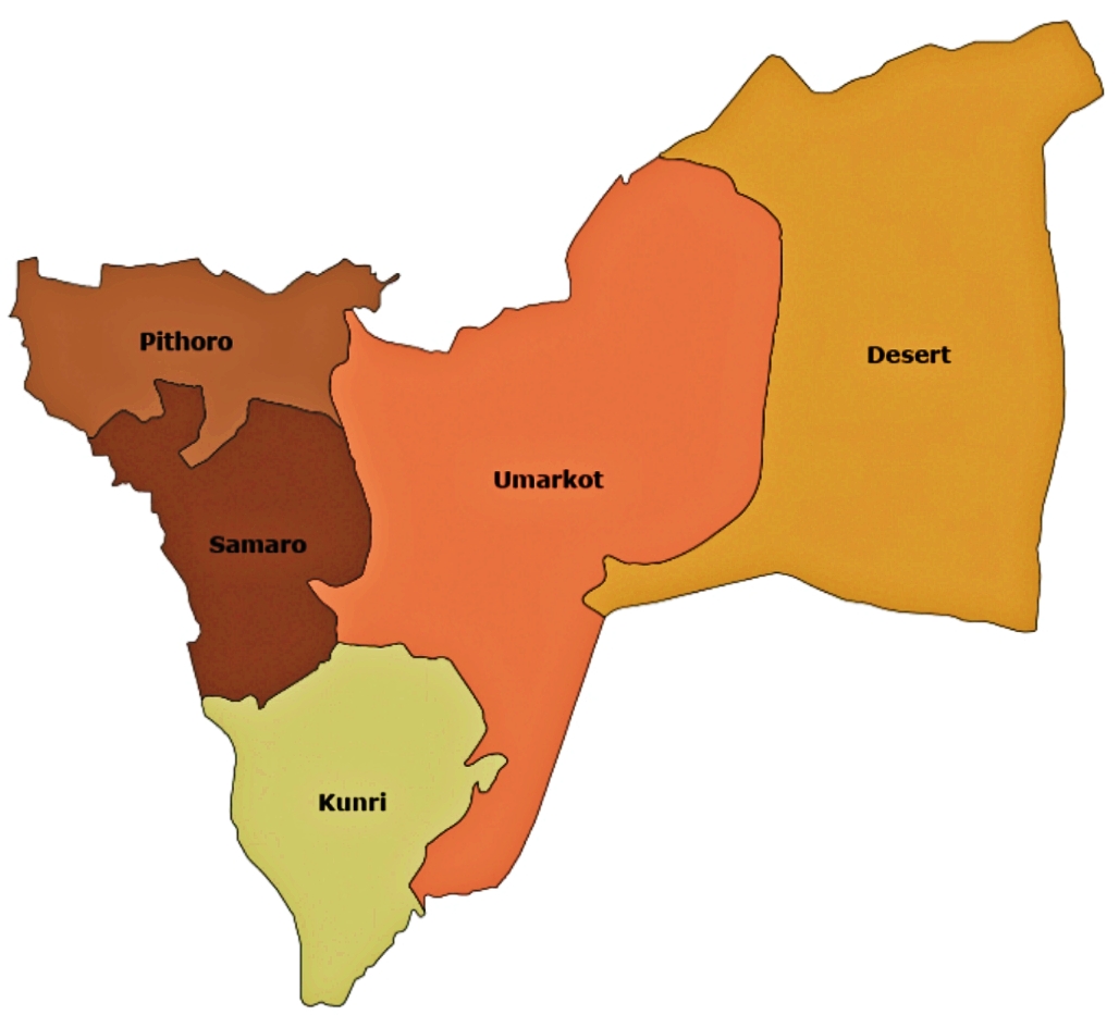
Umerkot District (Dhatki: ØđŲ ØąÚĐŲŲđ / ØđŲ ØąÚŠŲŲ―, sd, ØđŲ ØąÚŠŲŲ― ØķŲØđŲ, ur, ), also known as Amarkot District, is a district in the Sindh province of Pakistan. The city of Umerkot is the capital of the district. Sindhi is the native language of approximately 93.4% of the residents according to the 2017 Pakistan Census. Umerkot is the only non-Muslim majority district in Pakistan, with adherents of Hinduism representing 52.2% of the total population. History Akbar was born in Umerkot Fort when his father Humayun was fleeing from the Suris. After the 1843 invasion by Charles Napier, Sindh was divided into provinces and was assigned a Zamindars, also known as Wadaras, to collect taxes for the British. Administration The district is administratively subdivided into the following Tehsils: * Kunri * Pithoro * Samaro * Umarkot Demographics At the time of the 2017 census, Umerkot district had a population of 1,073,469, of which 556,470 were males and 516,841 females. T ... [...More Info...] [...Related Items...] OR: [Wikipedia] [Google] [Baidu] |
List Of Districts In Sindh
There are thirty districts in the Pakistan province of Sindh. These districts together contain 119 tehsils, 1100 Union Councils and 66,923 human settlements, as per the 1998 census. Each district has a headquarter, often referred to as a capital of the district. Karachi, the capital of Sindh, is the most populous city district, as well as the most densely populated. It was initially a single district, now has been further subdivided into East, West, South, Central, Malir, Keamari and Korangi districts. Currently the Sindh government is planning to divide the Tharparkar district into Tharparkar and Chhachro district, Khairpur district into Khairpur and Thari Mirwah district, Sanghar district into Sanghar and Shahdadpur district. History Colonial Times 1839-1936 In 1839, British Invaded the Sind. On 1843's annexation Sind was merged into Bombay Presidency and form a division of Bombay Presidency. Districts and Divisions were both introduced in Sind as administrative ... [...More Info...] [...Related Items...] OR: [Wikipedia] [Google] [Baidu] |
Charles James Napier
General Sir Charles James Napier, (; 10 August 178229 August 1853) was an officer and veteran of the British Army's Peninsular and 1812 campaigns, and later a Major General of the Bombay Army, during which period he led the military conquest of Sindh, before serving as the Governor of Sindh, and Commander-in-Chief in India. Early life Charles James Napier was the eldest son of Colonel George Napier, and his second wife, Lady Sarah Lennox, with this being the second marriage for both parties. Lady Sarah was the great-granddaughter of King Charles II. Napier was born at the Whitehall Palace in London. When he was only three years old his father took up an administrative post in Dublin, moving his family to live in Celbridge in County Kildare, Ireland, within walking distance of Lady Sarah's sister, Lady Louisa Conolly. His early education was at the local school in Celbridge. At the age of twelve, he joined the 33rd Infantry Regiment of the British Army in January 1794, but qu ... [...More Info...] [...Related Items...] OR: [Wikipedia] [Google] [Baidu] |
Ahmadiyya In Pakistan
Ahmadiyya in Pakistan are members of the Ahmadiyya Muslim Community. The number of Ahmadiyya in the country has been variously estimated to between 0.22% and 2.2% of Pakistan's population. The 1998 Pakistani census states that there are 291,000 (0.22%) Ahmadis in Pakistan. However, the Ahmadiyya Muslim Community has boycotted the census since 1974 which renders official Pakistani figures to be inaccurate. Independent groups have estimated the Pakistani Ahmadiyya population to be somewhere between 2 million and 5 million Ahmadis. However, the 4 million figure is the most quoted figure and is approximately 2.2% of the country. See: * over 2 million: * 3 million: International Federation for Human Rights: ''International Fact-Finding Mission. Freedoms of Expression, of Association and of Assembly in Pakistan.'' Ausgabe 408/2, Januar 2005, S. 61PDF * 3â4 million: Commission on International Religious Freedom: ''Annual Report of the United States Commission on International Religious ... [...More Info...] [...Related Items...] OR: [Wikipedia] [Google] [Baidu] |
Christianity In Pakistan
Christianity (Masihiyt) is the third largest religion in Pakistan, making up about 1.27% of the population according to the 2017 Census. Of these, approximately half are Catholic and half Protestant (primarily Anglican and Presbyterian). A small number of Eastern Orthodox Christians (Masihi) , and Oriental Orthodox Christians (Masihi) also live in Pakistan. Around 75 percent of Pakistan's Christians (Masihi) are rural Punjabi Christians(Masihi) , while some speak Sindhi and Gujarati, Punjabi, Urdu, English, Pashto, Saraiki with the remainder being the upper and middle class Goan Christians(Masihi) and Anglo-Indians. As Punjabi Christians (Masihi)are mainly Hinduism and Sikhism Christiansâdescendants of lower-caste Hindus and Sikhism who converted during the colonial era in Indiaâtheir dire socio-economic conditions facilitate religious discrimination; for example, A HISTORICAL OVERVIEW AND AN ASSESSMENT OF THEIR CURRENT POSITION by Roger Ballard * 1. THE HIS ... [...More Info...] [...Related Items...] OR: [Wikipedia] [Google] [Baidu] |
Hinduism In Pakistan
Hinduism is the second largest religious affiliation in Pakistan after Islam. While Hinduism was one of the dominant faiths in the region a few centuries back, today Hindus account for 2.14% of Pakistan's population or 4.4 million people according to the 2017 Pakistan Census, although Pakistan Hindu Council has claimed that there are 8 million Hindus living in Pakistan, making up 4% of the country's population. The Umerkot district has the highest percentage of Hindu residents in the country at 52.2%, while Tharparkar district has the most Hindus in absolute numbers at 714,698. Before the partition, according to the 1941 census, Hindus constituted 14% of the population in West Pakistan (which is now Pakistan) and 28% of the population in East Pakistan (now Bangladesh). After Pakistan gained independence from the British Raj, 4.7 million of West Pakistan's Hindus and Sikhs moved to India as refugees. And in the first census afterwards in 1951, Hindus made up 1.6% of the total ... [...More Info...] [...Related Items...] OR: [Wikipedia] [Google] [Baidu] |
Islam In Pakistan
Islam is the largest and the state religion of the Islamic Republic of Pakistan. As much as 90% of the population follows Sunni Islam. Most Pakistani Sunni Muslims belong to the Hanafi school of jurisprudence, which is represented by the Barelvi and Deobandi traditions. Pakistan has been called a "global centre for political Islam". Pakistani nationalist narrative is based on the idea that Muslims of the Subcontinent are an independent nation with their own distinctive outlook on life that is different from the rest of subcontinent. Islam in Pakistan existed in communities along the Arab coastal trade routes in Sindh as soon as the religion originated and had gained early acceptance in the Arabian Peninsula. The connection between the Sind and Islam was established by the initial Muslim missions during the Rashidun Caliphate. Al-Hakim ibn Jabalah al-Abdi, who attacked Makran in the year 649 CE, was an Army officer of Caliph Ali. During the Caliphate of Ali, many Hindus ... [...More Info...] [...Related Items...] OR: [Wikipedia] [Google] [Baidu] |
Pakistan Bureau Of Statistics
usman The Pakistan Bureau of Statistics ( ur, , abbreviated as PBS) is a federal agency under the Government of Pakistan commissioned the national statistical services and to provide solid and comprehensive statistical research. Results compiled and produced by the Pakistan Bureau of Statistics helps to better understand Pakistan, its population, resources, economy, society, and culture. PBS is an attached departments of the M/O Planning Development & Special Initiatives. History In 1947, the ''Central Statistical Office'' (CSO) was set up by the government of Prime Minister Liaquat Ali Khan. In 1950, CSO became an attached department of the Economic Affairs Division. In 1972, on the recommendation of IBRD Mission, Prime Minister Zulfikar Ali Bhutto upgraded the Central Statistical Office to a full-fledged government division. In 1981, the bureau was reorganized and its technical wing (CSO) was converted into the then ''Federal Bureau of Statistics''. Former Finance Minis ... [...More Info...] [...Related Items...] OR: [Wikipedia] [Google] [Baidu] |
Umarkot
Umerkot (formerly known as Amarkot) is a city in the Sindh province of Pakistan. The local language is Dhatki, which is one of the Rajasthani languages of the Indo-Aryan language family. It is most closely related to Marwari. Sindhi, Urdu and Punjabi are also understood by the citizens. Etymology The name of the city is named after a local Ruler of Sindh Umer Soomro of the Umar Marvi story which also appears in ''Shah Jo Risalo'' and is one of the popular tragic romances from Sindh. However, the myth of Umer Marvi is believed to have been made up to islamise the history of Amarkot which was named after its original founder, Amar Singh. History Amarkot province was ruled by the Sodha Rajput clan of Hindu Rajputs during the medieval time period. Rana Parshad, the Sodha Rajput ruler of Umarkot, gave refuge to Humayun, the second Mughal Emperor when he was ousted by Sher Shah Suri, and next Mughal Emperor, Akbar was born here. Later on, Akbar brought northwestern India, inc ... [...More Info...] [...Related Items...] OR: [Wikipedia] [Google] [Baidu] |
Samaro
Samaro ( ur, ) is a tehsil in the Sindh province of Pakistan. The town is the headquarters of a tehsil (an administrative subdivision) of Umarkot District. History During British rule the town was renamed Jamesabad (literally "Jamestown" - not to be confused with Jamesabad in Punjab) and was a subdivision of the old Tharparkar District (which had larger boundaries than today.) The taluka of Jamesabad was part of the Bombay Presidency, lying between 24°50' and 25°28' N. and 69°14' and 69°35âēE and had an area of . According to the 1901 census the population was 24,038 - an increase almost 5,000 since the 1891 (19,208). The density of 48 persons per square mile was considerably above the District average. The Taluka contained 184 villages, of which Jamesabad was headquarters. The land revenue and cesses 1903-4 amounted to 370,000. Now Samaro in District Umerkot. Samaro road is 7 km northeast from Samaro city it also developing area in Samaro.Rahu Abad Rahu Abad ... [...More Info...] [...Related Items...] OR: [Wikipedia] [Google] [Baidu] |
Kunri
Kunri is a tehsil and town located in the Umarkot District, Sindh province in southern Pakistan. It is located about east of Karachi Karachi (; ur, ; ; ) is the most populous city in Pakistan and 12th most populous city in the world, with a population of over 20 million. It is situated at the southern tip of the country along the Arabian Sea coast. It is the former cap .... Notes References * *Linda S. Walbridge. ''The Christians of Pakistan: the passion of Bishop John Joseph.'' Routledge. 1st edition. 19 September 2002. {{coord missing, Sindh Populated places in Umerkot District Talukas of Sindh ... [...More Info...] [...Related Items...] OR: [Wikipedia] [Google] [Baidu] |
List Of Tehsils Of Sindh
In Pakistan, a tehsil or (taluka) is an administrative sub-division of a District. Those are sub-divided into union councils. Here is a list of all the tehsil of Sindh Province. Banbhore Division Badin District # Badin Tehsil # Khoski Tehsil # Matli Tehsil # Shaheed Fazil Rahu Tehsil # Talhar Tehsil # Tando Bago Tehsil Sujawal District # Jati Tehsil # Kharo Chan Tehsil # Mirpur Bathoro Tehsil # Shah Bandar Tehsil # Sujawal Tehsil Thatta District # Ghorabari Tehsil # Keti Bunder # Mirpur Sakro Tehsil # Thatta Tehsil Hyderabad Division Dadu District # Dadu Tehsil # Johi Tehsil # Khairpur Nathan Shah Tehsil # Mehar Tehsil Hyderabad District # Hyderabad City Tehsil # Hyderabad Tehsil # Latifabad Tehsil # Qasimabad Tehsil Jamshoro District # Jamshoro Tehsil # Sehwan Tehsil # Kotri Tehsil # Manjhand Tehsil # Thana Bulla Khan Tehsil Matiari District # Hala Tehsil # Matiari Tehsil # Saeedabad Tehsil Tando Allahyar District Tando Allahyar District ( sd, Ų ... [...More Info...] [...Related Items...] OR: [Wikipedia] [Google] [Baidu] |


