|
Tyndalls Park
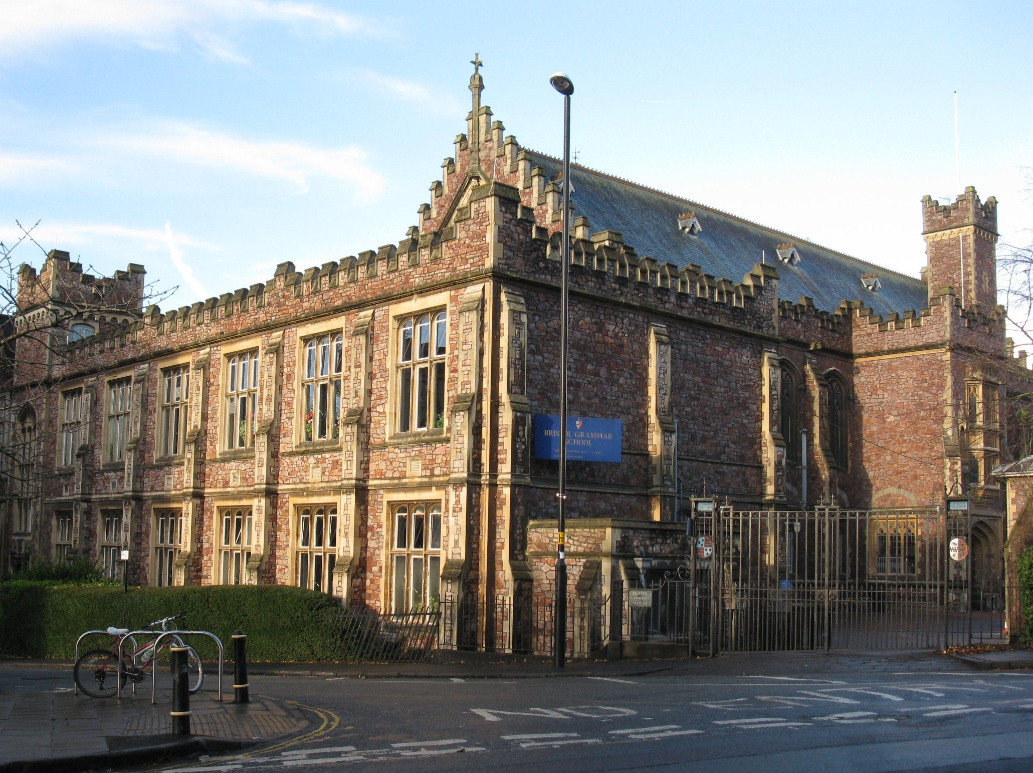
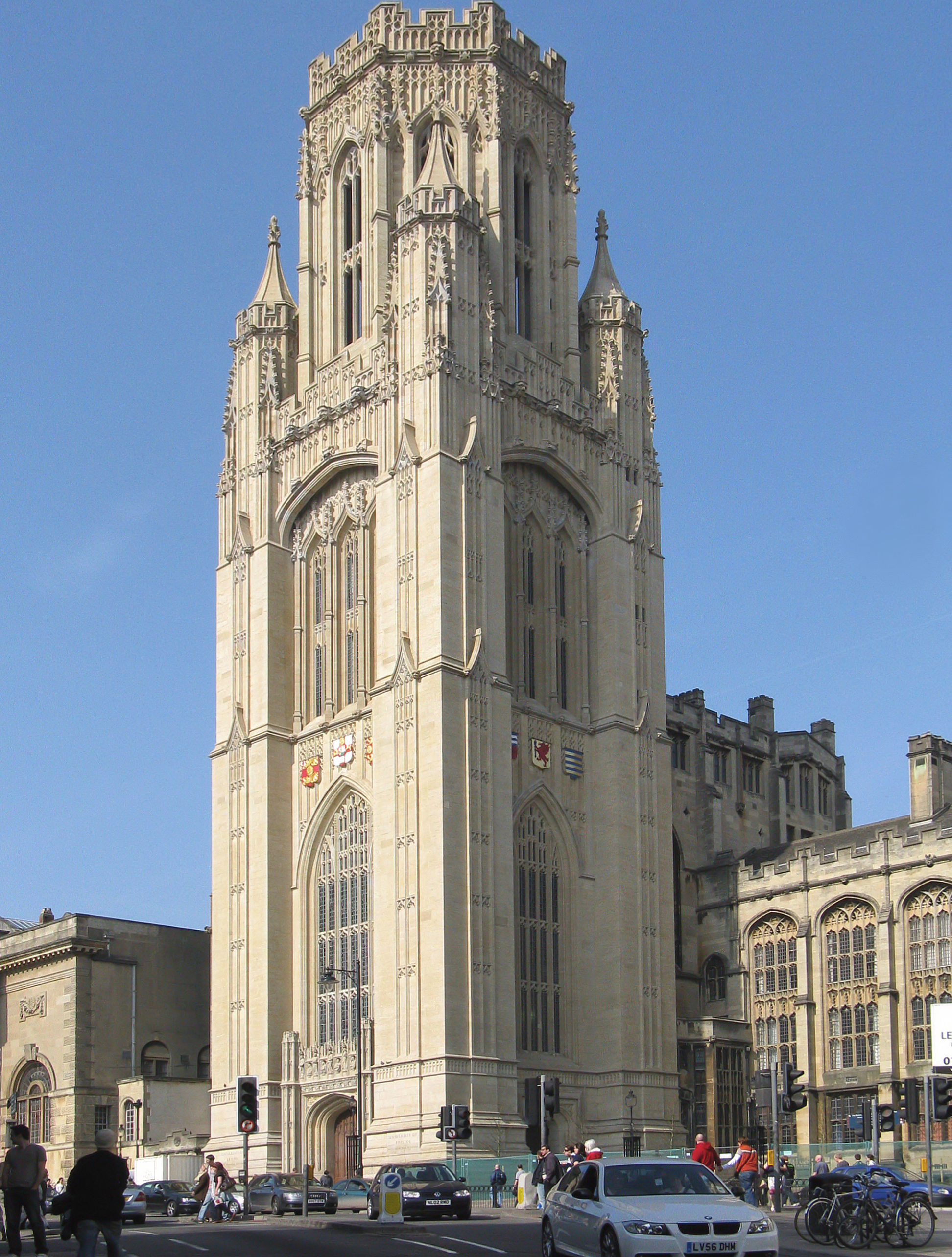
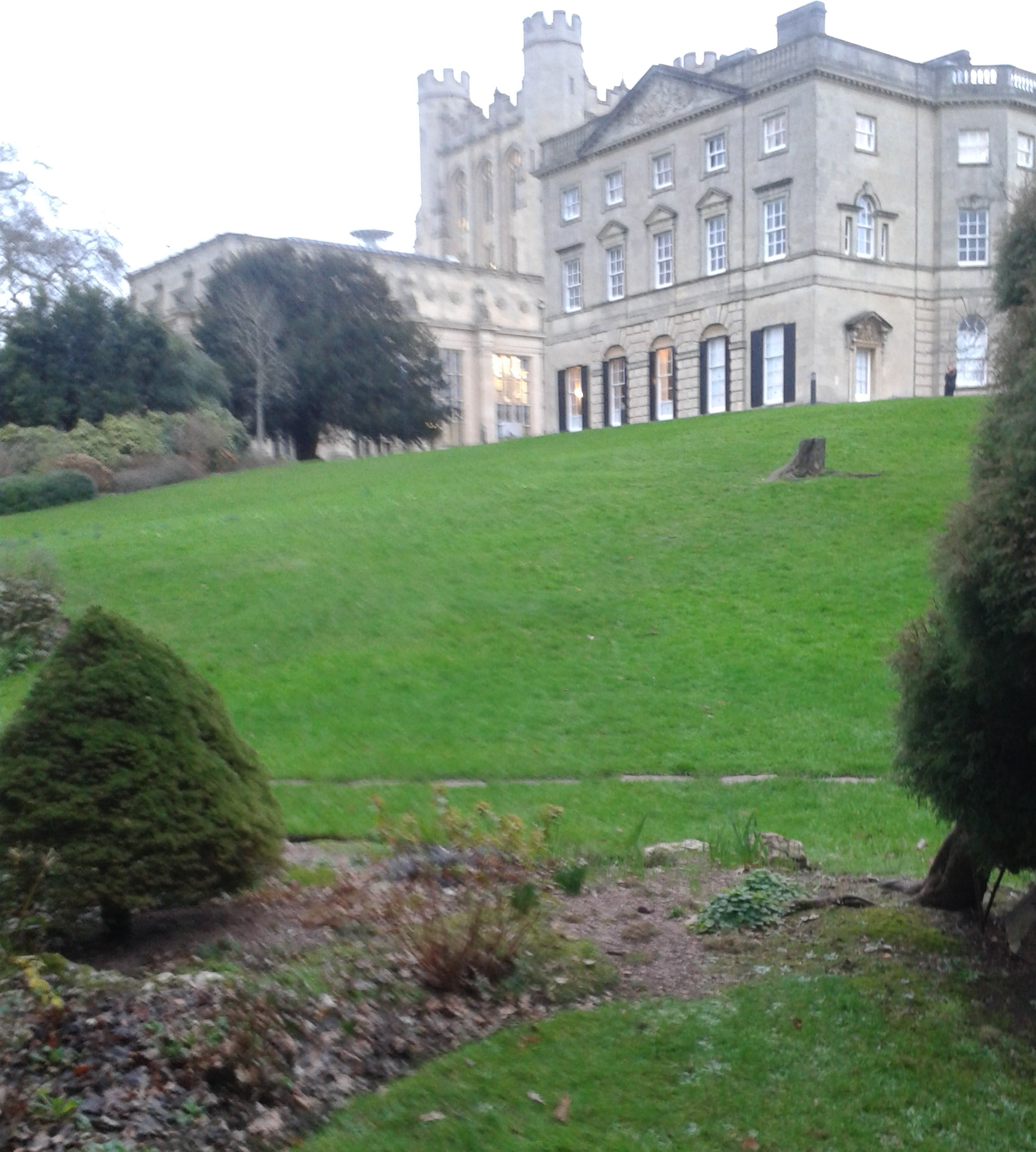
Tyndall's Park is an area of central Bristol, England. It lies north of Park Row and Queen's Road, east of Whiteladies Road and west of St Michael's Hill, between the districts of Clifton, Cotham and Kingsdown. It includes the campus of Bristol Grammar School, and many of the buildings of the University of Bristol. The area is named after Thomas Tyndall, a Bristol merchant and investor in the slave trade who between 1753 and 1767 bought a number of fields which then existed in the area and turned them into an ornamental park. He built a stately house on the crest of the hill, on the site of a Civil War fortification, and named it Fort Royal (now known as Royal Fort House). In 1799 Tyndall's son Colonel Thomas Tyndall employed Humphrey Repton to landscape the gardens. In 1825 and 1833, two roads (Aberdeen Road and West Park) were built in the north western corner of the park, and developed for housing. In 1852 the Tyndalls began selling off the remainder of the western half of ... [...More Info...] [...Related Items...] OR: [Wikipedia] [Google] [Baidu] |
Bristol
Bristol () is a city, ceremonial county and unitary authority in England. Situated on the River Avon, it is bordered by the ceremonial counties of Gloucestershire to the north and Somerset to the south. Bristol is the most populous city in South West England. The wider Bristol Built-up Area is the eleventh most populous urban area in the United Kingdom. Iron Age hillforts and Roman villas were built near the confluence of the rivers Frome and Avon. Around the beginning of the 11th century, the settlement was known as (Old English: 'the place at the bridge'). Bristol received a royal charter in 1155 and was historically divided between Gloucestershire and Somerset until 1373 when it became a county corporate. From the 13th to the 18th century, Bristol was among the top three English cities, after London, in tax receipts. A major port, Bristol was a starting place for early voyages of exploration to the New World. On a ship out of Bristol in 1497, John Cabot, a Venetia ... [...More Info...] [...Related Items...] OR: [Wikipedia] [Google] [Baidu] |
Bristol West (UK Parliament Constituency)
Bristol West is a borough constituency represented in the House of Commons of the United Kingdom, House of Commons of the Parliament of the United Kingdom since 2015 by Thangam Debbonaire of the Labour Party (UK), Labour Party. It mostly covers the central and western parts of Bristol. Constituency profile More urban since boundary changes in 2010, the seat retains a high proportion of the city's most garden-rich, grandest houses and landscaped civic parks in affluent suburbs such as Clifton, Bristol, Clifton and Redland, Bristol, Redland. Many of the townhouses in Bristol were subdivided in the latter half of the 20th century, during which time the size of the University of Bristol increased (the city's largest single independent employer which is chiefly in the seat). The seat also includes poorer areas such as Lawrence Hill, Bristol, Lawrence Hill and Easton, Bristol, Easton. Boundaries 1885–1918: The Municipal Borough of Bristol wards: Clifton, St Augustine's, St Michael' ... [...More Info...] [...Related Items...] OR: [Wikipedia] [Google] [Baidu] |
Whiteladies Road
Whiteladies Road is a main road in Bristol, England. It runs north from the Victoria Rooms to Durdham Down, and separates Clifton on the west side from Redland and Cotham on the east. It forms part of the A4018. Significant buildings on Whiteladies Road include (from south to north): * Broadcasting House, offices and studios of the British Broadcasting Corporation; * the Whiteladies Picture House; * Clifton Down railway station; *Tyndale Baptist Church. Historically, the top half as far as Cotham Hill was the main easterly route into Bristol and the through route towards London and Bath from New Passage where there was a ferry from Wales. Later it was also the route into Bristol and onwards from the Port at Avonmouth. The road was extended in the early 1800s with the building of the second half of the street, and the route continued down Park Street. The main route from Avonmouth was superseded by the building of The Portway in the 1920s. Most of the traffic from Wales ... [...More Info...] [...Related Items...] OR: [Wikipedia] [Google] [Baidu] |
Clifton, Bristol
Clifton is both a suburb of Bristol, England, and the name of one of the city's thirty-five council wards. The Clifton ward also includes the areas of Cliftonwood and Hotwells. The eastern part of the suburb lies within the ward of Clifton Down. Notable places in Clifton include Clifton Suspension Bridge, Clifton Cathedral, Clifton College, The Clifton Club, Clifton High School, Bristol, Goldney Hall and Clifton Down. Clifton Clifton is an inner suburb of the English port city of Bristol. Clifton was recorded in the Domesday book as ''Clistone'', the name of the village denoting a 'hillside settlement' and referring to its position on a steep hill. Until 1898 Clifton St Andrew was a separate civil parish within the Municipal Borough of Bristol. Various sub-districts of Clifton exist, including Whiteladies Road, an important shopping district to the east, and Clifton Village, a smaller shopping area near the Avon Gorge to the west. Although the suburb has no formal boundar ... [...More Info...] [...Related Items...] OR: [Wikipedia] [Google] [Baidu] |
Cotham, Bristol
Cotham is an area of Bristol, England, about 1 mile north of the city centre. It is an affluent, leafy, inner city suburb situated north of the neighbourhoods of Kingsdown and St Paul’s and sandwiched between Gloucester Road (A38) to the east, and Hampton Road to the west. Cotham is closely related to the neighbourhood of Redland to the north, with the Severn Beach Railway Line broadly marking where Cotham ends and Redland begins, though Ward boundaries show Cotham extending to Redland Road. Redland’s boundaries is usually taken to extend to Coldharbour Road. To the north lies Bishopston and Westbury Park, and Durdham Down to the west. Cotham and Redland together make up the Bristol City Council's Cotham and Redland Conservation Area. It is also the name of a council ward of the city, which also includes other areas. The suburb Cotham is characterised by its individually developed urban streets, dominated by a high-quality victorian townscape, in conjunction with i ... [...More Info...] [...Related Items...] OR: [Wikipedia] [Google] [Baidu] |
Kingsdown, Bristol
Kingsdown is an area of Bristol, located on high ground immediately north of the city centre and south of Cotham. It lies within the Cotham council ward. Kingsdown remained rural until the 18th century, but around 1737 land on the southern slope was laid out to become Bristol's first planned suburb. The area was fully developed over the remainder of the century, and as a result Kingsdown has a mostly Georgian character. There are more than 200 listed building In the United Kingdom, a listed building or listed structure is one that has been placed on one of the four statutory lists maintained by Historic England in England, Historic Environment Scotland in Scotland, in Wales, and the Northern Irel ...s, and much of the area has been a conservation area since 1973. St Matthew's Church was built on the northern side of Kingsdown between 1833 and 1835. References Areas of Bristol {{Bristol-geo-stub ... [...More Info...] [...Related Items...] OR: [Wikipedia] [Google] [Baidu] |
Bristol Grammar School
Bristol Grammar School (BGS) is a 4–18 mixed, independent day school in Bristol, England. It was founded in 1532 by Royal Charter for the teaching of 'good manners and literature', endowed by wealthy Bristol merchants Robert and Nicholas Thorne. The school flourished in the early 20th century under headmaster Sir Cyril Norwood (1906–1916), embodying "the ideals and experiences of a leading public school". Norwood went on to serve as the master at Marlborough College and Harrow, and as president of St John's College, Oxford. The headmaster, Jaideep Barot MA MSc, is a member of the Headmasters' and Headmistresses' Conference (HMC) and was appointed in September 2018. The school was first cited in the ''Public Schools Year Book'' in 1907, and former headmaster John Mackay (1960–1975) served as the chairman of the HMC in 1970. Founded as an all-boys school, Bristol Grammar is now fully co-educational having first admitted girls in 1980. The school counts among its alumni prom ... [...More Info...] [...Related Items...] OR: [Wikipedia] [Google] [Baidu] |
University Of Bristol
, mottoeng = earningpromotes one's innate power (from Horace, ''Ode 4.4'') , established = 1595 – Merchant Venturers School1876 – University College, Bristol1909 – received royal charter , type = Public red brick research university , endowment = £91.3 million (2021) , budget = £752.0 million (2020–21) , chancellor = Paul Nurse , vice_chancellor = Professor Evelyn Welch , head_label = Visitor , head = Rt Hon. Penny Mordaunt MP , academic_staff = 3,385 (2020) , students = () , undergrad = () , postgrad = () , city = Bristol , country = England , coor = , campus = Urban , free_label = Students' Union , free = University of Bristol Union , colours = ... [...More Info...] [...Related Items...] OR: [Wikipedia] [Google] [Baidu] |
Thomas Tyndall
Thomas Tyndall (bapt. 26 March 1723 – 17 April 1794) was an English merchant and banker from Bristol with extensive slave trade connections. Tyndall was the son of Onesiphorus Tyndall and Elizabeth Cowles and baptised in the Unitarian church. Tyndall's father had been a founding partner in the Old Bank in Bristol, and Tyndall inherited a considerable legacy on his father's death in 1757. Tyndall also succeeded his father as a partner in the bank. Tyndall's uncle William Tyndall was a slave factor in Jamaica, and owned a plantation with his business partner Richard Assheton. Tyndall commissioned the Royal Fort House in Tyndalls Park in Bristol, now part of the University of Bristol , mottoeng = earningpromotes one's innate power (from Horace, ''Ode 4.4'') , established = 1595 – Merchant Venturers School1876 – University College, Bristol1909 – received royal charter , type .... The house was built around 1767. Tyndall's ... [...More Info...] [...Related Items...] OR: [Wikipedia] [Google] [Baidu] |
Atlantic Slave Trade
The Atlantic slave trade, transatlantic slave trade, or Euro-American slave trade involved the transportation by slave traders of enslaved African people, mainly to the Americas. The slave trade regularly used the triangular trade route and its Middle Passage, and existed from the 16th to the 19th centuries. The vast majority of those who were transported in the transatlantic slave trade were people from Central and West Africa that had been sold by other West Africans to Western European slave traders,Thornton, p. 112. while others had been captured directly by the slave traders in coastal raids; Europeans gathered and imprisoned the enslaved at forts on the African coast and then brought them to the Americas. Except for the Portuguese, European slave traders generally did not participate in the raids because life expectancy for Europeans in sub-Saharan Africa was less than one year during the period of the slave trade (which was prior to the widespread availability of quini ... [...More Info...] [...Related Items...] OR: [Wikipedia] [Google] [Baidu] |
English Civil War
The English Civil War (1642–1651) was a series of civil wars and political machinations between Parliamentarians (" Roundheads") and Royalists led by Charles I ("Cavaliers"), mainly over the manner of England's governance and issues of religious freedom. It was part of the wider Wars of the Three Kingdoms. The first (1642–1646) and second (1648–1649) wars pitted the supporters of King Charles I against the supporters of the Long Parliament, while the third (1649–1651) saw fighting between supporters of King Charles II and supporters of the Rump Parliament. The wars also involved the Scottish Covenanters and Irish Confederates. The war ended with Parliamentarian victory at the Battle of Worcester on 3 September 1651. Unlike other civil wars in England, which were mainly fought over who should rule, these conflicts were also concerned with how the three Kingdoms of England, Scotland and Ireland should be governed. The outcome was threefold: the trial of and ... [...More Info...] [...Related Items...] OR: [Wikipedia] [Google] [Baidu] |
Royal Fort House
The Royal Fort House is a historic house in Tyndalls Park, Bristol. The building currently houses the University of Bristol's Faculty of Science offices, the Brigstow Institute, Elizabeth Blackwell Institute for Health Research, the Cabot Institute and the Jean Golding Institute for data-intensive research. The house was built for Thomas Tyndall KCB, in the 18th century, on the site of bastions which were fought over during the English Civil War and demolished in 1655. The Baroque, Palladian and Rococo styles of architecture are because of the work of three different architects: James Bridges, Thomas Paty, John Wallis. The garden was laid out by Humphry Repton around 1800. History The house was constructed on the site of a Civil War fortification, which had two bastions on the inside of the lines and three on the outside. It was the strongest part of the defences of Bristol, designed by Dutch military engineer Sir Bernard de Gomme. It was one of the few purpose-built defen ... [...More Info...] [...Related Items...] OR: [Wikipedia] [Google] [Baidu] |

.jpg)


.jpg)

