|
Twin Bridges Trailhead
{{coord, 38.811687, N, 120.123634, W, display=title The Twin Bridges trailhead or Pyramid Creek trailhead is located off U.S. Route 50 a couple miles east of Strawberry, California, west of Echo Pass. Some of the destinations most accessed by the trailhead are Horsetail Falls (1 mi) and Ropi Lake (1.75 mi) or Lake of the Woods (3 mi) as well as the rest of the Desolation Wilderness The Desolation Wilderness is a federally protected wilderness area in the Eldorado National Forest and Lake Tahoe Basin Management Unit, in El Dorado County, California. The crest of the Sierra Nevada runs through it, just west of Lake Tahoe. H .... This trailhead offers a commonly accepted route to the summit of Pyramid Peak, although the most popular trailhead to Pyramid Peak is an unmarked trailhead at Rocky Canyon (which is about a mile west of the Pyramid Creek Trailhead). In winter only the first mile is easily accessible as there is very steep exposed terrain after the falls. ... [...More Info...] [...Related Items...] OR: [Wikipedia] [Google] [Baidu] |
Strawberry, El Dorado County, California
Strawberry is a small unincorporated community on the South Fork American River, south-southwest of Pyramid Peak, along U.S. Route 50 in the foothills of the Sierra Nevada. The sign on the highway reads population 50. The town became a popular resort in the 1850s, and a station along the Central Overland Pony Express between Yank's Station and Webster's, Sugar Loaf House Station. It was along the Lincoln Highway Sierra Nevada Southern Route by 1916. The site is now registered as California Historical Landmark A California Historical Landmark (CHL) is a building, structure, site, or place in California that has been determined to have statewide historical landmark significance. Criteria Historical significance is determined by meeting at least one of ... #707. Strawberry is also the home of Lovers Leap climbing area. References Pony Express stations Unincorporated communities in the Sacramento metropolitan area Unincorporated communities in California Uninc ... [...More Info...] [...Related Items...] OR: [Wikipedia] [Google] [Baidu] |
Echo Summit
Echo Summit is a mountain pass over the Sierra Nevada in the western United States, located in eastern El Dorado County, California. At above sea level, it is the highest point on U.S. Route 50 in California, which traverses it at postmile 66.48 between Twin Bridges and Meyers, south of Lake Tahoe. The "Sierra Nevada Southern Route" (aka the "Pioneer Route") of the Lincoln Highway, the first road across the United States, was routed over nearby Johnson Pass in 1913. The current alignment over Echo Summit was constructed between 1936 and 1939. The "Sierra Nevada Northern Route" of the Lincoln Highway went over Donner Pass. Echo Summit is a trailhead for the Pacific Crest National Scenic Trail.1968 Olympians Return to Echo Summit ... [...More Info...] [...Related Items...] OR: [Wikipedia] [Google] [Baidu] |
Horsetail Falls (California)
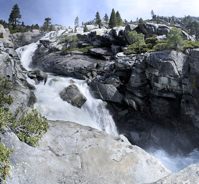
Horsetail Falls is a waterfall in the Sierra Nevada mountain range, to the west of Lake Tahoe in the Desolation Wilderness of El Dorado County, California, United States. It falls in stages for . It can be reached by hiking north out of the Twin Bridges trailhead on U.S. Route 50 U.S. Route 50 or U.S. Highway 50 (US 50) is a major east–west route of the U.S. Highway system, stretching from Interstate 80 (I-80) in West Sacramento, California, to Maryland Route 528 (MD 528) in Ocean City, Maryland, on the Atlanti .... There is a forest service parking area designated to the area. It is located at . References External links Routes, Waypoints, and Maps Lake Tahoe Waterfalls of the Sierra Nevada (United States) Waterfalls of California Landforms of El Dorado County, California Eldorado National Forest Tourist attractions in El Dorado County, California {{ElDoradoCountyCA-geo-stub ... [...More Info...] [...Related Items...] OR: [Wikipedia] [Google] [Baidu] |
Lake Of The Woods (California)
The Lake of the Woods is a backcountry glacial lake in the Desolation Wilderness of the Eldorado National Forest, southwest of Lake Tahoe, in El Dorado County, California. It lies just southeast of Lake Aloha. The lake is accessible by hiking west out of the Glen Alpine Springs Trailhead, Echo Lake (California) Trailhead or north out of the Twin Bridges Trailhead. The lake is known to contain Rainbow Trout and Brook Trout. See also * List of lakes in California There are more than 3,000 named lakes, reservoirs, and dry lakes in the U.S. state of California. Largest lakes In terms of area covered, the largest lake in California is the Salton Sea, a lake formed in 1905 which is now saline. It occupies ... References * Lakes of the Desolation Wilderness Lakes of the Sierra Nevada (United States) Lakes of El Dorado County, California Glacial lakes of the United States Eldorado National Forest Lakes of California Lake Tahoe Lakes of Northern California { ... [...More Info...] [...Related Items...] OR: [Wikipedia] [Google] [Baidu] |
Desolation Wilderness
The Desolation Wilderness is a federally protected wilderness area in the Eldorado National Forest and Lake Tahoe Basin Management Unit, in El Dorado County, California. The crest of the Sierra Nevada runs through it, just west of Lake Tahoe. History Before European settlement in the mid-19th century, there is evidence this area was used by the Washoe. After, it was known at times as "Devil's Valley," and most often used for cattle grazing. By the end of that century, the first formal step to limiting its development when it was made a Forest Reserve, managed first by the General Land Office, and later, by the US Forest Service. It was set aside as the Desolation Valley Primitive Area in 1931 with an area of . In 1969, it became the Desolation Wilderness after the passage of the Wilderness Act of 1964.Godfrey, Anthony. ''The Ever-Changing View-A History of the National Forests in California''. USDA Forest Service Publishers, 2005. p. 445. Access Desolation is a popular ba ... [...More Info...] [...Related Items...] OR: [Wikipedia] [Google] [Baidu] |
Pyramid Peak (California)
Pyramid Peak is a mountain in the California's Sierra Nevada in the Crystal Range to the west of Lake Tahoe. It is the highest point in the Desolation Wilderness The Desolation Wilderness is a federally protected wilderness area in the Eldorado National Forest and Lake Tahoe Basin Management Unit, in El Dorado County, California. The crest of the Sierra Nevada runs through it, just west of Lake Tahoe. .... With an elevation gain of almost , the Rocky Canyon route is the mountain's most popular approach although it is very arduous. To the east, at the base of the peak, lies Pyramid Lake. References External links * * Alpine Ski Tours - Lake Tahoe: Southwest Topographic Map Mountains of the Desolation Wilderness North American 3000 m summits Mountains of El Dorado County, California {{ElDoradoCountyCA-geo-stub ... [...More Info...] [...Related Items...] OR: [Wikipedia] [Google] [Baidu] |
Lake Tahoe
Lake Tahoe (; was, Dáʔaw, meaning "the lake") is a Fresh water, freshwater lake in the Sierra Nevada (U.S.), Sierra Nevada of the United States. Lying at , it straddles the state line between California and Nevada, west of Carson City, Nevada, Carson City. Lake Tahoe is the largest alpine lake in North America, and at it trails only the five Great Lakes as the List of lakes by volume, largest by volume in the United States. Its depth is , making it the List of lakes by depth, second deepest in the United States after Crater Lake in Oregon (). The lake was formed about two million years ago as part of the Lake Tahoe Basin, and its modern extent was shaped during the Quaternary glaciation, ice ages. It is known for the clarity of its water and the panorama of surrounding mountains on all sides. The area surrounding the lake is also referred to as Lake Tahoe, or simply Tahoe. More than 75% of the lake's Drainage basin, watershed is United States National Forest, national forest ... [...More Info...] [...Related Items...] OR: [Wikipedia] [Google] [Baidu] |
Sierra Nevada (United States)
The Sierra Nevada () is a mountain range in the Western United States, between the Central Valley of California and the Great Basin. The vast majority of the range lies in the state of California, although the Carson Range spur lies primarily in Nevada. The Sierra Nevada is part of the American Cordillera, an almost continuous chain of mountain ranges that forms the western "backbone" of the Americas. The Sierra runs north-south and its width ranges from to across east–west. Notable features include General Sherman, the largest tree in the world by volume; Lake Tahoe, the largest alpine lake in North America; Mount Whitney at , the highest point in the contiguous United States; and Yosemite Valley sculpted by glaciers from one-hundred-million-year-old granite, containing high waterfalls. The Sierra is home to three national parks, twenty wilderness areas, and two national monuments. These areas include Yosemite, Sequoia, and Kings Canyon National Parks; and Devils Postpi ... [...More Info...] [...Related Items...] OR: [Wikipedia] [Google] [Baidu] |


