|
Turmequé
Turmequé is a town and municipality in the Colombian Department of Boyacá, part of the subregion of the Márquez Province. Turmequé is located at northeast from the capital Bogotá. The municipality borders Ventaquemada in the west, in the east Úmbita, in the north Nuevo Colón and in the south the municipality Villapinzón of the department of Cundinamarca. Official website Turmequé - accessed 03-05-2016 History Turmequé was an important center for the who inhabited the before the arrival of th ...[...More Info...] [...Related Items...] OR: [Wikipedia] [Google] [Baidu] |
Muisca Confederation
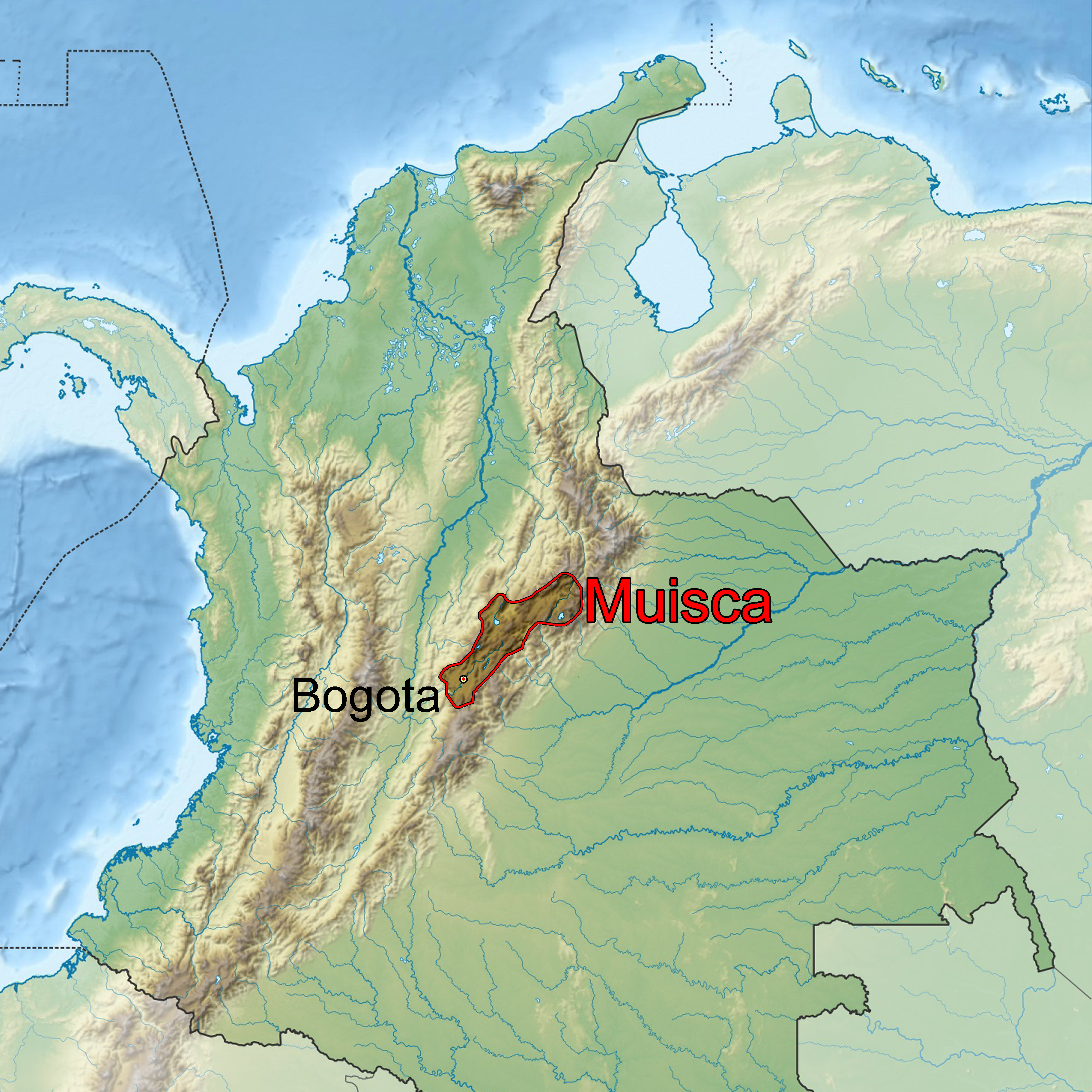
The Muisca Confederation was a loose confederation of different Muisca rulers (''zaques'', ''zipas'', '' iraca'', and ''tundama'') in the central Andean highlands of present-day Colombia before the Spanish conquest of northern South America. The area, presently called Altiplano Cundiboyacense, comprised the current departments of Boyacá, Cundinamarca and minor parts of Santander. According to some Muisca scholars the Muisca Confederation was one of the best-organized confederations of tribes on the South American continent. Modern anthropologists, such as Jorge Gamboa Mendoza, attribute the present-day knowledge about the confederation and its organization more to a reflection by Spanish chroniclers who predominantly wrote about it a century or more after the Muisca were conquered and proposed the idea of a loose collection of different people with slightly different languages and backgrounds.Gamboa Mendoza, 2016 Geography Climate Muisca Confederation In the time ... [...More Info...] [...Related Items...] OR: [Wikipedia] [Google] [Baidu] |
Chaquén
Chaquén was the god of sports and fertility in the religion of the Muisca. The Muisca and their confederation were one of the four advanced civilizations of the Americas and as they were warriors, sports was very important to train the fighters for wars, mainly fought between the ''zipazgo'' and the '' zacazgo'' but also against other indigenous peoples as the Panches, Muzos and others. When the Spanish arrived in the highlands of central Colombia, the Altiplano Cundiboyacense, they encountered resistance of the guecha warriors, trained by Chaquén. Description Chaquén flew over the boundaries of the sowing fields of the rich agriculture of the Muisca. During the contests and festivities of the Muisca people Chaquén manifestated himself. 17th century chronicler Pedro Simón said about Chaquén: "The Muisca organized races on their holidays where the vassals of the '' caciques'' would compete in many aspects; dances with new inventions and a lot of feathers, flutes, horn ... [...More Info...] [...Related Items...] OR: [Wikipedia] [Google] [Baidu] |
Spanish Conquest Of The Muisca
The Spanish conquest of the Muisca took place from 1537 to 1540. The Muisca were the inhabitants of the central Andean highlands of Colombia before the arrival of the Spanish conquistadors. They were organised in a loose confederation of different rulers; the '' psihipqua'' of Muyquytá, with his headquarters in Funza, the '' hoa'' of Hunza, the ''iraca'' of the sacred City of the Sun Sugamuxi, the Tundama of Tundama, and several other independent ''caciques''. The most important rulers at the time of the conquest were ''psihipqua'' Tisquesusa, ''hoa'' Eucaneme, ''iraca'' Sugamuxi and Tundama in the northernmost portion of their territories. The Muisca were organised in small communities of circular enclosures (''ca'' in their language Muysccubbun; literally "language of the people"), with a central square where the '' bohĂo'' of the ''cacique'' was located. They were called "Salt People" because of their extraction of salt in various locations throughout their territories, ma ... [...More Info...] [...Related Items...] OR: [Wikipedia] [Google] [Baidu] |
Márquez Province
The Márquez Province is a province of Boyacá Department, Colombia. The province is formed by 10 municipalities. Municipalities Boyacá • Ciénaga • Jenesano • Nuevo Colón • Ramiriquà Ramiriquà is a town and municipality in the Colombian Department of Boyacá, part of the subregion of the Márquez Province. Ramiriquà borders the department capital Tunja in the north, in the south Chinavita and Zetaquirá, in the east Ron ... • Rondón • Tibaná • Turmequé • Úmbita • Viracachá References External links Boyaca Info; Provinces of Boyaca Provinces of Boyacá Department {{Boyacá-geo-stub ... [...More Info...] [...Related Items...] OR: [Wikipedia] [Google] [Baidu] |
Tunja
Tunja () is a city on the Eastern Ranges of the Colombian Andes, in the region known as the Altiplano Cundiboyacense, 130 km northeast of Bogotá. In 2018 it had a population of 172,548 inhabitants. It is the capital of Boyacá department and the Central Boyacá Province. Tunja is an important educational centre of well-known universities. In the time before the Spanish conquest of the Muisca, there was an indigenous settlement, called Hunza, seat of the ''hoa'' Eucaneme, conquered by the Spanish conquistadors on August 20, 1537. The Spanish city was founded by captain Gonzalo Suárez Rendón on August 6, 1539, exactly one year after the capital Santafé de Bogotá. The city hosts the most remaining Muisca architecture: Hunzahúa Well, Goranchacha Temple and Cojines del Zaque. Tunja is a tourist destination, especially for religious colonial architecture, with the Casa Fundador Gonzalo Suárez Rendón as oldest remnant. In addition to its religious and historical sites it ... [...More Info...] [...Related Items...] OR: [Wikipedia] [Google] [Baidu] |
Zaque
When the Spanish arrived in the central Colombian highlands, the region was organized into the Muisca Confederation, which had two rulers; the ''zipa'' was the ruler of the southern part and based in Muyquytá. The ''hoa'' was the ruler of the northern area and based in Hunza, known today as Tunja. Organization ''Psihipqua'' and ''hoa'' were the titles given to these rulers of the ancient confederation. Neither exercised absolute power, not rigid or strict control over those to whom they owed their power, so that they can be considered kings. However, these positions of power were of great honor and were surrounded by a rather elaborate ceremony. The position of the ''psihipqua'' was such that not even the members of the nobility dared to look him in the face, and it is said if the ''psihipqua'' needed to spit, someone would hold out a piece of rich cloth for him to spit on, because it would be sacrilegious for anything so precious as his saliva to touch the ground. Whoever hel ... [...More Info...] [...Related Items...] OR: [Wikipedia] [Google] [Baidu] |
VillapinzĂłn
VillapinzĂłn is a municipality and town of Colombia in the Almeidas Province, part of the department of Cundinamarca. The urban centre is situated at an elevation of on the Altiplano Cundiboyacense, at a distance of from the capital Bogotá. VillapinzĂłn borders Ventaquemada ( Boyacá) and Lenguazaque in the north, Chocontá, Tibiritá and La Capilla in the south, Chocontá and Lenguazaque in the west and Ventaquemada, TurmequĂ© and Ăšmbita in the east. The municipality is located in the uppermost part of the Bogotá River Basin; the origin of the river is within the municipality VillapinzĂłn at an elevation of . Etymology VillapinzĂłn was named Hato Viejo for most of its history. In 1903, the name was changed to "PinzĂłn", honouring PrĂłspero PinzĂłn Romero, commander of the army and Minister of War of Colombia under Colombian president JosĂ© Manuel MarroquĂn Jose Manuel Cayetano MarroquĂn Ricaurte (August 6, 1827 – September 19, 1908) was a Colombian political ... [...More Info...] [...Related Items...] OR: [Wikipedia] [Google] [Baidu] |
Tejo (sport)
Tejo (), also known, to a lesser degree, as turmequé (), is a traditional throwing sport in Colombia. It is characteristic for its use of small targets containing gunpowder, which explode on impact. History There is not one widely accepted theory on the origins of tejo. In fact, it is believed that many of the current theories circulating on the internet might be fictitious and a result of "word of mouth" and speculation. It is, however, widely accepted that the sport has origins in native aboriginals from the center of Colombia, where it might have been played in a similar form. Another theory presented by the Colombian government on its website describes the game as having originated more than 500 years ago. In this theory, presented by one of the most important authorities in the country, the sport was played by native people that would use a golden disc called ''zepguagoscua''. This, however, is refuted in other sources as a word with sounds not existent in dictionarie ... [...More Info...] [...Related Items...] OR: [Wikipedia] [Google] [Baidu] |
Muisca People
The Muisca (also called Chibcha) are an indigenous people and culture of the Altiplano Cundiboyacense, Colombia, that formed the Muisca Confederation before the Spanish conquest. The people spoke Muysccubun, a language of the Chibchan language family, also called ''Muysca'' and ''Mosca''. They were encountered by conquistadors dispatched by the Spanish Empire in 1537 at the time of the conquest. Subgroupings of the Muisca were mostly identified by their allegiances to three great rulers: the '' hoa'', centered in Hunza, ruling a territory roughly covering modern southern and northeastern Boyacá and southern Santander; the '' psihipqua'', centered in Muyquytá and encompassing most of modern Cundinamarca, the western Llanos; and the ''iraca'', religious ruler of Suamox and modern northeastern Boyacá and southwestern Santander. The territory of the Muisca spanned an area of around from the north of Boyacá to the Sumapaz Páramo and from the summits to the western p ... [...More Info...] [...Related Items...] OR: [Wikipedia] [Google] [Baidu] |
Municipalities Of Colombia
The Municipalities of Colombia are decentralized subdivisions of the Republic of Colombia. Municipalities make up most of the departments of Colombia with 1,122 municipalities (''municipios''). Each one of them is led by a mayor (''alcalde'') elected by popular vote and represents the maximum executive government official at a municipality level under the mandate of the governor of their department which is a representative of all municipalities in the department; municipalities are grouped to form departments. The municipalities of Colombia are also grouped in an association called the ''FederaciĂłn Colombiana de Municipios'' (Colombian Federation of Municipalities), which functions as a union under the private law and under the constitutional right to free association to defend their common interests. Categories Conforming to the law 1551/12 that modified the sixth article of the law 136/94 Article 7 http://www.alcaldiabogota.gov.co/sisjur/normas/Norma1.jsp?i=48267 the mu ... [...More Info...] [...Related Items...] OR: [Wikipedia] [Google] [Baidu] |
Boyacá Department
Boyacá () is one of the thirty-two departments of Colombia, and the remnant of Boyacá State, one of the original nine states of the "United States of Colombia". Boyacá is centrally located within Colombia, almost entirely within the mountains of the Eastern Cordillera to the border with Venezuela, although the western end of the department extends to the Magdalena River at the town of Puerto Boyacá. Boyacá borders to the north with the Department of Santander, to the northeast with the Bolivarian Republic of Venezuela and Norte de Santander, to the east with the departments of Arauca and Casanare. To the south, Boyacá borders the department of Cundinamarca and to the west with the Department of Antioquia covering a total area of . The capital of Boyacá is the city of Tunja. Boyacá is known as "The Land of Freedom" because this region was the scene of a series of battles which led to Colombia's independence from Spain. The first one took place on 25 July 1819 in ... [...More Info...] [...Related Items...] OR: [Wikipedia] [Google] [Baidu] |
Ăšmbita
Úmbita is a town and municipality in the Márquez Province, part of the Colombian department of Boyacá. Úmbita is situated on the Altiplano Cundiboyacense at a distance of from department capital Tunja and borders Nuevo Colón and Tibaná in the north, Chinavita in the east, La Capilla and Tibiritá ( Cundinamarca) in the south and in the west Villapinzón (Cundinamarca) and Turmequé. The altitude within the municipality ranges from to . Etymology The name Úmbita is Chibcha and means "Your point, your summit, summit of the farmlands".Etymology Úmbita - Excelsio.net History Úmbita in the centuries before the arrival of the Spanish conquistadores was inhabited by the |


