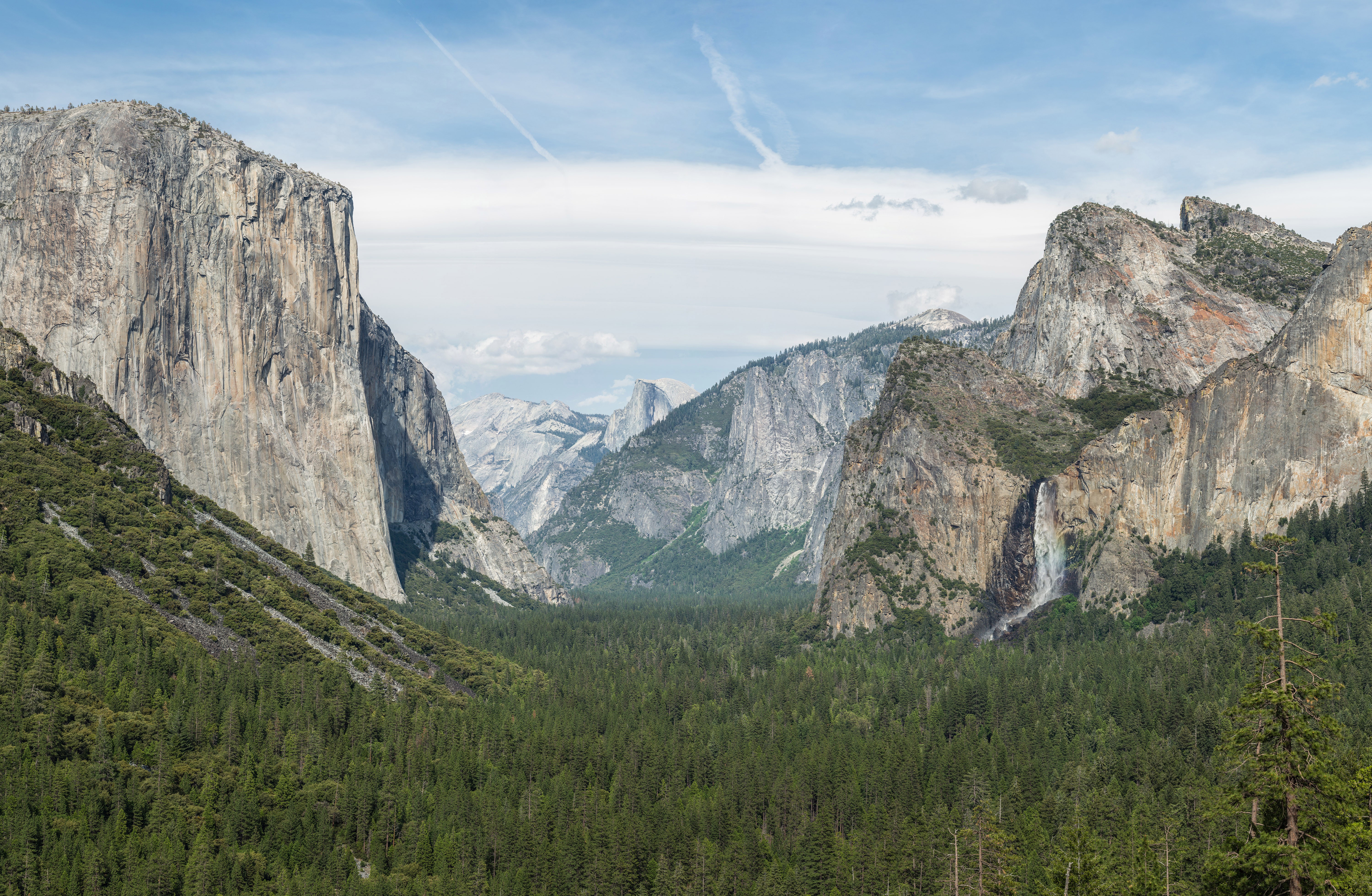
Tunnel View
   HOME
*


picture info

Tunnel View
Tunnel View is a scenic viewpoint on California State Route 41 in Yosemite National Park. Visitors have seen and documented the iconic and expansive views of Yosemite Valley from the overlook since its opening in 1933. The large viewpoint area is located directly east of the Wawona Tunnel portal, as one enters Yosemite Valley from points south. The view looks eastward into Yosemite Valley, and includes surrounding features, such as the southwest face of El Capitan on the left, Half Dome on axis, and Bridalveil Fall on the right. For many arriving by road, this is the stunning first view, upon suddenly exiting the long and dark tunnel, of Yosemite Valley and its setting. A turn out with parking lot accommodates leaving vehicles behind, to take it all in. The trailhead, for the hiking trail up and south to Inspiration Point, is located here. See also * National Register of Historic Places listings in Yosemite National Park This is a list of the National Register of Historic ...
[...More Info...]      
[...Related Items...]     OR:     [Wikipedia]   [Google]   [Baidu]  


picture info

El Capitan
El Capitan ( es, El Capitán; "the Captain" or "the Chief") is a vertical Rock formations in the United States, rock formation in Yosemite National Park, on the north side of Yosemite Valley, near its western end. The El Capitan Granite, granite monolith is about from base to summit along its tallest face and is a popular objective for rock climbers. Naming The formation was named "El Capitan" by the Mariposa Battalion when they explored the valley in 1851. ''El Capitán'' ("the captain", "the chief") was taken to be a loose Spanish translation of the local Native Americans in the United States, Native American name for the cliff, “Tutokanula” or "Rock Chief" (the exact spelling of Tutokanula varies in different accounts as it is a phonetic transcription of the Miwok, Miwok language). The "Rock Chief" etymology is based on the written account of Mariposa Battalion doctor Lafayette Bunnell in his 1892 book. Bunnell reports that Ahwahneechee Chief Tenaya explained to him, f ...
[...More Info...]      
[...Related Items...]     OR:     [Wikipedia]   [Google]   [Baidu]  


picture info

Tunnel View, Yosemite Valley, Yosemite NP - Diliff
A tunnel is an underground passageway, dug through surrounding soil, earth or rock, and enclosed except for the entrance and exit, commonly at each end. A pipeline is not a tunnel, though some recent tunnels have used immersed tube construction techniques rather than traditional tunnel boring methods. A tunnel may be for foot or vehicular road traffic, for rail transport, rail traffic, or for a canal. The central portions of a rapid transit network are usually in the tunnel. Some tunnels are used as sanitary sewer, sewers or aqueduct (watercourse), aqueducts to supply water for consumption or for hydroelectric stations. Utility tunnels are used for routing steam, chilled water, electrical power or telecommunication cables, as well as connecting buildings for convenient passage of people and equipment. Secret tunnels are built for military purposes, or by civilians for smuggling of weapons, contraband, or people. Special tunnels, such as wildlife crossings, are built to al ...
[...More Info...]      
[...Related Items...]     OR:     [Wikipedia]   [Google]   [Baidu]  


picture info

Scenic Viewpoint
A scenic viewpoint – also called an observation point, viewpoint, viewing point, vista point, lookout, scenic overlook,These terms are more commonly used in North America. etc. – is an elevated location where people can view scenery (often with binoculars) and photograph it. Scenic viewpoints may be created alongside scenic routes or mountain roads, often as simple turnouts or lay-bys where motorists can pull over onto pavement, gravel, or grass on the right-of-way. Many viewpoints are larger, having parking areas, while some (typically on larger highways) are off the road completely. Viewing points may also be found on hill or mountain tops or on rocky spurs overlooking a valley and reached via a hiking trail. They may be protected by railings to protect the public or be enhanced by a viewing tower designed to elevate visitors above the surrounding terrain or trees in order to offer panoramic views. Overlooks are frequently found in national parks, and in the U.S. along n ...
[...More Info...]      
[...Related Items...]     OR:     [Wikipedia]   [Google]   [Baidu]  


picture info

California State Route 41
State Route 41 (SR 41) is a state highway in California, connecting the Central Coast with the San Joaquin Valley and the Sierra Nevada. Its western terminus is at the Cabrillo Highway ( SR 1) in Morro Bay, and its eastern terminus is at SR 140 in Yosemite National Park. It has been constructed as an expressway from near SR 198 in Lemoore north to the south part of Fresno, where the Yosemite Freeway begins, passing along the east side of downtown and extending north into Madera County. Route description The majority of Route 41 runs as either two-lane rural highway or four-lane divided highway. The only part of SR 41 that turns into a freeway itself is in Fresno County and parts of Madera. The southern end of the highway intersects SR 1 in Morro Bay. Between Morro Bay and Fresno, the highway intersects U.S. Route 101 in Atascadero, proceeds through the Coast Range and intersects SR 46. Actor James Dean died in an accident in 1955 at the intersection of SR 46 in Cholame. ...
[...More Info...]      
[...Related Items...]     OR:     [Wikipedia]   [Google]   [Baidu]  


picture info

Yosemite National Park
Yosemite National Park ( ) is an American national park in California, surrounded on the southeast by Sierra National Forest and on the northwest by Stanislaus National Forest. The park is managed by the National Park Service and covers an area of and sits in four County, countiescentered in Tuolumne County, California, Tuolumne and Mariposa County, California, Mariposa, extending north and east to Mono County, California, Mono and south to Madera County, California, Madera County. Designated a World Heritage Site in 1984, Yosemite is internationally recognized for its granite cliffs, waterfalls, clear streams, Sequoiadendron giganteum, giant sequoia groves, lakes, mountains, meadows, glaciers, and Biodiversity, biological diversity. Almost 95 percent of the park is designated National Wilderness Preservation System, wilderness. Yosemite is one of the largest and least fragmented habitat blocks in the Sierra Nevada, and the park supports a diversity of plants and animals. The ...
[...More Info...]      
[...Related Items...]     OR:     [Wikipedia]   [Google]   [Baidu]  


picture info

Yosemite Valley
Yosemite Valley ( ; ''Yosemite'', Miwok for "killer") is a U-shaped valley, glacial valley in Yosemite National Park in the western Sierra Nevada (U.S.), Sierra Nevada mountains of Central California. The valley is about long and deep, surrounded by high granite summits such as Half Dome and El Capitan, and densely forested with pines. The valley is drained by the Merced River, and a multitude of streams and waterfalls flow into it, including Tenaya Creek, Tenaya, Illilouette, Yosemite Creek, Yosemite and Bridalveil Creeks. Yosemite Falls is the highest waterfall in North America and is a big attraction especially in the spring, when the water flow is at its peak. The valley is renowned for its natural environment and is regarded as the centerpiece of Yosemite National Park. The valley is the main attraction in the park for the majority of visitors and a bustling hub of activity during tourist season in the summer months. Most visitors enter the valley from roads to the west an ...
[...More Info...]      
[...Related Items...]     OR:     [Wikipedia]   [Google]   [Baidu]  


Wawona Tunnel
The Wawona Tunnel is a highway tunnel in Yosemite National Park. It, and Tunnel View just beyond its east portal, were completed in 1933. Wawona Tunnel is named after the community of Wawona but its name origin is not known. A popular story claims Wawō'na was the Miwok word for "big tree", or for "hoot of the owl", a bird considered the sequoia trees' spiritual guardian. Route Wawona Tunnel was bored through solid granite bedrock, and carries Wawona Road through a granite mountain on the south side of the Merced River. It is located on one of the three main roads providing access to Yosemite Valley, the most visited section of the park. Wawona Road becomes California State Route 41 on exiting the park. After passing through the tunnel, when leaving Yosemite Valley, Wawona Road continues to Chinquapin Junction with Glacier Point Road to Badger Pass ski area & Glacier Point, and reaches an elevation of above sea level. Specifications At long Wawona Tunnel is the longest highwa ...
[...More Info...]      
[...Related Items...]     OR:     [Wikipedia]   [Google]   [Baidu]  


picture info

Half Dome
Half Dome is a granite dome at the eastern end of Yosemite Valley in Yosemite National Park, California. It is a well-known rock formation in the park, named for its distinct shape. One side is a sheer face while the other three sides are smooth and round, making it appear like a dome cut in half. The granite crest rises more than above the valley floor. Geology The impression from the valley floor that this is a round dome that has lost its northwest half, is just an illusion. From Washburn Point, Half Dome can be seen as a thin ridge of rock, an arête, that is oriented northeast–southwest, with its southeast side almost as steep as its northwest side except for the very top. Although the trend of this ridge, as well as that of Tenaya Canyon, is probably controlled by master joints, 80 percent of the northwest "half" of the original dome may well still be there. Ascents As late as the 1870s, Half Dome was described as "perfectly inaccessible" by Josiah Whitney of the Ca ...
[...More Info...]      
[...Related Items...]     OR:     [Wikipedia]   [Google]   [Baidu]  


picture info

Bridalveil Fall
Bridalveil Fall is one of the most prominent waterfalls in the Yosemite Valley in California. The waterfall is in height and flows year round. Geology The glaciers that carved Yosemite Valley left many hanging valleys that spawned the waterfalls that pour into the valley. Most of the waterways that fed these falls carved the hanging valleys into steep cascades, however Bridalveil Creek still leaps into the valley from the edge of the precipice, although that edge has moved back into an alcove from the original edge of the valley. While Yosemite Falls seem to also fall into this category, the original course took the Yosemite Creek down a gorge to the west of its current location. The primary source of Bridalveil Fall is Ostrander Lake, some to the south. In a brisk wind, the falling water is often blown sideways, and when the flow is light, it may not reach the ground directly below. Because of this, the Ahwahneechee Native Americans called this waterfall "''Pohono''", whi ...
[...More Info...]      
[...Related Items...]     OR:     [Wikipedia]   [Google]   [Baidu]  


National Register Of Historic Places Listings In Yosemite National Park
This is a list of the National Register of Historic Places listings in Yosemite National Park. This is intended to be a complete list of the properties and districts on the National Register of Historic Places in Yosemite National Park, California, United States. The locations of National Register properties and districts for which the latitude and longitude coordinates are included below, may be seen in a Google map. There are 46 properties and districts listed on the National Register in the park and five National Historic Landmarks. Four more properties associated with the park are located just outside the park boundaries. Current listings Associated properties The following properties are on property owned by the National Park Service and administered by Yosemite National Park, but are not within the park proper: See also * National Register of Historic Places listings in Mariposa County, California * National R ...
[...More Info...]      
[...Related Items...]     OR:     [Wikipedia]   [Google]   [Baidu]  


:Category:Yosemite National Park
National parks in California Protected areas of the Sierra Nevada (United States) Parks in Mariposa County, California Parks in Tuolumne County, California Parks in Madera County, California World Heritage Sites in the United States Wikipedia categories named after parks in the United States {{CatAutoTOC ...
[...More Info...]      
[...Related Items...]     OR:     [Wikipedia]   [Google]   [Baidu]  


picture info

History Of Mariposa County, California
Mariposa County () is a county in the U.S. state of California. As of the 2020 U.S. Census, the population was 17,131. The county seat is Mariposa. It is located in the western foothills of the Sierra Nevada mountains, north of Fresno, east of Merced, and southeast of Stockton. The county's eastern section is the central portion of Yosemite National Park. There are no incorporated cities in Mariposa County; however, there are communities recognized as census-designated places for statistical purposes. It also has the distinction of having no actual traffic signals anywhere in the county. History Mariposa County was one of the original counties of California, created at the time of statehood in 1850. While it began as the state's largest county, territory that was once part of Mariposa was ceded over time to form all or part of twelve other counties, including all of Merced, Madera, Fresno, Tulare, Kings, and Kern; and parts of San Benito, Mono, Inyo, San Bernardino, and L ...
[...More Info...]      
[...Related Items...]     OR:     [Wikipedia]   [Google]   [Baidu]