|
Tsipa River
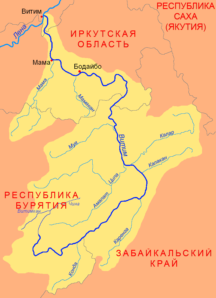
The Tsipa (russian: Ципа) is the largest tributary of the Vitim in Buryatia, Russia. It is long, and has a drainage basin of . Maksim Perfilyev was the first Russian to reach the Tsipa in 1640. Perch, pike, lenok, grayling, taimen and whitefish are also found in the waters of the Tsipa. Course The Tsipa is a western, left tributary of the Vitim. It has its sources in a tarn of the Southern Muya Range, in the area where this range merges with the Ikat Range. It is known as "Upper Tsipa" (Верхняя Ципа) in its upper course until its mouth in lake Baunt in the Baunt Depression in the northeastern part of the Vitim Plateau, near the Bolshoy Khapton Range. The river flows out of the lake in a NNE direction and slows down meandering across a swampy basin where there are many lakes, the largest of which is Busani. Then it turns south and crosses the Babanty Range through a narrow valley where it flows fast, forming rapids Rapids are sections of a river ... [...More Info...] [...Related Items...] OR: [Wikipedia] [Google] [Baidu] |
Southern Muya Range
The Southern Muya Range (russian: Южно-Муйский хребе́т, translit=Yuzhno-Muyskiy khrebet) is a mountain range in Buryatia and Zabaykalsky Krai Zabaykalsky Krai ( rus, Забайкальский край, r=Zabaikal'skii krai, p=zəbɐjˈkalʲskʲɪj kraj, lit. "Transbaikal krai"; bua, Yбэр Байгалай хизаар, Uber Baigalai Xizaar) is a federal subject of Russia (a krai) t ..., Russia, part of the Stanovoy Highlands. The highest point of the range is 3,067 m high Muisky Gigant; another important peak is 2363 m high Mount Shaman. Google Earth Geography This mountain range is located in the Baikal Rift Zone, in the southwestern part of the Baikal-Stanovoy Region. It stretches from west to east for almost 400 km from the Barguzin (river), Barguzin river basin to the upper course of the Chara (river), Chara River. In its eastern part it reaches a maximum width of 80 km. The Ikat Range connects with it from the southwest. The Southern Muya Range is limite ... [...More Info...] [...Related Items...] OR: [Wikipedia] [Google] [Baidu] |
Baunt
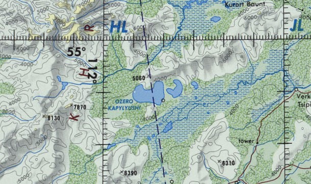
Baunt (russian: Баунт; bxr, Баунт нуур, ''Baunt nuur'') is the name of a body of fresh water in the Bauntovsky District, Buryatia, Russia. The village of Kurort Baunt, where there are some hot springs, is located on the southwestern shore of the lake, at the foot of Mt Bolshoy Khapton, near the confluence of the Upper Tsipa, and the village of Baunt is on the northeastern shore. At a headland named Cape Tryokhstanka there are ancient petroglyphs. The lake is a protected area since 1988. Its environment provides a habitat for a number of fish and bird species, as well as the crustacean ''Asellus aquaticus''. Geography The lake has a roughly triangular shape. It stretches in a southwest-northeast direction parallel to the main ridge of the Southern Muya Range to the north and the Baunt Basin, with the Maly Khapton and Babanty Range, two ranges of the Vitim Plateau, to the south. The Ikat Range rises to the west and the Kapylyushi lakes lie to the southwest. The Upper ... [...More Info...] [...Related Items...] OR: [Wikipedia] [Google] [Baidu] |
Vitim ;
{{Set index article, populated places in Russia ...
Vitim (russian: Витим) is the name of several inhabited localities in Russia. Modern localities *Vitim, Sakha Republic, an urban locality (an urban-type settlement) in Lensky District of the Sakha Republic *Vitim, Republic of Buryatia, a rural locality (a settlement) in Muysky Selsoviet of Muysky District in the Republic of Buryatia; Alternative names *Vitim, alternative name of Romanovka, a '' selo'' in Vitimsky Selsoviet of Bauntovsky District in the Republic of Buryatia Buryatia, officially the Republic of Buryatia (russian: Республика Бурятия, r=Respublika Buryatiya, p=rʲɪsˈpublʲɪkə bʊˈrʲætʲɪjə; bua, Буряад Улас, Buryaad Ulas, , mn, Буриад Улс, Buriad Uls), is ... [...More Info...] [...Related Items...] OR: [Wikipedia] [Google] [Baidu] |
Great Soviet Encyclopedia
The ''Great Soviet Encyclopedia'' (GSE; ) is one of the largest Russian-language encyclopedias, published in the Soviet Union from 1926 to 1990. After 2002, the encyclopedia's data was partially included into the later ''Bolshaya rossiyskaya entsiklopediya'' (or '' Great Russian Encyclopedia'') in an updated and revised form. The GSE claimed to be "the first Marxist–Leninist general-purpose encyclopedia". Origins The idea of the ''Great Soviet Encyclopedia'' emerged in 1923 on the initiative of Otto Schmidt, a member of the Russian Academy of Sciences. In early 1924 Schmidt worked with a group which included Mikhail Pokrovsky, (rector of the Institute of Red Professors), Nikolai Meshcheryakov (Former head of the Glavit, the State Administration of Publishing Affairs), Valery Bryusov (poet), Veniamin Kagan (mathematician) and Konstantin Kuzminsky to draw up a proposal which was agreed to in April 1924. Also involved was Anatoly Lunacharsky, People's Commissar of Education ... [...More Info...] [...Related Items...] OR: [Wikipedia] [Google] [Baidu] |
Amalat
The Amalat (russian: Амалат) is a river in Buryatia, Russia. It is the largest tributary of the Tsipa, of the Vitim basin.Ципа / '':'' in 30 vols. / Ch. ed. A.M. Prokhorov. - 3rd ed. - M. Soviet Encyclopedia, 1969-1978. The river is long, and has a drainage basin of . The villages of Baysa, and |
Tsipikan (river)
The Tsipikan (russian: Ципикан) is a river in Buryatia, Russia. It is the second largest tributary of the Tsipa, after the Amalat, of the Vitim basin. The river is long, and has a drainage basin of . There is gold mining in the banks of the river. Course The Tsipikan is a tributary of the Tsipa. It has its sources in the eastern slopes of the Ikat Range. First it flows northeastwards as it progresses across the mountains of the northwestern corner of the Vitim Plateau. Its course slows down and becomes marshy in the Kapylyushi lake area, south of the slopes of the Bolshoy Khapton. After a sharp turn to the southeast, and then northeast, it ends up flowing northwards meandering strongly and finally entering the eastern shore of lake Baunt. Tsipikan village is located on the right bank of the river. There are many swampy stretches in the Tsipikan basin, as well as 863 lakes with a total area of . The main tributaries of the Tsipikan are the long Taloy from the right, an ... [...More Info...] [...Related Items...] OR: [Wikipedia] [Google] [Baidu] |
Taksimo
Taksimo (russian: Таксимо́; Buryat and mn, Таксимо, ''Taksimo'') is an urban locality (an urban-type settlement) and the administrative center of Muysky District of the Republic of Buryatia, Russia, located on the Muya River on the Muysk Plateau in the far northeast of the republic. As of the 2010 Census, its population was 9,438. Etymology Taksimo's name comes from the Evenki language and means ''cup'' or ''bowl'', possibly because of its location in a valley in Muysky Mountains. History Buryats, who had emigrated from the Chara River area, began settling the region in the 1860s, although a number of Evenks already lived there. Modern Taksimo began as the settlement of exile Ivan Barancheyev, who escaped from the settlement of Kirensk in the Lena mining area during rioting in 1905. He gradually wandered along the Vitim River and eventually settled in the area of present-day Taksimo in 1910. Barancheyev's outpost became a trading point for stagecoaches, alt ... [...More Info...] [...Related Items...] OR: [Wikipedia] [Google] [Baidu] |
Rapids
Rapids are sections of a river where the river bed has a relatively steep gradient, causing an increase in water velocity and turbulence. Rapids are hydrological features between a ''run'' (a smoothly flowing part of a stream) and a ''cascade''. Rapids are characterized by the river becoming shallower with some rocks exposed above the flow surface. As flowing water splashes over and around the rocks, air bubbles become mixed in with it and portions of the surface acquire a white color, forming what is called "whitewater". Rapids occur where the bed material is highly resistant to the erosive power of the stream in comparison with the bed downstream of the rapids. Very young streams flowing across solid rock may be rapids for much of their length. Rapids cause water aeration of the stream or river, resulting in better water quality. Rapids are categorized in classes, generally running from I to VI. A Class 5 rapid may be categorized as Class 5.1-5.9. While Class I rapids are eas ... [...More Info...] [...Related Items...] OR: [Wikipedia] [Google] [Baidu] |
Busani
Busani (russian: Бусани) is the name of a body of fresh water in the Bauntovsky District, Buryatia, Russia. The name originated in the Evenki language, meaning "where people drown". There are spectacular rock formations on the southeastern shore of lake Busani. It was declared a protected area of Russia on 25 July 1988. Geography Busani is one of the major lakes of the Baunt Depression, below the southern foothills of the Southern Muya Range.Busani / '':'' in 30 vols. / Ch. ed. . - 3rd ed. - M. Soviet Encyclopedia, 1969-1978. ... [...More Info...] [...Related Items...] OR: [Wikipedia] [Google] [Baidu] |
Meandering
A meander is one of a series of regular sinuous curves in the channel of a river or other watercourse. It is produced as a watercourse erodes the sediments of an outer, concave bank (cut bank) and deposits sediments on an inner, convex bank which is typically a point bar. The result of this coupled erosion and sedimentation is the formation of a sinuous course as the channel migrates back and forth across the axis of a floodplain. The zone within which a meandering stream periodically shifts its channel is known as a meander belt. It typically ranges from 15 to 18 times the width of the channel. Over time, meanders migrate downstream, sometimes in such a short time as to create civil engineering challenges for local municipalities attempting to maintain stable roads and bridges.Neuendorf, K.K.E., J.P. Mehl Jr., and J.A. Jackson, J.A., eds. (2005) ''Glossary of Geology'' (5th ed.). Alexandria, Virginia, American Geological Institute. 779 pp. Charlton, R., 2007. ''Fundamentals o ... [...More Info...] [...Related Items...] OR: [Wikipedia] [Google] [Baidu] |
Bolshoy Khapton
The Bolshoy Khapton (russian: Большой Хаптон) is a mountain range in Bauntovsky District, Buryatia, Russia. The nearest airport is Bagdarin Airport.Google Earth Geography This mountain range is located in the northeastern part of the Vitim Plateau. It stretches from southwest to northeast for almost 50 km between the Kapylyushi lake group and the southern shores of Baunt lake. The Bolshoy Khapton range is part of the watershed of the Tsipikan and Upper Tsipa rivers. In its eastern section it reaches a maximum width of 10 km. The highest point of the range is high Mt Bolshoy Khapton. to the south, across the Tsipikan River, rises the smaller Maly Khapton range, highest point . It runs parallel to the Bolshoy Khapton at the southern limit of the Baunt Depression. See also *List of mountains and hills of Russia This is a list of mountains and hills of Russia. List by elevation Over 5000 meters 4000 to 4999 meters 3000 to 3999 meters 2000 to 2999 meter ... [...More Info...] [...Related Items...] OR: [Wikipedia] [Google] [Baidu] |


