|
Trongsa
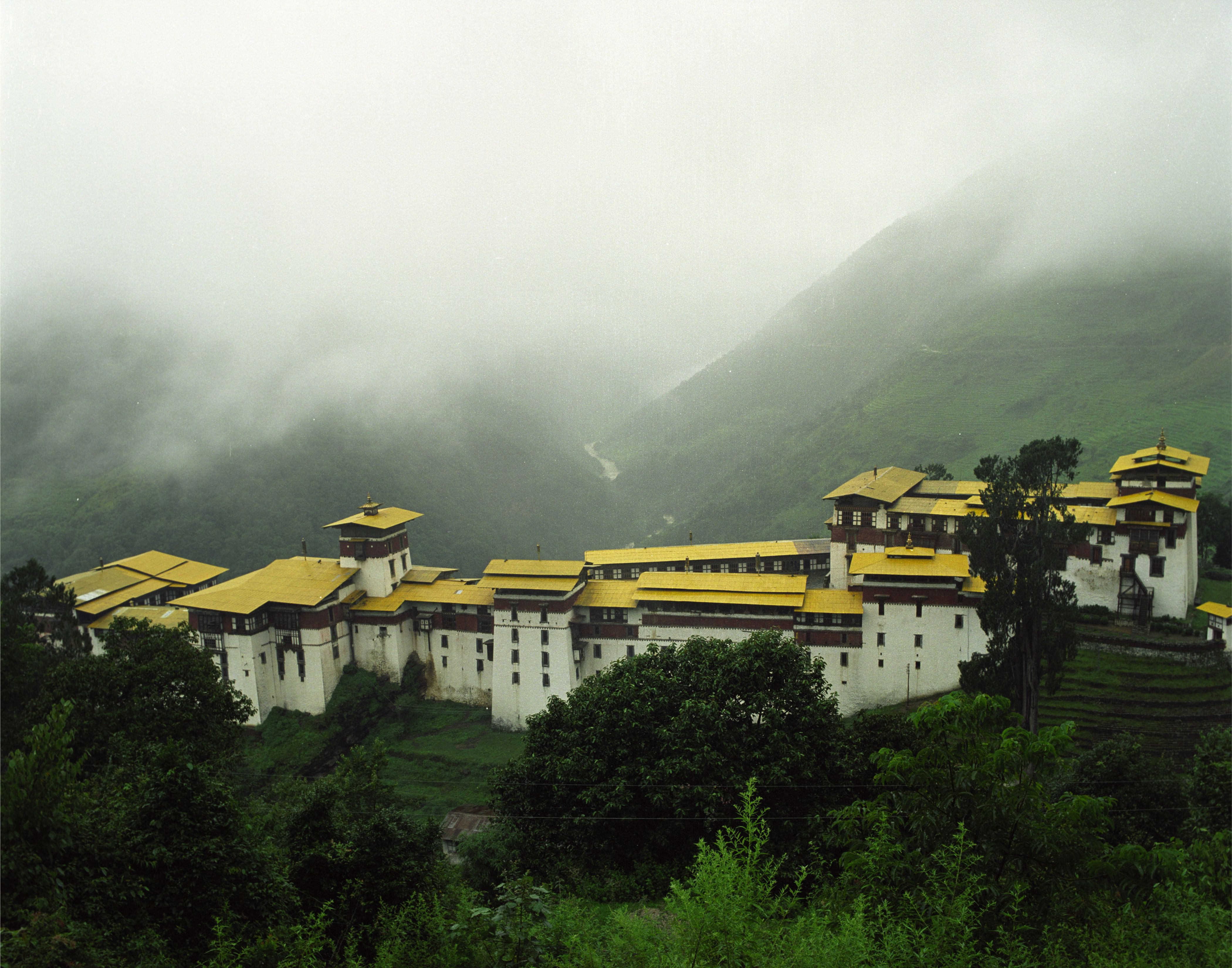
Trongsa, previously Tongsa (, ), is a Thromde or town, and the capital of Trongsa District in central Bhutan. The name means "new village" in Dzongkha. The first temple was built in 1543 by the Drukpa lama Ngagi Wangchuck, who was the great-grandfather of Ngawang Namgyal, Zhabdrung Rinpoche, the unifier of Bhutan. Trongsa Dzong Chökhor Raptentse Dzong at Trongsa which was built in 1644, used to be the seat of power of the Wangchuck dynasty before it became rulers of Bhutan in 1907. Traditionally the King of Bhutan first becomes the Trongsa Penlop (governor) before being named Crown Prince and eventually King. Built on a mountain spur high above the gorges of the Mangde Chhu, the dzong controlled east-west trade for centuries. The only road connecting eastern and western Bhutan (the precursor to the modern Lateral Road), passed through the courtyard of the dzong. At the command of the ''penlop'' the massive doors could be shut, dividing the country in two. Higher yet on the ... [...More Info...] [...Related Items...] OR: [Wikipedia] [Google] [Baidu] |
Trongsa Dzong
Trongsa Dzong is the largest dzong fortress in Bhutan, located in Trongsa (formerly Tongsa) in Trongsa district, in the centre of the country. Built on a spur overlooking the gorge of the Mangde River, a temple was first established at the location in 1543 by the Drukpa lama, Nagi Wangchuk son of Ngawang Chhojey. In 1647, his great-grandson ''Shabdrung'' Ngawang Namgyal (Shabdrung or Zhabdrung being his title),Dorje (1999), p. 856. constructed the first dzong to replace it, called Chökhor Rabtentse Dzong with a shorter version of Choetse Dzong. It was enlarged several times during the 18th century; the Chenrezig Lhakang was built in 1715 and a whole complex, including the Maitreya (Jampa) temple, was added in 1771. The dzong has since been repaired on several occasions; it was damaged during the 1897 Assam earthquake and underwent extensive renovation in 1927 and 1999.Pommaret (2006), p.211. Trongsa Dzong, the largest dzong at a striking location, is an important administrative ... [...More Info...] [...Related Items...] OR: [Wikipedia] [Google] [Baidu] |
Penlop
Penlop ( Dzongkha: དཔོན་སློབ་; Wylie: ''dpon-slob''; also spelled Ponlop, Pönlop) is a Dzongkha term roughly translated as governor. Bhutanese penlops, prior to unification, controlled certain districts of the country, but now hold no administrative office. Rather, penlops are now entirely subservient to the House of Wangchuck. Traditionally, Bhutan comprised nine provinces: Trongsa, Paro, Punakha, Wangdue Phodrang, Daga (also Taka, Tarka, or Taga), Bumthang, Thimphu, Kurtoed (also Kurtoi, Kuru-tod), and Kurmaed (or Kurme, Kuru-mad). The Provinces of Kurtoed and Kurmaed were combined into one local administration, leaving the traditional number of governors at eight. While some lords were penlops, others held the title Dzongpen ( Dzongkha: རྗོང་དཔོན་; Wylie: ''rjong-dpon''; also "Jongpen," "Dzongpön"), a title also translated as "governor." Other historical titles, such as "Governor of Haa," were also awarded. Under the dual syste ... [...More Info...] [...Related Items...] OR: [Wikipedia] [Google] [Baidu] |
Penlop Of Trongsa
Penlop of Trongsa ( Dzongkha: ཀྲོང་གསར་དཔོན་སློབ་; Wylie: ''Krong-gsar dpon-slob''), also called Chhoetse Penlop ( Dzongkha: ཆོས་རྩེ་དཔོན་སློབ་; Wylie: ''Chos-rtse dpon-slob''; also spelled "Chötse"),The spelling of this title varies widely in sources because transliterations of Tibetan script and transcriptions of Tibetan phonology differ. ''Penlop'' may be spelled "pönlop" or "ponlop". ''Trongsa'' may appear as "Tongsa" or even "(b)Krongsa". ''Chotse'' may alternatively appear as "Chhotse", "Ch(h)oetse" or "Ch(h)ötse". Any combination of these variations may also contain additional hyphens or differing capitalization. is a Dzongkha title meaning "Governor of the Province of Trongsa (Chhoetse)". It is generally given to the heir apparent of the Kingdom of Bhutan. The most recent holder of the title was King Jigme Khesar Namgyel Wangchuck, who was then a prince (Dzongkha: ''dasho'', ''gyalsey''). The cu ... [...More Info...] [...Related Items...] OR: [Wikipedia] [Google] [Baidu] |
House Of Wangchuck
The Wangchuck dynasty () have held the hereditary position of Druk Gyalpo ("Dragon King") of Bhutan since 1907. Prior to reunification, the Wangchuck family had governed the district of Trongsa as descendants of Dungkar Choji. They eventually overpowered other regional lords and earned the favour of the British Empire. After consolidating power, the 12th Penlop of Trongsa ''Gongsar'' Ugyen Wangchuck was elected Druk Gyalpo, thus founding the dynasty. The position of Druk Gyalpo – who heads the royal family of Bhutan – is more commonly known in English as the King of Bhutan, however "Druk Gyalpo" would be translated literally as "Dragon King" (or less commonly, "King of the Dragons," or "Thunder Dragon King") The Wangchuck dynasty ruled government power in Bhutan and established relations with the British Empire and India under its first two monarchs. The third, fourth, and fifth (current) monarchs have put the kingdom on its path toward democratization, decentralization, and ... [...More Info...] [...Related Items...] OR: [Wikipedia] [Google] [Baidu] |
Trongsa Province
Trongsa Province ( Dzongkha: ཀྲོང་གསར་; Wylie: ''krong-gsar'') was one of the nine historical Provinces of Bhutan. Trongsa Province occupied lands in central Bhutan corresponding somewhat to modern Trongsa District, although the power of the Trongsa Penlop extended far beyond his own realms, covering the entire east of Bhutan. The province was administered from the Trongsa Dzong in the town of Trongsa, and its ruling governor was known as the Penlop of Trongsa, or Tongsab. History Under Bhutan's early theocratic dual system of government, decreasingly effective central government control resulted in the ''de facto'' disintegration of the office of Shabdrung after the death of ''Shabdrung'' Ngawang Namgyal in 1651. Under this system, the Shabdrung reigned over the temporal Druk Desi and religious Je Khenpo. Two successor Shabdrungs – the son (1651) and stepbrother (1680) of Ngawang Namgyal – were effectively controlled by the Druk Desi and Je Khenpo until p ... [...More Info...] [...Related Items...] OR: [Wikipedia] [Google] [Baidu] |
Trongsa District
Trongsa District (Dzongkha: ཀྲོང་གསར་རྫོང་ཁག་; Wylie transliteration: ''Krong-gsar rdzong-khag'') is one of the districts of Bhutan. It is the most central district of Bhutan and the geographic centre of Bhutan is located within it at Trongsa Dzong. Languages Trongsa is a linguistically diverse district. In the north and east inhabitants speak Bumthangkha, and in the extreme southeast Khengkha is spoken. Nyenkha is spoken in the western half of the district, straddling the border with Wangdue Phodrang District. To the north, along and across the same border, live speakers of Lakha. In the extreme south, the national language Dzongkha is spoken. Across the mid-south, tiny communities of autochthonous 'Olekha (Black Mountain Monpa) speakers have all but disappeared. Historically, Bumthangkha and its speakers have had close contact with speakers of Kurtöpkha, Mangduepikha and Khengkha, nearby languages of central and eastern Bhutan, to the exten ... [...More Info...] [...Related Items...] OR: [Wikipedia] [Google] [Baidu] |
Bhutan
Bhutan (; dz, འབྲུག་ཡུལ་, Druk Yul ), officially the Kingdom of Bhutan,), is a landlocked country in South Asia. It is situated in the Eastern Himalayas, between China in the north and India in the south. A mountainous country, Bhutan is known as "Druk Yul," or "Land of the Thunder Dragon". Nepal and Bangladesh are located near Bhutan but do not share a land border. The country has a population of over 727,145 and territory of and ranks 133rd in terms of land area and 160th in population. Bhutan is a Constitutional Democratic Monarchy with King as head of state and Prime Minister as head of government. Mahayana and Vajrayana Buddhism is the state religion and the Je Khenpo is the head of state religion. The subalpine Himalayan mountains in the north rise from the country's lush subtropical plains in the south. In the Bhutanese Himalayas, there are peaks higher than above sea level. Gangkhar Puensum is Bhutan's highest peak and is the highest uncl ... [...More Info...] [...Related Items...] OR: [Wikipedia] [Google] [Baidu] |
Districts Of Bhutan
The Kingdom of Bhutan is divided into 20 districts ( Dzongkha: ). Bhutan is located between the Tibet Autonomous Region of China and India on the eastern slopes of the Himalayas in South Asia. are the primary subdivisions of Bhutan. They possess a number of powers and rights under the Constitution of Bhutan, such as regulating commerce, running elections, and creating local governments. The Local Government Act of 2009 established local governments in each of the 20 overseen by the Ministry of Home and Cultural Affairs. Each has its own elected government with non-legislative executive powers, called a (district council). The is assisted by the administration headed by a (royal appointees who are the chief executive officer of each ). Each also has a court presided over by a (judge), who is appointed by the Chief Justice of Bhutan on the advice of Royal Judicial Service Council. The , and their residents, are represented in the Parliament of Bhutan, a bicameral l ... [...More Info...] [...Related Items...] OR: [Wikipedia] [Google] [Baidu] |
Thromde
A thromde ( Dzongkha: ཁྲོམ་སྡེ་; Wylie: ''khrom-sde'') is a second-level administrative division in Bhutan. The legal administrative status of thromdes was most recently codified under the Local Government Act of 2009, and the role of thromdes in elections in Bhutan was defined in the Election Act of 2008 Governance Thromde administration is a product of the Bhutanese program of decentralization and devolution of power and authority. Thromdes are administered independently by a Thromde Tshogde if sufficiently developed and populated (Class A Thromdes); or directly by Dzongkhag Administration or the Gewog Administration as decided by the Government (Class B Thromdes and Yenlag Thromdes). From time to time, Parliament decides the boundaries of Thromde in consultation with the National Land Commission Secretariat and local authorities. Each Thromde Tshogde is composed of seven to ten elected members and headed by a Thrompon. Thromde Tshogdes are empowered to reg ... [...More Info...] [...Related Items...] OR: [Wikipedia] [Google] [Baidu] |
Dzong
Dzong architecture is used for dzongs, a distinctive type of fortified monastery ( dz, རྫོང, , ) architecture found mainly in Bhutan and Tibet. The architecture is massive in style with towering exterior walls surrounding a complex of courtyards, temples, administrative offices, and monks' accommodation. Characteristics Distinctive features include: * High inward sloping walls of brick and stone painted white with few or no windows in the lower sections of the wall * Use of a surrounding red ochre stripe near the top of the walls, sometimes punctuated by large gold circles * Use of unique style flared roofs atop interior temples * Massive entry doors made of wood and iron * Interior courtyards and temples brightly colored in Buddhist-themed art motifs such as the ashtamangala or swastika Regional differences Bhutan Dzongs serve as the religious, military, administrative, and social centers of their district. They are often the site of an annual ''tsechu'' or religious ... [...More Info...] [...Related Items...] OR: [Wikipedia] [Google] [Baidu] |
Mangde Chhu
Mangde Chhu or Tongsa river flows in central Bhutan traversing roughly north–south. The river rises in Wangdue Phodrang district (or dzongkhag in Dzongkha), near Gangkhar Puensum, Bhutan's highest peak at . Bhutan's main east–west highway crosses the Mangde Chhu about west of Trongsa. South of Trongsa, the river drains the eastern slopes of the Black Mountains (Bhutan), and forms the eastern boundaries of Black Mountain National Park and Royal Manas National Park. Another highway follows the river south from Trongsa to Shemgang. The highway leaves the river at Tingtinbi, and eventually reaches the Indian border at Gelegphug. South of Tingtinbi, the Mangde is joined by the Bumthang River from the east, and is known as the Tongasa. Shortly before entering India in Assam, the Manas River flows into the river from the east, and the river exits Bhutan near Manas. Important towns and areas through which the Trongsa - Gelegphug road passes are Shemgang (Shamgong), Taama, Ba ... [...More Info...] [...Related Items...] OR: [Wikipedia] [Google] [Baidu] |
Lateral Road
The East-West Highway, also known as the Lateral Road, is the Bhutan primary east–west corridor, connecting Phuentsholing in the southwest to Trashigang in the east. In between, the Lateral Road runs directly through Wangdue Phodrang, Trongsa, and other population centers. The Lateral Road also has spurs connecting to the capital Thimphu and other major population centers such as Paro and Punakha. The Lateral Road traverses are a number of high passes, including Tremo La and Dochu La. The highest pass on the road is at Chele La; the second-highest pass is at Trumshing La in central Bhutan at an altitude of over . The Lateral Road and society The works that formed the Lateral Road, among other development projects, were fruits of mostly Indian and Nepali laborers. Their contributions were necessary to bolster Bhutanese national security and to connect populations. As the Lateral Road has led to increased infrastructure development, it has added to a sense of national unity, ... [...More Info...] [...Related Items...] OR: [Wikipedia] [Google] [Baidu] |
.jpg)


