|
Triboldingerbohl
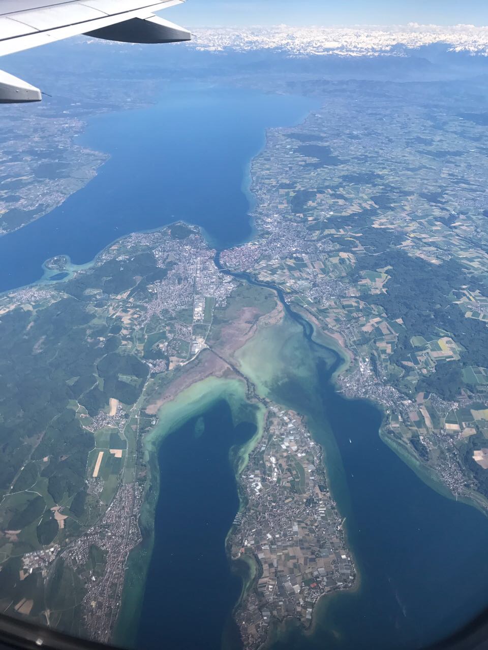
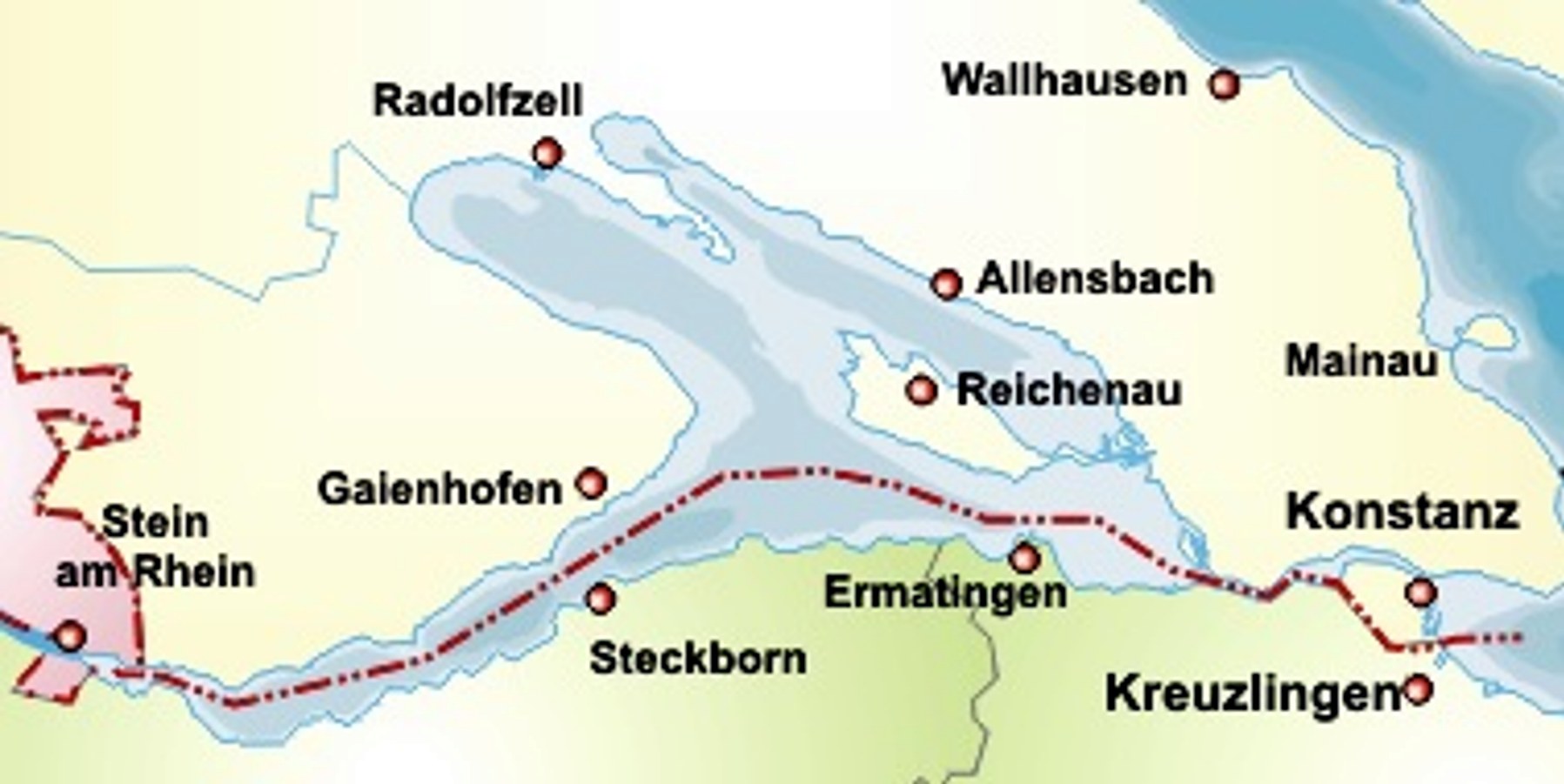
Triboldingerbohl, also known as Triboltingen or großes Bohl or Langenrain, is the fourth largest island of Lake Constance, with an area of . It is long and up to wide. It is located in the easternmost part of the Untersee (Lake Constance), near the point where the Seerhein flows into the lake. This part of the lake is also known as the Rheinsee. It belongs to the Wollmatinger Ried nature conservation area; administratively it belongs to the district ''industrial area'' of the City of Constance. Until 1934, it belonged to the municipality of Wollmatingen, which was then annexed by Constance. Triboldingerbohl lies southeast of Reichenau Island and from the dam that connects Reichenau to the mainland. The area between Triboldingerbohl island and the Reichenau dam is called ''Ermatinger pool'' and is an ecologically important shallow-water zone. Triboldingerbohl is uninhabited. It is a bird sanctuary. It takes its name from the former Swiss municipality Triboltinge ... [...More Info...] [...Related Items...] OR: [Wikipedia] [Google] [Baidu] |
Lake Constance
Lake Constance (german: Bodensee, ) refers to three Body of water, bodies of water on the Rhine at the northern foot of the Alps: Upper Lake Constance (''Obersee''), Lower Lake Constance (''Untersee''), and a connecting stretch of the Rhine, called the Seerhein, Lake Rhine (''Seerhein''). These waterbodies lie within the Lake Constance Basin () in the Alpine Foreland through which the Rhine flows. The lake is situated where Germany, Switzerland, and Austria meet. Its shorelines lie in the German states of Baden-Württemberg and Bavaria, the Swiss cantons of Canton of St. Gallen, St. Gallen, Canton of Thurgau, Thurgau, and Canton of Schaffhausen, Schaffhausen, and the Austrian state of Vorarlberg. The actual location of the border Lake_Constance#International_borders, is disputed. The Alpine Rhine forms in its original course the Austro-Swiss border and flows into the lake from the south. The High Rhine flows westbound out of the lake and forms (with the exception of the Canton ... [...More Info...] [...Related Items...] OR: [Wikipedia] [Google] [Baidu] |
Wollmatinger Ried
The nature reserve of Wollmatinger Ried – Untersee – Gnadensee is a protected area on the shores of Lake Constance in Germany. It has an area of 767 hectares and is the largest and most important nature reserve on the German side of Lake Constance. It is rich in plant and animal species and extends from the banks of the Seerhein river west of Constance via the causeway to the Island of Reichenau in the Untersee to the eastern Gnadensee near Allensbach-Hegne. The nearby offshore islands of Triboldingerbohl (Langenrain) and Mittler or Langbohl (Kopf) are part of the reserve. Literature * Sources nabu-wollmatingerried.de: Das Wollmatinger Ried* Regierungspräsidium Freiburg Freiburg im Breisgau (; abbreviated as Freiburg i. Br. or Freiburg i. B.; Low Alemannic: ''Friburg im Brisgau''), commonly referred to as Freiburg, is an independent city in Baden-Württemberg, Germany. With a population of about 230,000 (as o ...: Faltblatt zum Naturschutzgebiet Wollmatinger Ried ... [...More Info...] [...Related Items...] OR: [Wikipedia] [Google] [Baidu] |
Seerhein
The Seerhein ("Lake Rhine") is a river about four kilometres long, in the basin of Lake Constance. It is the outflow of the Upper Lake Constance and the main tributary of the Lower Lake Constance. The water level of the lower lake is about 30 cm below the level of the Upper Lake. It is considered part of the Rhine, which flows into Lake Constance as the Alpine Rhine and flows out of the Lake as the High Rhine. The Seerhein arose after the last ice age (the Würm glaciation, about 9650 BCE). Some time after this period, the water level of Lake Constance gradually dropped by about ten metres and the shallow parts fell dry. Some parts of the Seerhein still have a character a bit like a lake. The border between Germany and Switzerland runs down the center of the lower stretch of the river; the German city of Constance, the largest community on the river, is situated on both sides of the upper part. Location General The Seerhein extends over a length of 4.3 km f ... [...More Info...] [...Related Items...] OR: [Wikipedia] [Google] [Baidu] |
Reichenau Island
Reichenau Island () is an island in Lake Constance in Southern Germany. It lies almost due west of the city of Konstanz, between the Gnadensee and the Untersee, two parts of Lake Constance. With a total land surface of and a circumference of , the island is long and wide at its greatest extent. The highest point, the Hochwart, stands some above the lake surface and above mean sea level. Reichenau is connected to the mainland by a causeway, completed in 1838, which is intersected between the ruins of Schopflen Castle and the eastern end of Reichenau Island by a -wide and long waterway, the Bruckgraben. A low road bridge allows the passage of ordinary boats but not of sailing-boats. In 724, the first monastery was built on the island by the bishop Pirmin, and Reichenau quickly developed into an influential religious, cultural, and intellectual center. During the Early and High Middle Ages, the Reichenau Abbey was one of the significant monasteries across the Frankish Emp ... [...More Info...] [...Related Items...] OR: [Wikipedia] [Google] [Baidu] |
Uninhabited Islands Of Germany
The list of uninhabited regions includes a number of places around the globe. The list changes year over year as human beings migrate into formerly uninhabited regions, or migrate out of formerly inhabited regions. List As a group, the list of uninhabited places are called the "nonecumene". This is a special geography term which means the uninhabited area of the world. * Virtually all of the Ocean *Virtually all of Antarctica *Most of The Arctic *Most of Greenland *Most of The Sahara * Antipodes Islands * Ashmore and Cartier Islands * Bajo Nuevo Bank * Baker Island * Ball's Pyramid * Balleny Islands * Big Major Cay * Bouvet Island * Much of the interior of Brazil * Caroline Island * Clipperton Island * The semi-arid regions and deserts of Australia * Devon Island * Much of Eastern Oregon * Elephant Island * Elobey Chico * Ernst Thälmann Island * Much of Fiordland, New Zealand * Goa Island * Gough Island * Hans Island * Harmil * Hashima Island * Hatutu * Heard Island ... [...More Info...] [...Related Items...] OR: [Wikipedia] [Google] [Baidu] |
Blue-green Algae
Cyanobacteria (), also known as Cyanophyta, are a phylum of gram-negative bacteria that obtain energy via photosynthesis. The name ''cyanobacteria'' refers to their color (), which similarly forms the basis of cyanobacteria's common name, blue-green algae, although they are not usually scientifically classified as algae. They appear to have originated in a freshwater or terrestrial environment. Sericytochromatia, the proposed name of the paraphyletic and most basal group, is the ancestor of both the non-photosynthetic group Melainabacteria and the photosynthetic cyanobacteria, also called Oxyphotobacteria. Cyanobacteria use photosynthetic pigments, such as carotenoids, phycobilins, and various forms of chlorophyll, which absorb energy from light. Unlike heterotrophic prokaryotes, cyanobacteria have internal membranes. These are flattened sacs called thylakoids where photosynthesis is performed. Phototrophic eukaryotes such as green plants perform photosynthesis in plast ... [...More Info...] [...Related Items...] OR: [Wikipedia] [Google] [Baidu] |
Reed (plant)
Reed is a common name for several tall, grass-like plants of wetlands. Varieties They are all members of the order Poales (in the modern, expanded circumscription), and include: In the grass family, Poaceae * Common reed (''Phragmites australis''), the original species named reed * Giant reed (''Arundo donax''), used for making reeds for musical instruments * Burma reed (''Neyraudia reynaudiana'') * Reed canary-grass (''Phalaris arundinacea'') * Reed sweet-grass (''Glyceria maxima'') * Small-reed (''Calamagrostis'' species) In the sedge family, Cyperaceae * Paper reed or papyrus ('' Cyperus papyrus''), the source of the Ancient Egyptian writing material, also used for making boats In the family Typhaceae * Bur-reed (''Sparganium'' species) * Reed-mace (''Typha'' species), also called bulrush or cattail In the family Restionaceae * Cape thatching reed ('' Elegia tectorum''), a restio originating from the South-western Cape, South Africa. * Thatching reed (''Thamnochortus ins ... [...More Info...] [...Related Items...] OR: [Wikipedia] [Google] [Baidu] |
Triboltingen
Triboltingen is a small village in the canton of Thurgau in Switzerland, situated on the south shore of the ''Untersee'' part of Lake Constance. Since 1975, it is politically part of Ermatingen Ermatingen is a municipality in the district of Kreuzlingen in the canton of Thurgau in Switzerland. History The Stone Age Westerfeld and Büge shoreline settlements were discovered in 1861 and studied extensively 1981-83, with finds from the .... Geography of Thurgau Villages in Switzerland Former municipalities of Thurgau {{Thurgau-geo-stub ... [...More Info...] [...Related Items...] OR: [Wikipedia] [Google] [Baidu] |
Switzerland
). Swiss law does not designate a ''capital'' as such, but the federal parliament and government are installed in Bern, while other federal institutions, such as the federal courts, are in other cities (Bellinzona, Lausanne, Luzern, Neuchâtel, St. Gallen a.o.). , coordinates = , largest_city = Zürich , official_languages = , englishmotto = "One for all, all for one" , religion_year = 2020 , religion_ref = , religion = , demonym = , german: Schweizer/Schweizerin, french: Suisse/Suissesse, it, svizzero/svizzera or , rm, Svizzer/Svizra , government_type = Federalism, Federal assembly-independent Directorial system, directorial republic with elements of a direct democracy , leader_title1 = Federal Council (Switzerland), Federal Council , leader_name1 = , leader_title2 = , leader_name2 = Walter Thurnherr , legislature = Fe ... [...More Info...] [...Related Items...] OR: [Wikipedia] [Google] [Baidu] |
Untersee (Lake Constance)
The Untersee (German for ''Lower Lake''), also known as Lower Lake Constance, is the smaller of the two lakes that together form Lake Constance and forms part of the boundary between Switzerland and Germany. Geography The Lower Lake Constance measures and is situated about lower than the Obersee. The Romans called it ''Lacus Acronius''. In the Middle Ages, the Upper Lake was called ''Bodamicus Lacus'', or ''Bodensee'' in German. At some point in time, this term began to include the Lower Lake, and a new term "Upper Lake" (in German: '' Obersee''), was introduced for the larger lake. The main tributaries are the Seerhein and Radolfzeller Aach. The landscape surrounding the Untersee is very diverse. The Untersee contains two islands: Reichenau and Werd (near the transition to the High Rhine). In the northeast is found the peninsula Bodanrück; in the northwest, the Hegau lowlands with the peninsula Mettnau; in the west, the peninsula Höri, with a mountain called Schiener ... [...More Info...] [...Related Items...] OR: [Wikipedia] [Google] [Baidu] |
Germany
Germany,, officially the Federal Republic of Germany, is a country in Central Europe. It is the second most populous country in Europe after Russia, and the most populous member state of the European Union. Germany is situated between the Baltic and North seas to the north, and the Alps to the south; it covers an area of , with a population of almost 84 million within its 16 constituent states. Germany borders Denmark to the north, Poland and the Czech Republic to the east, Austria and Switzerland to the south, and France, Luxembourg, Belgium, and the Netherlands to the west. The nation's capital and most populous city is Berlin and its financial centre is Frankfurt; the largest urban area is the Ruhr. Various Germanic tribes have inhabited the northern parts of modern Germany since classical antiquity. A region named Germania was documented before AD 100. In 962, the Kingdom of Germany formed the bulk of the Holy Roman Empire. During the 16th ce ... [...More Info...] [...Related Items...] OR: [Wikipedia] [Google] [Baidu] |


