|
Treaty Of Bakhchisarai
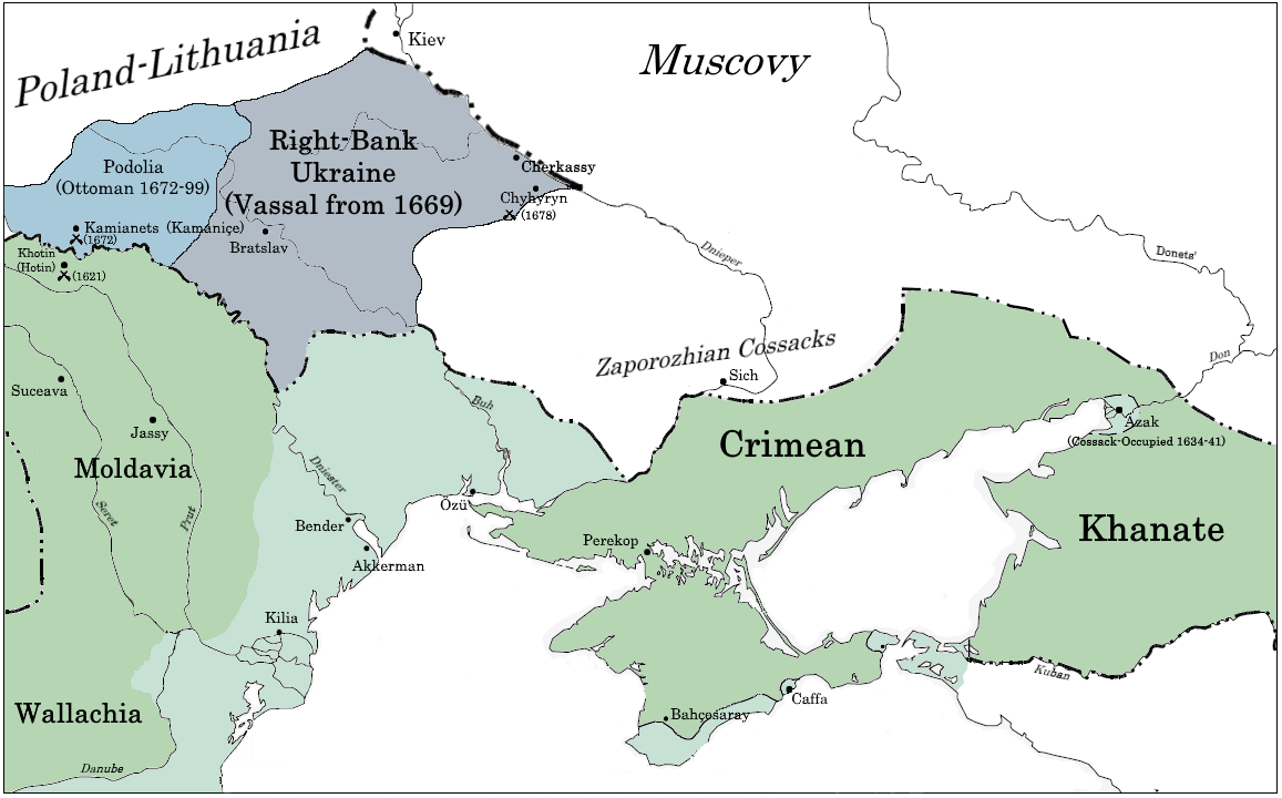
The Treaty of Bakhchisarai or Treaty of Radzin, (russian: Бахчисарайский мирный договор; tr, Bahçesaray Antlaşması) was signed in Bakhchisaray, which ended the Russo-Turkish War (1676–1681), on 3 January 1681 by Russia, the Ottoman Empire, and the Crimean Khanate. They agreed to a 20-year truce and had accepted the Dnieper River as the demarcation line between the Ottoman Empire and Moscow's domain. All sides agreed not to settle the territory between the Southern Bug and Dnieper rivers. After the signing of the treaty, the Nogai hordes still retained the right to live as nomads in the southern steppes of Ukraine, while the Cossacks retained the right to fish in the Dnieper and its tributaries; to obtain salt in the south; and to sail on the Dnieper and the Black Sea. The Ottoman sultan then recognized Muscovy's sovereignty in the Left-bank Ukraine region and the Zaporozhian Cossack domain, while the southern part of the Kiev region, the Bratslav r ... [...More Info...] [...Related Items...] OR: [Wikipedia] [Google] [Baidu] |
Bakhchisaray
Bakhchysarai ( crh, Bağçasaray, italic=yes; russian: Бахчисара́й; ua, Бахчисара́й; tr, Bahçesaray) is a town in Crimea, a territory recognized by a majority of countries as part of Ukraine and annexed by Russia as the Republic of Crimea. It is the administrative center of the Bakhchysarai Raion (district), as well as the former capital of the Crimean Khanate. Its main landmark is Hansaray, the only extant palace of the Crimean Khans, currently open to tourists as a museum. Population: Geography Bakhchysarai lies in a narrow valley of the river, about 30 Kilometers south-west of Simferopol. History The earliest known artifacts of human provenance found in the valley date from the Mesolithic period. Settlements have existed in the valley since Late Antiquity. The founding of Bakhchysarai was preceded by the Qırq Yer fortress (modern Çufut Qale), Salaçıq, and Eski Yurt — these have become incorporated into the urban area of modern Bakhchysarai ... [...More Info...] [...Related Items...] OR: [Wikipedia] [Google] [Baidu] |
Bratslav
Bratslav ( uk, Брацлав; pl, Bracław; yi, בראָצלעוו, ''Brotslev'', today also pronounced Breslev or '' Breslov'' as the name of a Hasidic group, which originated from this town) is an urban-type settlement in Ukraine, located in Tulchyn Raion of Vinnytsia Oblast, by the Southern Bug river. It is a medieval European city and a regional center of the Eastern Podolia region (see Bratslav Voivodeship) founded by government of the Crown of the Kingdom of Poland, which dramatically lost its importance during the 19th-20th centuries. Population: History The first written mention of Bratslav dates back to 1362. City status was granted Magdeburg Rights in 1564. Bratslav belonged to the Grand Duchy of Lithuania until the Lublin Union of 1569, when it became a voivodeship center in the Crown of the Kingdom of Poland as part of the Polish–Lithuanian Commonwealth. In the early 16th century, the Starosta of Bratslav and Vinnytsia (Winnica) was Hetman Kostiantyn Ostrozky ... [...More Info...] [...Related Items...] OR: [Wikipedia] [Google] [Baidu] |
Crimean Tatars
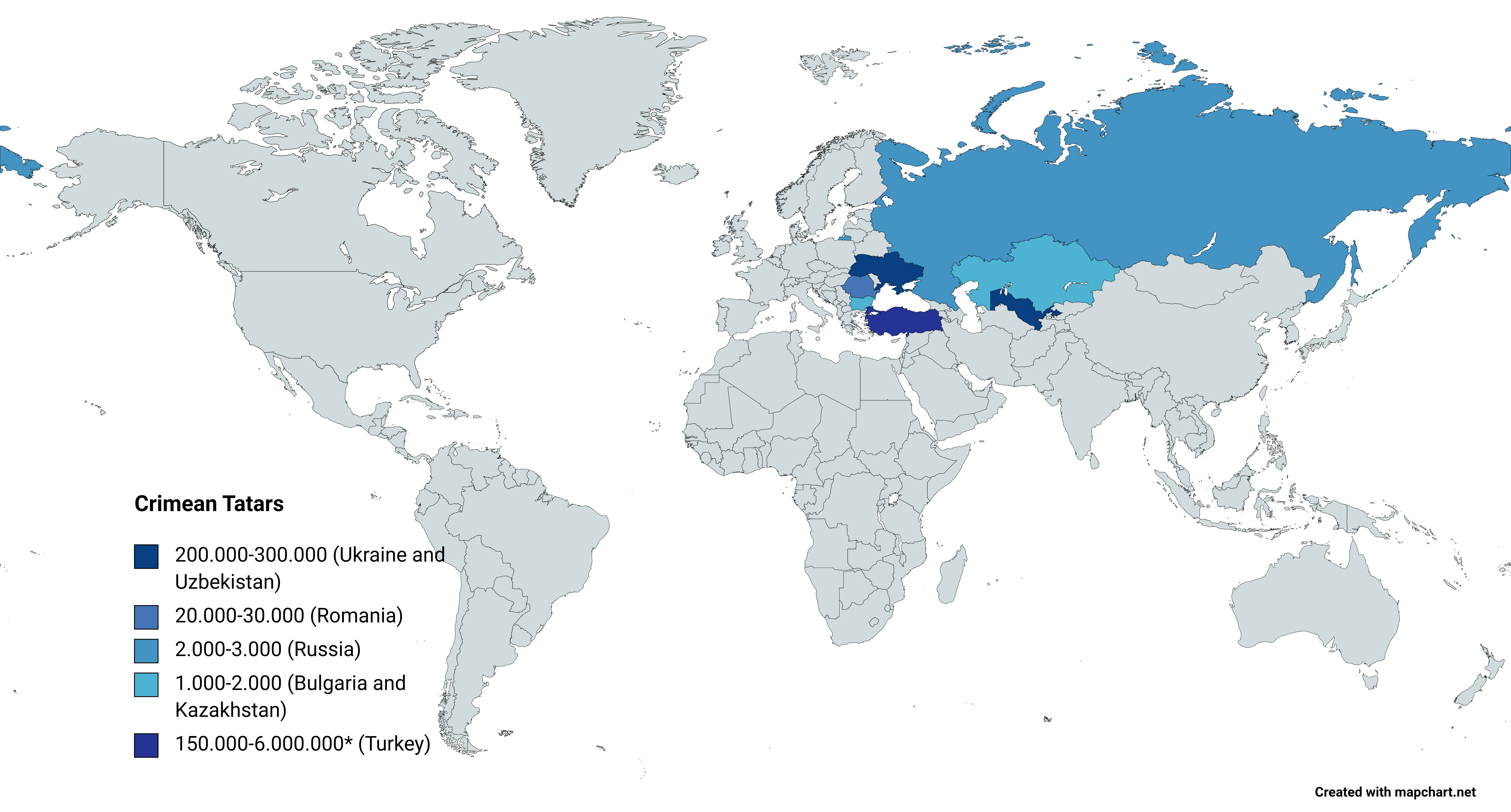
, flag = Flag of the Crimean Tatar people.svg , flag_caption = Flag of Crimean Tatars , image = Love, Peace, Traditions.jpg , caption = Crimean Tatars in traditional clothing in front of the Khan's Palace , poptime = , popplace = , region1 = , pop1 = 3,500,000 6,000,000 , ref1 = , region2 = * , pop2 = 248,193 , ref2 = , region3 = , pop3 = 239,000 , ref3 = , region4 = , pop4 = 24,137 , ref4 = , region5 = , pop5 = 2,449 , ref5 = , region7 = , pop7 = 1,803 , ref7 = , region8 = , pop8 = 1,532 , ref8 = , region9 = *() , pop9 = 7,000(500–1,000) , ref9 = , region10 = Total , pop10 = 4.024.114 (or 6.524.11 ... [...More Info...] [...Related Items...] OR: [Wikipedia] [Google] [Baidu] |
Sultan Of The Ottoman Empire
The sultans of the Ottoman Empire ( tr, Osmanlı padişahları), who were all members of the Ottoman dynasty (House of Osman), ruled over the transcontinental empire from its perceived inception in 1299 to its dissolution in 1922. At its height, the Ottoman Empire spanned an area from Hungary in the north to rebel in the south and from Algeria in the west to Iraq in the east. Administered at first from the city of Söğüt since before 1280 and then from the city of Bursa since 1323 or 1324, the empire's capital was moved to Adrianople (now known as Edirne in English) in 1363 following its conquest by Murad I and then to Constantinople (present-day Istanbul) in 1453 following its conquest by Mehmed II. The Ottoman Empire's early years have been the subject of varying narratives, due to the difficulty of discerning fact from legend. The empire came into existence at the end of the 13th century, and its first ruler (and the namesake of the Empire) was Osman I. According to ... [...More Info...] [...Related Items...] OR: [Wikipedia] [Google] [Baidu] |
Chyhyryn
Chyhyryn ( uk, Чигирин, ) is a city and historic site located in Cherkasy Raion of Cherkasy Oblast of central Ukraine. From 1648 to 1669 the city was a Hetman residence. After a forced relocation of the Ruthenian Orthodox metropolitan see from Kyiv in 1658, it became a full-fledged capital of the Cossack Hetmanate. Chyhyryn also became a traditional place for the appointment to the office of Hetman of Zaporizhian Host. It hosts the administration of Chyhyryn urban hromada, one of the hromadas of Ukraine. Population: Names Chyhyryn ( uk, Чигирин; Turkish: ''Çigirin'' or ''Çehrin''; russian: Чигирин) pl, Czehryń). Location The city is on the banks of Tiasmyn River and lies at an altitude of 124 metres above mean sea level. Minor industries, such as food and furniture factories, are the basis of the town economy in the 21st century. History The area (1320–1569) had been part of the Grand Duchy of Lithuania. It was ceded to the Polish–Lithuanian ... [...More Info...] [...Related Items...] OR: [Wikipedia] [Google] [Baidu] |
Right-bank Ukraine
Right-bank Ukraine ( uk , Правобережна Україна, ''Pravoberezhna Ukrayina''; russian: Правобережная Украина, ''Pravoberezhnaya Ukraina''; pl, Prawobrzeżna Ukraina, sk, Pravobrežná Ukrajina, hu, Jobb parti Ukrajna) is a historical and territorial name for a part of modern Ukraine on the right (west) bank of the Dnieper River, corresponding to the modern-day oblasts of Vinnytsia, Zhytomyr, Kirovohrad, as well as the western parts of Kyiv and Cherkasy. It was separated from the left bank during the Ruin. Right-bank Ukraine is bordered by the historical regions of Volhynia and Podolia to the west, Moldavia to the southwest, Yedisan and Zaporizhzhia to the south, left-bank Ukraine to the east, and Polesia to the north. Main cities of the region include Cherkasy, Kropyvnytskyi, Bila Tserkva, Zhytomyr and Oleksandriia. History The history of right- and left-bank Ukraine is closely associated with the Khmelnytsky Uprising of 1648–57. The ... [...More Info...] [...Related Items...] OR: [Wikipedia] [Google] [Baidu] |
Radomyshl
Radomyshl ( uk, Радомишль, translit., ''Radomyshl’'', pl, Radomyśl, yi, ראַדאָמישל, russian: Радомышль) is a historic city in Zhytomyr Raion, Zhytomyr Oblast (province) of northern Ukraine. Prior to 2020, it was the administrative center of the former Radomyshl Raion (district), and is located on the left bank of the Teteriv River, a right tributary of the Dnieper. Its population is approximately . It is located within the historic region of Right-bank Ukraine. History Since 1150, it was known as Mychesk. The settlement probably was destroyed during the Mongol invasion in 1240, after which the region fell under Mongol suzerainty. In the 14th century it became part of Lithuania and subsequently the Polish–Lithuanian union after the Union of Krewo (1385). The town was raided by Tatars in 1399, 1416 and 1462. As part of the Kingdom of Poland from 1569 it was known under the name of Radomyśl. Administratively it was part of the Kyiv Voivodeship ... [...More Info...] [...Related Items...] OR: [Wikipedia] [Google] [Baidu] |
Vasylkiv
Vasylkiv (, uk, Васильків, lit=, translit=Vasylʹkiv, yi, וואַסלקעוו, Vasilikev) is a city located on the Stuhna River in Obukhiv Raion, Kyiv Oblast (province) in central Ukraine. It hosts the administration of Vasylkiv urban hromada, one of the hromadas of Ukraine. A settlement with an over 1000 years history, Vasylkiv was incorporated as a city in 1796. The city has hosted the Vasylkiv Air Base since the Cold War. It is currently an industrial centre, producing electrical appliances and leather goods. Population: History Vasylkiv was founded in 988 CE, and fortified in the 11th century. According to the Primary Chronicle, it was the place where Vladimir the Great's numerous wives lived. After the Christianization of Kyiv, Vladimir built there a fortress and named it ''Vasilev'', after his patron saint, Saint Basil (Vasily). In the early 11th century, it was the birthplace of Saint Theodosius of Kiev. The Anthony and Theodosius Pechersky Church, built in ... [...More Info...] [...Related Items...] OR: [Wikipedia] [Google] [Baidu] |
Trypillia
Trypillia ( ua , Трипiлля) is a selo in Obukhiv Raion (district) of Kyiv Oblast in central Ukraine, with 2,800 inhabitants (as of 1 January 2005). It belongs to Ukrainka urban hromada, one of the hromadas of Ukraine. Trypillia lies about south from Kyiv on the Dnipro. Trypillia is the site of an ancient mega-settlement dating to 4300–4000 BCE belonging to the Cucuteni-Trypillian culture. Settlements of this culture were as large as 200 hectares. This proto-city is just one of 2440 Cucuteni-Trypillia settlements discovered so far in Moldova and Ukraine. 194 (8%) of these settlements had an area of more than 10 hectares between 5000–2700 BCE and more than 29 settlements had an area in the range 100–450 hectares. History It was near Trypillia that archaeologist Vikentiy Khvoyka discovered an extensive Neolithic site of the Cucuteni-Trypillian culture, one of the major Neolithic-Chalcolithic cultures of eastern Europe. Khvoika reported his findings in 1897 ... [...More Info...] [...Related Items...] OR: [Wikipedia] [Google] [Baidu] |
Stajki
{{Łuków-geo-stub ...
Stajki is a settlement in the administrative district of Gmina Stanin, within Łuków County, Lublin Voivodeship, in eastern Poland. It lies approximately east of Stanin, south-west of Łuków, and north of the regional capital Lublin. References Stajki Stajki is a settlement in the administrative district of Gmina Stanin, within Łuków County, Lublin Voivodeship, in eastern Poland. It lies approximately east of Stanin, south-west of Łuków Łuków is a city in eastern Poland with 30,72 ... [...More Info...] [...Related Items...] OR: [Wikipedia] [Google] [Baidu] |
Dnipro
Dnipro, previously called Dnipropetrovsk from 1926 until May 2016, is Ukraine's fourth-largest city, with about one million inhabitants. It is located in the eastern part of Ukraine, southeast of the Ukrainian capital Kyiv on the Dnieper River, after which its Ukrainian language name (Dnipro) it is named. Dnipro is the Capital (political), administrative centre of the Dnipropetrovsk Oblast. It hosts the administration of Dnipro urban hromada. The population of Dnipro is Archeological evidence suggests the site of the present city was settled by Cossack communities from at least 1524. The town, named Yekaterinoslav (''the glory of Catherine''), was established by decree of the Emperor of all the Russias, Russian Empress Catherine the Great in 1787 as the administrative center of Novorossiya Governorate, Novorossiya. From the end of the nineteenth century, the town attracted foreign capital and an international, multi-ethnic, workforce exploiting Kryvbas iron ore and Donbas coa ... [...More Info...] [...Related Items...] OR: [Wikipedia] [Google] [Baidu] |


.jpg)