|
Tolokiwa Island
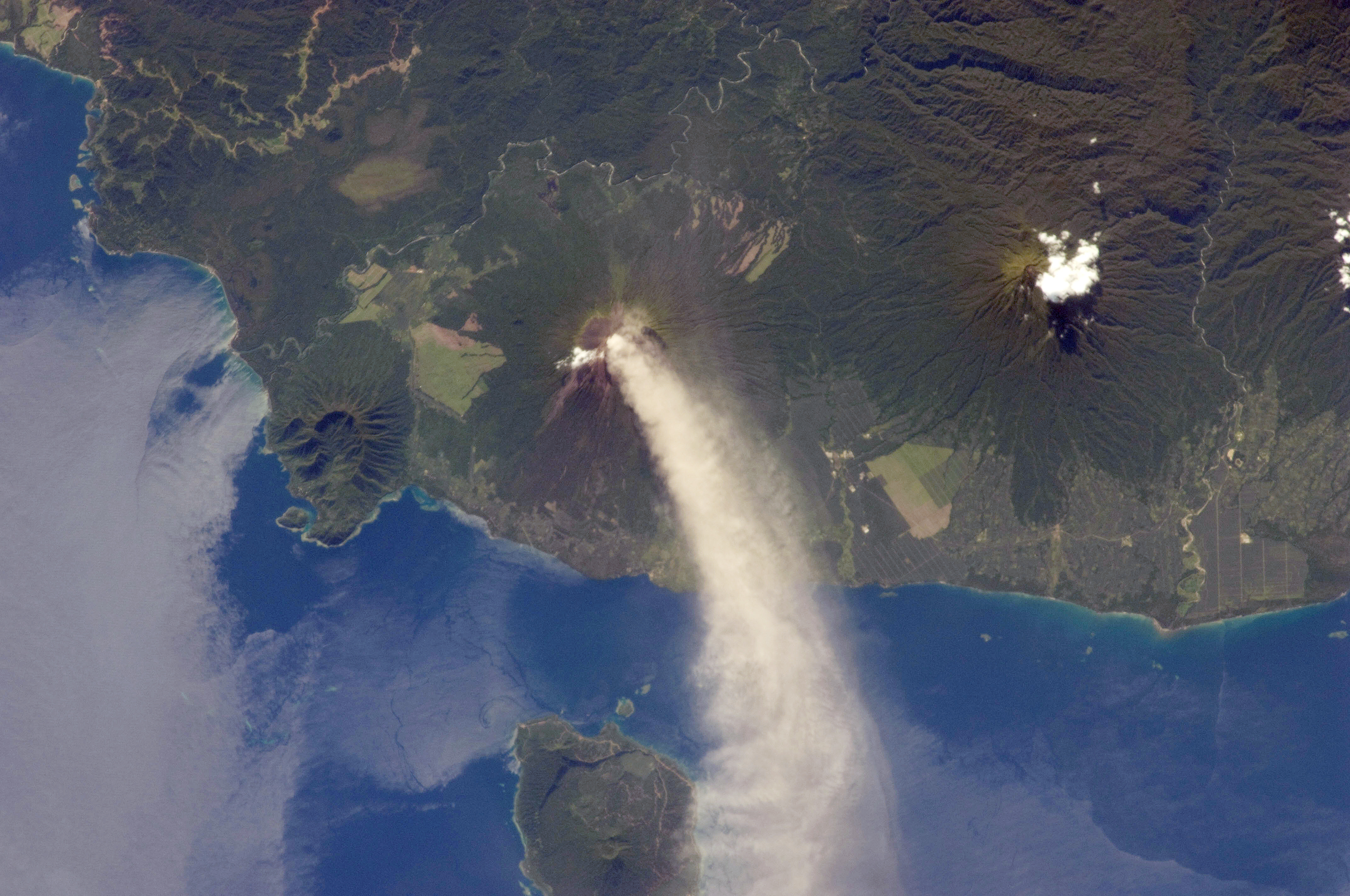
Tolokiwa Island, also known as Lottin Island, is an island in the Bismarck Sea. The island is volcanic in origin and part of the Bismarck Archipelago. Description Tolokiwa Island was built up by a series of volcanic eruptions during the Pleistocene epoch. The well-vegetated island is an important natural site for birds, and is home to several species of resident birds (which it unusually shares with nearby islands). Tolokiwa is also home to a subspecies of Turdus Poliocephalus. The island sustained damage during the 1888 eruption of nearby Ritter Island Ritter Island is a small crescent-shaped volcanic island north-east of New Guinea, situated between Umboi Island and Sakar Island. There are several recorded eruptions of this basaltic-andesitic stratovolcano prior to a spectacular lateral coll ..., which caused a tsunami to hit Tolokiwa. References Bismarck Archipelago Islands of Papua New Guinea {{Island-stub ... [...More Info...] [...Related Items...] OR: [Wikipedia] [Google] [Baidu] |
Papua New Guinea
Papua New Guinea (abbreviated PNG; , ; tpi, Papua Niugini; ho, Papua Niu Gini), officially the Independent State of Papua New Guinea ( tpi, Independen Stet bilong Papua Niugini; ho, Independen Stet bilong Papua Niu Gini), is a country in Oceania that comprises the eastern half of the island of New Guinea and its offshore islands in Melanesia (a region of the southwestern Pacific Ocean north of Australia). Its capital, located along its southeastern coast, is Port Moresby. The country is the world's third largest island country, with an area of . At the national level, after being ruled by three external powers since 1884, including nearly 60 years of Australian administration starting during World War I, Papua New Guinea established its sovereignty in 1975. It became an independent Commonwealth realm in 1975 with Elizabeth II as its queen. It also became a member of the Commonwealth of Nations in its own right. There are 839 known languages of Papua New Guinea, one of ... [...More Info...] [...Related Items...] OR: [Wikipedia] [Google] [Baidu] |
Bismark Archipelago
The Bismarck Archipelago (, ) is a group of islands off the northeastern coast of New Guinea in the western Pacific Ocean and is part of the Islands Region of Papua New Guinea. Its area is about 50,000 square km. History The first inhabitants of the archipelago arrived around 30–40,000 years ago. They may have traveled from New Guinea, by boat across the Bismarck Sea or via a temporary land bridge, created by an uplift in the Earth's crust. Later arrivals included the Lapita people. The first European to visit these islands was Dutch explorer Willem Schouten in 1616. The islands remained unsettled by western Europeans until they were annexed as part of the German protectorate of German New Guinea in 1884. The area was named in honour of the Chancellor Otto von Bismarck. On 13 March 1888, a volcano erupted on Ritter Island causing a megatsunami. Almost the entire volcano fell into the ocean, leaving a small crater lake. Following the outbreak of World War I, the Austr ... [...More Info...] [...Related Items...] OR: [Wikipedia] [Google] [Baidu] |
Bismarck Sea
The Bismarck Sea (, ) lies in the southwestern Pacific Ocean within the nation of Papua New Guinea. It is located northeast of the island of New Guinea and south of the Bismarck Archipelago. It has coastlines in districts of the Islands Region, Momase Region, and Papua Region. Geography Like the Bismarck Archipelago, it is named in honour of the first German Chancellor Otto von Bismarck. The Bismarck Archipelago extends round to the east and north of the sea, enclosing the Bismarck Sea and separating it from the Southern Pacific Ocean. To the south it is linked to the Solomon Sea by the Vitiaz Strait. Official boundaries The International Hydrographic Organization defines the Bismarck Sea as "that area of the Pacific Ocean, South Pacific Ocean off the northeast coast of New Guinea", with the following limits: ''On the North and East.'' By the Northern and Northeastern coasts of the islands of New Ireland (island), New Ireland, New Hanover Island, New Hanover, the Admiralty I ... [...More Info...] [...Related Items...] OR: [Wikipedia] [Google] [Baidu] |
Bismarck Archipelago
The Bismarck Archipelago (, ) is a group of islands off the northeastern coast of New Guinea in the western Pacific Ocean and is part of the Islands Region of Papua New Guinea. Its area is about 50,000 square km. History The first inhabitants of the archipelago arrived around 30–40,000 years ago. They may have traveled from New Guinea, by boat across the Bismarck Sea or via a temporary land bridge, created by an uplift in the Earth's Crust (geology), crust. Later arrivals included the Lapita people. The first European to visit these islands was Dutch explorer Willem Schouten in 1616. The islands remained unsettled by western Europeans until they were annexed as part of the German protectorate of German New Guinea in 1884. The area was named in honour of the Chancellor of Germany (German Reich), Chancellor Otto von Bismarck. On 1888 Ritter Island eruption and tsunami, 13 March 1888, a volcano erupted on Ritter Island causing a megatsunami. Almost the entire volcano fell into t ... [...More Info...] [...Related Items...] OR: [Wikipedia] [Google] [Baidu] |
Pleistocene
The Pleistocene ( , often referred to as the ''Ice age'') is the geological Epoch (geology), epoch that lasted from about 2,580,000 to 11,700 years ago, spanning the Earth's most recent period of repeated glaciations. Before a change was finally confirmed in 2009 by the International Union of Geological Sciences, the cutoff of the Pleistocene and the preceding Pliocene was regarded as being 1.806 million years Before Present (BP). Publications from earlier years may use either definition of the period. The end of the Pleistocene corresponds with the end of the last glacial period and also with the end of the Paleolithic age used in archaeology. The name is a combination of Ancient Greek grc, label=none, πλεῖστος, pleīstos, most and grc, label=none, καινός, kainós (latinized as ), 'new'. At the end of the preceding Pliocene, the previously isolated North and South American continents were joined by the Isthmus of Panama, causing Great American Interchang ... [...More Info...] [...Related Items...] OR: [Wikipedia] [Google] [Baidu] |
Turdus Poliocephalus
The island thrush (''Turdus poliocephalus'') is a common forest bird in the thrush family. Almost 50 subspecies have been described, ranging from South East Asia and Melanesia, to Samoa, exhibiting great differences in plumage. Several subspecies are threatened and three have already become extinct. Taxonomy The island thrush is a member of the cosmopolitan genus ''Turdus'' (Linnaeus, 1758), one of the most widely distributed bird genera in the world. The taxonomy of the island thrush is complex, and has defied attempts to split the group based on the four suspected morphological types. There are also thought to be at least two further subspecies not yet described scientifically, both from the Indonesian island of Sulawesi. List of subspecies The list below is sorted alphabetically. * ''T. p. albifrons'' ( Edward Pierson Ramsay, E. P. Ramsay, 1879). Erromango, Vanuatu. * ''T. p. becki'' Mayr, 1941. Paama, Lopevi, Epi and Emae, in Vanuatu. * ''T. p. beehleri'' Ripley, 1977. ... [...More Info...] [...Related Items...] OR: [Wikipedia] [Google] [Baidu] |
1888 Ritter Island Eruption And Tsunami
On the morning of March 13, 1888, an explosion took place on Ritter Island, a small volcanic island in the Bismarck and Solomon Seas, between New Britain and Umboi Island. This event is the largest volcanic island sector collapse in recent history. The explosion resulted in the almost complete loss of the island and generated a tsunami with runups of up to that caused damage more than away and killed anywhere between 500 and 3,000 on neighbouring islands, including scientists and explorers. Background Ritter Island in the Bismarck Archipelago is an active stratovolcano located off the northeast coast of Papua New Guinea. It is one of the many active volcanoes in Papua New Guinea as a result of subduction of the Solomon Sea Plate beneath the Bismarck Plate along the New Britain Trench. This process has also resulted in earthquakes both on the subduction zone and within the two tectonic plates. A magnitude 8.1 earthquake in Morobe Province, for example, occurred as a result ... [...More Info...] [...Related Items...] OR: [Wikipedia] [Google] [Baidu] |
Ritter Island
Ritter Island is a small crescent-shaped volcanic island north-east of New Guinea, situated between Umboi Island and Sakar Island. There are several recorded eruptions of this basaltic-andesitic stratovolcano prior to a spectacular lateral collapse which took place in 1888. Before that event, it was a circular conical island about high. 1888 eruption At about 5:30 am local time on 13 March 1888 a large portion of the island, containing perhaps of material slid into the sea during a relatively minor, possibly VEI 2, phreatic eruption. Eyewitnesses at Finschhafen, to the south, heard explosions and observed an almost imperceptible ash fall. Tsunamis high were generated by the collapse and devastated nearby islands and the adjacent New Guinea coast killing around 3,000 people. The collapse left a high, long crescent-shaped island with a steep west-facing escarpment. At least two small eruptions have occurred offshore since 1888, one in 1972 and another in 1974, whi ... [...More Info...] [...Related Items...] OR: [Wikipedia] [Google] [Baidu] |


_2012.png)


