|
Tionontati
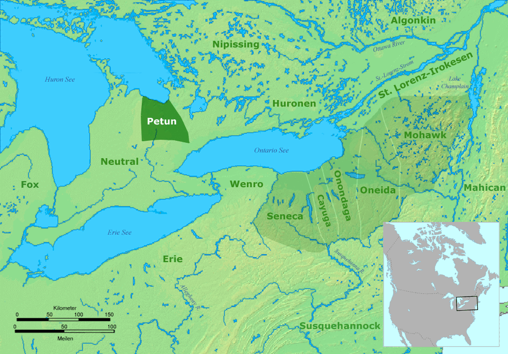
The Petun (from french: wiktionary:pétun, pétun), also known as the Tobacco people or Tionontati ("People Among the Hills/Mountains"), were an Indigenous peoples of the Americas, indigenous Iroquoian peoples, Iroquoian people of the woodlands of eastern North America. Their last known traditional homeland was south of Lake Huron's Georgian Bay, in what is today's Canadian province of Ontario The Petun were closely related to the Wyandot people, Huron, or Wendat. Similarly to other Iroquoian peoples, they were structured as a confederacy. One of the less numerous Iroquoian peoples when they became known to Europeans, they had eight or nine villages in the early 17th century, and are estimated to have numbered around 8000 prior to European contact. A number of disease epidemics were documented in Huron–Petun societies between 1634 and 1640, which have been linked to the arrival of settlers from urban Europe; this decimated their population. Although they each spoke Iroquoian ... [...More Info...] [...Related Items...] OR: [Wikipedia] [Google] [Baidu] |
Wyandot People
The Wyandot people, or Wyandotte and Waⁿdát, are Indigenous peoples of the Northeastern Woodlands. The Wyandot are Iroquoian Indigenous peoples of North America who emerged as a confederacy of tribes around the north shore of Lake Ontario with their original homeland extending to Georgian Bay of Lake Huron and Lake Simcoe in Ontario, Canada and occupying some territory around the western part of the lake. The Wyandot, not to be mistaken for the Huron-Wendat, predominantly descend from the Tionontati tribe. The Tionontati (or Tobacco/Petun people) never belonged to the Huron (Wendat) Confederacy. However, the Wyandot(te) have connections to the Wendat-Huron through their lineage from the Attignawantan, the founding tribe of the Huron. The four Wyandot(te) Nations are descended from remnants of the Tionontati, Attignawantan and Wenrohronon (Wenro), that were "all unique independent tribes, who united in 1649-50 after being defeated by the Iroquois Confederacy." After thei ... [...More Info...] [...Related Items...] OR: [Wikipedia] [Google] [Baidu] |
Neutral Nation
The Neutral Confederacy (also Neutral Nation, Neutral people, or ''Attawandaron'' by neighbouring tribes) were an Iroquoian people who lived in what is now southwestern and south-central Ontario in Canada, North America. They lived throughout the area bounded by the southern half of Lake Huron, the entire northern shoreline of Lake Erie, from the Detroit River in the west to the Niagara River in the east, plus northward around the western end of Lake Ontario. Their territory was southwest of the Petun and west of the southern area of the Huron people, or Wendat territory. They were related to other Iroquoian-language speakers: the Huron people, the Petun (who later merged with the Huron), the Wenro to their east, and the Five Nations of the Iroquois Confederation further to the east, as well as to the Erie people of the south shore of Lake Erie, and the Susquehannock of Central Pennsylvania. Like others of Iroquoian language and culture, the tribes would raid and feud wit ... [...More Info...] [...Related Items...] OR: [Wikipedia] [Google] [Baidu] |
Georgian Bay
Georgian Bay (french: Baie Georgienne) is a large bay of Lake Huron, in the Laurentia bioregion. It is located entirely within the borders of Ontario, Canada. The main body of the bay lies east of the Bruce Peninsula and Manitoulin Island. To its northwest is the North Channel. Georgian Bay is surrounded by (listed clockwise) the districts of Manitoulin, Sudbury, Parry Sound and Muskoka, as well as the more populous counties of Simcoe, Grey and Bruce. The Main Channel separates the Bruce Peninsula from Manitoulin Island and connects Georgian Bay to the rest of Lake Huron. The North Channel, located between Manitoulin Island and the Sudbury District, west of Killarney, was once a popular route for steamships and is now used by a variety of pleasure craft to travel to and from Georgian Bay. The shores and waterways of the Georgian Bay are the traditional domain of the Anishinaabeg First Nations peoples to the north and Huron-Petun (Wyandot) to the south. The bay was thus a ma ... [...More Info...] [...Related Items...] OR: [Wikipedia] [Google] [Baidu] |
Petun Map
The Petun (from french: pétun), also known as the Tobacco people or Tionontati ("People Among the Hills/Mountains"), were an indigenous Iroquoian people of the woodlands of eastern North America. Their last known traditional homeland was south of Lake Huron's Georgian Bay, in what is today's Canadian province of Ontario The Petun were closely related to the Huron, or Wendat. Similarly to other Iroquoian peoples, they were structured as a confederacy. One of the less numerous Iroquoian peoples when they became known to Europeans, they had eight or nine villages in the early 17th century, and are estimated to have numbered around 8000 prior to European contact. A number of disease epidemics were documented in Huron–Petun societies between 1634 and 1640, which have been linked to the arrival of settlers from urban Europe; this decimated their population. Although they each spoke Iroquoian languages, they were independent of the Five Nations of the Iroquois Confederacy (Haudeno ... [...More Info...] [...Related Items...] OR: [Wikipedia] [Google] [Baidu] |
Longhouse
A longhouse or long house is a type of long, proportionately narrow, single-room building for communal dwelling. It has been built in various parts of the world including Asia, Europe, and North America. Many were built from timber and often represent the earliest form of permanent structure in many cultures. Types include the Neolithic long house of Europe, the Norman Medieval Longhouses that evolved in Western Briton (''Tŷ Hir)'' and Northern France (''Longère)'' and the various types of longhouse built by different cultures among the indigenous peoples of the Americas. Europe *The Neolithic long house type was introduced with the first farmers of central and western Europe around 5000 BCE, 7,000 years ago. These were farming settlements built in groups of six to twelve and were home to large extended families and kin. *The Germanic cattle-farmer longhouses emerged along the southwestern North Sea coast in the third or fourth century BCE and may be the ancestors of sever ... [...More Info...] [...Related Items...] OR: [Wikipedia] [Google] [Baidu] |
Cayuga People
The Cayuga ( Cayuga: Gayogo̱hó꞉nǫʼ, "People of the Great Swamp") are one of the five original constituents of the Haudenosaunee (Iroquois), a confederacy of Native Americans in New York. The Cayuga homeland lies in the Finger Lakes region along Cayuga Lake, between their league neighbors, the Onondaga to the east and the Seneca to the west. Today Cayuga people belong to the Six Nations of the Grand River First Nation in Ontario, and the federally recognized Cayuga Nation of New York and the Seneca-Cayuga Tribe of Oklahoma. History Political relations between the Cayuga, the British, and the Thirteen Colonies during the American Revolution were complicated and variable, with Cayuga warriors fighting on both sides (as well as abstaining from war entirely). Most of the Iroquois nations allied with the British, in part hoping to end encroachment on their lands by colonists. In 1778, various Iroquois bands, oft allied with British-colonial loyalists (Tories) conducted a ... [...More Info...] [...Related Items...] OR: [Wikipedia] [Google] [Baidu] |
Nottawasaga Bay
Nottawasaga Bay is a sub- bay within Georgian Bay in Southern Ontario, Canada located at the southernmost end of the main bay. The communities located on Nottawasaga Bay are Meaford, The Blue Mountains, Collingwood, Wasaga Beach and Tiny. The western shore of Nottawasaga Bay is determined by the Niagara Escarpment, which reaches Nottawasaga Bay between Collingwood and Thornbury. The southern shore is flat limestone plain, with cedar marshes. The Nottawasaga River flows into Georgian Bay near the southern end of the bay, and onward to the east the shore is predominantly sand dunes and marshes created by the strong predominant northwest winds. This part of Nottawasaga Bay is heavily built up with summer homes. Nearer to Thornbury and the Beaver River Valley there are some vineyards; many apple orchards also dot the area. The river takes its name from the Ojibwe word "Nottawasaga". ''Nottawa'' (or ''Naadowe'' in modern orthography) means "Iroquois" and ''saga'' (''zaagi'' in ... [...More Info...] [...Related Items...] OR: [Wikipedia] [Google] [Baidu] |
Huronia (region)
Huronia is a historical region in the Great Lakes area of eastern North America. It is positioned between Lakes Erie, Ontario, and Huron. Similarly to the latter, it takes its name from the Huron, an Iroquoian society that flourished in the years leading up to contact with Europeans. The term Huronia, which was coined by later Europeans, is distinct from the term the Huron themselves used for their dwelling place, which is ("the peninsula country"). Other translations suggested are "the island apart", "the separate country", "the country with a separate language", "the one village", or "the villagers." At the time of first European contact, Wendake was "one of the most densely populated territories north of Mexico." It consisted of twenty to twenty-five settlements occupying about between Nottawasaga Bay and Lake Simcoe West to East, and Matchedash Bay and the swampy basin of the Nottawasaga River, North to South. The population was estimated to be 20-30 thousand. Following th ... [...More Info...] [...Related Items...] OR: [Wikipedia] [Google] [Baidu] |
Smithsonian Institute
The Smithsonian Institution ( ), or simply the Smithsonian, is a group of museums and education and research centers, the largest such complex in the world, created by the U.S. government "for the increase and diffusion of knowledge". Founded on August 10, 1846, it operates as a trust instrumentality and is not formally a part of any of the three branches of the federal government. The institution is named after its founding donor, British scientist James Smithson. It was originally organized as the United States National Museum, but that name ceased to exist administratively in 1967. Called "the nation's attic" for its eclectic holdings of 154 million items, the institution's 19 museums, 21 libraries, nine research centers, and zoo include historical and architectural landmarks, mostly located in the District of Columbia. Additional facilities are located in Maryland, New York, and Virginia. More than 200 institutions and museums in 45 states,States without Smithsonian A ... [...More Info...] [...Related Items...] OR: [Wikipedia] [Google] [Baidu] |
Jesuit Relations
''The Jesuit Relations'', also known as ''Relations des Jésuites de la Nouvelle-France'', are chronicles of the Jesuit missions in New France. The works were written annually and printed beginning in 1632 and ending in 1673. Originally written in French, Latin, and Italian, ''The Jesuit Relations'' were reports from Jesuit missionaries in the field to their superiors to update them as to the missionaries' progress in the conversion of various Indigenous North American tribes, including the Huron, Montagnais, Mi ' kmaq, Mohawk, and Algonquins. Constructed as narratives, the original reports of the Jesuit missionaries were subsequently transcribed and altered several times before their publication, first by the Jesuit overseer in New France and then by the Jesuit governing body in France. The Jesuits began to shape the ''Relations'' for the general public, in order to attract new settlers to the colony and to raise enough capital to continue the missions in New France. Overall, ... [...More Info...] [...Related Items...] OR: [Wikipedia] [Google] [Baidu] |
West Virginia
West Virginia is a state in the Appalachian, Mid-Atlantic and Southeastern regions of the United States.The Census Bureau and the Association of American Geographers classify West Virginia as part of the Southern United States while the Bureau of Labor Statistics classifies the state as a part of the Mid-Atlantic regionMid-Atlantic Home : Mid-Atlantic Information Office: U.S. Bureau of Labor Statistics" www.bls.gov. Archived. It is bordered by Pennsylvania to the north and east, Maryland to the east and northeast, Virginia to the southeast, Kentucky to the southwest, and Ohio to the northwest. West Virginia is the 10th-smallest state by area and ranks as the 12th-least populous state, with a population of 1,793,716 residents. The capital and largest city is Charleston. West Virginia was admitted to the Union on June 20, 1863, and was a key border state during the American Civil War. It was the only state to form by separating from a Confederate state, the second to sepa ... [...More Info...] [...Related Items...] OR: [Wikipedia] [Google] [Baidu] |
Guyandotte River
The Guyandotte River is a tributary of the Ohio River, approximately 166 mi (267 km) long, in southwestern West Virginia in the United States. It was named after the French term for the Wendat Native Americans. It drains an area of the unglaciated Allegheny Plateau south of the Ohio between the watersheds of the Kanawha River to the northeast and Twelvepole Creek and the Big Sandy River to the southwest. Via the Ohio River, it is part of the Mississippi River watershed. Course The Guyandotte River is formed in southwestern Raleigh County by the confluence of three streams, Winding Gulf, Stonecoal Creek, and the Devils Fork. The Guyandotte flows initially west-northwestwardly into Wyoming and Mingo counties. It turns briefly northward in Mingo County and enters Logan County, where it turns north-northwestwardly for the remainder of its highly meandering course through Logan, Lincoln and Cabell counties. It enters the Ohio River from the south at Huntington, ab ... [...More Info...] [...Related Items...] OR: [Wikipedia] [Google] [Baidu] |


