|
Tillie, Pennsylvania
Tillie was a populated place east of Orrtanna and south oMcKnightstownthat was the site of the McKnightstown railroad station on the Hanover Junction, Hanover and Gettysburg Railroad east of Orr Station and west oSeven Starsstation after the railroad line was extended west from Gettysburg, Pennsylvania Gettysburg (; non-locally ) is a borough and the county seat of Adams County in the U.S. state of Pennsylvania. The Battle of Gettysburg (1863) and President Abraham Lincoln's Gettysburg Address are named for this town. Gettysburg is home to th ..., in 1884 and west of Marsh Creek in 1885. References {{authority control Geography of Adams County, Pennsylvania Former populated places in Pennsylvania ... [...More Info...] [...Related Items...] OR: [Wikipedia] [Google] [Baidu] |
Unincorporated Area
An unincorporated area is a region that is not governed by a local municipal corporation. Widespread unincorporated communities and areas are a distinguishing feature of the United States and Canada. Most other countries of the world either have no unincorporated areas at all or these are very rare: typically remote, outlying, sparsely populated or List of uninhabited regions, uninhabited areas. By country Argentina In Argentina, the provinces of Chubut Province, Chubut, Córdoba Province (Argentina), Córdoba, Entre Ríos Province, Entre Ríos, Formosa Province, Formosa, Neuquén Province, Neuquén, Río Negro Province, Río Negro, San Luis Province, San Luis, Santa Cruz Province, Argentina, Santa Cruz, Santiago del Estero Province, Santiago del Estero, Tierra del Fuego Province, Argentina, Tierra del Fuego, and Tucumán Province, Tucumán have areas that are outside any municipality or commune. Australia Unlike many other countries, Australia has only local government in Aus ... [...More Info...] [...Related Items...] OR: [Wikipedia] [Google] [Baidu] |
Adams County, Pennsylvania
Adams County is a county in the Commonwealth of Pennsylvania. As of the 2020 census, the population was 103,852. Its county seat is Gettysburg. The county was created on January 22, 1800, from part of York County, and was named for the second President of the United States, John Adams. On July 1–3, 1863, a crucial battle of the American Civil War was fought near Gettysburg; Adams County as a result is a center of Civil War tourism. Adams County comprises the Gettysburg, PA Metropolitan Statistical Area, which is also included in the Harrisburg–York–Lebanon combined statistical area. Geography According to the U.S. Census Bureau, the county has a total area of , of which is land and (0.6%) is water. The Borough of Gettysburg is located at the center of Adams County. This county seat community is surrounded on three sides by the Gettysburg National Military Park (GNMP). The Eisenhower National Historic Site adjoins GNMP on its southwest edge. Most of Adams County's r ... [...More Info...] [...Related Items...] OR: [Wikipedia] [Google] [Baidu] |
Franklin Township, Adams County, Pennsylvania
Franklin Township is a township in Adams County, Pennsylvania, United States. The population was 4,877 at the 2010 census. History The township is the location of the Carbaugh Run Rhyolite Quarry Site, where Native Americans mined rhyolite for stone tools. It is an archaeological site and is listed on the National Register of Historic Places.Beckerman, Ira. National Register of Historic Places Inventory/Nomination: Carbaugh Run Rhyolite Quarry Site (36AD30). National Park Service, 1981. Middlekauf House AdamsCo PA.jpg, Middlekauf House listed on the National Register of Historic Places Geography Franklin Township occupies the northwestern portion of Adams County. The western and northern portions of the township are covered by several ridges that make up South Mountain, the northern extension of the Blue Ridge Mountains. U.S. Route 30, the Lincoln Highway, passes through the center of the township, around the northern edges of the unincorporated communities of Cashtown an ... [...More Info...] [...Related Items...] OR: [Wikipedia] [Google] [Baidu] |
North American Eastern Time Zone
The Eastern Time Zone (ET) is a time zone encompassing part or all of 23 states in the eastern part of the United States, parts of eastern Canada, the state of Quintana Roo in Mexico, Panama, Colombia, mainland Ecuador, Peru, and a small portion of westernmost Brazil in South America, along with certain Caribbean and Atlantic islands. Places that use: * Eastern Standard Time (EST), when observing standard time (autumn/winter), are five hours behind Coordinated Universal Time ( UTC−05:00). * Eastern Daylight Time (EDT), when observing daylight saving time (spring/summer), are four hours behind Coordinated Universal Time ( UTC−04:00). On the second Sunday in March, at 2:00 a.m. EST, clocks are advanced to 3:00 a.m. EDT leaving a one-hour "gap". On the first Sunday in November, at 2:00 a.m. EDT, clocks are moved back to 1:00 a.m. EST, thus "duplicating" one hour. Southern parts of the zone (Panama and the Caribbean) do not observe daylight saving time. ... [...More Info...] [...Related Items...] OR: [Wikipedia] [Google] [Baidu] |
Eastern Daylight Time
The Eastern Time Zone (ET) is a time zone encompassing part or all of 23 states in the eastern part of the United States, parts of eastern Canada, the state of Quintana Roo in Mexico, Panama, Colombia, mainland Ecuador, Peru, and a small portion of westernmost Brazil in South America, along with certain Caribbean and Atlantic islands. Places that use: * Eastern Standard Time (EST), when observing standard time (autumn/winter), are five hours behind Coordinated Universal Time ( UTC−05:00). * Eastern Daylight Time (EDT), when observing daylight saving time (spring/summer), are four hours behind Coordinated Universal Time ( UTC−04:00). On the second Sunday in March, at 2:00 a.m. EST, clocks are advanced to 3:00 a.m. EDT leaving a one-hour "gap". On the first Sunday in November, at 2:00 a.m. EDT, clocks are moved back to 1:00 a.m. EST, thus "duplicating" one hour. Southern parts of the zone (Panama and the Caribbean) do not observe daylight saving time ... [...More Info...] [...Related Items...] OR: [Wikipedia] [Google] [Baidu] |
Area Code 717
Area codes 717 and 223 are telephone area codes in the North American Numbering Plan (NANP) for South Central Pennsylvania and the Susquehanna Valley. The numbering plan area (NPA) includes the Harrisburg, Lancaster and York metropolitan areas as well as most of the area generally known as Pennsylvania Dutch Country, an area with nearly two million people. Area code 717 was one of the original North American area codes created in 1947, while area code 223 was added to the modern extent of the numbering plan area in 2017, creating an overlay plan for the area, requiring ten-digit dialing for all calls. History When the American Telephone and Telegraph Company (AT&T) organized the telephone networks of North American with a universal telephone numbering plan in 1947, Pennsylvania was divided into four numbering plan areas, which received the area codes 215, 412, 717, and 814. Area code 717 was assigned to the eastern half of the Commonwealth, excluding the Delaware and Lehigh ... [...More Info...] [...Related Items...] OR: [Wikipedia] [Google] [Baidu] |
Populated Place
Population typically refers to the number of people in a single area, whether it be a city or town, region, country, continent, or the world. Governments typically quantify the size of the resident population within their jurisdiction using a census, a process of collecting, analysing, compiling, and publishing data regarding a population. Perspectives of various disciplines Social sciences In sociology and population geography, population refers to a group of human beings with some predefined criterion in common, such as location, race, ethnicity, nationality, or religion. Demography is a social science which entails the statistical study of populations. Ecology In ecology, a population is a group of organisms of the same species who inhabit the same particular geographical area and are capable of interbreeding. The area of a sexual population is the area where inter-breeding is possible between any pair within the area and more probable than cross-breeding with ind ... [...More Info...] [...Related Items...] OR: [Wikipedia] [Google] [Baidu] |
Orrtanna, Pennsylvania
Orrtanna is a census-designated place (CDP) in Adams County, Pennsylvania, United States. The population was 183 at the 2020 census. History Orrtanna was established in 1885 around Orr Station, a stop on the Baltimore and Harrisburg Railway. It originally was known as Wortzville after George Wortz, a local businessman, but was changed to Orr Station and then Orr Glen. The establishment of the post office in 1892 lead to the realization that Orr Glen was already a registered town name in Pennsylvania, so the name finally became Orrtanna in 1892, for Isaiah Orr, a large property owner in the area, and a nearby tannery. A number of businesses have existed in Orrtanna. The Orrtanna Canning Company was founded in 1913 by John S. Musselman and Ivan Z. Musselman. Notably, in October 1919, approximately 30 women apple peelers walked out of the factory as part of a general movement for greater wages in canning factories in Gardners and Biglerville. In 1949, the Orrtanna Canning Company ... [...More Info...] [...Related Items...] OR: [Wikipedia] [Google] [Baidu] |
Hanover Junction, Hanover And Gettysburg Railroad
The Hanover Junction, Hanover and Gettysburg Railroad was a railroad line in Pennsylvania in the 19th century. The 38 mile (61 km) main line ran from Orrtanna to Hanover Junction, where it connected with the Northern Central Railway (a subsidiary of the Pennsylvania Railroad). Connections along the main line were to the Gettysburg and Harrisburg Railroad (at Gettysburg), the Bachman Valley Railroad (Valley Junction), and the Pennsylvania Railroad ( Porter's Sideling). History The Hanover Junction Company was chartered in 1874 and took over train operations of (merged) the railway lines of the Hanover Branch Railroad and Susquehanna, Gettysburg & Potomac Railway. The railroad was extended from Gettysburg west to Marsh Creek in 1884 and to Orrtanna in 1885. In 1886 the company merged with the Baltimore and Hanover Railroad and the Bachman Valley Railroad to form the Baltimore and Harrisburg Railway. This new company was controlled by the Western Maryland Railway, and th ... [...More Info...] [...Related Items...] OR: [Wikipedia] [Google] [Baidu] |
Gettysburg, Pennsylvania
Gettysburg (; non-locally ) is a borough and the county seat of Adams County in the U.S. state of Pennsylvania. The Battle of Gettysburg (1863) and President Abraham Lincoln's Gettysburg Address are named for this town. Gettysburg is home to the Gettysburg National Military Park, where the Battle of Gettysburg was largely fought; the Battle of Gettysburg had the most casualties of any Civil War battle but was also considered the turning point in the war, leading to the Union's ultimate victory. As of the 2020 census, the borough had a population of 7,106 people. History Early history In 1761, Irishman Samuel Gettys settled at the Shippensburg-Baltimore and Philadelphia-Pittsburgh crossroads, in what was then western York County, and established a tavern frequented by soldiers and traders. In 1786, the borough boundary was established, with the Dobbin House tavern (established in 1776) sitting in the southwest. As early as 1790, a movement seeking to split off the western ... [...More Info...] [...Related Items...] OR: [Wikipedia] [Google] [Baidu] |
Marsh Creek (Monocacy River)
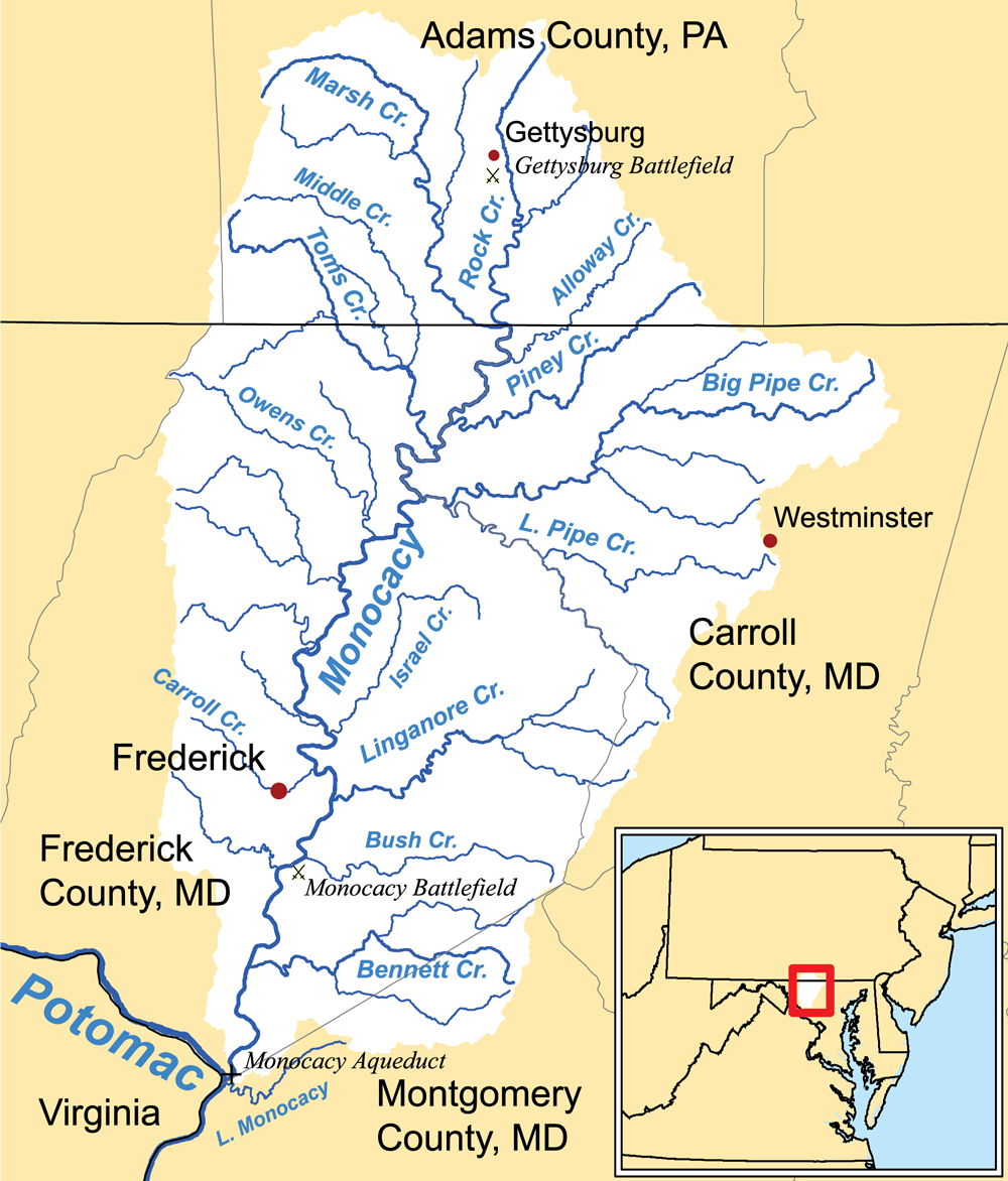
Marsh Creek is a U.S. Geological Survey. National Hydrography Dataset high-resolution flowline dataThe National Map, accessed August 15, 2011 tributary of the Monocacy River in south-central Pennsylvania and north-central Maryland in the United States.Gertler, Edward. ''Keystone Canoeing'', Seneca Press, 2004. Marsh Creek and Rock Creek join below Gettysburg and the Gettysburg Battlefield to form the Monocacy River. The height of land between Marsh and Rock creeks is the site of the Battle of Gettysburg. See also *List of rivers of Maryland *List of rivers of Pennsylvania This is a list of streams and rivers in the U.S. state of Pennsylvania. By drainage basin This list is arranged by drainage basin, with respective tributaries indented under each larger stream's name. Delaware Bay Chesapeake Bay *''E ... References External linksU.S. Geological Survey: PA stream gaging stations Rivers of Maryland Rivers of Pennsylvania Rivers of Frederick County, M ... [...More Info...] [...Related Items...] OR: [Wikipedia] [Google] [Baidu] |


