|
The Trundle
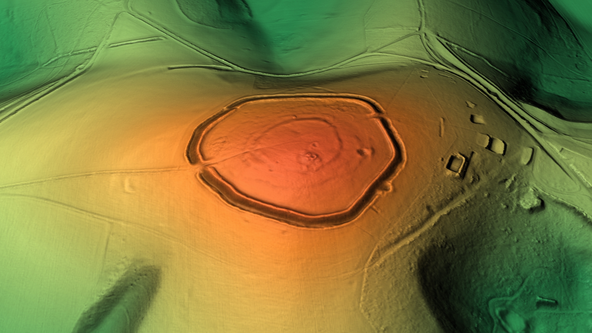
The Trundle is an Iron Age hillfort on St Roche's Hill about north of Chichester, West Sussex, England, built on the site of a causewayed enclosure, a form of early Neolithic Earthworks (archaeology), earthwork found in northwestern Europe. Causewayed enclosures were built in England from shortly before 3700 BC until at least 3500 BC; they are characterized by the full or partial enclosure of an area with ditches that are interrupted by gaps, or causeways. Their purpose is not known; they may have been settlements, meeting places, or ritual sites. Hillforts were built as early as 1000 BC, in the Late Bronze Age Britain, Bronze Age, and continued to be built through the Iron Age until shortly before the Roman Britain, Roman occupation. A chapel dedicated to Saint Roch, St Roche was built on the hill around the end of the 14th century; it was in ruins by 1570. A windmill and a beacon were subsequently built on the hill. The site was occasionally used as a meeting place in t ... [...More Info...] [...Related Items...] OR: [Wikipedia] [Google] [Baidu] |
West Sussex
West Sussex is a county in South East England on the English Channel coast. The ceremonial county comprises the shire districts of Adur, Arun, Chichester, Horsham, and Mid Sussex, and the boroughs of Crawley and Worthing. Covering an area of 1,991 square kilometres (769 sq mi), West Sussex borders Hampshire to the west, Surrey to the north, and East Sussex to the east. The county town and only city in West Sussex is Chichester, located in the south-west of the county. This was legally formalised with the establishment of West Sussex County Council in 1889 but within the ceremonial County of Sussex. After the reorganisation of local government in 1974, the ceremonial function of the historic county of Sussex was divided into two separate counties, West Sussex and East Sussex. The existing East and West Sussex councils took control respectively, with Mid Sussex and parts of Crawley being transferred to the West Sussex administration from East Sussex. In the 2011 censu ... [...More Info...] [...Related Items...] OR: [Wikipedia] [Google] [Baidu] |
Crickley Hill
Crickley Hill and Barrow Wake ( & ) is a biological and geological Site of Special Scientific Interest in Gloucestershire, notified in 1974. The site (two parts) lies within the Cotswold Area of Outstanding Natural Beauty. It was formerly known as Crickley Hill and includes some of a site known as Tuffleys Quarry. Part of the site is owned and managed by Gloucestershire County Council and the National Trust as a Country Park. The Cotswold Way National Trail passes through Crickley Hill and Barrow Wake. Barrow Wake and Tuffley's Quarry are listed in the 'Cotswold District' Local Plan 2001–2011 (on line) as Key Wildlife Sites. Crickley Hill is listed in the 'Cotswold District' Local Plan 2001–2011 (on line) as an SSSI and Regionally Important Geological Site. Location The site lies south of Cheltenham on the Cotswold scarp and it supports a range of habitats characteristic of the Cotswold limestone. It includes species-rich grassland, semi-natural woodland, scrub and part ... [...More Info...] [...Related Items...] OR: [Wikipedia] [Google] [Baidu] |
Whitehawk Camp
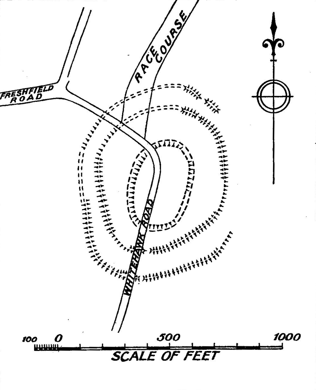
Whitehawk Camp is the remains of a causewayed enclosure on Whitehawk Hill near Brighton and Hove, Brighton, East Sussex, England. Causewayed enclosures are a form of Neolithic British Isles#Early and Middle Neolithic: 4000–2900 BCE, early Neolithic Earthworks (archaeology), earthwork that were built in England from shortly before 3700 BC until at least 3500 BC, characterized by the full or partial enclosure of an area with ditches that are interrupted by gaps, or causeways. Their purpose is not known; they may have been settlements, or meeting places, or ritual sites. The Whitehawk site consists of four roughly concentric circular ditches, with banks of earth along the interior of the ditches evident in some places. There may have been a timber palisade on top of the banks. Outside the outermost circuit there are at least two more ditches, one of which is thought from radiocarbon dating, radiocarbon evidence to date to the Bronze Age Britain, Bronze Age, about two thousand years a ... [...More Info...] [...Related Items...] OR: [Wikipedia] [Google] [Baidu] |
Cropmark
Cropmarks or crop marks are a means through which sub-surface archaeological, natural and recent features may be visible from the air or a vantage point on higher ground or a temporary platform. Such marks, along with parch marks, soil marks and frost marks, can reveal buried archaeological sites that are not visible from the ground. Description Crop marks are due to the principle of differential growth. One of the factors controlling the growth of vegetation is the condition of the soil. A buried stone wall, for example, will affect crop growth above it, as its presence channels water away from its area and occupies the space of the more fertile soil. Conversely, a buried ditch, with a fill containing more organic matter than the natural earth, provides much more conducive conditions and water will naturally collect there, nourishing the plants growing above. The differences in conditions will cause some plants to grow more strongly and therefore taller, and others less str ... [...More Info...] [...Related Items...] OR: [Wikipedia] [Google] [Baidu] |
Triangulation Station
A triangulation station, also known as a trigonometrical point, and sometimes informally as a trig, is a fixed surveying station, used in geodetic surveying and other surveying projects in its vicinity. The nomenclature varies regionally: they are generally known as trigonometrical stations or triangulation stations in North America, trig points in the United Kingdom, trig pillars in Ireland, trig stations or trig points in Australia and New Zealand, and trig beacons in South Africa. Use The station is usually set up by a government with known coordinates and elevation published. Many stations are located on hilltops for the purposes of visibility. A graven metal plate on the top of a pillar may provide a mounting point for a theodolite or reflector, often using some form of kinematic coupling to ensure reproducible positioning. Trigonometrical stations are grouped together to form a network of triangulation. Positions of all land boundaries, roads, railways, bridges and other ... [...More Info...] [...Related Items...] OR: [Wikipedia] [Google] [Baidu] |
Ordnance Survey
, nativename_a = , nativename_r = , logo = Ordnance Survey 2015 Logo.svg , logo_width = 240px , logo_caption = , seal = , seal_width = , seal_caption = , picture = , picture_width = , picture_caption = , formed = , preceding1 = , dissolved = , superseding = , jurisdiction = Great BritainThe Ordnance Survey deals only with maps of Great Britain, and, to an extent, the Isle of Man, but not Northern Ireland, which has its own, separate government agency, the Ordnance Survey of Northern Ireland. , headquarters = Southampton, England, UK , region_code = GB , coordinates = , employees = 1,244 , budget = , minister1_name = , minister1_pfo = , chief1_name = Steve Blair , chief1_position = CEO , agency_type = , parent_agency = , child1_agency = , keydocument1 = , website = , footnotes = , map = , map_width = , map_caption = Ordnance Survey (OS) is the national mapping agency for Great Britain. The agency's name indicates its original military purpose (se ... [...More Info...] [...Related Items...] OR: [Wikipedia] [Google] [Baidu] |
Goodwood Racecourse
Goodwood Racecourse is a horse-racing track five miles north of Chichester, West Sussex, in England controlled by the family of the Duke of Richmond, whose seat is nearby Goodwood House. It hosts the annual Glorious Goodwood meeting in late July and early August, which is one of the highlights of the British flat racing calendar, and is home to three of the UK's 36 annual Group 1 flat races, the Sussex Stakes, the Goodwood Cup and the Nassau Stakes. Although the race meeting has become known as 'Glorious Goodwood', it is sponsored by Qatar and officially called the 'Qatar Goodwood Festival'. It is considered to enjoy an attractive setting to the north of Trundle Iron Age hill fort, which is used as an informal grandstand with views of the whole course. One problem is that its proximity to the coast means that it can get foggy. This is an unusual, complex racecourse with a straight six furlongs—the "Stewards' Cup Course"—which is uphill for the first furlong and mos ... [...More Info...] [...Related Items...] OR: [Wikipedia] [Google] [Baidu] |
Chalk Group
The Chalk Group (often just called the Chalk) is the lithostratigraphic unit (a certain number of rock strata) which contains the Upper Cretaceous limestone succession in southern and eastern England. The same or similar rock sequences occur across the wider northwest European chalk 'province'. It is characterised by thick deposits of chalk, a soft porous white limestone, deposited in a marine environment. Chalk is a limestone that consists of coccolith biomicrite. A biomicrite is a limestone composed of fossil debris ("bio") and calcium carbonate mud ("micrite"). Most of the fossil debris in chalk consists of the microscopic plates, which are called coccoliths, of microscopic green algae known as coccolithophores. In addition to the coccoliths, the fossil debris includes a variable, but minor, percentage of the fragments of foraminifera, ostracods and mollusks. The coccolithophores lived in the upper part of the water column. When they died, the microscopic calcium carbonate p ... [...More Info...] [...Related Items...] OR: [Wikipedia] [Google] [Baidu] |
The Trundle Aerial Photo 1925
''The'' () is a grammatical Article (grammar), article in English language, English, denoting persons or things that are already or about to be mentioned, under discussion, implied or otherwise presumed familiar to listeners, readers, or speakers. It is the definite article in English. ''The'' is the Most common words in English, most frequently used word in the English language; studies and analyses of texts have found it to account for seven percent of all printed English-language words. It is derived from gendered articles in Old English which combined in Middle English and now has a single form used with nouns of any gender. The word can be used with both singular and plural nouns, and with a noun that starts with any letter. This is different from many other languages, which have different forms of the definite article for different genders or numbers. Pronunciation In most dialects, "the" is pronounced as (with the voiced dental fricative followed by a schwa) when fol ... [...More Info...] [...Related Items...] OR: [Wikipedia] [Google] [Baidu] |

.png)


.png)