|
The Battery (Manhattan)
The Battery, formerly known as Battery Park, is a public park located at the southern tip of Manhattan#Manhattan Island, Manhattan Island in New York City facing New York Harbor. It is bounded by Battery Place on the north, State Street (Manhattan), State Street on the east, New York Harbor to the south, and the Hudson River to the west. The park contains attractions such as an early 19th-century fort named Castle Clinton; multiple monuments; and the SeaGlass Carousel. The surrounding area, known as South Ferry (Manhattan), South Ferry, contains multiple ferry terminals, including the Staten Island Ferry's Whitehall Terminal; a boat launch to the Statue of Liberty National Monument (which includes Ellis Island and Liberty Island); and a boat launch to Governors Island. The park and surrounding area is named for the artillery battery, artillery batteries that were built in the late 17th century to protect the settlement behind them. By the 1820s, the Battery had become an entert ... [...More Info...] [...Related Items...] OR: [Wikipedia] [Google] [Baidu] |
City Pier A
Pier A (also known as City Pier A) is a pier in the Hudson River at Battery Park in Lower Manhattan, New York City. It was built from 1884 to 1886 as the headquarters of the New York City Board of Dock Commissioners and the New York City Police Department (NYPD)'s Harbor Department. Pier A is the only remaining masonry pier in New York City. Above the pier is a two- and three-story building designed by George Sears Greene Jr., with a clock tower facing the Hudson River. The pier is a New York City designated landmark and is listed on the National Register of Historic Places (NRHP). The building atop Pier A is generally two to three stories tall, except for a four-story clock tower at the southwestern corner of the building. The original structure is two stories tall and extends west into the Hudson River. The eastern, or inshore, end of Pier A was constructed in 1900 and expanded to three stories in 1904. The pier itself is composed of a concrete deck supported by girders. The ... [...More Info...] [...Related Items...] OR: [Wikipedia] [Google] [Baidu] |
Staten Island Ferry
The Staten Island Ferry is a passenger ferry route operated by the New York City Department of Transportation. The ferry's single route runs through New York Harbor between the New York City boroughs of Manhattan and Staten Island, with ferry boats making the trip in about 25 minutes. The ferry operates 24 hours a day, 7 days a week, with boats leaving every 15 to 20 minutes during peak hours and every 30 minutes at other times. It is the only direct mass-transit connection between the two boroughs. Historically, the Staten Island Ferry has charged a relatively low fare compared to other modes of transit in the area; and since 1997, the route has been fare-free. The Staten Island Ferry is one of several ferry systems in the New York City area and is operated separately from systems such as NYC Ferry and NY Waterway. The Staten Island Ferry route terminates at Whitehall Terminal, on Whitehall Street in Lower Manhattan, and at St. George Terminal, in St. George, Staten Island. At ... [...More Info...] [...Related Items...] OR: [Wikipedia] [Google] [Baidu] |
Schreierstoren
The Schreierstoren (English language, English incorrectly translated as: Weeper's Tower), originally part of the Walls of Amsterdam, medieval city wall of Amsterdam, the Netherlands, was built in the 15th century. It was the location from which Henry Hudson set sail on his journey to Northern America. This expedition would lead to the discovery of the island of Manhattan, among others. It was built as a fortification, defense tower in 1487. It is currently a café and nautical bookstore. The old name was 'Schreyhoeckstoren' meaning in old Dutch the sharp angle of the tower with the once-connected city walls. Later the name began to be shortened to the Schreierstoren. Schreierstoren is known mainly for the fact that women wept there for their husbands, who would leave from that port, to go to war, or to fish. (Most of the weeping that was done was for the fishermen who left from that port.) While many in history have called this (the weeping, that is) a myth, there is one thing ... [...More Info...] [...Related Items...] OR: [Wikipedia] [Google] [Baidu] |
Broadway (Manhattan)
Broadway () is a road in the U.S. state of New York (state), New York. Broadway runs from State Street (Manhattan), State Street at Bowling Green (New York City), Bowling Green for through the Boroughs of New York City, borough of Manhattan and through the Bronx, exiting north from New York City to run an additional through the Westchester County, New York, Westchester County municipalities of Yonkers, New York, Yonkers, Hastings-on-Hudson, New York, Hastings-On-Hudson, Dobbs Ferry, New York, Dobbs Ferry, Irvington, New York, Irvington, and Tarrytown, New York, Tarrytown, and terminating north of Sleepy Hollow, New York, Sleepy Hollow.There are four other streets named "Broadway" in New York City's remaining three boroughs: one each in Brooklyn (Broadway (Brooklyn), see main article) and Staten Island, and two in Queens (one running from Astoria, Queens, Astoria to Elmhurst, Queens, Elmhurst, and the other in Hamilton Beach, Queens, Hamilton Beach). Each borough therefore has ... [...More Info...] [...Related Items...] OR: [Wikipedia] [Google] [Baidu] |
New Amsterdam
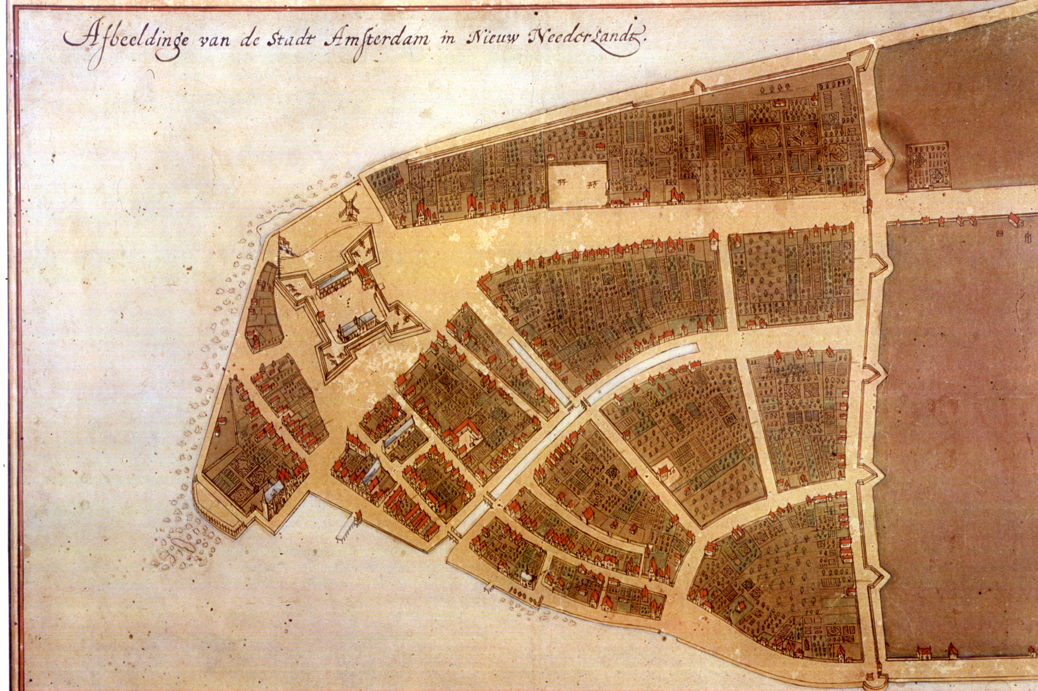
New Amsterdam ( nl, Nieuw Amsterdam, or ) was a 17th-century Dutch settlement established at the southern tip of Manhattan Island that served as the seat of the colonial government in New Netherland. The initial trading ''factory'' gave rise to the settlement around Fort Amsterdam. The fort was situated on the strategic southern tip of the island of Manhattan and was meant to defend the fur trade operations of the Dutch West India Company in the North River (Hudson River). In 1624, it became a provincial extension of the Dutch Republic and was designated as the capital of the province in 1625. By 1655, the population of New Netherland had grown to 2,000 people, with 1,500 living in New Amsterdam. By 1664, the population of New Netherland had risen to almost 9,000 people, 2,500 of whom lived in New Amsterdam, 1,000 lived near Fort Orange, and the remainder in other towns and villages. In 1664, the English took over New Amsterdam and renamed it New York after the Duke of ... [...More Info...] [...Related Items...] OR: [Wikipedia] [Google] [Baidu] |
Lenape
The Lenape (, , or Lenape , del, Lënapeyok) also called the Leni Lenape, Lenni Lenape and Delaware people, are an indigenous peoples of the Northeastern Woodlands, who live in the United States and Canada. Their historical territory included present-day northeastern Delaware, New Jersey and eastern Pennsylvania along the Delaware River watershed, New York City, western Long Island, and the lower Hudson Valley. Today, Lenape people belong to the Delaware Nation and Delaware Tribe of Indians in Oklahoma; the Stockbridge–Munsee Community in Wisconsin; and the Munsee-Delaware Nation, Moravian of the Thames First Nation, and Delaware of Six Nations in Ontario. The Lenape have a matrilineal clan system and historically were matrilocal. During the last decades of the 18th century, most Lenape were removed from their homeland by expanding European colonies. The divisions and troubles of the American Revolutionary War and United States' independence pushed them farther west. ... [...More Info...] [...Related Items...] OR: [Wikipedia] [Google] [Baidu] |
Battery Park Underpass
The Battery Park Underpass is a vehicular tunnel at the southernmost tip of Manhattan, New York City, near the neighborhoods of South Ferry and Battery Park City. The tunnel connects FDR Drive, which runs along the east side of Manhattan Island, with the West Side Highway (New York State Route 9A, or NY 9A), which runs along the island's west side. Opened in 1951, it was the second section of the FDR Drive to be completed. The underpass crosses beneath the Battery (formerly Battery Park) and the approach to the Brooklyn–Battery Tunnel. History The underpass started construction in 1949 and opened to the public on April 10, 1951. The underpass runs underneath the Battery, connecting the West Side Highway to the South Street Viaduct with two lanes of traffic in each direction. The project was completed shortly after the opening of the Brooklyn-Battery Tunnel in 1950, and provides direct access between the West Side Highway and FDR Drive. In 2005, during the reconstruc ... [...More Info...] [...Related Items...] OR: [Wikipedia] [Google] [Baidu] |
Brooklyn–Battery Tunnel
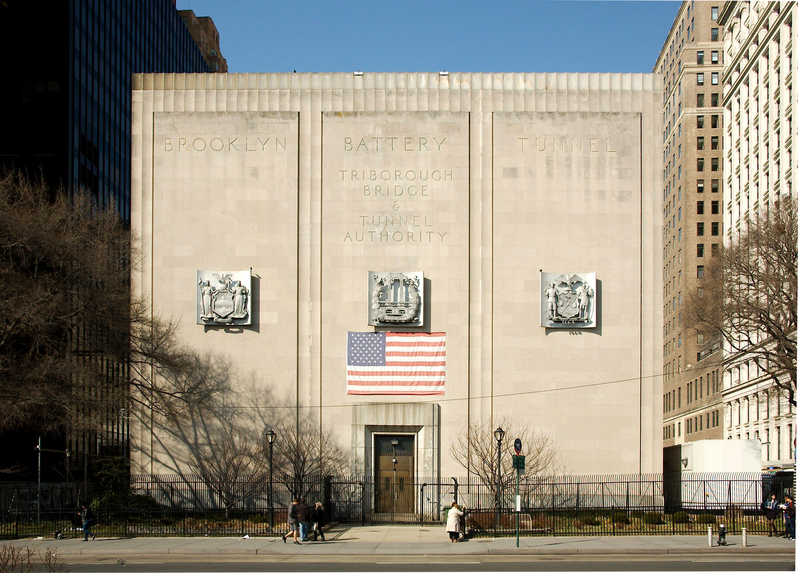
The Brooklyn–Battery Tunnel, officially the Hugh L. Carey Tunnel and commonly referred to as the Battery Tunnel or Battery Park Tunnel, is a tolled tunnel in New York City that connects Red Hook in Brooklyn with the Battery in Manhattan. The tunnel consists of twin tubes that each carry two traffic lanes under the mouth of the East River. Although it passes just offshore of Governors Island, the tunnel does not provide vehicular access to the island. With a length of , it is the longest continuous underwater vehicular tunnel in North America. Plans for the Brooklyn–Battery Tunnel date back to the 1920s. Official plans to build the tunnel were submitted in 1930 but were initially not carried out. The New York City Tunnel Authority, created in 1936, was tasked with constructing the tunnel. After unsuccessful attempts to secure federal funds, New York City Parks Commissioner Robert Moses proposed a Brooklyn–Battery Bridge. However, the public opposed the bridge plan, an ... [...More Info...] [...Related Items...] OR: [Wikipedia] [Google] [Baidu] |
New York Aquarium
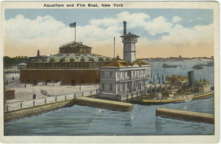
The New York Aquarium is the oldest continually operating aquarium in the United States, located on the Riegelmann Boardwalk in Coney Island, Brooklyn, New York City. It was founded at Castle Garden in Battery Park, Manhattan in 1896, and moved to Coney Island in 1957. The aquarium is operated by the Wildlife Conservation Society (WCS) as part of its integrated system of four zoos and one aquarium, most notably the Bronx Zoo. It is accredited by the Association of Zoos and Aquariums (AZA). As part of WCS, the aquarium's mission is to save wildlife and wild places worldwide through science, conservation action, education, and inspiring people to value nature. The facility occupies and boasts 266 species of aquatic wildlife. Its mission is to raise public awareness about issues facing the ocean and its inhabitants with special exhibits, public events and research. The New York Seascape program, based out of the aquarium, is WCS's local conservation program designed to restore heal ... [...More Info...] [...Related Items...] OR: [Wikipedia] [Google] [Baidu] |
Artillery Battery
In military organizations, an artillery battery is a unit or multiple systems of artillery, mortar systems, rocket artillery, multiple rocket launchers, surface-to-surface missiles, ballistic missiles, cruise missiles, etc., so grouped to facilitate better battlefield communication and command and control, as well as to provide dispersion for its constituent gunnery crews and their systems. The term is also used in a naval context to describe groups of guns on warships. Land usage Historically the term "battery" referred to a cluster of cannon in action as a group, either in a temporary field position during a battle or at the siege of a fortress or a city. Such batteries could be a mixture of cannon, howitzer, or mortar types. A siege could involve many batteries at different sites around the besieged place. The term also came to be used for a group of cannon in a fixed fortification, for coastal or frontier defence. During the 18th century "battery" began to be used as a ... [...More Info...] [...Related Items...] OR: [Wikipedia] [Google] [Baidu] |
Governors Island
Governors Island is a island in New York Harbor, within the New York City borough of Manhattan. It is located approximately south of Manhattan Island, and is separated from Brooklyn to the east by the Buttermilk Channel. The National Park Service administers a small portion of the north end of the island as the Governors Island National Monument, including two former military fortifications named Fort Jay and Castle Williams. The Trust for Governors Island operates the remaining , including 52 historic buildings, as a public park. About of the land area is fill, added in the early 1900s to the south of the original island. The native Lenape originally referred to Governors Island as Paggank ("nut island") because of the area's rich collection of chestnut, hickory, and oak trees; it is believed that this space was originally used for seasonal foraging and hunting. The name was translated into the Dutch Noten Eylandt, then Anglicized into Nutten Island, before being rename ... [...More Info...] [...Related Items...] OR: [Wikipedia] [Google] [Baidu] |
Liberty Island
Liberty Island is a federally owned island in Upper New York Bay in the United States. Its most notable feature is the Statue of Liberty (''Liberty Enlightening the World''), a large statue by Frédéric Auguste Bartholdi that was dedicated in 1886. The island also contains the Statue of Liberty Museum, which opened in 2019 and exhibits the statue's original torch. Long known as Bedloe's Island, it was renamed by an act of the United States Congress in 1956. Part of New York (state), New York State, the island is an exclave of the New York City Boroughs of New York City, borough of Manhattan, surrounded by the waters of Jersey City, New Jersey. Liberty Island became part of the Statue of Liberty National Monument in 1937 through Presidential Proclamation 2250, signed by President Franklin D. Roosevelt. In 1966, it was listed on the National Register of Historic Places as part of Statue of Liberty National Monument, Statue of Liberty National Monument, Ellis Island and Liberty I ... [...More Info...] [...Related Items...] OR: [Wikipedia] [Google] [Baidu] |


.jpg)


.jpg)
