|
Temple Ring
A temple ring is an ornament that hangs from a headdress or in braids of hair in the front area at the side of the head i.e. near a person's anatomical temple. Temple rings were part of Slavic, Scandinavian and others' medieval women's dress. Most were made of base metals such as copper alloys or iron, though silver and even gold were occasionally used. These were known as temple rings because they were worn on the head, near the temples of a woman or a girl. Slavic temple rings Temple rings were characteristic decorations of Slavic women. Different tribes had their own designs and they were made out of various metals. The rings were attached to a string that became part of a headdress or they were woven directly into braids of hair. The earliest archeological evidence of temple rings was found in the Catacomb culture, Unetice culture and Karasuk culture. Later they were also found in the Chernoles culture. Temple rings were most popular between the 8th and 12th centuries, pos ... [...More Info...] [...Related Items...] OR: [Wikipedia] [Google] [Baidu] |
Radimichs
The Radimichs (also Radimichi) ( be, Радзiмiчы, russian: Радимичи, uk, Радимичі and pl, Radymicze) were an East Slavic tribe of the last several centuries of the 1st millennium, which inhabited upper east parts of the Dnipro down the Sozh and its tributaries. The name probably derives from the name of the forefather of the tribe - Radim. According to Ruthenian chronicle tradition, "... but there were Radimichs from the Lechites family, who came and settled here and paid tribute to Rus, and the wagon was carried to the present day" (a ''wagon'' is a type of tax for the right to have one's own prince). However, in the scientific literature, there is no consensus on the ethnicity of the Radimichs. Archaeological evidence indicates that this tribal association had a mixed Slavic-Baltic origin. The Radimichs lived in the interfluve of the upper Dnipro and Desna rivers along the Sozh and its tributaries (the south of Vitebsk, the east of the Mogilev and Gome ... [...More Info...] [...Related Items...] OR: [Wikipedia] [Google] [Baidu] |
Shield
A shield is a piece of personal armour held in the hand, which may or may not be strapped to the wrist or forearm. Shields are used to intercept specific attacks, whether from close-ranged weaponry or projectiles such as arrows, by means of active blocks, as well as to provide passive protection by closing one or more lines of engagement during combat. Shields vary greatly in size and shape, ranging from large panels that protect the user's whole body to small models (such as the buckler) that were intended for hand-to-hand-combat use. Shields also vary a great deal in thickness; whereas some shields were made of relatively deep, absorbent, wooden planking to protect soldiers from the impact of spears and crossbow bolts, others were thinner and lighter and designed mainly for deflecting blade strikes (like the roromaraugi or qauata). Finally, shields vary greatly in shape, ranging in roundness to angularity, proportional length and width, symmetry and edge pattern; different s ... [...More Info...] [...Related Items...] OR: [Wikipedia] [Google] [Baidu] |
Novgorod Slovenes Temple Rings GIM
Veliky Novgorod ( rus, links=no, Великий Новгород, t=Great Newtown, p=vʲɪˈlʲikʲɪj ˈnovɡərət), also known as just Novgorod (), is the largest city and administrative centre of Novgorod Oblast, Russia. It is one of the oldest cities in Russia, being first mentioned in the 9th century. The city lies along the Volkhov River just downstream from its outflow from Lake Ilmen and is situated on the M10 federal highway connecting Moscow and Saint Petersburg. UNESCO recognized Novgorod as a World Heritage Site in 1992. The city has a population of At its peak during the 14th century, the city was the capital of the Novgorod Republic and was one of Europe's largest cities. The "Veliky" ("great") part was added to the city's name in 1999. History Early developments The Sofia First Chronicle makes initial mention of it in 859, while the Novgorod First Chronicle first mentions it in 862, when it was purportedly already a major Baltics-to-Byzantium station on the ... [...More Info...] [...Related Items...] OR: [Wikipedia] [Google] [Baidu] |
Smolensk Oblast
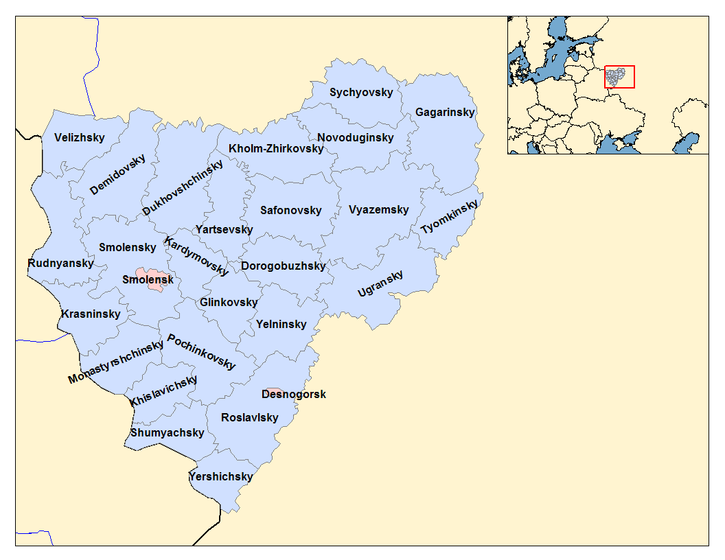
Smolensk Oblast (russian: Смоле́нская о́бласть, ''Smolenskaya oblast''; informal name — ''Smolenschina'' (russian: Смоле́нщина)) is a federal subject of Russia (an oblast). Its administrative centre is the city of Smolensk. As of the 2010 Census, its population was 985,537. Geography The oblast was founded on 27 September 1937.Исполнительный комитет Смоленского областного совета народных депутатов. Государственный архив Смоленской области. "Административно-территориальное устройство Смоленской области. Справочник", изд. "Московский рабочий", Москва 1981. Стр. 8 It borders Pskov Oblast in the north, Tver Oblast in the northeast, Moscow Oblast in the east, Kaluga Oblast in south, Bryansk Oblast in the southwest, and Mogilev and Vitebsk Oblast ... [...More Info...] [...Related Items...] OR: [Wikipedia] [Google] [Baidu] |
Ryazan Oblast
Ryazan Oblast ( rus, Рязанская область, r=Ryazanskaya oblast, p=rʲɪˈzanskəjə ˈobləsʲtʲ) is a federal subjects of Russia, federal subject of Russia (an oblast). Its administrative center is the types of inhabited localities in Russia, city of Ryazan, which is the oblast's largest city. Geography Ryazan Oblast borders Vladimir Oblast (N), Nizhny Novgorod Oblast (NE), the Republic of Mordovia (E), Penza Oblast (SE), Tambov Oblast (S), Lipetsk Oblast (SW), Tula Oblast (W), and Moscow Oblast (NW). In terms of physical geography, Ryazan Oblast lies in the central part of the Russian Plain between the Central Russian Upland, Central Russian and Volga Upland, Volga uplands. The terrain is flat, with the highest point of no more than 300 m above sea level. Soils are podzolic and boggy on the left bank of the Oka River, Oka, changing southward to more fertile podzolic and leached black-earths (chernozem, chernozyom). Hydrography Most of the Ryazan Oblast lies wi ... [...More Info...] [...Related Items...] OR: [Wikipedia] [Google] [Baidu] |
Nizhny Novgorod Oblast
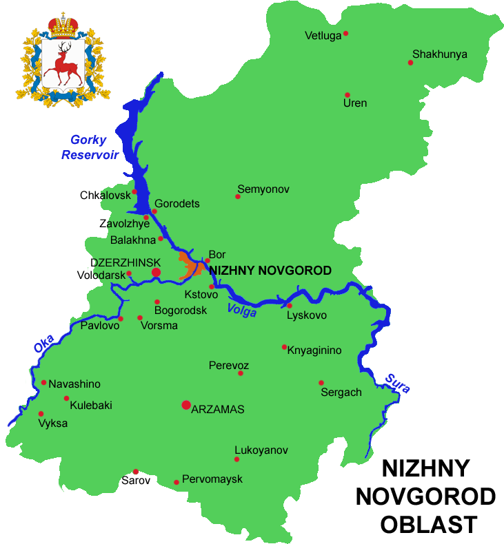
Nizhny Novgorod Oblast (russian: link=no, Нижегородская область, ''Nizhegorodskaya oblast''), is a federal subjects of Russia, federal subject of Russia (an oblast). Its administrative center is the types of inhabited localities in Russia, city of Nizhny Novgorod. It has a population of 3,310,597 as of the Russian Census (2010), 2010 Census. From 1932 to 1990 it was known as Gorky Oblast. The oblast is crossed by the Volga River. Apart from Nizhny Novgorod's metropolitan area (including Dzerzhinsk, Russia, Dzerzhinsk, Bor, Nizhny Novgorod Oblast, Bor and Kstovo) the biggest city is Arzamas. Near the town of Sarov there is the Serafimo-Diveyevsky Monastery, one of the largest convents in Russia, established by Seraphim of Sarov, Saint Seraphim of Sarov. The Makaryev Monastery opposite of the town of Lyskovo, Nizhny Novgorod Oblast, Lyskovo used to be the location of the largest fair in Eastern Europe. Other historic towns include Gorodets, Nizhny Novgorod Oblast ... [...More Info...] [...Related Items...] OR: [Wikipedia] [Google] [Baidu] |
Kaluga Oblast
Kaluga Oblast (russian: Калу́жская о́бласть, translit=Kaluzhskaya oblast) is a federal subject of Russia (an oblast). Its administrative center is the city of Kaluga. The 2021 Russian Census found a population of 1,069,904. Geography Kaluga Oblast lies in the central part of the East European Plain. The oblast's territory is located between the Central Russian Upland (with and average elevation of above and a maximum elevation of in the southeast), the Smolensk–Moscow Upland and the Dnieper– Desna watershed. Most of the oblast is occupied by plains, fields and forests with diverse flora and fauna. The administrative center is located on the Baryatino-Sukhinichy plain. The western part of the oblast — located within the drift plain — is dominated by the Spas-Demensk ridge. To the south is an outwash plain that is part of the Bryansk-Zhizdra woodlands, with average elevation up to 200 m. From north to south, Kaluga Oblast extends for more th ... [...More Info...] [...Related Items...] OR: [Wikipedia] [Google] [Baidu] |
Pskov Oblast
Pskov Oblast (russian: Пско́вская о́бласть, ') is a federal subjects of Russia, federal subject of Russia (an oblast), located in the west of the country. Its administrative center is the types of inhabited localities in Russia, city of Pskov. As of the Russian Census (2010), 2010 Census, its population was 673,423. Geography Pskov Oblast is the westernmost federal subjects of Russia, federal subject of contiguous Russia (Kaliningrad Oblast, while located further to the west, is an enclave and exclave, exclave).1september.ru. Д. В. Заяц (D. V. Zayats).Псковская область (''Pskov Oblast''). It borders with Leningrad Oblast in the north, Novgorod Oblast in the east, Tver Oblast, Tver and Smolensk Oblasts in the southeast, Vitebsk Region, Vitebsk Oblast of Belarus in the south, and with the counties of Latvia (Alūksne Municipality, Balvi Municipality, and Ludza Municipality) and Estonia (Võru County) in the west. In the northwest, Pskov O ... [...More Info...] [...Related Items...] OR: [Wikipedia] [Google] [Baidu] |
Minsk Region
Minsk Region or Minsk Oblast or Minsk Voblasts ( be, Мі́нская во́бласць, ''Minskaja voblasć'' ; russian: Минская о́бласть, ''Minskaya oblast'') is one of the regions of Belarus. Its administrative center is Minsk, although it is a separate administrative territorial entity of Belarus. As of 2011, the region's population is 1,411,500. Geography Minsk Region covers a total of 39,900 km², about 19.44% of the national total area. Lake Narach, the largest lake in the country, is located in the northern part of the region. There are four other large lakes in this region: Svir (8th largest), Myadel (11th largest), Syalyava (14th largest) and Myastro (15th largest). It is the only region of Belarus whose border is not part of the international border of Belarus. History Beginning the 10th century, the territory of the current Minsk Region was part of Kievan Rus', the Principality of Polotsk, and later it was included in the Grand Duchy of Lithua ... [...More Info...] [...Related Items...] OR: [Wikipedia] [Google] [Baidu] |
Vitebsk Region
Vitebsk Region or Vitebsk Oblast or Viciebsk Voblasts ( be, Ві́цебская во́бласць, ''Viciebskaja voblasć'', ; rus, Ви́тебская о́бласть, Vitebskaya oblast, ˈvʲitʲɪpskəjə ˈobləsʲtʲ) is a region (oblast) of Belarus with its administrative center being Vitebsk. It is located near the border with Russia. As of a 2019, the region had a population of 1,135,731. It has the lowest population density in Belarus at 30.6 p/km². Important cities within the region include Vitebsk, Orsha, Polotsk, and Novopolotsk. Geography Vitebsk Region covers an area of 40,000 km², which is about 19.4% of the national total. It is bordered on the north by Pskov Oblast of Russia, by Smolensk Oblast of Russia on the east, on the south by Minsk Region and by Mogilev Region, on the southwest by Minsk Region and Grodno Region, and on the west and northwest by Vilnius and Utena counties of Lithuania and Augšdaugava, Krāslava and Ludzamunicipalities of Latv ... [...More Info...] [...Related Items...] OR: [Wikipedia] [Google] [Baidu] |
Bangle
Bangles are traditionally rigid bracelets which are usually made of metal, wood, glass or plastic. These ornament are worn mostly by women in the Indian subcontinent, Southeastern Asia, Arabian Peninsula, and Africa. It is common to see a bride wearing glass bangles at weddings in India, Bangladesh, Pakistan, Nepal, Sri Lanka and in other Asian countries. Bangles may also be worn by young girls and bangles made of gold or silver are preferred for toddlers. Some men and women wear a single bangle on the arm or wrist called ''kada'' or ''kara''. In Sikhism, the father of a Sikh bride will give the groom a gold ring, a kara (steel or iron bangle), and a mohra. Chooda is a kind of bangle that is worn by Punjabi women on her wedding day. It is a set of white and red bangles with stonework. According to tradition, a woman is not supposed to buy the bangles she will wear. Firozabad, Uttar Pradesh is India's largest producer of bangles. History Bangles made from sea shell, copper, b ... [...More Info...] [...Related Items...] OR: [Wikipedia] [Google] [Baidu] |
.png)
.jpg)


