|
Tawang Chhu
Tawang Chu is the main river of the Tawang district in Arunachal Pradesh, India. The entire district may be regarded as the basin of the Tawang Chu river. In addition, two south-flowing rivers from Tibet, viz., Tsona Chu and Nyamjang Chu, join the river within the district. The combined river flows west into Bhutan, where it progresses to the Manas River and flows into the Assam state of India. Tawang Chu is formed by the joining of three rivers originating within the Tawang district: Goshu Chu, Dungma Chu and Gorjo Chu. These rivers merge near the village of Mago (), after which the combined river is called Mago Chu. After Tsona Chu joins it, near Kyelatongbo at an elevation of , the combined river is called Tawang Chu. The river flows west towards Bhutan, passing by the Tawang town on its southern flank. Near Lumla, the Nyamjang Chu river originating in Tibet joins Tawang Chu. The river enters Bhutan after passing the Dudunghar Circle of the Tawang district. At Duksum, the r ... [...More Info...] [...Related Items...] OR: [Wikipedia] [Google] [Baidu] |
Tawang District
Tawang district (Pron:/tɑ:ˈwæŋ or təˈwæŋ/) is the smallest of the 26 administrative districts of Arunachal Pradesh state in northeastern India. With a population of 49,977, it is the eighth least populous district in the country (out of 707). History Tawang is inhabited by the Monpa people. From 500 BC to 600 AD a kingdom known as Lhomon or Monyul ruled the area. The Monyul kingdom was later absorbed into the control of neighbouring Bhutan and Tibet. Tawang Monastery was founded by the Merak Lama Lodre Gyatso in 1681 in accordance with the wishes of the 5th Dalai Lama, Ngawang Lobsang Gyatso, and has an interesting legend surrounding its name, which means "Chosen by Horse". The sixth Dalai Lama, Tsangyang Gyatso, was born in Tawang. Tawang was historically part of Tibet. The 1914 Simla Accord defined the McMahon Line as the new boundary between British India and Tibet. By this treaty, Tibet relinquished several hundred square miles of its territory, including Ta ... [...More Info...] [...Related Items...] OR: [Wikipedia] [Google] [Baidu] |
Rivers Of Bhutan
A river is a natural flowing watercourse, usually freshwater, flowing towards an ocean, sea, lake or another river. In some cases, a river flows into the ground and becomes dry at the end of its course without reaching another body of water. Small rivers can be referred to using names such as creek, brook, rivulet, and rill. There are no official definitions for the generic term river as applied to geographic features, although in some countries or communities a stream is defined by its size. Many names for small rivers are specific to geographic location; examples are "run" in some parts of the United States, "burn" in Scotland and northeast England, and "beck" in northern England. Sometimes a river is defined as being larger than a creek, but not always: the language is vague. Rivers are part of the water cycle. Water generally collects in a river from precipitation through a drainage basin from surface runoff and other sources such as groundwater recharge, springs, a ... [...More Info...] [...Related Items...] OR: [Wikipedia] [Google] [Baidu] |
Rivers Of Arunachal Pradesh
A river is a natural flowing watercourse, usually freshwater, flowing towards an ocean, sea, lake or another river. In some cases, a river flows into the ground and becomes dry at the end of its course without reaching another body of water. Small rivers can be referred to using names such as creek, brook, rivulet, and rill. There are no official definitions for the generic term river as applied to geographic features, although in some countries or communities a stream is defined by its size. Many names for small rivers are specific to geographic location; examples are "run" in some parts of the United States, "burn" in Scotland and northeast England, and "beck" in northern England. Sometimes a river is defined as being larger than a creek, but not always: the language is vague. Rivers are part of the water cycle. Water generally collects in a river from precipitation through a drainage basin from surface runoff and other sources such as groundwater recharge, springs, a ... [...More Info...] [...Related Items...] OR: [Wikipedia] [Google] [Baidu] |
Tawang District With Labels
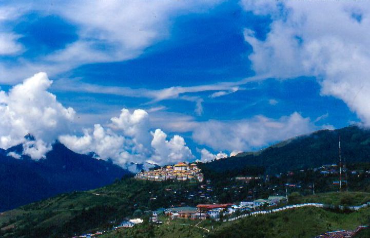
Tawang is a town and administrative headquarter of Tawang district in the Indian state of Arunachal Pradesh. The town was once the capital of the Tawang Tract, which is now divided into the Tawang district and the West Kameng district. Tawang continues as the headquarters of the former. Tawang is situated 448 km north-west of state capital Itanagar at an elevation of approximately . It lies to the north of the Tawang Chu river valley, roughly south of the Line of Actual Control with China. It is the site of a famous Gelugpa Buddhist Monastery. History Tawang is inhabited by the Monpa people. The Tawang Monastery was founded by the Merak Lama Lodre Gyatso in 1681 in accordance with the wishes of the 5th Dalai Lama, Ngawang Lobsang Gyatso, and has an interesting legend surrounding its name. ‘TA’ means 'Horse' and ‘WANG’ means 'Chosen'. So, the word 'Tawang' means "Chosen by Horse". As per a legend, the Monastery is believed to have been chosen by a Horse Owned b ... [...More Info...] [...Related Items...] OR: [Wikipedia] [Google] [Baidu] |
Tawang
Tawang is a town and administrative headquarter of Tawang district in the Indian state of Arunachal Pradesh. The town was once the capital of the Tawang Tract, which is now divided into the Tawang district and the West Kameng district. Tawang continues as the headquarters of the former. Tawang is situated 448 km north-west of state capital Itanagar at an elevation of approximately . It lies to the north of the Tawang Chu river valley, roughly south of the Line of Actual Control with China. It is the site of a famous Gelugpa Buddhist Monastery. History Tawang is inhabited by the Monpa people. The Tawang Monastery was founded by the Merak Lama Lodre Gyatso in 1681 in accordance with the wishes of the 5th Dalai Lama, Ngawang Lobsang Gyatso, and has an interesting legend surrounding its name. ‘TA’ means 'Horse' and ‘WANG’ means 'Chosen'. So, the word 'Tawang' means "Chosen by Horse". As per a legend, the Monastery is believed to have been chosen by a Horse Owned by ... [...More Info...] [...Related Items...] OR: [Wikipedia] [Google] [Baidu] |
Assam
Assam (; ) is a state in northeastern India, south of the eastern Himalayas along the Brahmaputra and Barak River valleys. Assam covers an area of . The state is bordered by Bhutan and Arunachal Pradesh to the north; Nagaland and Manipur to the east; Meghalaya, Tripura, Mizoram and Bangladesh to the south; and West Bengal to the west via the Siliguri Corridor, a wide strip of land that connects the state to the rest of India. Assamese and Boro are the official languages of Assam, while Bengali is an additional official language in the Barak Valley. Assam is known for Assam tea and Assam silk. The state was the first site for oil drilling in Asia. Assam is home to the one-horned Indian rhinoceros, along with the wild water buffalo, pygmy hog, tiger and various species of Asiatic birds, and provides one of the last wild habitats for the Asian elephant. The Assamese economy is aided by wildlife tourism to Kaziranga National Park and Manas National Park, which are ... [...More Info...] [...Related Items...] OR: [Wikipedia] [Google] [Baidu] |
Nyamjang Chu
Nyamjang Chu, or Nyashang Chu () is a cross-border perennial river that originates in the Shannan Prefecture of Tibet and flows into the Arunachal Pradesh state of India, joining the Tawang Chu river just before it enters Bhutan. The Nyamjang Chu valley has provided the traditional communication route between Tawang and Tibet. The valley near town of Zemithang in the Tawang district, called the Pangchen Valley, is known for its serene beauty and forms one of the wintering locations for the black-necked crane. The China–India border in the valley has been contested between the two countries since the 1950s, resulting in a clash at Namka Chu in 1962 and a standoff at Sumdorong Chu in 1986. Course The Nyamjang Chu river originates in the snow-clad peaks of the eastern Himalayas, north of Taga in the Chudromo township of the Tsona County, at an elevation of . Frederick Bailey and Henry Morshead, explored the region in 1913. They crossed into the valley of Nyamjang Chu from ... [...More Info...] [...Related Items...] OR: [Wikipedia] [Google] [Baidu] |
Brahmaputra
The Brahmaputra is a trans-boundary river which flows through Tibet, northeast India, and Bangladesh. It is also known as the Yarlung Tsangpo in Tibetan, the Siang/Dihang River in Arunachali, Luit in Assamese, and Jamuna River in Bangla. It is the 9th largest river in the world by discharge, and the 15th longest. With its origin in the Manasarovar Lake region, near Mount Kailash, on the northern side of the Himalayas in Burang County of Tibet where it is known as the Yarlung Tsangpo River, It flows along southern Tibet to break through the Himalayas in great gorges (including the Yarlung Tsangpo Grand Canyon) and into Arunachal Pradesh. It flows southwest through the Assam Valley as the Brahmaputra and south through Bangladesh as the Jamuna (not to be confused with the Yamuna of India). In the vast Ganges Delta, it merges with the Ganges, popularly known as the Padma in Bangladesh, and becomes the Meghna and ultimately empties into the Bay of Bengal. About long, the Bra ... [...More Info...] [...Related Items...] OR: [Wikipedia] [Google] [Baidu] |
Arunachal Pradesh
Arunachal Pradesh (, ) is a state in Northeastern India. It was formed from the erstwhile North-East Frontier Agency (NEFA) region, and became a state on 20 February 1987. It borders the states of Assam and Nagaland to the south. It shares international borders with Bhutan in the west, Myanmar in the east, and a disputed border with China in the north at the McMahon Line. Itanagar is the state capital of Arunachal Pradesh. Arunachal Pradesh is the largest of the Seven Sister States of Northeast India by area. Arunachal Pradesh shares a 1,129 km border with China's Tibet Autonomous Region. As of the 2011 Census of India, Arunachal Pradesh has a population of 1,382,611 and an area of . It is an ethnically diverse state, with predominantly Monpa people in the west, Tani people in the centre, Mishmi and Tai people in the east, and Naga people in the southeast of the state. About 26 major tribes and 100 sub-tribes live in the state. The main tribes of the state are Adi, Nyshi ... [...More Info...] [...Related Items...] OR: [Wikipedia] [Google] [Baidu] |


.jpg)