|
Talaimannar
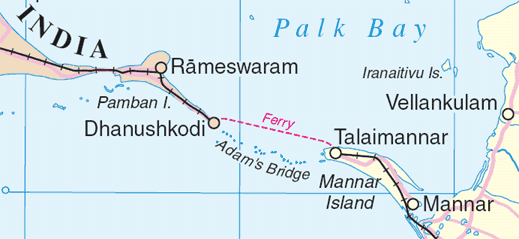
Talaimannar ( ta, தலைமன்னார்; si, තලෙයිමන්නාරම) is a settlement in Sri Lanka located on the northwestern coast of Mannar Island. Transport Sri Lanka's northern railway line was destroyed, disrupted or neglected during the 30-year Sri Lankan civil war, which ended in May 2009. The Mannar railway line, rebuilt by an Indian company, was reopened by Indian Prime Minister Narendra Modi in 2015. The pier is served by a station of the Sri Lanka Railways with railway terminus at Talaimannar which connects Talaimannar to rail network in Sri Lanka via Medawachchiya. The town can be reached by a road from Mannar which links the island to the rest of highway network in Sri Lanka through a causeway. Development Being a windy location, Talaimannar is a kitesurf and kiteboard destination. The government proposed a wind farm but was opposed by the local community as the area is a bird sanctuary. See also *Kachchatheevu *Palk Strait bridge *Ra ... [...More Info...] [...Related Items...] OR: [Wikipedia] [Google] [Baidu] |
Mannar Line
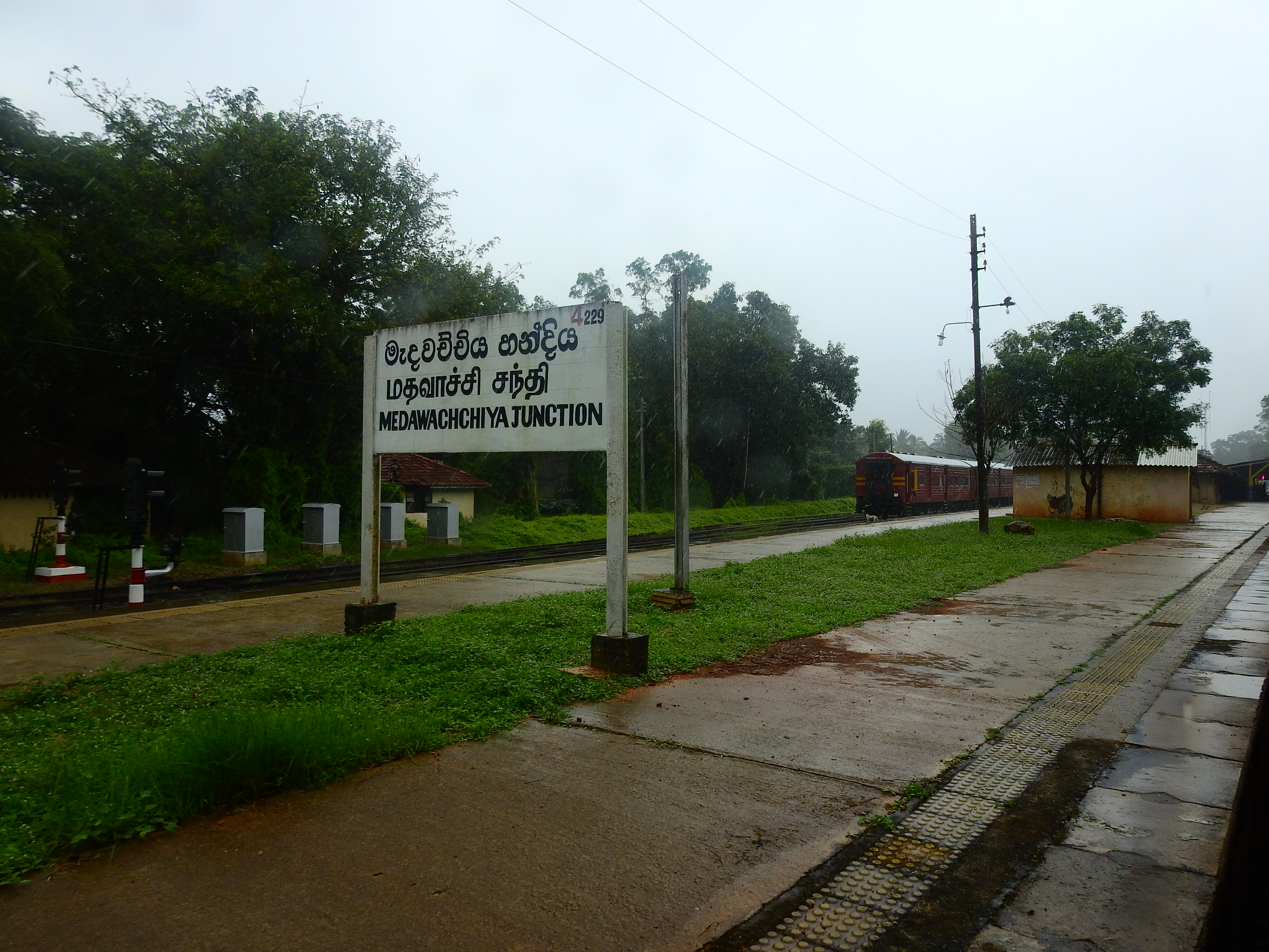
The Mannar line is a railway line in Sri Lanka. Branching off the northern line at Medawachchiya Junction, the line heads north-west through North Central and Northern provinces before terminating at the town of Talaimannar. The line is long and has 11 stations. The line opened in 1914. History International goal The Mannar line was built as part of a plan to create a rail link between Sri Lanka and India. A 22-mile bridge to link the two countries had been proposed as early as 1894, by the Consultant Engineer for railways in Madras (Chennai). The proposal was given serious consideration and a technical blueprint and cost analysis was conducted. By 1914, the Mannar line was built to connect Talaimannar on Mannar Island to the Sri Lankan mainland. On the Indian side, the Indian railway network was extended to Dhanushkodi. The international bridge to link the two was not built.http://infolanka.asia/sri-lanka/transport/the-indo-lanka-land-bridge-reviving-the-proposal The ... [...More Info...] [...Related Items...] OR: [Wikipedia] [Google] [Baidu] |
Sri Lanka Railways
The Sri Lanka Railway Department (more commonly known as Sri Lanka Railways (SLR)) ( Sinhala: ශ්රී ලංකා දුම්රිය සේවය ''Śrī Laṃkā Dumriya Sēvaya''; Tamil: இலங்கை புகையிரத சேவை ''Ilankai Pugaiyiradha Sēvai'') is Sri Lanka's railway owner and primary operator. As part of the Sri Lankan government, it is overseen by the Ministry of Transport. Founded in 1858 as the Ceylon Government Railway, it operates the nation's railways and links Colombo (the capital) with other population centres and tourist destinations. The Sri Lankan rail network is of broad gauge. Some of its routes are scenic, with the main line passing (or crossing) waterfalls, mountains, tea estates, pine forests, bridges and peak stations. History Beginnings The construction of a railway in Ceylon was first raised in 1842 by European coffee planters seeking a line be constructed between Kandy and Colombo as a quicker more effic ... [...More Info...] [...Related Items...] OR: [Wikipedia] [Google] [Baidu] |
Mannar Island
Mannar Island ( ; ta, மன்னார் தீவு, Maṉṉār tīvu; si, මන්නාරම් දූපත, Mannāram dūpata), formerly spelt Manar Island, which lies off the north-western coast of Sri Lanka, is part of Mannar District, Sri Lanka. It is linked to the main island of Sri Lanka by a causeway and the Mannar Bridge, which carries the A14 highway, and a railway bridge. It has an area of about , mainly covered with vegetation and sand. Etymology In the Tamil language Mannar means the ''raised place f sand' which is though to have come from the geology of the island which was formed by the accumulation of sand. History Scholars identify the old Sinhalese name "Mahapatan-ju which is mentioned in Sigiri graffiti as the island of Mannar" During the Sri Lankan civil war (1983–2009), Muslim inhabitants of the island were forced to leave by the Tamil Tigers, but some have returned since. Geography The island lies at the eastern end of Adam's Bridge ( ... [...More Info...] [...Related Items...] OR: [Wikipedia] [Google] [Baidu] |
Mannar, Sri Lanka
Mannar ( ta, மன்னார், translit=Maṉṉār, si, මන්නාරම, translit=Mannārama, formerly spelled Manar) is the main town of Mannar District, Northern Province, Sri Lanka. It is governed by an Urban Council. The town is located on Mannar Island overlooking the Gulf of Mannar and is home to the historic Ketheeswaram temple. In the Tamil language, Mannar means the ''raised place f sand' which is though to have come from the geology of Mannar Island which was formed by the accumulation of sand. History Formerly the town was renowned as a centre of pearl fishing, mentioned in the 2nd-century CE Periplus of the Erythraean Sea. Mannar is known for its baobab trees and for its fort, built by the Portuguese in 1560 and taken by the Dutch in 1658 and rebuilt; its ramparts and bastions are intact, though the interior is largely destroyed. Visually, the modern town is dominated by its churches, Hindu temples and mosques.Edward Aves, ''Sri Lanka'' (Footprint Travel ... [...More Info...] [...Related Items...] OR: [Wikipedia] [Google] [Baidu] |
Medawachchiya
Medawachchiya is a town in the Anuradhapura District, North Central Province of Sri Lanka. Situated 27 km from Anuradhapura, on the '' A9'' Jaffna - Kandy main road, it is 229 km from Colombo. Medawachchiya is also the point from which the ''A14'' main road to Mannar and Talaimannar starts. Medawachchiya is a significant railway junction on Sri Lanka Railways' northern network. Medawachchiya is the junction between the Northern Line and the Mannar Line. History The railway track on the Mannar Line was abandoned during the civil war due to terrorist activities of the Tamil Tigers which was active in the area from 1983 till May 2009 when the area was completely liberated by the Sri Lanka Army. Northern Line rail track around Medawachchiya survived the war, but were also destroyed further north. Following the end of the conflict, reconstruction of the lost railway network had begun. Local administration Home to a Divisional Secretary of the government and many ot ... [...More Info...] [...Related Items...] OR: [Wikipedia] [Google] [Baidu] |
Northern Province, Sri Lanka
The Northern Province ( ta, வட மாகாணம் ''Vaṭa Mākāṇam''; si, උතුරු පළාත ''Uturu Paḷāta'') is one of the nine provinces of Sri Lanka, the first level administrative division of the country. The provinces have existed since the 19th century but did not have any legal status until 1987 when the 13th Amendment to the Constitution of Sri Lanka established provincial councils A province is a geographic region within Gaelic games, consisting of several County (Gaelic games), counties of the Gaelic Athletic Association (GAA) and originally based on the historic four provinces of Ireland as they were set in 1610. Provin .... Between 1988 and 2006 the province was temporarily Merger (politics), merged with the Eastern Province, Sri Lanka, Eastern Province to form the North Eastern Province, Sri Lanka, North Eastern Province. The Capital city, capital of the province is Jaffna. The majority of the Sri Lankan Civil War occurred in this province ... [...More Info...] [...Related Items...] OR: [Wikipedia] [Google] [Baidu] |
Railway Stations In Sri Lanka
List of railway stations in Sri Lanka, in alphabetical order, are as follows: A * Abanpola, North Western Province * Agbopura, Eastern Province * Ahangama, Southern Province * Ahungalle, Southern Province * Akurala, Southern Province * Alawwa, North Western Province * Alawathupitiya, * Aluthgama, Western Province * Ambalangoda, Southern Province * Ambepussa, Western Province * Ambewela, Central Province * Angulana, Western Province * Anuradhapura, New Town * Anuradhapura, North Central Province * Arachchikattuwa * Avissawella File:Hitachi Loco Class M5 -782 (5051181994).jpg, Aluthgama railway station in Aluthgama File:SL Anuradhapura asv2020-01 img27 Anuradhapura Railway Station.jpg, Anuradhapura railway station in Anuradhapura B * Badulla, Uva Province * Balapitiya, Southern Province * Babarenda, Southern Province * Bambalapitiya, Western Province * Bandarawela, Uva Province * Bangadeniya, North Western Province * Batticaloa, Eastern Province - termi ... [...More Info...] [...Related Items...] OR: [Wikipedia] [Google] [Baidu] |
Palk Strait Bridge
The Palk Strait bridge is a proposed road and rail bridge over the Palk Strait between Dhanushkodi in Tamil Nadu (a state in Southern India) and Talaimannar on Mannar Island, an island off the northwestern coast of Sri Lanka. In June 2015, Nitin Gadkari, Minister of Road Transport and Highways of the Republic of India, submitted the proposal to the Asian Development Bank. In December 2015, the Minister of Transport and Highways of the Democratic Socialist Republic of Sri Lanka, Lakshman Kiriella dismissed the proposal as advised by China. See also * Asian Highway Network * Borders of India * India–Sri Lanka maritime boundary agreements * Pamban Bridge * Adam's Bridge * Extreme points of Sri Lanka * Intercontinental and transoceanic fixed links A fixed link or fixed crossing is a persistent, unbroken road or rail connection across water that uses some combination of bridges, tunnels, and causeways and does not involve intermittent connections such as drawbridges or ferri ... [...More Info...] [...Related Items...] OR: [Wikipedia] [Google] [Baidu] |
List Of A-Grade Highways In Sri Lanka
This is a list of A-grade roads in Sri Lanka sorted by route number. A class roads are further classified in to sub classes AA, AB and AC. Roads Class AA Roads Class AB Roads Class AC Roads See also * List of B-Grade highways in Sri Lanka * List of E-Grade expressways in Sri Lanka * List of roads and highways * Highway museum complex, Kiribathkumbura References {{Economy of Sri Lanka Highways in Sri Lanka, A Lists of roads by country, Sri Lanka Sri Lanka transport-related lists, Highways ... [...More Info...] [...Related Items...] OR: [Wikipedia] [Google] [Baidu] |
Transport In Sri Lanka
Transport in Sri Lanka is based on its road network, which is centred on the country's commercial capital Colombo. A rail network handles a portion of Sri Lanka's transport needs. There are navigable waterways, harbours and three international airports: in Katunayake, north of Colombo, in Hambantota, and in Jaffna. Road Roads account for about 93 percent of Sri Lanka's land transport. In October 2013, there were of A- and B-class roads and of expressways. The main modes of transportation in Sri Lanka are bus, motorcycles and passenger cars (including taxi service). Classification Sri Lanka's roads are graded E, A, B and C. Expressways The Colombo–Matara Expressway is a motorway linking Colombo, Galle and Matara which was built in 2011 to develop the economy of the Southern Province. The Colombo–Katunayake Expressway, Colombo-Kandy Expressway and Outer Circular Expressway (Colombo bypass road) are under construction, and a Colombo–Padeniya expressway has ... [...More Info...] [...Related Items...] OR: [Wikipedia] [Google] [Baidu] |
Kachchatheevu
Katchatheevu ( ta, கச்சத்தீவு, translit=Kaccattīvu, si, කච්චතීවු, translit=kaccatīvu) is a 163-acre uninhabited island administered by Sri Lanka and was a disputed territory claimed by India until 1976. The island is located between Neduntheevu, Sri Lanka and Rameswaram, India and has been traditionally used by both Sri Lankan Tamil and Indian fishermen. In 1974, then Prime Minister of India, Indira Gandhi ceded Katchatheevu to Sri Lanka under the ''"Indo-Sri Lankan Maritime agreement"'' aimed at resolving the maritime boundaries in the Palk Strait. Another agreement signed in 1976 restricted both the countries’ fishermen from fishing in the other’s exclusive economic zones. Earlier, it was owned by the Ramnad Kingdom of Ramanathapuram Rameshwaram which later came under the Madras Presidency during British rule of India. It was recognised by Ceylon as part of British India after the delimitation of Gulf of Mannar and Palk Strait ... [...More Info...] [...Related Items...] OR: [Wikipedia] [Google] [Baidu] |


