|
Taksimo
Taksimo (russian: Таксимо́; Buryat and mn, Таксимо, ''Taksimo'') is an urban locality (an urban-type settlement) and the administrative center of Muysky District of the Republic of Buryatia, Russia, located on the Muya River on the Muysk Plateau in the far northeast of the republic. As of the 2010 Census, its population was 9,438. Etymology Taksimo's name comes from the Evenki language and means ''cup'' or ''bowl'', possibly because of its location in a valley in Muysky Mountains. History Buryats, who had emigrated from the Chara River area, began settling the region in the 1860s, although a number of Evenks already lived there. Modern Taksimo began as the settlement of exile Ivan Barancheyev, who escaped from the settlement of Kirensk in the Lena mining area during rioting in 1905. He gradually wandered along the Vitim River and eventually settled in the area of present-day Taksimo in 1910. Barancheyev's outpost became a trading point for stagecoaches, alt ... [...More Info...] [...Related Items...] OR: [Wikipedia] [Google] [Baidu] |
Muysky District
Muysky District (russian: Му́йский райо́н; bua, Муяын аймаг, ''Muyayn aimag'') is an administrativeResolution #431 and municipalLaw #985-III district (raion), one of the twenty-one in the Republic of Buryatia, Russia. It is located in the northeast of the republic. The area of the district is .Official website of the Buryat RepublicInformation about Muysky District Its administrative center is the urban locality (an urban-type settlement) of Taksimo. As of the 2010 Census, the total population of the district was 13,142, with the population of Taksimo accounting for 71.8% of that number. History The district was established on October 23, 1989 from parts of the territories of Bauntovsky and Severo-Baykalsky Districts. Administrative and municipal status Within the framework of administrative divisions, Muysky District is one of the twenty-one in the Republic of Buryatia. It is divided into two urban-type settlements (administrative divisi ... [...More Info...] [...Related Items...] OR: [Wikipedia] [Google] [Baidu] |
Taksimo Airport
Taksimo Airport is an airport in Russia located 3 km northeast of Taksimo Taksimo (russian: Таксимо́; Buryat and mn, Таксимо, ''Taksimo'') is an urban locality (an urban-type settlement) and the administrative center of Muysky District of the Republic of Buryatia, Russia, located on the Muya River on t .... It is a paved airport with a parking apron. It has civilian use. Airlines and destinations References RussianAirFields.com Airports built in the Soviet Union Airports in Buryatia {{Russia-airport-stub ... [...More Info...] [...Related Items...] OR: [Wikipedia] [Google] [Baidu] |
Baikal–Amur Mainline
The Baikal–Amur Mainline (russian: Байкало-Амурская магистраль, , , ) is a broad-gauge railway line in Russia. Traversing Eastern Siberia and the Russian Far East, the -long BAM runs about 610 to 770 km (380 to 480 miles) north of and parallel to the Trans-Siberian Railway. The Soviet Union built the BAM as a strategic alternative route to the Trans–Siberian Railway, seen as vulnerable especially along the sections close to the border with China. The BAM's costs were estimated at $14 billion, and it was built with special, durable tracks since much of it ran over permafrost. Due to the severe terrain, weather, length and cost, Soviet general secretary Leonid Brezhnev described BAM in 1974 as "the construction project of the century". If the permafrost layer that supports the BAM railway line were to melt, the railway would collapse and sink into peat bog layers that cannot bear its weight. In 2016 and 2018 there were reports about climate chang ... [...More Info...] [...Related Items...] OR: [Wikipedia] [Google] [Baidu] |
Muya River
The Muya (russian: Муя) is a left tributary of the Vitim in Buryatia, Russia. It is long, and has a drainage basin of . The area through which the river flows is sparsely populated, the only settlement on the river being Taksimo, with the small village of Ust-Muya located where the river flows into the Vitim. The Muya is navigable for small craft from the Vitim around to Taksimo. The Muya has lent its name to a number of other geographic features, including the Northern Muya Range, the Southern Muya Range, as well as the local Muya District. See also *List of rivers of Russia Russia can be divided into a European and an Asian part. The dividing line is generally considered to be the Ural Mountains. The European part is drained into the Arctic Ocean, Baltic Sea, Black Sea, and Caspian Sea. The Asian part is drained into ... References Rivers of Buryatia Stanovoy Highlands {{Russia-river-stub ... [...More Info...] [...Related Items...] OR: [Wikipedia] [Google] [Baidu] |
Republic Of Buryatia
Buryatia, officially the Republic of Buryatia (russian: Республика Бурятия, r=Respublika Buryatiya, p=rʲɪsˈpublʲɪkə bʊˈrʲætʲɪjə; bua, Буряад Улас, Buryaad Ulas, , mn, Буриад Улс, Buriad Uls), is a republic of Russia located in Siberia. It is the historical native land of indigenous Buryats. Formerly part of the Siberian Federal District, it has been a part of the Russian Far East since 2018. Its capital is the city of Ulan-Ude, which means Red Gateway in Buryat Mongolian. Its area is with a population of 978,588 ( 2021 Census). Geography The republic is located in the south-central region of Siberia along the eastern shore of Lake Baikal. *Area: *Borders: **Internal: Irkutsk Oblast (W/NW/N), Zabaykalsky Krai (NE/E/SE/S), Tuva (W) **International: Mongolia (Bulgan Province, Khövsgöl Province and Selenge Province) (S/SE) **Water: Lake Baikal (N) *Highest point: Mount Munku-Sardyk () Rivers Major rivers include: * Barguzi ... [...More Info...] [...Related Items...] OR: [Wikipedia] [Google] [Baidu] |
Vitim River
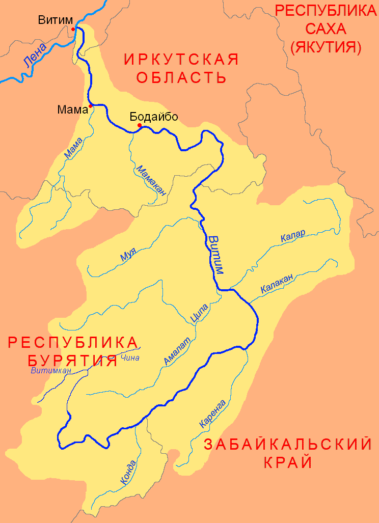
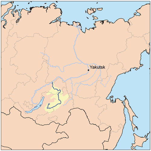
The Vitim (russian: Витим; evn, Витым, ; sah, Виитим, ; Buryat and mn, Витим, ''Vitim'') is a major tributary of the Lena. Its source is east of Lake Baikal, at the confluence of rivers Vitimkan from the west and China from the east. The Vitim flows first south, bends eastwards and then northward in the Vitim Plateau. Then it flows north through the Stanovoy Highlands and the town of Bodaybo. Including river Vitimkan, its western source, it is long, and has a drainage basin of .Витим (река в Бурят. АССР) It is navigable from the Lena to Bodaybo. Upstream, ... [...More Info...] [...Related Items...] OR: [Wikipedia] [Google] [Baidu] |
Evenks
The Evenks (also spelled Ewenki or Evenki based on their endonym )Autonym: (); russian: Эвенки (); (); formerly known as Tungus or Tunguz; mn, Хамниган () or Aiwenji () are a Tungusic people of North Asia. In Russia, the Evenks are recognised as one of the indigenous peoples of the Russian North, with a population of 38,396 ( 2010 census). In China, the Evenki form one of the 56 ethnic groups officially recognised by the People's Republic of China, with a population of 30,875 ( 2010 census). There are 537 Evenks in Mongolia (2015 census), called ''Khamnigan'' in the Mongolian language. Origin The Evenks or Ewenki are sometimes conjectured to be connected to the Shiwei people who inhabited the Greater Khingan Range in the 5th to 9th centuries, although the native land of the majority of Evenki people is in the vast regions of Siberia between Lake Baikal and the Amur River. The Ewenki language forms the northern branch of the Manchu- Tungusic language group ... [...More Info...] [...Related Items...] OR: [Wikipedia] [Google] [Baidu] |
Gold Mining
Gold mining is the extraction of gold resources by mining. Historically, mining gold from alluvial deposits used manual separation processes, such as gold panning. However, with the expansion of gold mining to ores that are not on the surface, has led to more complex extraction processes such as pit mining and gold cyanidation. In the 20th and 21st centuries, most volume of mining was done by large corporations, however the value of gold has led to millions of small, artisanal miners in many parts of the Global South. Like all mining, human rights and environmental issues are common issues in the gold mining industry. In smaller mines with less regulation, health and safety risks are much higher. History The exact date that humans first began to mine gold is unknown, but some of the oldest known gold artifacts were found in the Varna Necropolis in Bulgaria. The graves of the necropolis were built between 4700 and 4200 BC, indicating that gold mining could be at least 700 ... [...More Info...] [...Related Items...] OR: [Wikipedia] [Google] [Baidu] |
Logging
Logging is the process of cutting, processing, and moving trees to a location for transport. It may include skidding, on-site processing, and loading of trees or logs onto trucks or skeleton cars. Logging is the beginning of a supply chain that provides raw material for many products societies worldwide use for housing, construction, energy, and consumer paper products. Logging systems are also used to manage forests, reduce the risk of wildfires, and restore ecosystem functions, though their efficiency for these purposes has been challenged. In forestry, the term logging is sometimes used narrowly to describe the logistics of moving wood from the stump to somewhere outside the forest, usually a sawmill or a lumber yard. In common usage, however, the term may cover a range of forestry or silviculture activities. Illegal logging refers to the harvesting, transportation, purchase, or sale of timber in violation of laws. The harvesting procedure itself may be illegal, includin ... [...More Info...] [...Related Items...] OR: [Wikipedia] [Google] [Baidu] |
Urban-type Settlement
Urban-type settlementrussian: посёлок городско́го ти́па, translit=posyolok gorodskogo tipa, abbreviated: russian: п.г.т., translit=p.g.t.; ua, селище міського типу, translit=selyshche mis'koho typu, abbreviated: uk, с.м.т., translit=s.m.t.; be, пасёлак гарадскога тыпу, translit=pasiolak haradskoha typu; pl, osiedle typu miejskiego; bg, селище от градски тип, translit=selishte ot gradski tip; ro, așezare de tip orășenesc. is an official designation for a semi-urban settlement (previously called a "town A town is a human settlement. Towns are generally larger than villages and smaller than cities, though the criteria to distinguish between them vary considerably in different parts of the world. Origin and use The word "town" shares an ori ..."), used in several Eastern European countries. The term was historically used in Bulgaria, Poland, and the Soviet Union, and remains in use ... [...More Info...] [...Related Items...] OR: [Wikipedia] [Google] [Baidu] |
Subdivisions Of Russia
Russia is divided into several types and levels of subdivisions. Federal subjects Since 30 September 2022, the Russian Federation has consisted of eighty-nine federal subjects that are constituent members of the Federation.Constitution, Article 65 However, six of these federal subjects—the Republic of Crimea, the Donetsk People's Republic, the Russian occupation of Kherson Oblast, Kherson Oblast, the Luhansk People's Republic, Lugansk People's Republic, the federal cities of Russia, federal city of Sevastopol and the Russian occupation of Zaporizhzhia Oblast, Zaporozhye Oblast—are internationally recognized as part of Ukraine. All federal subjects are of equal federal rights in the sense that they have equal representation—two delegates each—in the Federation Council of Russia, Federation Council (upper house of the Federal Assembly of Russia, Federal Assembly). They do, however, differ in the degree of autonomous area, autonomy they enjoy. De jure, there are 6&n ... [...More Info...] [...Related Items...] OR: [Wikipedia] [Google] [Baidu] |


