|
Takamiya-juku
was the sixty-fourth of the sixty-nine stations of the Nakasendō highway connecting Edo with Kyoto in Edo period Japan. It was located in the present-day city of Hikone, Shiga Prefecture, Japan, on the right bank of the Inukami River. History Takamiya-juku has a very long history, and was a market town in front of the gates of the Shinto shrine of Taga Taisha from the end of the Nara period onwards. It was located on the ancient Tōsandō highway connecting the capital of Heian-kyō with the provinces of eastern Japan and from the early Sengoku period was a popular stopping point for pilgrims. The old stone ''torii'' gate (constructed in 1635) is still a landmark of Takamiya-juku. It is a Prefectural Important Cultural Property. In the early Edo period, the system of post stations on the Nakasendō was formalized by the Tokugawa shogunate in 1602, and it was a stopping place for traveling merchants () who originated from Ōmi Province. It was also on the ''sankin-kōtai'' ro ... [...More Info...] [...Related Items...] OR: [Wikipedia] [Google] [Baidu] |
Echigawa-juku
260px, Surviving ''hatago'' of Echigawa-juku was the sixty-fifth of the sixty-nine stations of the Nakasendō highway connecting Edo with Kyoto in Edo period Japan. It was located in the present-day town of Aishō, Echi District, Shiga Prefecture, Japan, on the east side of the Echi River. History Echigawa-juku has a very long history, and was one of the original staging points on the ancient Tōsandō highway connecting the capital of Heian-kyō with the provinces of eastern Japan from the end of the Nara period onwards. It is mentioned by name in the medieval chronicle ''Taiheiki'' as a place where Kitabatake Akiie stayed in 1336. During the Muromachi and Sengoku periods, it was a stopping place for traveling merchants () who originated from Ōmi Province. It was also known for , a local folk craft consisting of an embroidered ball inside a round glass container. In the early Edo period, the system of post stations on the Nakasendō was formalized by the Tokugawa shoguna ... [...More Info...] [...Related Items...] OR: [Wikipedia] [Google] [Baidu] |
Taga-taisha
is a Shinto shrine located in the town of Taga, Inukami District, Shiga Prefecture, Japan. The shrine is frequently referred to as by local residents. The gardens of the inner ''shoin'', which date to the Momoyama period are a nationally designated Place of Scenic Beauty, whereas the mid-Edo period ''Shoin'' itself is a Shiga Prefectural Important Cultural Property. Main ''kami'' * Izanagi * Izanami Beppyo shrines History The foundation of Taga Taisha is unknown. It is mentioned in the ancient ''Kojiki'' and '' Nihon Shoki'' chronicles from 712 AD. The shrine's legend connects it with the legendary hero Yamato Takeru, whose son, Inugami no Mitasuki was sent as an emissary to Sui China in 614 AD and the first Japanese embassy to Tang China in 630 AD. He was also the ancestor of the Inukami clan, from which Inukami District, Shiga (where the shrine is located) takes its name. However, in the 914 AD ''Engishiki'' records, it is listed only as a small shrine. From the He ... [...More Info...] [...Related Items...] OR: [Wikipedia] [Google] [Baidu] |
The Sixty-nine Stations Of The Kiso Kaidō
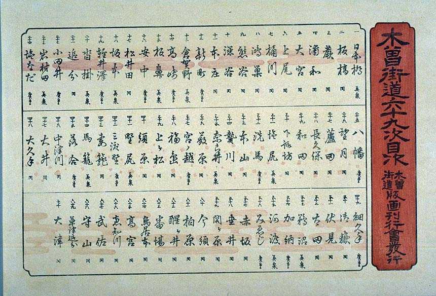
The or ''Sixty-nine Stations of the Kiso Road'', is a series of ''ukiyo-e'' works created by Utagawa Hiroshige and Keisai Eisen. There are 71 total prints in the series (one for each of the 69 post stations and Nihonbashi; Nakatsugawa-juku has two prints). The common name for the Kiso Kaidō is "Nakasendō" so the series is sometimes referred to as the ''Sixty-nine Stations of the Nakasendō''. It is a follow up to Hiroshige's ''The Fifty-three Stations of the Tōkaidō'' and he produced 47 of the prints, with Eisen being responsible for the rest.Hiroshige - Kisokaido www.hiroshige.org.uk. Accessed November 1, 2017. The series was published by Iseya Rihei (Kinjudō) from .Forrer The Naka ...
|
Hikone, Shiga
280px, Hikone City Hall is a city located in Shiga Prefecture, Japan. , the city had an estimated population of 111,958 in 49066 households and a population density of 570 persons per km². The total area of the city is . Geography Hikone is located in central Shiga Prefecture, on the eastern shore of Lake Biwa, and extending inland to the Ibuki Mountains. Parts of the city are within the borders of the Biwako Quasi-National Park. Neighboring municipalities Shiga Prefecture * Maibara *Higashiōmi * Taga * Kōra * Toyosato * Aishō Climate Hikone has a Humid subtropical climate (Köppen ''Cfa'') characterized by warm summers and cool winters with light to no snowfall. The average annual temperature in Hikone is 14.6 °C. The average annual rainfall is 1810 mm with September as the wettest month. The temperatures are highest on average in August, at around 26.4 °C, and lowest in January, at around 3.6 °C. The highest recorded temperature was 37.7 � ... [...More Info...] [...Related Items...] OR: [Wikipedia] [Google] [Baidu] |
Nakasendō
The , also called the ,Richard Lane, ''Images from the Floating World'' (1978) Chartwell, Secaucus ; pg. 285 was one of the five routes of the Edo period, and one of the two that connected Edo (modern-day Tokyo) to Kyoto in Japan. There were 69 stations (staging-posts) between Edo and Kyoto, crossing through Musashi, Kōzuke, Shinano, Mino and Ōmi provinces.Nakasendou Jouhou . NEC Corporation. Retrieved August 18, 2007. In addition to Tokyo and Kyoto, the Nakasendō runs through the modern-day prefectures of Saitama, , |
69 Stations Of The Nakasendō
The are the rest areas along the Nakasendō, which ran from Nihonbashi in Edo (modern-day Tokyo) to Sanjō Ōhashi in Kyoto.Yama to Keikoku Publishing (2006). Nakasendō o Aruku (Revised ed.). Osaka: Yama to Keikoku Publishing. .Nakasendō Jōhō . NEC Corporation. Accessed August 18, 2007. The route stretched approximately and was an alternate to the Tōkaidō. 
|
Toriimoto-juku
280px, Arikawa Akadama Jinkyokan in Toriimoto-juku (ICP) was the sixty-third of the sixty-nine stations of the Nakasendō highway connecting Edo with Kyoto in Edo period Japan. It was located in the present-day city of Hikone, Shiga Prefecture, Japan, overlooking Lake Biwa. History Toriimoto-juku has a very long history, and was a market town in front of the gates of the Shinto shrine of Taga Taisha from the end of the Nara period onwards. It was located on the ancient Tōsandō highway connecting the capital of Heian-kyō with the provinces of eastern Japan and from the early Sengoku period was a popular stopping point for pilgrims. In the early Edo period, the system of post stations on the Nakasendō was formalized by the Tokugawa shogunate in 1602, and it was a stopping place for traveling merchants () who originated from Ōmi Province. A noted local speciality was an herbal stomach medicine called , which was effective against diarrhea and food poisoning. The medicine c ... [...More Info...] [...Related Items...] OR: [Wikipedia] [Google] [Baidu] |
Inukami River
The has its source in the Suzuka Mountains in Shiga Prefecture, Japan. During the Edo period, Takamiya-juku, a post station along the Nakasendō, sat on the banks of the river in Hikone. Geography The Kitaya River (北谷川 ''Kitaya-gawa'') and the Minamiya River (南谷川 ''Minamiya-gawa''), literally the "North Valley" and "South Valley" rivers, originate in the Suzuka Mountains. The two rivers merge as they flow into Taga. The river's central portion spreads out into an alluvial fan as it flows into a plain. When the river reaches Hikone, it flows into Lake Biwa. River communities The river passes through or forms the boundary of the following communities: ;Shiga Prefecture: : Taga, Kōra, Hikone 280px, Hikone City Hall is a city located in Shiga Prefecture, Japan. , the city had an estimated population of 111,958 in 49066 households and a population density of 570 persons per km². The total area of the city is . Geography Hikone i ... References ... [...More Info...] [...Related Items...] OR: [Wikipedia] [Google] [Baidu] |
Daimyō
were powerful Japanese magnates, feudal lords who, from the 10th century to the early Meiji era, Meiji period in the middle 19th century, ruled most of Japan from their vast, hereditary land holdings. They were subordinate to the shogun and nominally to the Emperor of Japan, emperor and the ''kuge''. In the term, means 'large', and stands for , meaning 'private land'. From the ''shugo'' of the Muromachi period through the Sengoku period, Sengoku to the ''daimyo'' of the Edo period, the rank had a long and varied history. The backgrounds of ''daimyo'' also varied considerably; while some ''daimyo'' clans, notably the Mōri clan, Mōri, Shimazu clan, Shimazu and Hosokawa clan, Hosokawa, were cadet branches of the Imperial family or were descended from the ''kuge'', other ''daimyo'' were promoted from the ranks of the samurai, notably during the Edo period. ''Daimyo'' often hired samurai to guard their land, and they paid the samurai in land or food as relatively few could aff ... [...More Info...] [...Related Items...] OR: [Wikipedia] [Google] [Baidu] |
Hikone Domain
was a '' fudai'' feudal domain under the Tokugawa shogunate of Edo period Japan. It was located in eastern Ōmi Province, in the Kansai region of central Honshu. The domain was centered at Hikone Castle, located in what is now the city of Hikone in Shiga Prefecture. It was ruled throughout its history by the Ii clan. History Ii Naomasa, one of Tokugawa Ieyasu's closest advisors and most capable generals, was ''daimyō'' of Takasaki Domain with a ''kokudaka'' of 120,000 ''koku''. This was increased to 180,000 ''koku'' after the Battle of Sekigahara, and he was transferred to Sawayama Castle, on the shores of Lake Biwa, which was the former home domain of Ishida Mitsunari. The domain was thus originally named . Nussbaum, Louis Frédéric. (2005). "Ii Naomasa" in Ii Naomasa disliked living at Sawayama as it had been the home of his enemy, and planned the construction of a new castle, Hikone Castle, but died before it could be completed. His successor, Ii Naokatsu, completed th ... [...More Info...] [...Related Items...] OR: [Wikipedia] [Google] [Baidu] |
Shogun
, officially , was the title of the military dictators of Japan during most of the period spanning from 1185 to 1868. Nominally appointed by the Emperor, shoguns were usually the de facto rulers of the country, though during part of the Kamakura period, shoguns were themselves figureheads, with real power in hands of the Shikken of the Hōjō clan. The office of shogun was in practice hereditary, though over the course of the history of Japan several different clans held the position. The title was originally held by military commanders during Heian period in the eighth and ninth centuries. When Minamoto no Yoritomo gained political ascendency over Japan in 1185, the title was revived to regularize his position, making him the first shogun in the usually understood sense. The shogun's officials were collectively referred to as the ; they were the ones who carried out the actual duties of administration, while the Imperial court retained only nominal authority.Beasley, William G ... [...More Info...] [...Related Items...] OR: [Wikipedia] [Google] [Baidu] |
Honjin
The ''honjin'' at Inaba Kaidō's Ōhara-shuku.">Ōhara-shuku.html" ;"title="Inaba Kaidō's Ōhara-shuku">Inaba Kaidō's Ōhara-shuku. is the Japanese word for an inn for government officials, generally located in post stations (''shukuba'') during the later part of the Edo period. Evolution of ''Honjin'' Originally, ''honjin'' were places from which generals directed battles and, therefore, were fleeting in nature. However, as commanders began to transform the ''honjin'' into temporary lodgings during battle and travel, ''honjin'' came to be places where ''daimyō'' and other representatives of the shogunate, including ''hatamoto'', ''monzeki'', etc., were allowed to stay during their travels. Many of the ''honjin'' were actually personal residences of village and town leaders. As such, they received official designations from the government and expanded their residences to include walls, gates and other features. Because of their cooperation, the owners of the ''honjin'' also ... [...More Info...] [...Related Items...] OR: [Wikipedia] [Google] [Baidu] |


