|
Tahoe National Forest
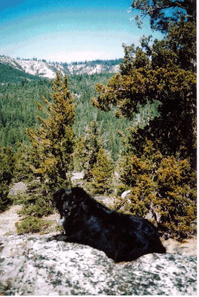
Tahoe National Forest is a United States National Forest located in California, northwest of Lake Tahoe. It includes the peak of Sierra Buttes, near Sierra City, which has views of Mount Lassen and Mount Shasta. It is located in parts of six counties: Sierra, Placer, Nevada, Yuba, Plumas and El Dorado. The forest has a total area of . Its headquarters is in Nevada City, California. There are local ranger district offices in Camptonville, Foresthill, Sierraville and Truckee. Tahoe National Forest has many natural and man-made resources for the enjoyment of its visitors, including hundreds of lakes and reservoirs (most notably Boca Reservoir), river canyons carving through granite bedrock, and many miles of trails including a portion of the Pacific Crest Trail. The National Wilderness Preservation System's Granite Chief Wilderness is close by to Tahoe City, where many trails branch out into the Wilderness. The forest also serves as the water supply headwaters for the towns ... [...More Info...] [...Related Items...] OR: [Wikipedia] [Google] [Baidu] |
Lake Tahoe
Lake Tahoe (; was, Dáʔaw, meaning "the lake") is a Fresh water, freshwater lake in the Sierra Nevada (U.S.), Sierra Nevada of the United States. Lying at , it straddles the state line between California and Nevada, west of Carson City, Nevada, Carson City. Lake Tahoe is the largest alpine lake in North America, and at it trails only the five Great Lakes as the List of lakes by volume, largest by volume in the United States. Its depth is , making it the List of lakes by depth, second deepest in the United States after Crater Lake in Oregon (). The lake was formed about two million years ago as part of the Lake Tahoe Basin, and its modern extent was shaped during the Quaternary glaciation, ice ages. It is known for the clarity of its water and the panorama of surrounding mountains on all sides. The area surrounding the lake is also referred to as Lake Tahoe, or simply Tahoe. More than 75% of the lake's Drainage basin, watershed is United States National Forest, national forest ... [...More Info...] [...Related Items...] OR: [Wikipedia] [Google] [Baidu] |
Camptonville, California
Camptonville (formerly, Comptonville and Gold Ridge) is a small town and census-designated place (CDP) located in northeastern Yuba County, California. The town is located northeast of Marysville, off Highway 49 between Downieville and Nevada City. It is located on a ridge between the North Fork and Middle Fork of the Yuba River, not far from New Bullards Bar Dam Reservoir. Camptonville lies at an elevation of 2825 feet (861 m). The population was 158 at the 2010 census. History Gold was discovered here in 1850, and the place became known as Gold Ridge. The name was changed to Camptonville in 1854 when the first post office opened. The name honors Robert Campton, the town blacksmith. It was a significant community in the California Gold Rush era and a stopping point for travelers and freight haulers along Henness Pass Road, a major route over the Sierra Nevada via Henness Pass in the 1850s and 1860s. A plaque in Camptonville says the roaring town had over fifty saloon ... [...More Info...] [...Related Items...] OR: [Wikipedia] [Google] [Baidu] |
Pyramid Lake (Nevada)
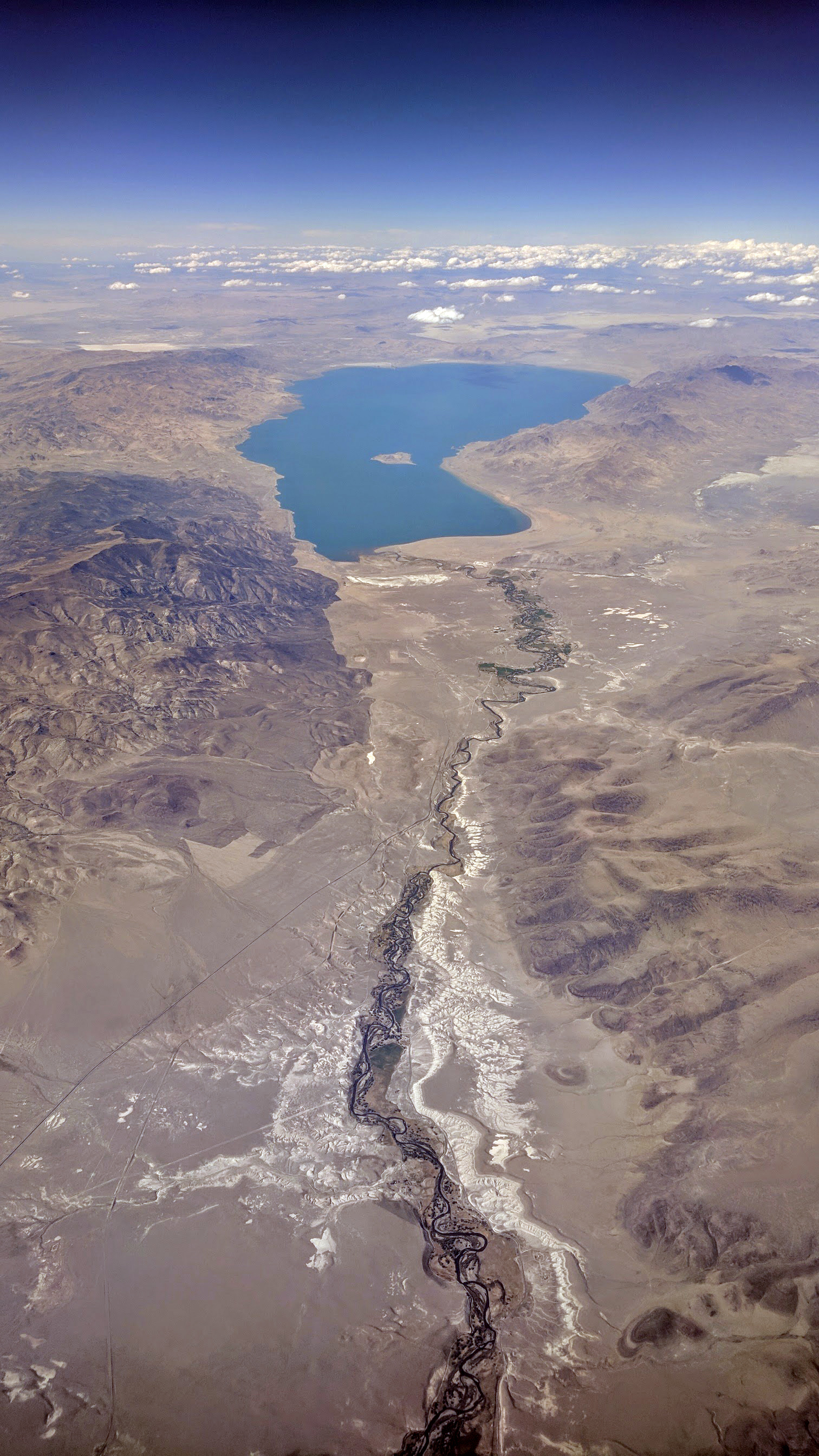
Pyramid Lake is the geographic sink of the basin of the Truckee River, northeast of Reno, Nevada, United States. Pyramid Lake is the biggest remnant of ancient Lake Lahontan, the colossal inland sea that once covered most of Nevada. It is approximately 15 miles long and 11 miles wide, covering 112,000 acres entirely enclosed within the Pyramid Lake Paiute Tribe Reservation. Pyramid Lake is fed by the Truckee River, which is mostly the outflow from Lake Tahoe. The Truckee River enters Pyramid Lake at its southern end. Pyramid Lake is an endorheic lake. It has no outlet, with water left only by evaporation, or sub-surface seepage. The lake has about 10% of the area of the Great Salt Lake, but it has about 25% more volume. The salinity is approximately 1/6 that of sea water. Although clear Lake Tahoe forms the headwaters that drain to Pyramid Lake, the Truckee River delivers more turbid waters to Pyramid Lake after traversing the steep Sierra terrain and collecting moderately hi ... [...More Info...] [...Related Items...] OR: [Wikipedia] [Google] [Baidu] |
Sparks, Nevada
Sparks is a city in Washoe County, Nevada, United States. It was founded in 1904, incorporated on March 15, 1905, and is located just east of Reno. The 2020 U.S. Census counted 108,445 residents in the city. It is the fifth most populous city in Nevada. It is named after John Sparks, Nevada Governor (1903–1908), and a member of the Silver Party. Sparks is located within the Reno–Sparks metropolitan area. History Euro-American settlement began in the early 1850s, and the population density remained very low until 1904 when the Southern Pacific Railroad built a switch yard and maintenance sheds there, after moving the division point from Wadsworth. In 1902, The Southern Pacific purchased a large tract of swamp-like land near its newly built railyard, and gave everyone clear deed to a lot for the sum of $1. They also offered to pick up and move every house in Wadsworth and reassemble it in this new town free of charge. As the population increased, a city was established, f ... [...More Info...] [...Related Items...] OR: [Wikipedia] [Google] [Baidu] |
Reno, Nevada
Reno ( ) is a city in the northwest section of the U.S. state of Nevada, along the Nevada-California border, about north from Lake Tahoe, known as "The Biggest Little City in the World". Known for its casino and tourism industry, Reno is the county seat and largest city of Washoe County and sits in the High Eastern Sierra foothills, in the Truckee River valley, on the eastern side of the Sierra Nevada. The Reno metro area (along with the neighboring city Sparks) occupies a valley colloquially known as the Truckee Meadows which because of large-scale investments from Greater Seattle and San Francisco Bay Area companies such as Amazon, Tesla, Panasonic, Microsoft, Apple, and Google has become a new major technology center in the United States. The city is named after Civil War Union Major General Jesse L. Reno, who was killed in action during the American Civil War at the Battle of South Mountain, on Fox's Gap. Reno is part of the Reno–Sparks metropolitan area, the ... [...More Info...] [...Related Items...] OR: [Wikipedia] [Google] [Baidu] |
Rocklin, California
Rocklin is a city in Placer County, California, about from Sacramento, and about northeast of Roseville in the Sacramento metropolitan area. Besides Roseville, it shares borders with Granite Bay, Loomis and Lincoln. As of the 2010 census, Rocklin's population was 56,974. The California Department of Finance placed the 2019 population at 68,823. History Before the California Gold Rush, the Nisenan Maidu occupied both permanent villages and temporary summer shelters along the rivers and streams that miners sifted, sluiced, dredged and dammed to remove the gold. Explorer Jedediah Smith and a large party of American fur trappers crossed the Sacramento Valley in April 1827. The group saw many Maidu villages along the river banks. Deprived of traditional foodstuffs, homesites and hunting grounds by the emigrants, the Nisenan were among the earliest California Indian tribes to disappear. During the 1850s, miners sluiced streams and rivers, including Secret Ravine, which runs throu ... [...More Info...] [...Related Items...] OR: [Wikipedia] [Google] [Baidu] |
Auburn, California
Auburn is a city in and the county seat of Placer County, California, United States. Its population was 13,776 during the 2020 census. Auburn is known for its California Gold Rush history and is registered as a California Historical Landmark. Auburn is part of the Sacramento metropolitan area. History Archaeological finds place the southwestern border for the prehistoric Martis people in the Auburn area. The indigenous Nisenan, an offshoot of the Maidu, were the first to establish a permanent settlement in the Auburn area. In the spring of 1848, a group of French gold miners arrived and camped in what would later be known as the Auburn Ravine. This group was on its way to the gold fields in Coloma, California, and it included Francois Gendron, Philibert Courteau, and Claude Chana. The young Chana discovered gold on May 16, 1848. After finding the gold deposits in the soil, the trio decided to stay for more prospecting and mining. Placer mining in the Auburn area was very goo ... [...More Info...] [...Related Items...] OR: [Wikipedia] [Google] [Baidu] |
Lincoln, California
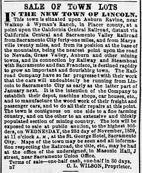
Lincoln is a city in Placer County, California, United States, part of the Sacramento metropolitan area. Located in an area of rapid suburban development, it grew 282.1 percent between 2000 and 2010, making it the fastest-growing city over 10,000 people in the U.S. Its 2019 population was estimated to be 48,275. Lincoln is part of the Sacramento-Roseville Metropolitan Statistical Area. History The original townsite was surveyed and laid out in 1859 by Theodore Judah along the proposed line of the California Central Railroad. The name "Lincoln" was conferred in honor of Charles Lincoln Wilson, one of the organizers, a fundraiser, and management contractor of the California Central Railroad (CCRR). The CCRR was planned as a rail link between the cities of Marysville and Sacramento via a connection to the Sacramento Valley Railroad in Folsom. Grading from Folsom to Marysville commenced in 1858 and was completed to Grider's Ranch ( Roseville) by 1859. At Auburn Ravine, where ... [...More Info...] [...Related Items...] OR: [Wikipedia] [Google] [Baidu] |
Granite Chief Wilderness
The Granite Chief Wilderness is a 19,048 acre (77 km2) federally designated wilderness area of the Tahoe National Forest. Created by the California Wilderness Act of 1984, it is located in the Sierra Nevada mountains west of Lake Tahoe in the U.S. state of California. It is managed by the U.S. Forest Service Tahoe National Forest. Elevations range from to at the summit of Granite Chief. Events such as the Western States Endurance Run and the equestrian Western States Trail Ride, (popularly called The Tevis Cup) cross portions of the wilderness. The Pacific Crest Trail also passes through along the east edge of the wilderness. This region is extensively glaciated and has features such as hanging valleys, cirques and U-shaped valleys, but few lakes. Just outside the wilderness boundary there are two large recreation reservoirs, Hell Hole Reservoir to the south and French Meadows Reservoir to the west. The Sierra Club had maintained the Bradley Hut, which was a ski ... [...More Info...] [...Related Items...] OR: [Wikipedia] [Google] [Baidu] |
National Wilderness Preservation System
The National Wilderness Preservation System (NWPS) of the United States protects federally managed wilderness areas designated for preservation in their natural condition. Activity on formally designated wilderness areas is coordinated by the National Wilderness Preservation System. Wilderness areas are managed by four federal land management agencies: the National Park Service, the U.S. Forest Service, the U.S. Fish and Wildlife Service, and the Bureau of Land Management. The term ''wilderness'' is defined as "an area where the earth and community of life are untrammeled by man, where man himself is a visitor who does not remain" and "an area of undeveloped Federal land retaining its primeval character and influence, without permanent improvements or human habitation, which is protected and managed so as to preserve its natural conditions". , 803 wilderness areas have been designated, totaling , which comprise about 4.5% of the land area of the United States. History During ... [...More Info...] [...Related Items...] OR: [Wikipedia] [Google] [Baidu] |
Pacific Crest Trail
The Pacific Crest Trail (PCT), officially designated as the Pacific Crest National Scenic Trail, is a long-distance hiking and equestrian trail closely aligned with the highest portion of the Cascade and Sierra Nevada mountain ranges, which lie east of the U.S. Pacific coast. The trail's southern terminus is next to the Mexico–United States border, just south of Campo, California, and its northern terminus is on the Canada–US border, upon which it continues unofficially to the Windy Joe Trail within Manning Park in British Columbia; it passes through the states of California, Oregon, and Washington. The Pacific Crest Trail is long and ranges in elevation from roughly above sea level near the Bridge of the Gods on the Oregon–Washington border to at Forester Pass in the Sierra Nevada. The route passes through 25 national forests and 7 national parks. Its midpoint is near Chester, California (near Mt. Lassen), where the Sierra and Cascade mountain ranges meet. It was d ... [...More Info...] [...Related Items...] OR: [Wikipedia] [Google] [Baidu] |
Granite
Granite () is a coarse-grained (phaneritic) intrusive igneous rock composed mostly of quartz, alkali feldspar, and plagioclase. It forms from magma with a high content of silica and alkali metal oxides that slowly cools and solidifies underground. It is common in the continental crust of Earth, where it is found in igneous intrusions. These range in size from dikes only a few centimeters across to batholiths exposed over hundreds of square kilometers. Granite is typical of a larger family of ''granitic rocks'', or ''granitoids'', that are composed mostly of coarse-grained quartz and feldspars in varying proportions. These rocks are classified by the relative percentages of quartz, alkali feldspar, and plagioclase (the QAPF classification), with true granite representing granitic rocks rich in quartz and alkali feldspar. Most granitic rocks also contain mica or amphibole minerals, though a few (known as leucogranites) contain almost no dark minerals. Granite is nearly alway ... [...More Info...] [...Related Items...] OR: [Wikipedia] [Google] [Baidu] |


