|
TACAN
A tactical air navigation system, commonly referred to by the acronym TACAN, is a navigation system used by military aircraft. It provides the user with bearing and distance (slant-range or hypotenuse) to a ground or ship-borne station. It is a more accurate version of the VOR/ DME system that provides bearing and range information for civil aviation. The DME portion of the TACAN system is available for civil use; at VORTAC facilities where a VOR is combined with a TACAN, civil aircraft can receive VOR/DME readings. Aircraft equipped with TACAN avionics can use this system for en route navigation as well as non-precision approaches to landing fields. The Space Shuttle is one such vehicle that was designed to use TACAN navigation but later upgraded with GPS as a replacement. The typical TACAN onboard user panel has control switches for setting the channel (corresponding to the desired surface station's assigned frequency), the operation mode for either transmit/receive (T/R, to get ... [...More Info...] [...Related Items...] OR: [Wikipedia] [Google] [Baidu] |
Battle Of Lima Site 85
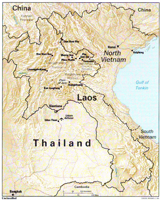
The Battle of Lima Site 85, also called Battle of Phou Pha Thi, was fought as part of a military campaign waged during the Vietnam War and Laotian Civil War by the North Vietnamese People's Army of Vietnam (PAVN) and the Pathet Lao, against airmen of the United States Air Force (USAF)'s 1st Combat Evaluation Group, elements of the Royal Lao Army, Royal Thai Border Patrol Police, and the Central Intelligence Agency-led Hmong Clandestine Army. The battle was fought on Phou Pha Thi mountain in Houaphanh Province, Laos, on 10 March 1968, and derives its name from the mountaintop where it was fought or from the designation of a landing strip in the valley below, and was the largest single ground combat loss of United States Air Force members during the Vietnam War. During the Vietnam War and the Laotian Civil War, Phou Pha Thi mountain was an important strategic outpost which had served both sides at various stages of the conflict. In 1966, the United States Ambassador ... [...More Info...] [...Related Items...] OR: [Wikipedia] [Google] [Baidu] |
VHF Omnidirectional Range
Very high frequency omnirange station (VOR) is a type of short-range radio navigation system for aircraft, enabling aircraft with a receiving unit to determine its position and stay on course by receiving radio signals transmitted by a network of fixed ground radio beacons. It uses frequencies in the very high frequency (VHF) band from 108.00 to 117.95 MHz. Developed in the United States beginning in 1937 and deployed by 1946, VOR became the standard air navigational system in the world,VOR VHF omnidirectional Range , Aviation Tutorial – Radio Navaids, kispo.net used by both commercial and general aviation, until supplanted by satellite navigation systems such as in th ... [...More Info...] [...Related Items...] OR: [Wikipedia] [Google] [Baidu] |
VORTAC
Very high frequency omnirange station (VOR) is a type of short-range radio navigation system for aircraft, enabling aircraft with a receiving unit to determine its position and stay on course by receiving radio signals transmitted by a network of fixed ground radio beacons. It uses frequencies in the very high frequency (VHF) band from 108.00 to 117.95 MHz. Developed in the United States beginning in 1937 and deployed by 1946, VOR became the standard air navigational system in the world,VOR VHF omnidirectional Range , Aviation Tutorial – Radio Navaids, kispo.net used by both commercial and general aviation, until supplanted by satellite navigation systems such as in th ... [...More Info...] [...Related Items...] OR: [Wikipedia] [Google] [Baidu] |


