|
Tōnankai Earthquakes
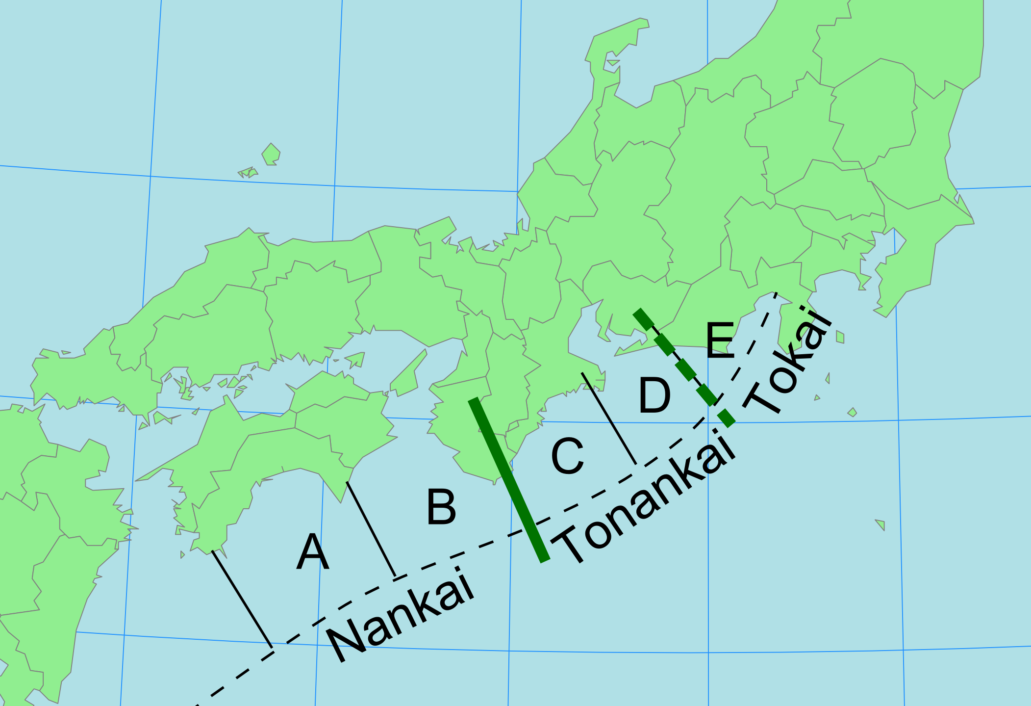
The Tōnankai earthquakes are major megathrust earthquakes that affect the Tōnankai region (Southeastern Sea) of Japan, between the Tōkai region (Eastern Sea) and Nankaidō (Southern Sea Circuit) region, and are caused by ruptures in the Tōnankai zone of the Nankai megathrust, specifically segments C and/or D. These are a class of Nankai megathrust earthquakes, frequently occurring in combination with a rupture of segment E (Tōkai zone, yielding Tōkai earthquakes), and either in combination with or followed by a rupture of segment A and/or B (Nankai zone, yielding Nankai earthquakes). The most notable Tōnankai earthquake, and the only earthquake known to have consisted of ruptures in the Tōnankai zone only, is the 1944 Tōnankai earthquake. History The distinction of Tōnankai earthquakes, and the Tōnankai region itself, is a recent one, dating to the 1944 Tōnankai earthquake The 1944 Tōnankai earthquake occurred at 13:35 local time (04:35 UTC) on 7 December. It ha ... [...More Info...] [...Related Items...] OR: [Wikipedia] [Google] [Baidu] |
Megathrust Earthquake
Megathrust earthquakes occur at convergent plate boundaries, where one tectonic plate is forced underneath another. The earthquakes are caused by slip along the thrust fault that forms the contact between the two plates. These interplate earthquakes are the planet's most powerful, with moment magnitudes (''Mw'') that can exceed 9.0. Since 1900, all earthquakes of magnitude 9.0 or greater have been megathrust earthquakes. The thrust faults responsible for megathrust earthquakes often lie at the bottom of oceanic trenches; in such cases, the earthquakes can abruptly displace the sea floor over a large area. As a result, megathrust earthquakes often generate tsunamis that are considerably more destructive than the earthquakes themselves. Teletsunamis can cross ocean basins to devastate areas far from the original earthquake. Terminology and mechanism The term ''megathrust'' refers to an extremely large thrust fault, typically formed at the plate interface along a subduction zone ... [...More Info...] [...Related Items...] OR: [Wikipedia] [Google] [Baidu] |
Japan
Japan ( ja, 日本, or , and formally , ''Nihonkoku'') is an island country in East Asia. It is situated in the northwest Pacific Ocean, and is bordered on the west by the Sea of Japan, while extending from the Sea of Okhotsk in the north toward the East China Sea, Philippine Sea, and Taiwan in the south. Japan is a part of the Ring of Fire, and spans Japanese archipelago, an archipelago of List of islands of Japan, 6852 islands covering ; the five main islands are Hokkaido, Honshu (the "mainland"), Shikoku, Kyushu, and Okinawa Island, Okinawa. Tokyo is the Capital of Japan, nation's capital and largest city, followed by Yokohama, Osaka, Nagoya, Sapporo, Fukuoka, Kobe, and Kyoto. Japan is the List of countries and dependencies by population, eleventh most populous country in the world, as well as one of the List of countries and dependencies by population density, most densely populated and Urbanization by country, urbanized. About three-fourths of Geography of Japan, the c ... [...More Info...] [...Related Items...] OR: [Wikipedia] [Google] [Baidu] |
Tōkai Region
The is a subregion of the Chūbu region and Kansai region in Japan that runs along the Pacific Ocean. The name comes from the Tōkaidō, one of the Edo Five Routes. Because Tōkai is a sub-region and is not officially classified, there is some disagreement about where exactly the region begins and ends, however Japanese maps widely conclude that the region includes Shizuoka, Aichi, Gifu and Mie prefectures. The largest major city in the region is Nagoya and the Chūkyō Metropolitan Area (Nagoya Metropolitan Area) makes up a large portion of the region and has Japan's third strongest economy. The business influence of this urban area sometimes extends out into the outlying areas of the three prefectures centered on Nagoya which are Aichi, Gifu, and Mie; this area is sometimes referred to as the Chūkyō region. Tōkai is a heavy manufacturing area and is one of the most industrial regions in Japan. Its coast is lined with densely populated cities with economies that thr ... [...More Info...] [...Related Items...] OR: [Wikipedia] [Google] [Baidu] |
Nankaidō
is a Japanese geographical term. It means both an ancient division of the country and the main road running through it. The road connected provincial capitals in this region. It was part of the Gokishichidō system. The ''Nankaidō'' encompassed the pre-Meiji provincial lands of Kii and Awaji, plus the four provinces that made up the island of Shikoku: Awa, Sanuki, Tosa, and Iyo. The road extended from Nara to the seacoast to the south on the Kii Peninsula of the island of Honshū in Japan and crossing the sea, extended to Yura (nowadays Sumoto) and then Shikoku. Nankaidō earthquakes :''See Historic tsunami for a full list of Nankai quakes with tsunami.'' Many historic earthquakes bear the name "Nankai" or "Nankaido", as specific epicenters were known at the time. Often quakes take on the Japanese era name along with location such as Nankaido. These include: *1498 Meiō Nankaidō earthquake * 1605 Keichō Nankaidō earthquake * 1854 Ansei-Nankai earthquake *1944 Tōna ... [...More Info...] [...Related Items...] OR: [Wikipedia] [Google] [Baidu] |
Nankai Megathrust
The is a submarine Trough (geology), trough located south of the Nankaidō region of Japan's island of Honshu, extending approximately offshore. The underlying Fault (geology), fault, the ''Nankai megathrust,'' is the source of the devastating Nankai megathrust earthquakes, while the trough itself is potentially a major source of hydrocarbon fuel, in the form of methane clathrate. In plate tectonics, the Nankai Trough marks a subduction zone that is caused by subduction of the Philippine Sea Plate beneath Japan, part of the Eurasian plate (Kanda et al., 2004). This plate boundary would be an oceanic trench except for a high flux of sediments that fills the trench. Within the Nankai Trough there is a large amount of deformed trench sediments (Ike, 2004), making one of Earth's best examples of accretionary prism. Furthermore, seismic reflection studies have revealed the presence of basement highs that are interpreted as seamounts that are covered in sediments (Ike, 2004). The nort ... [...More Info...] [...Related Items...] OR: [Wikipedia] [Google] [Baidu] |
Nankai Megathrust Earthquakes
Nankai megathrust earthquakes are great megathrust earthquakes that occur along the ''Nankai megathrust'' – the fault under the Nankai Trough – which forms the plate interface between the subducting Philippine Sea Plate and the overriding Amurian Plate (part of the Eurasian Plate), which dips beneath southwestern Honshu, Japan. The fault is divided into five segments in three zones, which rupture separately or in combination, and depending on location, the resulting earthquakes are subdivided by zone from west to east into Nankai earthquakes, Tōnankai earthquakes, and Tōkai earthquakes. The earthquakes occur with a return period of about 90–200 years, and often occur in pairs, where a rupture along one part of the fault is followed by a rupture elsewhere on the fault, notably the 1854 Ansei-Tōkai earthquake and the 1854 Ansei-Nankai earthquake the next day, and the 1944 Tōnankai earthquake, followed by the 1946 Nankaidō earthquake. In one recorded case (the 1707 Hōe ... [...More Info...] [...Related Items...] OR: [Wikipedia] [Google] [Baidu] |
Tōkai Earthquakes
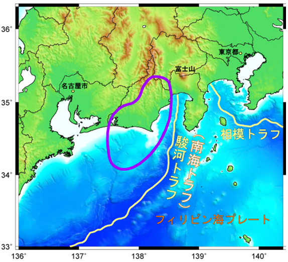
The Tōkai earthquakes () are major earthquakes that have occurred regularly with a return period of 100 to 150 years in the Tōkai region of Japan. The Tōkai segment has been struck by earthquakes in 1498, 1605, 1707, 1854, and 1923. Given the historic regularity of these earthquakes, Kiyoo Mogi in 1969 pointed out that another great shallow earthquake was possible in the "near future" (i.e., in the next few decades). Given the magnitude of the last two earthquakes, the next is expected to have at least a magnitude scale of 8.0 , with large areas shaken at the highest level in the Japanese intensity scale, 7. Emergency planners are anticipating and preparing for potential scenarios after such an earthquake, including the possibility of thousands of deaths and hundreds of thousands of injuries, millions of damaged buildings, and cities that include Nagoya and Shizuoka devastated. Concern has been expressed over the presence of the Hamaoka Nuclear Power Plant, close to the expecte ... [...More Info...] [...Related Items...] OR: [Wikipedia] [Google] [Baidu] |
Nankai Earthquakes
The are major megathrust earthquakes that affect the Nankaidō (Southern Sea Circuit) region of Japan, west of the Tōnankai region (Southeastern Sea) and Tōkai region (Eastern Sea), and are caused by ruptures in the Nankai zone of the Nankai megathrust, specifically segments A and/or B. They occur with a return period of 100 to 200 years, and there is a high probability of one in the 21st century, as the most recent was the 1946 Nankaidō earthquake. These have high destructive potential, and thus are a focus of earthquake preparation.These are a class of Nankai megathrust earthquakes, frequently occurring in combination with, or following, a rupture of segments C and/or D (Tōnankai zone, yielding Tōnankai earthquakes) and sometimes segment E (Tōkai zone, yielding Tōkai earthquakes). They are also known as . History Historical Nankai earthquakes are as follows; some of these coincided with or followed earthquakes in the Tōnankai or Tōkai zones, and the 1498 Meiō Na ... [...More Info...] [...Related Items...] OR: [Wikipedia] [Google] [Baidu] |
1944 Tōnankai Earthquake
The 1944 Tōnankai earthquake occurred at 13:35 local time (04:35 UTC) on 7 December. It had an estimated magnitude of 8.1 on the moment magnitude scale (making it the strongest known earthquake of 1944) and a maximum felt intensity of greater than 5 Shindo (about VIII (''Severe'') on the Mercalli intensity scale). It triggered a large tsunami that caused serious damage along the coast of Wakayama Prefecture and the Tōkai region. Together, the earthquake and tsunami caused 3,358 casualties. Tectonic setting The southern coast of Honshū runs parallel to the Nankai Trough, which marks the subduction of the Philippine Sea Plate beneath the Eurasian Plate. Movement on this convergent plate boundary leads to many earthquakes, some of them of megathrust type. The Nankai megathrust has five distinct segments (A–E) that can rupture independently, the segments have ruptured either singly or together repeatedly over the last 1300 years. Megathrust earthquakes on this structure tend ... [...More Info...] [...Related Items...] OR: [Wikipedia] [Google] [Baidu] |
Megathrust Earthquakes In Japan
Megathrust earthquakes occur at convergent plate boundaries, where one tectonic plate is forced underneath another. The earthquakes are caused by slip along the thrust fault that forms the contact between the two plates. These interplate earthquakes are the planet's most powerful, with moment magnitudes (''Mw'') that can exceed 9.0. Since 1900, all earthquakes of magnitude 9.0 or greater have been megathrust earthquakes. The thrust faults responsible for megathrust earthquakes often lie at the bottom of oceanic trenches; in such cases, the earthquakes can abruptly displace the sea floor over a large area. As a result, megathrust earthquakes often generate tsunamis that are considerably more destructive than the earthquakes themselves. Teletsunamis can cross ocean basins to devastate areas far from the original earthquake. Terminology and mechanism The term ''megathrust'' refers to an extremely large thrust fault, typically formed at the plate interface along a subduction zone ... [...More Info...] [...Related Items...] OR: [Wikipedia] [Google] [Baidu] |


