|
Tulsi Lake
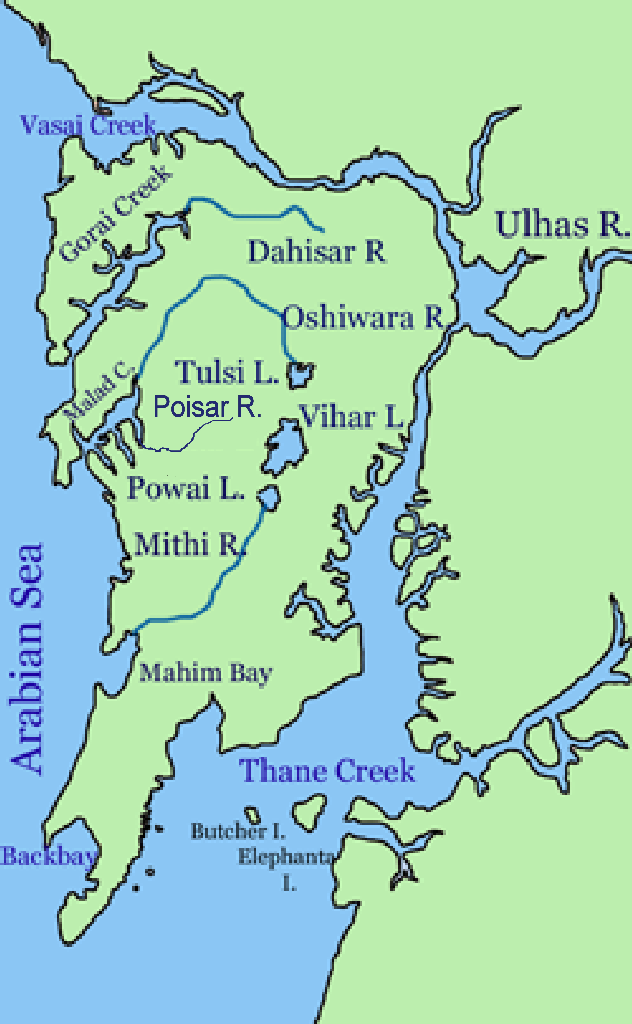
Tulsi Lake is a fresh water lake in northern Mumbai. It is stated to be the second largest lake in Mumbai and supplies part of the city's potable water. This is one of the three lakes located in the Salsette Island; the other two being Powai Lake and Vihar Lake. Both Tulsi lake and Vihar lake are located within the densely forested Sanjay Gandhi National Park or also known popularly as the Borivali National Park (BNP). Hydrology Tulsi Lake was built by damming the River Tasso, and redirecting the flow to the nearby Vihar Lake. Rain water from the catchment area of 676 hectares of Powai-Kanheri hill ranges drains into the lake. During the rainy season the flood flows out flows into the Powai Lake and further down into the Mithi River. The maximum height of hill in the catchment is about 400 m. The southwest monsoon sets in by mid June and lasts till September. The maximum rainfall is normally recorded in the months of July and August. The mean annual rainfall is reported to ... [...More Info...] [...Related Items...] OR: [Wikipedia] [Google] [Baidu] |
Sanjay Gandhi National Park
Sanjay Gandhi National Park, also known as SGNP, is an protected area in Mumbai, Maharashtra. It was established in 1969 with its headquarters situated at Borivali. The 2400-year-old Kanheri caves, sculpted by monks out of the rocky basaltic cliffs, lie within the park. The rich flora and fauna of the Sanjay Gandhi National Park attract more than 2 million visitors every year. History The area of the Sanjay Gandhi National Park has a long written history dating back to the 4th Century BCE. In Ancient India, Sopara and Kalyan were two ports in its vicinity that traded with ancient civilisations such as Greece and Mesopotamia. The land route between these two ports was partially passing through this forest. The Kanheri caves, located centrally in the park, were important Buddhist learning centres and pilgrimage sites sculpted by Buddhist monks (using primitive sculpting tools) between the 9th and the 1st centuries BCE. They were chiselled out of a massive basaltic rock outcr ... [...More Info...] [...Related Items...] OR: [Wikipedia] [Google] [Baidu] |
Powai
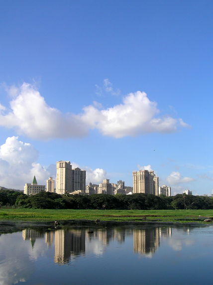
Powai (Pronunciation: əʋəiː is an upscale residential neighbourhood located in central Mumbai, Maharashtra, India. It is situated on the banks of Powai Lake, and is bound by the hills of Vikhroli Parksite to the south-east, Chandivali to the south-west, the L.B.S. Marg (old Mumbai-Agra road) to the north-east and the Sanjay Gandhi National Park to the north beyond the lake. The Jogeshwari-Vikhroli Link Road, one of the city's busiest thoroughfares linking the western and eastern suburbs, passes through Powai,. The place also hosts thousands of devotees every year during the Ganesh Chaturthi festival for the ''visarjan'' processions. The Indian Institute of Technology, Bombay, established in 1958 and currently the second oldest campus of the Indian Institutes of Technology as well as the National Institute of Industrial Engineering, established in 1963 are both located here, as is a campus of the Bombay Scottish School. Powai is also home to residential complexes of the ... [...More Info...] [...Related Items...] OR: [Wikipedia] [Google] [Baidu] |
Mumbai's Water Sources
Mumbai controls several dams in Shahpur taluk (Thane district) that deliver water to the city. The Western Ghats trap most of the moisture laden monsoon clouds which feed these dammed rivers. Currently, these dams deliver approximately 3.4 billion litres of water to Mumbai daily. Here are the dams supplying the city the water it needs to survive: Tansa and Vaitarna dams supply the southern region of Mumbai, while the rest supply the suburbs. An underground tank in Malabar Hill Malabar Hill (ISO: Malabār Hill ələbaːɾ is a hillock and upmarket residential neighbourhood in South Mumbai, Maharashtra, India. Malabar Hill is the most exclusive residential area in Mumbai. It is home to several business tycoons and f ...s is used to store the water. References Geography of Mumbai Water supply and sanitation in India {{Maharashtra-stub ... [...More Info...] [...Related Items...] OR: [Wikipedia] [Google] [Baidu] |
Crocodilus Palustris
''Crocodylus'' is a genus of true crocodiles in the family Crocodylidae. Taxonomy The generic name, ''Crocodylus'', was proposed by Josephus Nicolaus Laurenti in 1768. ''Crocodylus'' contains 13–14 extant (living) species and 5 extinct species. There are additional extinct species attributed to the genus ''Crocodylus'' that studies have shown no longer belong, although they have not yet been reassigned to new genera. Extant species The 13–14 living species are: Fossils ''Crocodylus'' also includes five extinct species: * † '' Crocodylus anthropophagus'' is an extinct crocodile from Plio-Pleistocene of Tanzania. * † ''Crocodylus checchiai'' is an extinct crocodile from Late Miocene of Kenya. * † '' Crocodylus falconensis'' is an extinct crocodile from Early Pliocene of Venezuela. * † ''Crocodylus palaeindicus'' is an extinct crocodile the Miocene to the Pleistocene of southern Asia. * † ''Crocodylus thorbjarnarsoni'' is an extinct crocodile from Plio-Pleisto ... [...More Info...] [...Related Items...] OR: [Wikipedia] [Google] [Baidu] |
Marsh Crocodiles
A marsh is a wetland that is dominated by herbaceous rather than woody plant species.Keddy, P.A. 2010. Wetland Ecology: Principles and Conservation (2nd edition). Cambridge University Press, Cambridge, UK. 497 p Marshes can often be found at the edges of lakes and streams, where they form a transition between the aquatic and terrestrial ecosystems. They are often dominated by grasses, rushes or reeds. If woody plants are present they tend to be low-growing shrubs, and the marsh is sometimes called a carr. This form of vegetation is what differentiates marshes from other types of wetland such as swamps, which are dominated by trees, and mires, which are wetlands that have accumulated deposits of acidic peat. Marshes provide habitats for many kinds of invertebrates, fish, amphibians, waterfowl and aquatic mammals. This biological productivity means that marshes contain 0.1% of global sequestered terrestrial carbon. Moreover, they have an outsized influence on climate res ... [...More Info...] [...Related Items...] OR: [Wikipedia] [Google] [Baidu] |
Sahar International Airport
Chhatrapati Shivaji Maharaj International Airport is an international airport serving Mumbai and the Mumbai Metropolitan Region (MMR). It is the second busiest airport in the country in terms of total and international passenger traffic after Delhi, and was the 14th busiest airport in Asia and 41st busiest airport in the world by passenger traffic in calendar year 2019. Its passenger traffic was about 49.8 million in year 2018. It is also the second busiest airport in terms of cargo traffic. In March 2017, the airport surpassed London's Gatwick Airport as the world's busiest to operate a single runway at a time. This was later surpassed again by Gatwick Airport at the end of 2019 due to passenger numbers falling at Mumbai. The airport's IATA code ''BOM'' is associated with "Bombay", the city's former legal name. It has two operating terminals spread over a total land area of and handles about 950 aircraft movements per day. It handled a record of 1,007 aircraft mov ... [...More Info...] [...Related Items...] OR: [Wikipedia] [Google] [Baidu] |
Greater Mumbai
Mumbai (, ; also known as Bombay — the official name until 1995) is the capital city of the Indian state of Maharashtra and the ''de facto'' financial centre of India. According to the United Nations, as of 2018, Mumbai is the second-most populous city in India after Delhi and the eighth-most populous city in the world with a population of roughly 20 million (2 crore). As per the Indian government population census of 2011, Mumbai was the most populous city in India with an estimated city proper population of 12.5 million (1.25 crore) living under the Brihanmumbai Municipal Corporation. Mumbai is the centre of the Mumbai Metropolitan Region, the sixth most populous metropolitan area in the world with a population of over 23 million (2.3 crore). Mumbai lies on the Konkan coast on the west coast of India and has a deep natural harbour. In 2008, Mumbai was named an Globalization and World Cities Research Network, alpha world city. It has the highest number of m ... [...More Info...] [...Related Items...] OR: [Wikipedia] [Google] [Baidu] |
Mithi River
The Mithi River (Pronunciation: iʈʰiː is a river on Salsette Island, the island of the city of Mumbai, India. It is a confluence of tail-water discharges of the Powai and Vihar lakes. The river is seasonal and rises during the monsoons. The overflowing lakes also contribute to the river flow, which is stopped by a dam at other times. During this season, the gutter is a favourite with anglers, who can catch large fish that have escaped from the lakes. Chattrapati Shivaji Maharaj International Airport is located right next to the section of river at Andheri (E). Geography The river originates from the overflow of Vihar Lake and also receives the overflows from the Powai Lake about 2 km later. It flows for a total of 18 km before it meets the Arabian Sea at Mahim Creek flowing through residential and industrial complexes of Powai, Saki Naka, Kurla, Kalina, Vakola, Bandra-Kurla complex, Dharavi and Mahim. The river has an average width of 5 metres in the upper rea ... [...More Info...] [...Related Items...] OR: [Wikipedia] [Google] [Baidu] |
Kanheri
The Kanheri Caves (''Kānherī-guhā'' aːnʱeɾiː ɡuɦaː are a group of caves and rock-cut monuments cut into a massive basalt outcrop in the forests of the Sanjay Gandhi National Park, on the former island of Salsette in the western outskirts of Mumbai, India. They contain Buddhist sculptures and relief carvings, paintings and inscriptions, dating from the 1st century CE to the 10th century CE. ''Kanheri'' comes from the Sanskrit ''Krishnagiri'', which means black mountain. The site is on a hillside, and is accessible via rock-cut steps. The cave complex comprises one hundred and nine caves. The oldest are relatively plain and unadorned, in contrast to later caves on the site, and the highly embellished Elephanta Caves of Mumbai. Each cave has a stone plinth that functioned as a bed. A congregation hall with huge stone pillars contains a stupa (a Buddhist Pagoda). Rock-cut channels above the caves fed rainwater into cisterns, which provided the complex with water. Once th ... [...More Info...] [...Related Items...] OR: [Wikipedia] [Google] [Baidu] |
River Tasso
River Tasso is a river in Mumbai (Bombay), India which empties into the Vihar Lake. It originates in the Sanjay Gandhi National Park. In 1872, the plan was made to dam and redirect the river into the Tulsi Lake Tulsi Lake is a fresh water lake in northern Mumbai. It is stated to be the second largest lake in Mumbai and supplies part of the city's potable water. This is one of the three lakes located in the Salsette Island; the other two being Powai ... at a then cost of Rs. 40 lakh (4,000,000). References Lakes of Mumbai Rivers of Mumbai {{India-river-stub ... [...More Info...] [...Related Items...] OR: [Wikipedia] [Google] [Baidu] |
India
India, officially the Republic of India (Hindi: ), is a country in South Asia. It is the seventh-largest country by area, the second-most populous country, and the most populous democracy in the world. Bounded by the Indian Ocean on the south, the Arabian Sea on the southwest, and the Bay of Bengal on the southeast, it shares land borders with Pakistan to the west; China, Nepal, and Bhutan to the north; and Bangladesh and Myanmar to the east. In the Indian Ocean, India is in the vicinity of Sri Lanka and the Maldives; its Andaman and Nicobar Islands share a maritime border with Thailand, Myanmar, and Indonesia. Modern humans arrived on the Indian subcontinent from Africa no later than 55,000 years ago., "Y-Chromosome and Mt-DNA data support the colonization of South Asia by modern humans originating in Africa. ... Coalescence dates for most non-European populations average to between 73–55 ka.", "Modern human beings—''Homo sapiens''—originated in Africa. Then, int ... [...More Info...] [...Related Items...] OR: [Wikipedia] [Google] [Baidu] |


%2C_NPSPhoto_(9255693421).jpg)


