|
Transport In Tonga
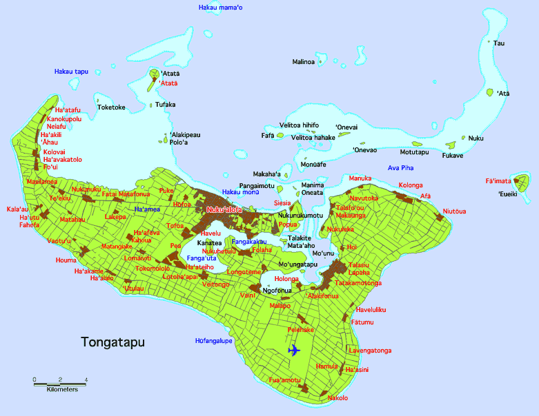
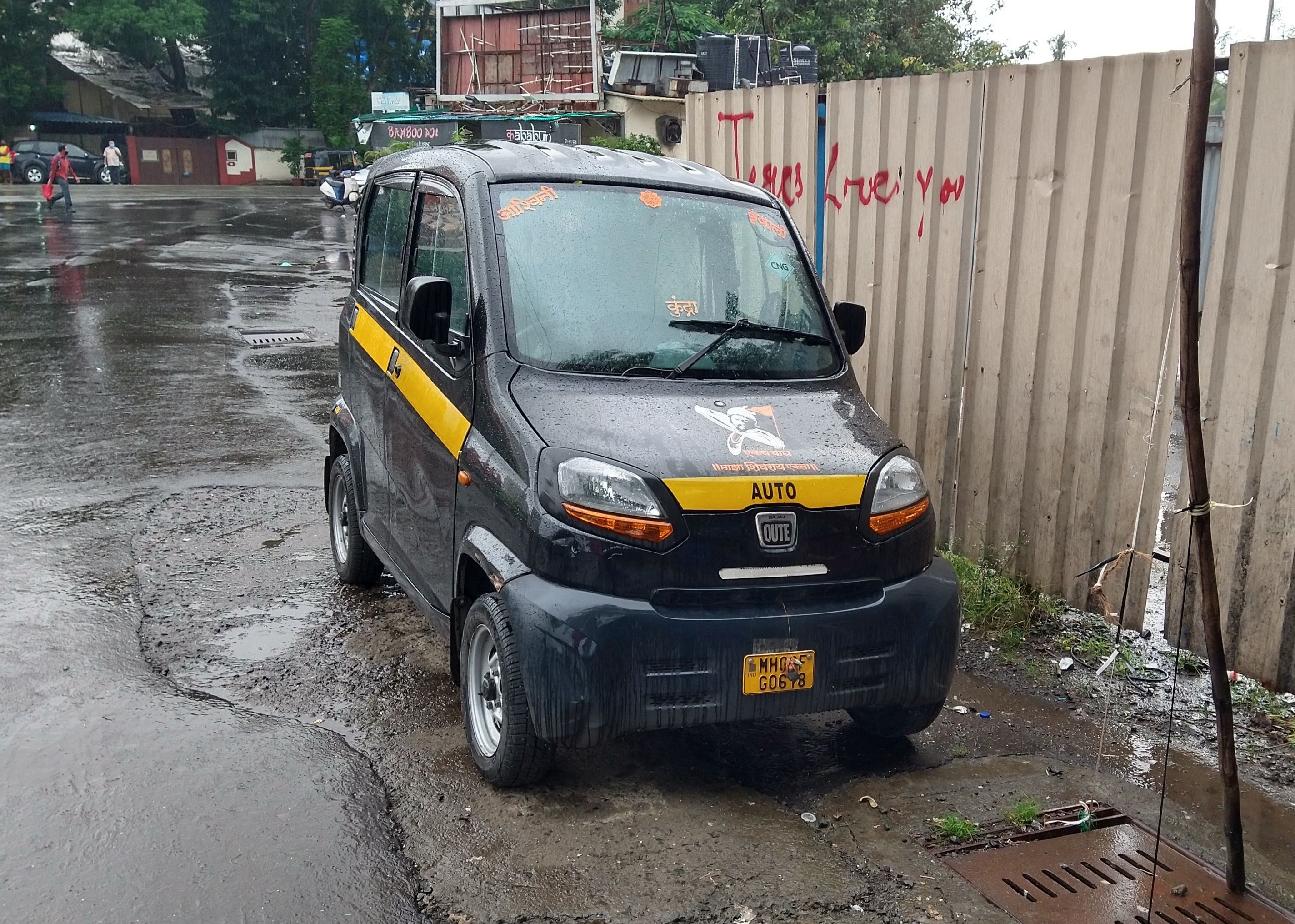
Transport in Tonga includes road, air and water-based infrastructure. There are 680 km of highways in Tonga, of which 184 km are paved, and there are a number of air and seaports. There are three harbours in Tonga: Neiafu, Nukualofa and Pangai, and in terms of merchant marine, the country possesses seven ships that exceed 1,000 GT, whose masses combined total 17,760GT. By type, there is one bulk ship, two cargo ships, two liquefied gas ships, one petroleum tanker and roll-on/roll-off ship, the MV ‘Otuanga’ofa. By 1999 estimates, there are six airports in Tonga. Of these, only Fuaamotu International Airport on Tongatapu has paved runways. Of the remaining airports, one has runways exceeding length 1,524 m, two have runways longer than 914 m, with the remaining two having runways shorter than 914 m. There was formerly a railway in Nuku'alofa, but it no longer exists. Currently, Bajaj RE and Bajaj Qute are used in Nuku'alofa as taxi A taxi, also known as a ... [...More Info...] [...Related Items...] OR: [Wikipedia] [Google] [Baidu] |
Highway
A highway is any public or private road or other public way on land. It is used for major roads, but also includes other public roads and public tracks. In some areas of the United States, it is used as an equivalent term to controlled-access highway, or a translation for ''autobahn'', '' autoroute'', etc. According to Merriam Webster, the use of the term predates the 12th century. According to Etymonline, "high" is in the sense of "main". In North American and Australian English, major roads such as controlled-access highways or arterial roads are often state highways (Canada: provincial highways). Other roads may be designated " county highways" in the US and Ontario. These classifications refer to the level of government (state, provincial, county) that maintains the roadway. In British English, "highway" is primarily a legal term. Everyday use normally implies roads, while the legal use covers any route or path with a public right of access, including footpaths et ... [...More Info...] [...Related Items...] OR: [Wikipedia] [Google] [Baidu] |
Harbour
A harbor (American English), harbour (British English; see spelling differences), or haven is a sheltered body of water where ships, boats, and barges can be docked. The term ''harbor'' is often used interchangeably with ''port'', which is a man-made facility built for loading and unloading vessels and dropping off and picking up passengers. Ports usually include one or more harbors. Alexandria Port in Egypt is an example of a port with two harbors. Harbors may be natural or artificial. An artificial harbor can have deliberately constructed breakwaters, sea walls, or jettys or they can be constructed by dredging, which requires maintenance by further periodic dredging. An example of an artificial harbor is Long Beach Harbor, California, United States, which was an array of salt marshes and tidal flats too shallow for modern merchant ships before it was first dredged in the early 20th century. In contrast, a natural harbor is surrounded on several sides of land. Example ... [...More Info...] [...Related Items...] OR: [Wikipedia] [Google] [Baidu] |
Neiafu (Vava'u) – a village on Savai'i island.
{{disambig ...
Neiafu is the name of several places in Polynesia: Tonga * Neiafu (Vava'u) – the second largest town in Tonga, located on Vava'u island. * Neiafu (Tongatapu) – a small village at the western end of Tongatapu island. Samoa *Neiafu (Samoa) Neiafu is a village on the island of Savai'i in Samoa. It is in the Alataua Sisifo electoral district and located at the south west corner of the island. The population of Neiafu Uta is 601 and Neiafu Tai is 307. Like many villages in Samoa, Nei ... [...More Info...] [...Related Items...] OR: [Wikipedia] [Google] [Baidu] |
Nukuʻalofa
Nukualofa (; ) is the capital and largest city of Tonga. It is located on the north coast of the island of Tongatapu, in the country's southernmost island group. History First western records of Nukualofa On 10 June 1777, British captain James Cook wrote of his arrival at their anchorage place. His description of the place confirmed, with his map, that this was the bay of Nukualofa. Cook never used the name Nukualofa or any other spelling for the reports of this voyage, but he mentioned the island of Pangaimodoo ( Pangaimotu) which was to the east of his anchorage position. Captain Cook also wrote that he travelled by canoes to visit Mooa ( Mua) where Paulaho and other great men lived. The house that Paulaho provided was on the beach from the ship. Reference to his map shows that he must have landed and stayed in the Siesia area, the eastern part of modern Nukualofa. Cook also drafted the first map of the bay of Nukuʻalofa. The first written record for Nukuʻalofa is s ... [...More Info...] [...Related Items...] OR: [Wikipedia] [Google] [Baidu] |
Pangai
Pangai is the administrative capital village of the Haapai Group in Tonga. Town The village is on the western shore of Lifuka and has a population of 1,026. The village center is around the Catholic Church (''Siasi Katolika'')Ha'apai Pictures - Siasi Church, Pangai Village, Lifuka and Holopeka Road by the harbor. There are only a few shops and markets and one bank. There are few historic sites besides some churches, a few d houses and cemeteries. [...More Info...] [...Related Items...] OR: [Wikipedia] [Google] [Baidu] |
Roll-on/roll-off
Roll-on/roll-off (RORO or ro-ro) ships are cargo ships designed to carry wheeled cargo, such as cars, motorcycles, trucks, semi-trailer trucks, buses, Trailer (vehicle), trailers, and railroad cars, that are driven on and off the ship on their own wheels or using a platform vehicle, such as a self-propelled modular transporter. This is in contrast to lift-on/lift-off (LoLo) vessels, which use a crane (machine), crane to load and unload cargo. RORO vessels have either built-in or shore-based Linkspan, ramps or ferry slips that allow the cargo to be efficiently rolled on and off the vessel when in port. While smaller ferries that operate across rivers and other short distances often have built-in ramps, the term RORO is generally reserved for large oceangoing vessels. The ramps and doors may be located in the stern, Bow (ship), bow, or sides, or any combination thereof. Description Types of RORO vessels include ferry, ferries, cruiseferry, cruiseferries, cargo ships, barges, an ... [...More Info...] [...Related Items...] OR: [Wikipedia] [Google] [Baidu] |
MV ‘Otuanga’ofa
MV ''ʻOtu Angaʻofa'' ("friendly islands") is an inter-island ferry which has operated in Tonga since 2010. It replaced . The ship was built in Japan and was paid for by the Japanese government at a cost of US$16 million. It arrived in Tonga in October 2010, and after a period of testing, entered service with the Friendly Island Shipping Agency in December 2010. It normally operates between Nukuʻalofa, Pangai, and Neiafu. In January 2012 it collided with a stationary vessel twice at Nukuʻalofa while trying to dock. No injuries were reported, but $50,000 of damage was caused to the . In May 2014 it ran aground at Niuatoputapu. In July 2014 it was sent to Fiji Fiji ( , ,; fj, Viti, ; Fiji Hindi: फ़िजी, ''Fijī''), officially the Republic of Fiji, is an island country in Melanesia, part of Oceania in the South Pacific Ocean. It lies about north-northeast of New Zealand. Fiji consists ... for maintenance after cracks were found inside a ballast tank. In J ... [...More Info...] [...Related Items...] OR: [Wikipedia] [Google] [Baidu] |
Fuaʻamotu International Airport
Fuaamotu International Airport is an international airport in Tonga. It is on the south side of the main island, Tongatapu, 20 km from the capital of Tonga, Nukualofa. Although named after the nearby village of Fuaʻamotu, which is on Tungī's (the king's) estate, in reality the airfield is located on the Tui Pelehake's estate, closer to the village of Pelehake (which did not yet exist as a village during the early aviation days). The air field was constructed by Seabees of the 1st Construction Battalion with assistance and labor of the U. S. Army 147th Infantry Regiment. It was intended as a World War II heavy bomber field, and had three coral-surfaced runways. In the late 1970s, it was expanded to permit jet aircraft to use the runways. Fuaamotu is now suitable for up to Boeing 767 size aircraft, but remains closed to larger jets (e.g. Boeing 747s). Fuaamotu International Airport is equipped with VOR/DME (114.5) and NDB (245) navigational facilities. No ILS is availa ... [...More Info...] [...Related Items...] OR: [Wikipedia] [Google] [Baidu] |
Tongatapu
Tongatapu is the main island of Tonga and the site of its capital, Nukualofa. It is located in Tonga's southern island group, to which it gives its name, and is the country's most populous island, with 74,611 residents (2016), 70.5% of the national population, on . Based on Google Earth Pro, its maximum elevation is at least above sea level along Liku Road at 21 degrees 15 minutes and 55.7 seconds south 175 degrees 08 minutes 06.4 seconds west, but could be even higher somewhere else. Tongatapu is Tonga's centre of government and the seat of its monarchy. Tongatapu has experienced more rapid economic development than the other islands of Tonga, and has thus attracted many internal migrants from them. Geography The island is (or including neighbouring islands) and rather flat, as it is built of coral limestone. The island is covered with thick fertile soil consisting of volcanic ash from neighbouring volcanoes. At the steep coast of the south, heights reach an average of , an ... [...More Info...] [...Related Items...] OR: [Wikipedia] [Google] [Baidu] |
Bajaj Qute
The Bajaj Qute, earlier called Bajaj RE60, is a rear-engine, rear-wheel-drive, four-passenger quadricycle built by the Indian company Bajaj Auto and is aimed primarily at the Indian domestic market. The car was the first four-wheeler manufactured by Bajaj Auto, which was unveiled on 3 January 2012. In India, the Qute is not legally classified as a car. On 22 May 2013, The Central Government legally classified it as a quadricycle. It is unable to reach speeds of 90 km/h and is therefore only allowed to be used for commercial purposes to replace auto rickshaws. History In 2010, Bajaj Auto announced the cooperation with Renault and Nissan Motor to develop of a US$2,500 car, aiming at a fuel-efficiency of (3.3 L/100 km), or twice an average small car, and carbon dioxide emissions of 100 g/km. Bajaj Auto first unveiled the Bajaj Qute as the RE60 on 3 January 2012, at the 2012 Auto Expo in Delhi. Bajaj Auto was best known for scooters and three-wheel auto-ricksha ... [...More Info...] [...Related Items...] OR: [Wikipedia] [Google] [Baidu] |
.jpg)


