|
Såtbakkollen
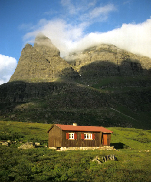
Såtbakkollen is a tall mountain in Sunndal Municipality in Møre og Romsdal county, Norway. It is located in the Trollheimen mountain range, just north of the Sunndalen valley. It forms the southern end of the "Tårn massif", which also includes Tåga, Tårnfjellet, and the quite famous Innerdalstårnet. Other mountains nearby include Navardalsnebba, Trolla, and Skarfjellet Skarfjellet is a tall mountain in Sunndal Municipality in Møre og Romsdal county, Norway. It lies along the southern side of the Innerdalen valley, just west of the mountain Innerdalstårnet, and about northeast of the village of Sunndalsøra .... The name "Såtbakkollen" is also commonly used for the peak Tåga (elevation: , prominence: ; second highest point in Trollheimen). Tåga is actually located about further north, probably because the name "Tåga" was missing from older maps. References Mountains of Møre og Romsdal Sunndal {{MøreRomsdal-geo-stub ... [...More Info...] [...Related Items...] OR: [Wikipedia] [Google] [Baidu] |
Trollheimen
Trollheimen is a mountain range in Møre og Romsdal and Trøndelag counties in central Norway. The mountain range is part of the Scandinavian Mountains. Etymology The name ('the home of the trolls') was proposed by Håkon Løken and used by Trondhjems Turistforening in the 1880s, and is considered a "tourist name" (there was no single name for the entire area before). Trollheimen is now the common name in Norway for this mountain range. Topography and climate Trollheimen is often considered the most varied of all mountain ranges in Norway for several reasons. The mountains in the western part are alpine in form, with pointed peaks and typical river valleys. The mountains in the east are less steep with more rounded shapes predominating, and the valleys are wider and bear the mark of being created by glaciers. The climate differs from the more oceanic climate in the west to a considerably drier, continental climate in the eastern valleys, due to their being sheltered by mount ... [...More Info...] [...Related Items...] OR: [Wikipedia] [Google] [Baidu] |
Innerdalstårnet
Innerdalstårnet or Dalatårnet is a tall mountain on the south side of the Innerdalen valley in Sunndal Municipality in Møre og Romsdal county, Norway. It is located about southeast of the village of Ålvundeid. The mountain is also known as the ''Matterhorn of Norway'' for its characteristic pyramidal shape. The summit can be reached with some scrambling, and the mountain is a very popular destination for rock climbing, several routes are established up the mountain.Klatrefører for Innerdalen, Norsk Tindeklubb The northern sub-peak, Litle Innerdalstårnet (seen in the picture) is slightly more inaccessible. Directly south of Innerdalstårnet are the mountains Tårnfjellet and Såtbakkollen, which is the second highest in Trollheimen Trollheimen is a mountain range in Møre og Romsdal and Trøndelag counties in central Norway. The mountain range is part of the Scandinavian Mountains. Etymology The name ('the home of the trolls') was proposed by Håkon Løken and u ... [...More Info...] [...Related Items...] OR: [Wikipedia] [Google] [Baidu] |
Sunndal Municipality
is a municipality in the Nordmøre region located in the northeast part of Møre og Romsdal county, Norway. The administrative center of the municipality is the village of Sunndalsøra. Other villages include Gjøra, Grøa, Hoelsand, Jordalsgrenda, Romfo, Ålvund, Ålvundeidet, and Øksendalsøra. With an area of , it is the largest municipality in Møre og Romsdal county. The important occupations in Sunndal include industry (with Hydro Aluminium Sunndal as the biggest employer), public services, retail, and farming. The municipality is the 47th largest by area out of the 356 municipalities in Norway and it is the largest in Møre og Romsdal county. Sunndal is the 143rd most populous municipality in Norway with a population of 6,932. The municipality's population density is and its population has decreased by 3.7% over the previous 10-year period. General information The parish of Sunndal was established as a municipality on 1 January 1838 (see formannskapsdistrikt law) ... [...More Info...] [...Related Items...] OR: [Wikipedia] [Google] [Baidu] |
Vassnebba
Vassnebba or Grånebba is a mountain on the border of the municipalities of Sunndal and Surnadal in Møre og Romsdal county, Norway. It lies on the western border of the Trollheimen mountain range, just southwest of the Todalsfjorden and the village of Todalsøra and southeast of the village of Ålvund. The mountain is easily accessed from both sides, summer and winter. Name The mountain has two different names. People from Todalsøra, in the valley to the east of the mountain, call it ''Vassnebba'', while people on the western side, Ålvundeid Ålvundeid is a former municipality in Møre og Romsdal county, Norway. The municipality existed from 1899 until its dissolution in 1960. It had one of the smallest municipal populations in Norway. It was located in the northern part of the p ..., use the name ''Grånebba''. References Mountains of Møre og Romsdal Sunndal Surnadal {{MøreRomsdal-geo-stub ... [...More Info...] [...Related Items...] OR: [Wikipedia] [Google] [Baidu] |
Møre Og Romsdal
Møre og Romsdal (; en, Møre and Romsdal) is a county in the northernmost part of Western Norway. It borders the counties of Trøndelag, Innlandet, and Vestland. The county administration is located in the town of Molde, while Ålesund is the largest town. The county is governed by the Møre og Romsdal County Municipality which includes an elected county council and a county mayor. The national government is represented by the county governor. Name The name ''Møre og Romsdal'' was created in 1936. The first element refers to the districts of Nordmøre and Sunnmøre, and the last element refers to Romsdal. Until 1919, the county was called "Romsdalens amt", and from 1919 to 1935 "Møre fylke". For hundreds of years (1660-1919), the region was called ''Romsdalen amt'', after the Romsdalen valley in the present-day Rauma Municipality. The Old Norse form of the name was ''Raumsdalr''. The first element is the genitive case of the name ''Raumr'' derived from the nam ... [...More Info...] [...Related Items...] OR: [Wikipedia] [Google] [Baidu] |
Norway
Norway, officially the Kingdom of Norway, is a Nordic country in Northern Europe, the mainland territory of which comprises the western and northernmost portion of the Scandinavian Peninsula. The remote Arctic island of Jan Mayen and the archipelago of Svalbard also form part of Norway. Bouvet Island, located in the Subantarctic, is a dependency of Norway; it also lays claims to the Antarctic territories of Peter I Island and Queen Maud Land. The capital and largest city in Norway is Oslo. Norway has a total area of and had a population of 5,425,270 in January 2022. The country shares a long eastern border with Sweden at a length of . It is bordered by Finland and Russia to the northeast and the Skagerrak strait to the south, on the other side of which are Denmark and the United Kingdom. Norway has an extensive coastline, facing the North Atlantic Ocean and the Barents Sea. The maritime influence dominates Norway's climate, with mild lowland temperatures on the ... [...More Info...] [...Related Items...] OR: [Wikipedia] [Google] [Baidu] |
Scrambling
Scrambling is a mountaineering term for ascending steep terrain using one's hands to assist in holds and balance.''New Oxford American Dictionary''. It is also used to describe terrain that falls between hiking and rock climbing (as a “scramble”). Sure-footedness and a head for heights are essential. Canyoning and stream climbing are other types of scrambling. Overview Scrambling is ascending or traversing a grade without technical apparatus. Unroped ascent in exposed situations is potentially one of the most dangerous of mountaineering activities. As soon as an ascent involves a rope, going up or down, it is no longer a scramble. Alpine scrambling Alpine scrambling is scrambling in high mountains and may not follow a defined or waymarked path. The Seattle Mountaineers climbing organization defines alpine scrambling as follows: Alpine Scrambles are off-trail trips, often on snow or rock, with a 'non-technical' summit as a destination. A non-technical summit is ... [...More Info...] [...Related Items...] OR: [Wikipedia] [Google] [Baidu] |
Trolla
Trolla is a village in the municipality of Trondheim in Trøndelag county, Norway. It is located in the Midtbyen borough, along the Trondheimsfjord on the north coast of the Bymarka area. It is about northeast of the village of Langørjan Langørjan or Rye is a village in the municipality of Trondheim in Trøndelag county, Norway. The village is located in the borough of Heimdal in the Byneset district about west of the city of Trondheim and about north of the village of Spongda ... and about northwest of the Ila neighborhood in the city of Trondheim. The village has a population (2018) of 549 and a population density of . References Geography of Trondheim Villages in Trøndelag {{Trøndelag-geo-stub ... [...More Info...] [...Related Items...] OR: [Wikipedia] [Google] [Baidu] |


