|
Sunda Megathrust
The Sunda megathrust is a fault (geology), fault that extends approximately 5,500 km (3300 mi) from Burma, Myanmar (Burma) in the north, running along the southwestern side of Sumatra, to the south of Java and Bali before terminating near Australia. It is a megathrust, located at a Convergent boundary, convergent plate boundary where it forms the interface between the overriding Eurasian plate and the Subduction, subducting Indo-Australian plate. It is one of the most seismogenic structures on Earth, being responsible for many great and giant earthquakes, including the 2004 Indian Ocean earthquake and tsunami that killed over 227,000 people. The Sunda megathrust can be divided into the ''Andaman Megathrust'', ''Sumatra(n) Megathrust'' and ''Java(n) Megathrust''. The Bali-Sumbawa segment is much less active and therefore does not have the "megathrust" term associated with it. Tectonic setting The subducting plate consists of two protoplates, the Indian Plate, Indian a ... [...More Info...] [...Related Items...] OR: [Wikipedia] [Google] [Baidu] |
Indian Plate
The Indian Plate (or India Plate) is a minor tectonic plate straddling the equator in the Eastern Hemisphere. Originally a part of the ancient continent of Gondwana, the Indian Plate broke away from the other fragments of Gondwana , began moving north and carried Insular India with it. It was once fused with the adjacent Australian Plate to form a single Indo-Australian Plate, and recent studies suggest that India and Australia have been separate plates for at least 3 million years and likely longer. The Indian Plate includes most of modern South Asia (the Indian subcontinent) and a portion of the basin under the Indian Ocean, including parts of South China and western Indonesia, and extending up to but not including Ladakh, Kohistan and Balochistan. Plate movements Until roughly , the Indian Plate formed part of the supercontinent Gondwana together with modern Africa, Australia, Antarctica, and South America. Gondwana broke up as these continents drifted apart at different ... [...More Info...] [...Related Items...] OR: [Wikipedia] [Google] [Baidu] |
1935 Sumatra Earthquake
The 1935 Sumatra earthquake occurred at on 28 December. It had a magnitude of 7.7 and a maximum felt intensity of VIII (''Severe'') on the Mercalli intensity scale. It triggered a minor tsunami. Tectonic setting The island of Sumatra lies on the convergent plate boundary between the Indo-Australian Plate and the Eurasian Plate. The convergence between these plates is highly oblique near Sumatra, with the displacement being accommodated by near pure dip-slip faulting along the subduction zone, known as the Sunda megathrust, and near pure strike-slip faulting along the Great Sumatran fault. The major slip events on the subduction zone interface are typically of megathrust type. Historically, great or giant megathrust earthquakes have been recorded in 1797, 1833, 1861, 2004, 2005 and 2007, most of them being associated with devastating tsunamis. Smaller (but still large) megathrust events have also occurred in the small gaps between the areas that slip during the larger event ... [...More Info...] [...Related Items...] OR: [Wikipedia] [Google] [Baidu] |
September 2007 Sumatra Earthquake
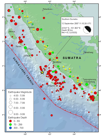
The September 2007 Sumatra earthquakes were a series of megathrust earthquakes that struck the Sunda Trench off the coast of Sumatra, Indonesia, with three of magnitude 7 or greater. A series of tsunami bulletins was issued for the area. The most powerful of the series had a magnitude of 8.5, which makes it in the top 20 of the largest earthquakes ever recorded on a seismograph. Timeline The first earthquake occurred at 11:10:26 UTC (18:10 local time) on 12 September 2007, and was an 8.5 earthquake on the moment magnitude scale. It had a focal depth of 34 km, at , about 130 km southwest of Bengkulu on the southwest coast of Sumatra, Indonesia, and some 600 km west-northwest of Indonesia's capital city, Jakarta. It was followed by several earthquakes of magnitude 5 through 6 along the same fault, west of Sumatra. The second largest earthquake, 7.9 Mw, occurred later the same day at 23:49:04 UTC (06:49:04 local time the following day). It was centred ... [...More Info...] [...Related Items...] OR: [Wikipedia] [Google] [Baidu] |
2005 Nias–Simeulue Earthquake
The 2005 Nias–Simeulue earthquake occurred on 28 March off the west coast of northern Sumatra, Indonesia. At least 915 people were killed, mostly on the island of Nias. The event caused panic in the region, which had already been devastated by the massive tsunami triggered by the 2004 Indian Ocean earthquake, but this earthquake generated a relatively small tsunami that caused limited damage. It was the third most powerful earthquake since 1965 in Indonesia. The earthquake occurred at 16:09:37 UTC (23:09:37 local time) on 28 March 2005. The hypocenter was located below the surface of the Indian Ocean, where subduction is forcing the Indo-Australian Plate to the southwest under the Eurasian Plate's Sunda edge. The area is west of Sibolga, Sumatra, or northwest of Jakarta, approximately halfway between the islands of Nias and Simeulue. Seismic recordings give the earthquake a moment magnitude of about 8.6, and effects were felt as far away as Bangkok, Thailand, over away. Ea ... [...More Info...] [...Related Items...] OR: [Wikipedia] [Google] [Baidu] |
1861 Sumatra Earthquake
Statistically, this year is considered the end of the whale oil industry and (in replacement) the beginning of the petroleum oil industry. Events January–March * January 1 ** Benito Juárez captures Mexico City. ** The first steam-powered carousel is recorded, in Bolton, England. * January 2 – Friedrich Wilhelm IV of Prussia dies, and is succeeded by Wilhelm I. * January 3 – American Civil War: Delaware votes not to secede from the Union. * January 9 – American Civil War: Mississippi becomes the second state to secede from the Union. * January 10 – American Civil War: Florida secedes from the Union. * January 11 – American Civil War: Alabama secedes from the Union. * January 12 – American Civil War: Major Robert Anderson sends dispatches to Washington. * January 19 – American Civil War: Georgia secedes from the Union. * January 21 – American Civil War: Jefferson Davis resigns from the United States Senate. * Janua ... [...More Info...] [...Related Items...] OR: [Wikipedia] [Google] [Baidu] |
1833 Sumatra Earthquake
The 1833 Sumatra earthquake occurred on November 25 at about 22:00 local time, with an estimated magnitude in the range of 8.8–9.2 . It caused a large tsunami that flooded the southwestern coast of the island. There are no reliable records of the loss of life, with the casualties being described only as 'numerous'. The magnitude of this event has been estimated using records of uplift taken from coral microatolls. Background The island of Sumatra lies on the convergent plate boundary between the Indo-Australian Plate and the Eurasian Plate. The convergence between these plates is highly oblique near Sumatra, with the displacement being accommodated by near pure dip-slip faulting along the subduction zone, known as the Sunda megathrust, and near pure strike-slip faulting along the Great Sumatran fault. The major slip events on the subduction zone interface are typically of megathrust type. Historically, great or giant megathrust earthquakes have been recorded in 1797, 1833, 1861 ... [...More Info...] [...Related Items...] OR: [Wikipedia] [Google] [Baidu] |
1797 Sumatra Earthquake
The 1797 Sumatra earthquake occurred at 22:00 local time on February 10. It was the first in a series of great earthquakes that ruptured part of the Sumatran segment of the Sunda megathrust. It caused a damaging tsunami that was particularly severe near Padang, where a 150–200 ton English ship was driven 1 km inland up the Arau River. Background The island of Sumatra lies on the convergent plate boundary between the Indo-Australian Plate and the Eurasian Plate. The convergence between these plates is highly oblique near Sumatra, with the displacement being accommodated by near pure dip-slip faulting along the subduction zone, known as the Sunda megathrust, and near pure strike-slip faulting along the Great Sumatran fault. The major slip events on the subduction zone interface are typically of the megathrust type. Historically, great or giant megathrust earthquakes have been recorded in 1797, 1833, 1861, 2004, 2005 and 2007, most of them being associated with devastating ... [...More Info...] [...Related Items...] OR: [Wikipedia] [Google] [Baidu] |
Historical Earthquakes
Historical earthquakes is a list of significant earthquakes known to have occurred prior to the beginning of the 20th century. As the events listed here occurred before routine instrumental recordings, they rely mainly on the analysis of written sources. There is often significant uncertainty in location and magnitude and sometimes date for each earthquake. The number of fatalities is also often highly uncertain, particularly for the older events. Pre-11th century 11th–18th centuries 19th century Source for all events with 'USGS' labelled as the source United States Geological Survey (USGS''Note: Magnitudes are generally estimations from intensity data. When no magnitude was available, the Mercalli intensity scale, maximum intensity, written as a Roman numeral from I to XII, is given.'' See also * :Articles on pre-1900 earthquakes * List of 20th-century earthquakes * List of 21st-century earthquakes * List of tsunamis * Lists of earthquakes * List of megathrust ear ... [...More Info...] [...Related Items...] OR: [Wikipedia] [Google] [Baidu] |
USGS Sunda Trench
The United States Geological Survey (USGS), formerly simply known as the Geological Survey, is a scientific agency of the United States government. The scientists of the USGS study the landscape of the United States, its natural resources, and the natural hazards that threaten it. The organization's work spans the disciplines of biology, geography, geology, and hydrology. The USGS is a fact-finding research organization with no regulatory responsibility. The agency was founded on March 3, 1879. The USGS is a bureau of the United States Department of the Interior; it is that department's sole scientific agency. The USGS employs approximately 8,670 people and is headquartered in Reston, Virginia. The USGS also has major offices near Lakewood, Colorado, at the Denver Federal Center, and Menlo Park, California. The current motto of the USGS, in use since August 1997, is "science for a changing world". The agency's previous slogan, adopted on the occasion of its hundredth anniversa ... [...More Info...] [...Related Items...] OR: [Wikipedia] [Google] [Baidu] |
Mentawai Islands
Mentawai may refer to: * Mentawai Islands * Mentawai Strait * Mentawai people * Mentawai language The Mentawai language is an Austronesian language, spoken by the Mentawai people of the Mentawai Islands, West Sumatra, Indonesia. Dialects According to ''Ethnologue'', Mentawai dialects include: Silabu, Sipura – Simalegi, Sakalagan, S ... {{dab Language and nationality disambiguation pages ... [...More Info...] [...Related Items...] OR: [Wikipedia] [Google] [Baidu] |
Great Sumatran Fault
The Indonesian island of Sumatra is located in a highly seismic area of the world. In addition to the subduction, subduction zone off the west coast of the island, Sumatra also has a large Fault (geology)#Strike-slip faults, strike-slip fault, the Great Sumatran Fault also known as Semangko Fault, running the entire length of the island. This fault zone accommodates most of the strike-slip motion associated with the oblique convergence between the Indo-Australian Plate, Indo-Australian and Eurasian plate, Eurasian Plate tectonics, plates. The fault ends in the north just below the city of Banda Aceh, which was devastated in the 2004 Indian Ocean earthquake. After the December 2004 earthquake, pressure on the Great Sumatran Fault has increased tremendously, especially in the north. Geologic significance The Great Sumatran Fault is part of the system where strain partitioning was first described in plate tectonics. The convergence between the Indo-Australian Plate and the Sunda Plat ... [...More Info...] [...Related Items...] OR: [Wikipedia] [Google] [Baidu] |


