|
Suisunes
The Suisunes (also called the Suisun and the "People of the West Wind") were a Patwin tribe of Wintun people, originating in the Suisin Bay and Suisun Marsh regions of Solano County in Northern California. Their traditional homelands stretched between what is now Suisun City, Vacaville and Putah Creek around 200 years ago. The Suisunes' main village, Yulyul, is believed to be where Rockville, California is located today. Father Abella, visitor to the tribe in 1811, indicated they resided in the present location of Fairfield, north of the Suisun Bay.Milliken 1995:255. One of the Suisunes' primary food sources was acorns. Their diet also included fish as well as miner's lettuce. Their huts (as recorded by the Spaniards in 1817) were conical wikiups made of rushes or tule thatch. History The Suisunes were one tribe of the Patwin Indians, who were the southern branch of the Wintun group, who had lived in the region for up to 4000 years. Few records have been handed down; approxim ... [...More Info...] [...Related Items...] OR: [Wikipedia] [Google] [Baidu] |
Chief Solano (Namesake Of Solano County, California)
Sem-Yeto () was a leader of the Suisunes, a Patwin people of the Suisun Bay region of northern California. Baptized as Francisco Solano and also known as Chief Solano, he was a notable Native American leader in Alta California because of his alliance, friendship, and eventually the support of his entire tribe to General Mariano Guadalupe Vallejo of Sonoma, in military and political excursions around Sonoma County and the San Francisco Bay Area. By allying with Vallejo and assisting him in quelling Native American uprisings north and west of Sonoma between 1836 and 1843, Sem-Yeto is regarded as a controversial historical figure. The California county of Solano is named for him. Childhood Sem-Yeto, an epithet meaning "brave or fierce hand," was born about 1798–1800 in the Suisun Bay region of California and lived there the first years of his life. On July 24, 1810, he was baptized at the San Francisco Mission and there adopted the baptismal name of the Spanish saint Francis ... [...More Info...] [...Related Items...] OR: [Wikipedia] [Google] [Baidu] |
Patwin
The Patwin (also Patween, Southern Wintu) are a band of Wintun people native to the area of Northern California. The Patwin comprise the southern branch of the Wintun group, native inhabitants of California since approximately 500 AD. The Patwin were bordered by the Yuki in the northwest; the Nomlaki (Wintun) in the north; the Konkow (Maiduan) in northeast; the Nisenan (Maiduan) and Plains Miwok in the east; the Bay Miwok to the south; the Coast Miwok in the southwest; and the Wappo, Lake Miwok, and Pomo in the west. The "Southern Patwins" lived between what is now Suisun, Vacaville, and Putah Creek. By 1800 they had been forced by Spanish and other European settlers into small tribal units: Ululatos (Vacaville), Labaytos (Putah Creek), Malacas (Lagoon Valley), Tolenas (Upper Suisun Valley), and Suisunes (Suisun Marsh and Plain). Patwin Indian remains were discovered at the Mondavi Center construction site beginning in 1999, and consequently the University of California, Davi ... [...More Info...] [...Related Items...] OR: [Wikipedia] [Google] [Baidu] |
Rockville, California
Rockville is a small unincorporated community in northern-central Solano County, California, southwest of Fairfield and closest to Cordelia. Yulyul, the main village of the Suisunes (a Patwin people of the Suisun Bay region), is believed to be where Rockville is located today. The main economic activities are farming, tourism, and the large regional Rockville Cemetery. Tourism Rockville is the home of the Rockville Hills Regional Park Rockville Hills Regional Park is a 633-acre (~256 hectare, 2.56 square kilometer) regional park in the city of Fairfield, Solano County, California, United States. The park is known for its volcanic rocks, thin topsoil, grasses, and blue oak trees. ..., consisting of 633 acres of grasslands and oak woodlands, with a dense mixed broadleaf forest through which there are many hiking and biking trails. References External links Rockville Hills Regional Park on Facebook HistoryArticle 'Preserving the past: Native heritage stands firm in county ... [...More Info...] [...Related Items...] OR: [Wikipedia] [Google] [Baidu] |
Suisun Marsh
Located in northern California, the Suisun Marsh ( ) has been referred to as the largest brackish water marsh on west coast of the United States of America. The marsh land is part of the San Francisco Bay tidal estuary, and subject to tidal ebb and flood. The marsh is home to many species of birds and other wildlife, and is formed by the confluence of the Sacramento and San Joaquin rivers between Martinez and Suisun City, California and several other smaller, local watersheds. Adjacent to Suisun Bay, the marsh is immediately west of the legally defined Sacramento-San Joaquin Delta as well as part of the San Francisco Bay estuary. The Suisun Marsh is named for the Suisunes, a Patwin/Wintun sub-tribe, who inhabited the area around 200 years ago. Overview Suisun Marsh, 116,000 acres (470 km2) of land, bays, and sloughs, is one of the largest estuarine marshes in the western United States. Geologically, the Suisun Marsh is the product of water-borne sediment deposition, carri ... [...More Info...] [...Related Items...] OR: [Wikipedia] [Google] [Baidu] |
Solano County, California
Solano County () is a county located in the U.S. state of California. As of the 2020 census, the population was 453,491. The county seat is Fairfield. Solano County comprises the Vallejo–Fairfield, CA Metropolitan Statistical Area, which is also included in the San Jose–San Francisco–Oakland, CA Combined Statistical Area. Solano County is the northeastern county in the nine-county San Francisco Bay Area region. A portion of the South Campus at the University of California, Davis is in Solano County. History Solano County was one of the original counties of California, created in 1850 at the time of statehood. At the request of General Mariano Guadalupe Vallejo, the county was named for Chief Solano of the Suisun people, a Native American tribe of the region and Vallejo's close ally. Chief Solano at one time led the tribes between the Petaluma River and the Sacramento River. The chief was also called ''Sem-Yeto'', which signifies "brave or fierce hand." The Chief ... [...More Info...] [...Related Items...] OR: [Wikipedia] [Google] [Baidu] |
Fairfield, California
Fairfield is a city in and the county seat of Solano County, California, in the North Bay sub-region of the San Francisco Bay Area. It is generally considered the midpoint between the cities of San Francisco and Sacramento, approximately from the city center of each city, approximately from the city center of Oakland, less than from Napa Valley, from the Carquinez Bridge, and from the Benicia Bridge. Fairfield was founded in 1856 by clippership captain Robert H. Waterman, and named after his former hometown of Fairfield, Connecticut. It is the home of Travis Air Force Base and the headquarters of Jelly Belly. With a population of 119,881 at the 2020 census, it is slightly smaller in population than Vallejo. Other nearby cities include Suisun City, Vacaville, Rio Vista, Benicia, and Napa. Geography According to the United States Census Bureau, the city has a total area of , of which, of it is land and of it is water. The total area is 5.65% water. The city is ... [...More Info...] [...Related Items...] OR: [Wikipedia] [Google] [Baidu] |
Spanish Missions In California
The Spanish missions in California ( es, Misiones españolas en California) comprise a series of 21 religious outposts or missions established between 1769 and 1833 in what is now the U.S. state of California. Founded by Catholic priests of the Franciscan order to evangelize the Native Americans, the missions led to the creation of the New Spain province of Alta California and were part of the expansion of the Spanish Empire into the most northern and western parts of Spanish North America. Following long-term secular and religious policy of Spain in Spanish America, the missionaries forced the native Californians to live in settlements called reductions, disrupting their traditional way of life. The missionaries introduced European fruits, vegetables, cattle, horses, ranching, and technology. Immense reductions in the population of Indigenous peoples of California occurred through the introduction of European diseases, which quickly spread as native people were forced i ... [...More Info...] [...Related Items...] OR: [Wikipedia] [Google] [Baidu] |
Pueblo
In the Southwestern United States, Pueblo (capitalized) refers to the Native tribes of Puebloans having fixed-location communities with permanent buildings which also are called pueblos (lowercased). The Spanish explorers of northern New Spain used the term ''pueblo'' to refer to permanent indigenous towns they found in the region, mainly in New Mexico and parts of Arizona, in the former province of Nuevo México. This term continued to be used to describe the communities housed in apartment structures built of stone, adobe mud, and other local material. The structures were usually multi-storied buildings surrounding an open plaza, with rooms accessible only through ladders raised/lowered by the inhabitants, thus protecting them from break-ins and unwanted guests. Larger pueblos were occupied by hundreds to thousands of Puebloan people. Various federally recognized tribes have traditionally resided in pueblos of such design. Later Pueblo Deco and modern Pueblo Revival architectu ... [...More Info...] [...Related Items...] OR: [Wikipedia] [Google] [Baidu] |
Presidio
A presidio ( en, jail, fortification) was a fortified base established by the Spanish Empire around between 16th century, 16th and 18th century, 18th centuries in areas in condition of their control or influence. The presidios of Captaincy General of the Philippines, Spanish Philippines in particular, were centers where the martial art of Arnis, Arnis de Mano was developed from Spanish cut-and-thrust fencing style. The term is derived from the Latin word ''praesidium'' meaning ''protection'' or ''defense''. In the Mediterranean and the Philippines, the presidios were outposts of Christian defense against Islamic raids. In the Americas, the Fortification, fortresses were built to protect against raid of pirates, rival colonists, as well as Indigenous peoples of the Americas, Native Americans. Later in western North America, with independence, the Mexicans garrisoned the Spanish presidios on the northern frontier and followed the same pattern in unsettled frontier regions such as ... [...More Info...] [...Related Items...] OR: [Wikipedia] [Google] [Baidu] |
Sacramento Valley
, photo =Sacramento Riverfront.jpg , photo_caption= Sacramento , map_image=Map california central valley.jpg , map_caption= The Central Valley of California , location = California, United States , coordinates = , boundaries = Sierra Nevada (east), Cascade Range, Klamath Mountains (north), Coast Range (west), Sacramento–San Joaquin River Delta (south) , towns = Redding, Chico, Yuba City, Sacramento , watercourses = Sacramento River The Sacramento Valley is the area of the Central Valley of the U.S. state of California that lies north of the Sacramento–San Joaquin River Delta and is drained by the Sacramento River. It encompasses all or parts of ten Northern California counties. Although many areas of the Sacramento Valley are rural, it contains several urban areas, including the state capital, Sacramento. Since 2010, statewide droughts in California have further strained both the Sacramento Valley's and the Sacramento metropolitan region's water security. Geog ... [...More Info...] [...Related Items...] OR: [Wikipedia] [Google] [Baidu] |
Carquinez Strait
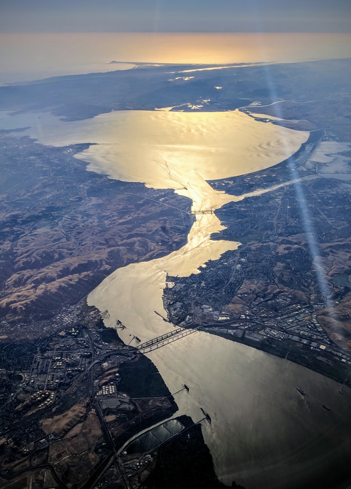
The Carquinez Strait (; Spanish: ''Estrecho de Carquinez'') is a narrow tidal strait in Northern California. It is part of the tidal estuary of the Sacramento and the San Joaquin rivers as they drain into the San Francisco Bay. The strait is long and connects Suisun Bay, which receives the waters of the combined rivers, with San Pablo Bay, a northern extension of the San Francisco Bay. The strait formed in prehistoric times, near the close of one of the past ice ages, when the Central Valley was a vast inland lake. Melting ice from the Sierra Nevada raised the water level while seismic activity created a new outlet to the Pacific Ocean, draining the lake into the ocean and exposing the valley floors. History Andrei Sarna-Wojcicki, a geologist emeritus of the US Geological Survey (USGS), estimates that the Carquinez Strait was likely formed about 640,000 to 700,000 years ago, while much of modern California was emerging from an ice age. The present Sacramento Valley and San J ... [...More Info...] [...Related Items...] OR: [Wikipedia] [Google] [Baidu] |
Mission San Francisco De Asís
Mission San Francisco de Asís ( es, Misión San Francisco de Asís), commonly known as Mission Dolores (as it was founded near the Dolores creek), is a Spanish Californian mission and the oldest surviving structure in San Francisco. Located in the Mission District, it was founded on October 9, 1776, by Padre Francisco Palóu (a companion of Junípero Serra) and co-founder Fray Pedro Benito Cambón, who had been charged with bringing Spanish settlers to Alta California and with evangelizing the local indigenous Californians, the Ohlone. The present mission building was the second structure for the site and was dedicated in 1791. Next to the old mission is the Mission Dolores Basilica, built in 1918 in an elaborate California Churrigueresque style. This larger church replaced a brick parish of 1876, which had been destroyed in the San Francisco earthquake of 1906. The elaborate church was raised to the dignity of a Catholic basilica by Pope Pius XII in 1952. History The sett ... [...More Info...] [...Related Items...] OR: [Wikipedia] [Google] [Baidu] |
.jpg)


