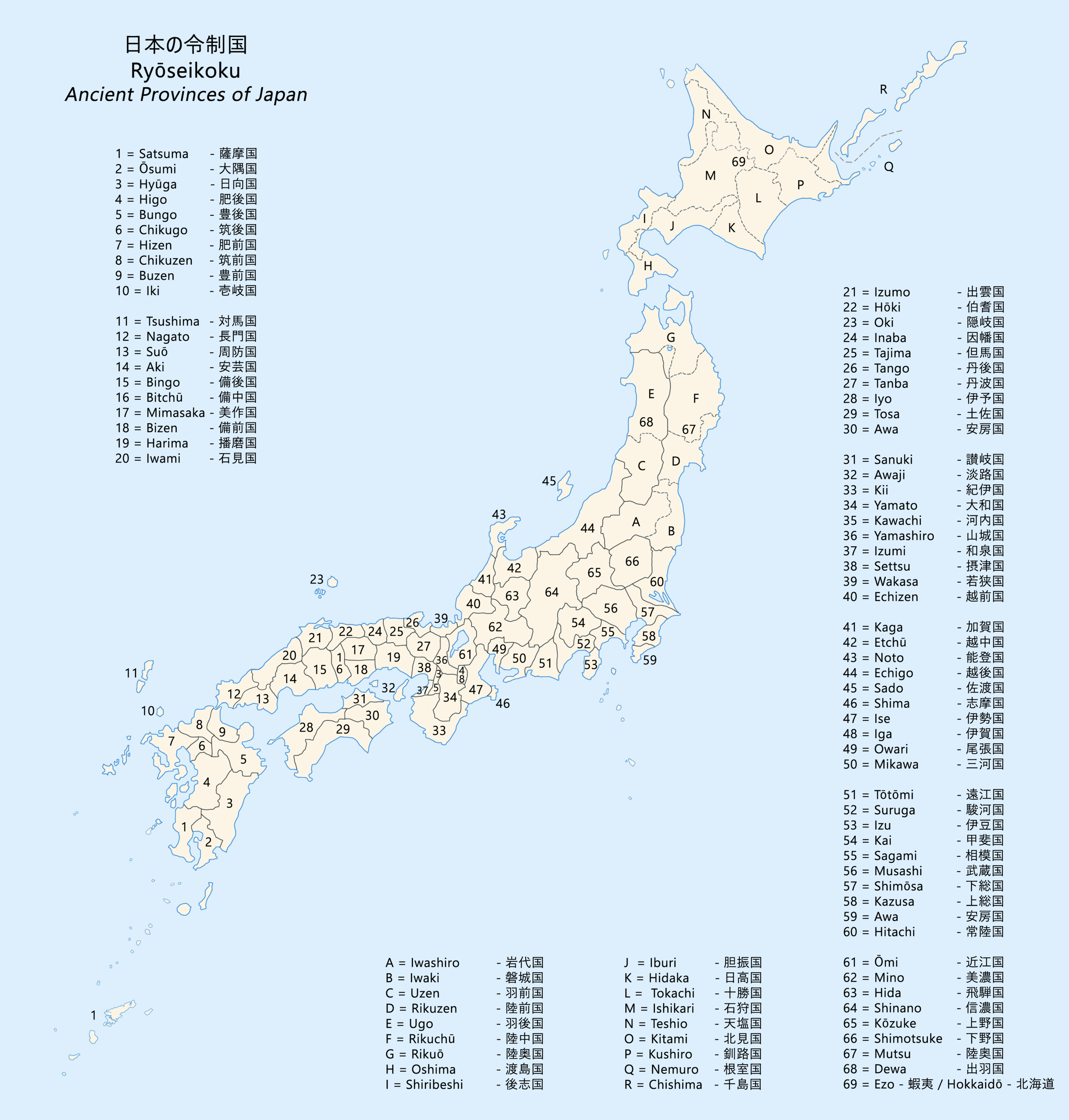
|
Sugito, Saitama
is a town located in Saitama Prefecture, Japan. , the town had an estimated population of 44,402 in 19,409 households and a population density of 1500 persons per km². The total area of the town is . Geography Sugito is located in far eastern Saitama Prefecture, in the middle of the Kantō Plain, with an average altitude of 15 meters above sea level. The Edo River flows through the town. Surrounding municipalities Saitama Prefecture * Kasukabe * Kuki * Satte * Miyashiro Chiba Prefecture * Noda Climate Sugito has a humid subtropical climate (Köppen ''Cfa'') characterized by warm summers and cool winters with light to no snowfall. The average annual temperature in Sugito is 14.5 °C. The average annual rainfall is 1408 mm with September as the wettest month. The temperatures are highest on average in August, at around 26.3 °C, and lowest in January, at around 2.8 °C. Demographics Per Japanese census data, the population of Sugito peaked around the yea ... [...More Info...] [...Related Items...] OR: [Wikipedia] [Google] [Baidu] |
Towns Of Japan
A town (町; ''chō'' or ''machi'') is a local administrative unit in Japan. It is a local public body along with prefecture (''ken'' or other equivalents), city (''shi''), and village (''mura''). Geographically, a town is contained within a district. Note that the same word (町; ''machi'' or ''chō'') is also used in names of smaller regions, usually a part of a ward in a city. This is a legacy of when smaller towns were formed on the outskirts of a city, only to eventually merge into it. Towns See also * Municipalities of Japan * Japanese addressing system The Japanese addressing system is used to identify a specific location in Japan. When written in Japanese characters, addresses start with the largest geographical entity and proceed to the most specific one. When written in Latin characters, ad ... References {{reflist External links "Large_City_System_of_Japan";_graphic_shows_towns_compared_with_other_Japanese_city_types_at_p._1_[PDF_7_of_40/nowiki>">DF_7_of_4 ... [...More Info...] [...Related Items...] OR: [Wikipedia] [Google] [Baidu] |
Kasukabe, Saitama
is a special city located in Saitama Prefecture, Japan. , the city had an estimated population of 233,278 in 108,328 households and a population density of . The total area of the city is . Kasukabe is famous for the production of , traditional ''tansu'' dressers made from paulownia wood. The cultural and economic value of the paulownia is reflected in its designation as the official town tree. Geography Kasukabe is located in far eastern Saitama Prefecture, divided between the Shimosa Plateau and the Omiya Plateau by the Nakagawa lowlands and the Edogawa River. The eastern portion of the city is still rural, with the largest area of paddy fields in Saitama. Surrounding municipalities * Saitama Prefecture ** Koshigaya ** Saitama ** Shiraoka ** Miyashiro ** Sugito ** Matsubushi * Chiba Prefecture ** Noda Climate Kasukabe has a humid subtropical climate (Köppen ''Cfa'') characterized by warm summers and cool winters with light to no snowfall. The average annual tem ... [...More Info...] [...Related Items...] OR: [Wikipedia] [Google] [Baidu] |
Unicameral
Unicameralism (from ''uni''- "one" + Latin ''camera'' "chamber") is a type of legislature, which consists of one house or assembly, that legislates and votes as one. Unicameral legislatures exist when there is no widely perceived need for multicameralism (two or more chambers). Many multicameral legislatures were created to give separate voices to different sectors of society. Multiple houses allowed, for example, for a guaranteed representation of different social classes (as in the Parliament of the United Kingdom or the French States-General). Sometimes, as in New Zealand and Denmark, unicameralism comes about through the abolition of one of two bicameral chambers, or, as in Sweden, through the merger of the two chambers into a single one, while in others a second chamber has never existed from the beginning. Rationale for unicameralism and criticism The principal advantage of a unicameral system is more efficient lawmaking, as the legislative process is simpler and there is ... [...More Info...] [...Related Items...] OR: [Wikipedia] [Google] [Baidu] |
Edo Period
The or is the period between 1603 and 1867 in the history of Japan, when Japan was under the rule of the Tokugawa shogunate and the country's 300 regional '' daimyo''. Emerging from the chaos of the Sengoku period, the Edo period was characterized by economic growth, strict social order, isolationist foreign policies, a stable population, perpetual peace, and popular enjoyment of arts and culture. The period derives its name from Edo (now Tokyo), where on March 24, 1603, the shogunate was officially established by Tokugawa Ieyasu. The period came to an end with the Meiji Restoration and the Boshin War, which restored imperial rule to Japan. Consolidation of the shogunate The Edo period or Tokugawa period is the period between 1603 and 1867 in the history of Japan, when Japan was under the rule of the Tokugawa shogunate and the country's regional '' daimyo''. A revolution took place from the time of the Kamakura shogunate, which existed with the Tennō's court, to the Tok ... [...More Info...] [...Related Items...] OR: [Wikipedia] [Google] [Baidu] |
Kamakura Period
The is a period of Japanese history that marks the governance by the Kamakura shogunate, officially established in 1192 in Kamakura by the first ''shōgun'' Minamoto no Yoritomo after the conclusion of the Genpei War, which saw the struggle between the Taira and Minamoto clans. The period is known for the emergence of the samurai, the warrior caste, and for the establishment of feudalism in Japan. During the early Kamakura period, the shogunate continued warfare against the Northern Fujiwara which was only defeated in 1189. Then, the authority to the Kamakura rulers waned in the 1190s and power was transferred to the powerful Hōjō clan in the early 13th century with the head of the clan as regent (Shikken) under the shogun which became a powerless figurehead. The later Kamakura period saw the invasions of the Mongols in 1274 and again in 1281. To reduce the amount of chaos, the Hōjō rulers decided to decentralize power by allowing two imperial lines – Northern and Southern ... [...More Info...] [...Related Items...] OR: [Wikipedia] [Google] [Baidu] |
Nikkō Kaidō
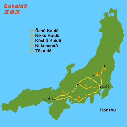
The was one of the five routes of the Edo period and it was built to connect Edo (modern-day Tokyo) with the temple-shrine complex of the Mangan-ji and Tōshōsha (now called the Rinnō-ji and Tōshōgū), which are located in the present-day city of Nikkō, Tochigi Prefecture, Japan. It was an ancient path that became formalised when power moved to Edo, and was established fully in 1617 by Tokugawa Hidetada, to give safer access to the temple-shrine mausoleum of his father, the first shogun Tokugawa Ieyasu, who was buried there that year.Nikkōdō . Accessed August 15, 2007. With only twenty-one stations, the Nikkō Kaidō was the shortest of the five routes, and it shares seventeen stations with the . Its ro ... [...More Info...] [...Related Items...] OR: [Wikipedia] [Google] [Baidu] |
Ōshū Kaidō
The was one of the five routes of the Edo period. It was built to connect Edo (modern-day Tokyo) with Mutsu Province and the present-day city of Shirakawa, Fukushima Prefecture, Japan. It was established by Tokugawa Ieyasu for government officials traveling through the area. Subroutes In addition to the established use of traveling from Edo to Mutsu Province, there were also many roads that connected from the Ōshū Kaidō. One such sub-route was the Sendaidō (仙台道), which connected Mutsu Province with Sendai. The terminus for the Sendaidō is in Aoba-ku in modern Sendai. From there, the Matsumaedō (松前道) connected Sendai with Hakodate, Hokkaidō. Though the Ōshū Kaidō has only 27 post stations,Ōshū Kaidō Map Yumekaidō. Accessed September 4, 2007. there were over 100 designated post stations when the subrout ... [...More Info...] [...Related Items...] OR: [Wikipedia] [Google] [Baidu] |
Shukuba
were post stations during the Edo period in Japan, generally located on one of the Edo Five Routes or one of its sub-routes. They were also called ''shuku-eki'' (宿駅). These post stations (or "post towns") were places where travelers could rest on their journey around the nation. They were created based on policies for the transportation of goods by horseback that were developed during the Nara and Heian periods. History These post stations were first established by Tokugawa Ieyasu shortly after the end of the Battle of Sekigahara. The first post stations were developed along the Tōkaidō (followed by stations on the Nakasendō and other routes). In 1601, the first of the Tōkaidō's fifty-three stations were developed, stretching from Shinagawa-juku in Edo to Ōtsu-juku in Ōmi Province. Not all the post stations were built at the same time, however, as the last one was built in 1624. The lodgings in the post stations were established for use by public officials and, ... [...More Info...] [...Related Items...] OR: [Wikipedia] [Google] [Baidu] |
Humid Subtropical Climate
A humid subtropical climate is a zone of climate characterized by hot and humid summers, and cool to mild winters. These climates normally lie on the southeast side of all continents (except Antarctica), generally between latitudes 25° and 40° and are located poleward from adjacent tropical climates. It is also known as warm temperate climate in some climate classifications. Under the Köppen climate classification, ''Cfa'' and ''Cwa'' climates are either described as humid subtropical climates or warm temperate climates. This climate features mean temperature in the coldest month between (or ) and and mean temperature in the warmest month or higher. However, while some climatologists have opted to describe this climate type as a "humid subtropical climate", Köppen himself never used this term. The humid subtropical climate classification was officially created under the Trewartha climate classification. In this classification, climates are termed humid subtropical when the ... [...More Info...] [...Related Items...] OR: [Wikipedia] [Google] [Baidu] |
Noda, Chiba
is a city located in the northwestern corner of Chiba Prefecture, Japan. , the city had an estimated population of 154,114 in 69,191 households and a population density of 1500 persons per km2. The total area of the city is . The city is famous for its production of soy sauce. Geography Noda is the northernmost city in Chiba Prefecture, and the 36th parallel north passes through it. It is about 40 kilometers from then prefectural capital at Chiba, and 30 to 40 kilometers from central Tokyo. The city center is surrounded by rivers on three sides, with the Shimōsa Plateau, the Tone River to the east of the city, the Edo River to the west, and the Tone Canal to the south. Ibaraki Prefecture is on the opposite bank across the Tone River, and Saitama Prefecture is on the opposite bank across the Edo River. Neighboring municipalities *Chiba Prefecture ** Kashiwa **Nagareyama *Saitama Prefecture ** Kasukabe ** Yoshikawa ** Satte ** Matsubushi ** Sugito *Ibaraki Prefecture ** Bandō ** ... [...More Info...] [...Related Items...] OR: [Wikipedia] [Google] [Baidu] |
Chiba Prefecture
is a prefecture of Japan located in the Kantō region of Honshu. Chiba Prefecture has a population of 6,278,060 (1 June 2019) and has a geographic area of . Chiba Prefecture borders Ibaraki Prefecture to the north, Saitama Prefecture to the northwest, and Tokyo to the west. Chiba is the capital and largest city of Chiba Prefecture, with other major cities including Funabashi, Matsudo, Ichikawa and Kashiwa. Chiba Prefecture is located on Japan's eastern Pacific coast to the east of Tokyo, and is part of the Greater Tokyo Area, the most populous metropolitan area in the world. Chiba Prefecture largely consists of the Bōsō Peninsula, which encloses the eastern side of Tokyo Bay and separates it from Kanagawa Prefecture. Chiba Prefecture is home to Narita International Airport, the Tokyo Disney Resort, and the Keiyō Industrial Zone. Etymology The name of Chiba Prefecture in Japanese is formed from two kanji characters. The first, , means "thousand" and the second, means " ... [...More Info...] [...Related Items...] OR: [Wikipedia] [Google] [Baidu] |


