|
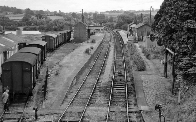
Suckley Railway Station
Suckley railway station was a station in Suckley, Worcestershire Worcestershire ( , ; written abbreviation: Worcs) is a county in the West Midlands of England. The area that is now Worcestershire was absorbed into the unified Kingdom of England in 927, at which time it was constituted as a county (see His ..., England. The station was opened on 1 March 1878 and closed on 7 September 1964.Passengers No More by G.Daniels and L.Dench second edition page 69 References Sources * Further reading * Disused railway stations in Worcestershire Railway stations in Great Britain opened in 1878 Railway stations in Great Britain closed in 1964 Former Great Western Railway stations Beeching closures in England {{WestMidlands-railstation-stub ... [...More Info...] [...Related Items...] OR: [Wikipedia] [Google] [Baidu] |
Suckley
Suckley is a village and civil parish in the Malvern Hills District in the county of Worcestershire, England, close to the border with Herefordshire. The parish includes the hamlets of Suckley Knowl (at ), Suckley Green at and Longley Green at . Covering , Suckley is geographically one of the largest parishes in Worcestershire, but one of the least populated with only around 250 residences. Seven farms use the greater part of the available land, producing apples, beef, cereals, hops, milk, oil seed rape, pears and potatoes. The eastern side of the Parish is part of the Malvern Hills Area of Outstanding Natural Beauty. Within Suckley there are several dozen micro-businesses operating from private homes, ranging from beauty therapy to furniture restoration, from computer maintenance to interior design, from motor mechanics to plumbing. Most of the population in employment commute to Malvern, Worcester, Hereford, Cheltenham or the West Midlands. The parish's population increase ... [...More Info...] [...Related Items...] OR: [Wikipedia] [Google] [Baidu] |
Worcestershire
Worcestershire ( , ; written abbreviation: Worcs) is a county in the West Midlands of England. The area that is now Worcestershire was absorbed into the unified Kingdom of England in 927, at which time it was constituted as a county (see History of Worcestershire). Over the centuries the county borders have been modified, but it was not until 1844 that substantial changes were made. Worcestershire was abolished as part of local government reforms in 1974, with its northern area becoming part of the West Midlands and the rest part of the county of Hereford and Worcester. In 1998 the county of Hereford and Worcester was abolished and Worcestershire was reconstituted, again without the West Midlands area. Location The county borders Herefordshire to the west, Shropshire to the north-west, Staffordshire only just to the north, West Midlands to the north and north-east, Warwickshire to the east and Gloucestershire to the south. The western border with Herefordshire includes a ... [...More Info...] [...Related Items...] OR: [Wikipedia] [Google] [Baidu] |
Ordnance Survey National Grid
The Ordnance Survey National Grid reference system (OSGB) (also known as British National Grid (BNG)) is a system of geographic grid references used in Great Britain, distinct from latitude and longitude. The Ordnance Survey (OS) devised the national grid reference system, and it is heavily used in their survey data, and in maps based on those surveys, whether published by the Ordnance Survey or by commercial map producers. Grid references are also commonly quoted in other publications and data sources, such as guide books and government planning documents. A number of different systems exist that can provide grid references for locations within the British Isles: this article describes the system created solely for Great Britain and its outlying islands (including the Isle of Man); the Irish grid reference system was a similar system created by the Ordnance Survey of Ireland and the Ordnance Survey of Northern Ireland for the island of Ireland. The Universal Transverse Merca ... [...More Info...] [...Related Items...] OR: [Wikipedia] [Google] [Baidu] |
Great Western Railway
The Great Western Railway (GWR) was a British railway company that linked London with the southwest, west and West Midlands of England and most of Wales. It was founded in 1833, received its enabling Act of Parliament on 31 August 1835 and ran its first trains in 1838 with the initial route completed between London and Bristol in 1841. It was engineered by Isambard Kingdom Brunel, who chose a broad gauge of —later slightly widened to —but, from 1854, a series of amalgamations saw it also operate standard-gauge trains; the last broad-gauge services were operated in 1892. The GWR was the only company to keep its identity through the Railways Act 1921, which amalgamated it with the remaining independent railways within its territory, and it was finally merged at the end of 1947 when it was nationalised and became the Western Region of British Railways. The GWR was called by some "God's Wonderful Railway" and by others the "Great Way Round" but it was famed as the "Holiday ... [...More Info...] [...Related Items...] OR: [Wikipedia] [Google] [Baidu] |
Yearsett Railway Station
Yearsett railway station was a station to the southeast of Brockhampton, Herefordshire Herefordshire () is a county in the West Midlands of England, governed by Herefordshire Council. It is bordered by Shropshire to the north, Worcestershire to the east, Gloucestershire to the south-east, and the Welsh counties of Monmouthshire ..., England. The station was opened on 2 May 1874 as a temporary terminus and closed on 22 October 1877. References Further reading * Disused railway stations in Herefordshire Railway stations in Great Britain opened in 1874 Railway stations in Great Britain closed in 1877 {{WestMidlands-railstation-stub ... [...More Info...] [...Related Items...] OR: [Wikipedia] [Google] [Baidu] |
Worcester, Bromyard And Leominster Railway
The Worcester, Bromyard and Leominster Railway was a single track branch railway line, that ran between a junction near on the West Midland Railway line south of Worcester (present day Cotswold Line) to the Shrewsbury and Hereford Railway line south of . History Construction The proposed line received Royal Assent on 1 August 1861, authorising a single track railway line from a point near Bransford Road on the West Midland Railway, through to the Shrewsbury and Hereford Railway at . Authority was also given for £200,000 capital to be raised by the selling of £10 shares, with a quarter to be purchased by the West Midland Railway, plus an additional £65,000 in loans if necessary. The limited company was formed under the chairmanship of Sir Charles Hastings, founder of the British Medical Association. Originally authorised to be constructed in five years, it eventually took 36 years to construct the complete line, opened in four sections, finishing in 1897. In a specia ... [...More Info...] [...Related Items...] OR: [Wikipedia] [Google] [Baidu] |
Knightwick Railway Station
Knightwick railway station was a station in Knightwick, Worcestershire Worcestershire ( , ; written abbreviation: Worcs) is a county in the West Midlands of England. The area that is now Worcestershire was absorbed into the unified Kingdom of England in 927, at which time it was constituted as a county (see His ..., England. The station was opened on 2 May 1874 and closed on 7 September 1964. References Sources * Further reading * Disused railway stations in Worcestershire Railway stations in Great Britain opened in 1874 Railway stations in Great Britain closed in 1964 Former Great Western Railway stations Beeching closures in England {{WestMidlands-railstation-stub ... [...More Info...] [...Related Items...] OR: [Wikipedia] [Google] [Baidu] |
Railway Stations In Great Britain Opened In 1878
Rail transport (also known as train transport) is a means of transport that transfers passengers and goods on wheeled vehicles running on rails, which are incorporated in tracks. In contrast to road transport, where the vehicles run on a prepared flat surface, rail vehicles (rolling stock) are directionally guided by the tracks on which they run. Tracks usually consist of steel rails, installed on sleepers (ties) set in ballast, on which the rolling stock, usually fitted with metal wheels, moves. Other variations are also possible, such as "slab track", in which the rails are fastened to a concrete foundation resting on a prepared subsurface. Rolling stock in a rail transport system generally encounters lower frictional resistance than rubber-tyred road vehicles, so passenger and freight cars (carriages and wagons) can be coupled into longer trains. The operation is carried out by a railway company, providing transport between train stations or freight customer faciliti ... [...More Info...] [...Related Items...] OR: [Wikipedia] [Google] [Baidu] |
Railway Stations In Great Britain Closed In 1964
Rail transport (also known as train transport) is a means of transport that transfers passengers and goods on wheeled vehicles running on rails, which are incorporated in tracks. In contrast to road transport, where the vehicles run on a prepared flat surface, rail vehicles (rolling stock) are directionally guided by the tracks on which they run. Tracks usually consist of steel rails, installed on sleepers (ties) set in ballast, on which the rolling stock, usually fitted with metal wheels, moves. Other variations are also possible, such as "slab track", in which the rails are fastened to a concrete foundation resting on a prepared subsurface. Rolling stock in a rail transport system generally encounters lower frictional resistance than rubber-tyred road vehicles, so passenger and freight cars (carriages and wagons) can be coupled into longer trains. The operation is carried out by a railway company, providing transport between train stations or freight customer facilit ... [...More Info...] [...Related Items...] OR: [Wikipedia] [Google] [Baidu] |
Former Great Western Railway Stations
A former is an object, such as a template, gauge or cutting die, which is used to form something such as a boat's hull. Typically, a former gives shape to a structure that may have complex curvature. A former may become an integral part of the finished structure, as in an aircraft fuselage, or it may be removable, being using in the construction process and then discarded or re-used. Aircraft formers Formers are used in the construction of aircraft fuselage, of which a typical fuselage has a series from the nose to the empennage, typically perpendicular to the longitudinal axis of the aircraft. The primary purpose of formers is to establish the shape of the fuselage and reduce the column length of stringers to prevent instability. Formers are typically attached to longerons, which support the skin of the aircraft. The "former-and-longeron" technique (also called stations and stringers) was adopted from boat construction, and was typical of light aircraft built until the a ... [...More Info...] [...Related Items...] OR: [Wikipedia] [Google] [Baidu] |


