|
Stadtrandsiedlung Malchow
Stadtrandsiedlung Malchow () is a German locality (''Ortsteil'') within the Berlin borough (''Bezirk'') of Pankow. Until 2001 it was part of the former Weißensee borough. History The history of this locality is related to the neighboring quarter of Malchow. Originally the ''Siedlung'' was a civil parish of it, and Malchow an autonomous Prussian municipality of Brandenburg. In 1920 they were merged into Berlin by the " Greater Berlin Act". From 1936 to 1939 the northern area of the locality was used as a sewage farm. Geography Located in the north-western suburb of Berlin, Stadtrandsiedlung Malchow borders with the Brandenburger municipality of Ahrensfelde, in the district of Barnim. The Berliner localities bordering with the ''Siedlung'' are Karow, Blankenburg, Heinersdorf, Weißensee and, in Lichtenberg borough, Neu-Hohenschönhausen, Malchow and Wartenberg. Transport The locality is crossed in the north by the Außenring railway line, but is not served by any station. A b ... [...More Info...] [...Related Items...] OR: [Wikipedia] [Google] [Baidu] |
Boroughs And Localities Of Berlin
Berlin is both a city and one of Germany’s federated states (city state). Since the 2001 administrative reform, it has been made up of twelve districts (german: Bezirke, ), each with its own administrative body. However, unlike the municipalities and counties of other German states, the Berlin districts are not territorial corporations of public law () with autonomous competencies and property, but simple administrative agencies of Berlin's state and city government, the City of Berlin forming a single municipality () since the Greater Berlin Act of 1920. Thus they cannot be equated to US or UK boroughs in the traditional meaning of the term. Each district possesses a district representatives' assembly () directly elected by proportional representation and an administrative body called district board (). The district board, comprising since October 2021 six (until then five) members - a district mayor () as head and five (earlier four) district councillors () - is elected by th ... [...More Info...] [...Related Items...] OR: [Wikipedia] [Google] [Baidu] |
Heinersdorf
Heinersdorf () is a locality in the borough of Pankow in Berlin, Germany. It is located close to the centre of Pankow. History Heinersdorf was first mentioned in a 1319 document when it was sold by Margrave Waldemar of Brandenburg to the Hospital of the Holy Ghost in Berlin. After that it changed owners several times. In 1920 it was incorporated into Greater Berlin and belonged to the former ''Pankow'' borough, until it merged with Karow, Blankenburg and Weissensee in 1985. These localities belonged to Pankow again after Berlin's 2001 administrative reform. The foundations of the fieldstone church were laid around 1300. The church features two stained glass windows from 1946 by Charles Crodel. Another landmark is the Heinersdorf water tower, which was erected in 1910. Originally part of a planned town hall that was never built, it later served as a Flak tower and as a listening station of the Red Army. Since 1991 the building has been abandoned. Heinerdorf was often in t ... [...More Info...] [...Related Items...] OR: [Wikipedia] [Google] [Baidu] |
Bundesstraße 2
The Bundesstraße 2 (abbr. B2) is Germany's longest federal highway, running some 1000 kilometres from the Polish border near Gartz to the Austrian border near Garmisch-Partenkirchen. From north to south; it passes through major cities such as Berlin, Potsdam, Leipzig, Gera, Bayreuth, Nuremberg, Augsburg, and Munich. It is largely paralleled by Bundesautobahn 9, and a small portion coincides with Bundesautobahn 952. It corresponds to a long portion of the Via Imperii of the Holy Roman Empire which continued all the way to Venice via the Brenner Pass. In Berlin B2 forms among others the following squares and streets Alexanderplatz, Karl-Liebknecht-Straße, Unter den Linden, Straße des 17. Juni, Großer Stern, Kaiserdamm, Theodor-Heuss-Platz, and Heerstraße. {{DEFAULTSORT:Bundesstrasse 2 Roads in Brandenburg Roads in Berlin Roads in Saxony Roads in Saxony-Anhalt Roads in Thuringia Roads in Bavaria 002 002, 0O2, O02, OO2, or 002 may refer to: Fiction *002, fictiona ... [...More Info...] [...Related Items...] OR: [Wikipedia] [Google] [Baidu] |
Berlin-Karow Station
Berlin-Karow station is a railway station on the Berlin–Szczecin railway in the Pankow district of Berlin. It is served by the S-Bahn line and the line NE27 (also known as the Heidekrautbahn), operated by the Niederbarnimer Eisenbahn. 2009 Train Collision On 17 April 2009, twenty-four people were injured when a regional train from Stralsund, Mecklenburg-Vorpommern, crashed into a freight train carrying propane, north of Berlin Berlin ( , ) is the capital and largest city of Germany by both area and population. Its 3.7 million inhabitants make it the European Union's most populous city, according to population within city limits. One of Germany's sixteen constitue .... The passengers and railway staff were hurt in the accident which took place 250m outside of Berlin-Karow railway station. Nine of the injured, five of them in critical condition, were taken to nearby hospitals. References Karow Karow Karow Railway stations in Germany opened in 1882 {{Berli ... [...More Info...] [...Related Items...] OR: [Wikipedia] [Google] [Baidu] |
Berlin-Wartenberg Station
Berlin-Wartenberg is a railway station in the Lichtenberg district of Berlin. It is served by the S-Bahn The S-Bahn is the name of hybrid urban- suburban rail systems serving a metropolitan region in German-speaking countries. Some of the larger S-Bahn systems provide service similar to rapid transit systems, while smaller ones often resemble co ... line . References Berlin S-Bahn stations Buildings and structures in Lichtenberg Railway stations in Germany opened in 1985 1985 establishments in East Germany {{Berlin-railstation-stub ... [...More Info...] [...Related Items...] OR: [Wikipedia] [Google] [Baidu] |
S75 (Berlin)
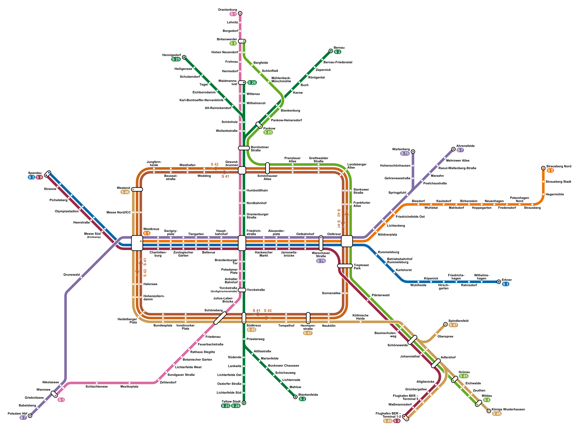
S75 is a line on the Berlin S-Bahn. It operates from Wartenberg to Warschauer Straße over: *a section of the Outer ring, completed in the early 1940s as part of the Outer freight ring The Berlin Outer Freight Ring (German: ''Güteraußenring'', GAR) was a planned ring railway around the city of Berlin, Germany. The first sections of a line to the west of the city were built in the early 20th century as part of the Brandenburg B ..., *the Prussian Eastern line, opened on 1 October 1866 and electrified on 6 November 1928, References {{Public transport in Berlin Berlin S-Bahn lines fi:S75 (Berliinin S-Bahn) ... [...More Info...] [...Related Items...] OR: [Wikipedia] [Google] [Baidu] |
Berlin S-Bahn
The Berlin S-Bahn () is a rapid transit railway system in and around Berlin, the capital city of Germany. It has been in operation under this name since December 1930, having been previously called the special tariff area ''Berliner Stadt-, Ring- und Vorortbahnen'' (Berlin city, orbital, and suburban railways). It complements the Berlin U-Bahn and is the link to many outer-Berlin areas, such as Berlin Brandenburg Airport. As such, the Berlin S-Bahn blends elements of a commuter rail service and a rapid transit system. In its first decades of operation, the trains were steam-drawn; even after the electrification of large parts of the network, a number of lines remained under steam. Today, the term ''S-Bahn'' is used in Berlin only for those lines and trains with third-rail electrical power transmission and the special Berlin S-Bahn loading gauge. The third unique technical feature of the Berlin S-Bahn, the , is being phased out and replaced by a communications-based train control ... [...More Info...] [...Related Items...] OR: [Wikipedia] [Google] [Baidu] |
Berliner Außenring
The Berlin outer ring (german: Berliner Außenring, BAR) is a long double track electrified railway, originally built by the German Democratic Republic to bypass West Berlin in preparation for the building of the Berlin Wall during the division of Germany. It was developed by East Germany for economic, transport policy, and military reasons between 1951 and 1961 and included parts of some older lines (Outer Freight Ring, Jüterbog–Nauen railway, and Michendorf–Großbeeren railway). Without the completion of the outer ring it would not have been possible to build the Berlin Wall, sealing off West Berlin, without disrupting East Germany’s transport links. The Potsdam-Schönefeld Expressway was built for similar reasons. The term ''Outer ring'' is used to distinguish the line from the Ring line of inner Berlin. Route Starting at the Anhalt line in the south, the outer ring runs from Genshagener Heide to Schönefeld Airport, Grünau Cross, Wuhlheide, Schönfließ, Golm ... [...More Info...] [...Related Items...] OR: [Wikipedia] [Google] [Baidu] |
Wartenberg (Berlin)
Wartenberg () is a German locality (''Ortsteil'') within the borough (''Bezirk'') of Lichtenberg, Berlin. Until 2001 it was part of the former borough of Hohenschönhausen. History The locality was established in the course of the German ''Ostsiedlung'' after the establishment of the Margraviate of Brandenburg by Albert the Bear in 1157. It was first mentioned in a 1270 margravial deed as ''Wardenberge'' and again in the 1375 domesday book of Emperor Charles IV. The estates of Wartenberg manor were acquired by the City of Berlin in 1882. Until 1920, it was a municipality in the former Niederbarnim district of the Prussian Brandenburg Province, then merged into Berlin with the "Greater Berlin Act". Geography Overview Wartenberg is located in the north-eastern suburb of Berlin and borders with the Brandenburger village of Lindenberg (part of Ahrensfelde municipality), in Barnim district. It borders with the Berliner localities of Falkenberg, Neu-Hohenschönhausen, Malchow and St ... [...More Info...] [...Related Items...] OR: [Wikipedia] [Google] [Baidu] |
Neu-Hohenschönhausen
Neu-Hohenschönhausen (, literally ''New Hohenschönhausen'') is a German locality (''Ortsteil'') in the borough (''Bezirk'') of Lichtenberg, Berlin. Until 2001 it was part of the former Hohenschönhausen borough. History The locality, still inhabited in the 19th century, hadn't a different name from Alt-Hohenschönhausen as part of it. The designation was used from the 1960s for this local part, to distinguish it from the old town. Geography Position Neu-Hohenschönhausen is located in the north-eastern part of Berlin. It borders with the localities of Malchow, Falkenberg, Wartenberg, Alt-Hohenschönhausen, Weißensee, Stadtrandsiedlung Malchow (both in Pankow district) and Marzahn (in Marzahn-Hellersdorf district). Subdivision The locality is divided into 4 zones (''Ortsgebiete''): * Neubaugebiet Krummer Pfuhl * Neubaugebiet Vincent-van-Gogh-Straße * Neubaugebiet Mühlengrund * Neubaugebiet Zingster Straße Transport The locality is served by tram lines M4, M5 and M17 of th ... [...More Info...] [...Related Items...] OR: [Wikipedia] [Google] [Baidu] |
Lichtenberg
Lichtenberg () is the eleventh borough of Berlin, Germany. In Berlin's 2001 administrative reform it absorbed the former borough of Hohenschönhausen. Overview The district contains the Tierpark Berlin in Friedrichsfelde, the larger of Berlin's two zoological gardens. During the period of Berlin's partition between West and East, Lichtenberg was the location of the headquarters of the Stasi, the East German state security service. Prior to the establishment of the GDR it housed the main office of the Soviet Military Administration in Berlin, and before that it was an officers' mess of the Wehrmacht. The complex is now the location of the Stasi Museum. The Berlin-Hohenschönhausen Memorial is on the site of the main remand prison of the Stasi. Additionally, Lichtenberg is the location of the German-Russian Museum, the historical venue of the unconditional surrender of the German armed forces (Wehrmacht) on 8 May 1945. Subdivision Lichtenberg is divided into 10 localities: ... [...More Info...] [...Related Items...] OR: [Wikipedia] [Google] [Baidu] |
Blankenburg (Berlin)
Blankenburg () is a German locality (''Ortsteil'') within the borough (''Bezirk'') of Pankow, Berlin. Until 2001 it was part of the former borough of Weißensee. History The locality, first mentioned in 1375, was an autonomous municipality of the former Niederbarnim district, merged into Berlin in 1920 with the " Greater Berlin Act". Geography Blankenburg is located in the north-eastern suburb of Berlin and borders with the localities of Französisch Buchholz, Karow, Stadtrandsiedlung Malchow, Heinersdorf and, in a brief point, Pankow. Transport The locality is served by the ''Berlin S-Bahn'' lines S2, S8 and S9, at Blankenburg station, and by bus lines 150, 154 and 158. Blankenburger boundary with Französisch Buchholz is crossed by the motorway A114 and the nearest exit serving the locality is the n.4 ("Pasewalker Straße"). Personalities * Johannes Maus (1916–1985), actor Photogallery File:S-Bahnhof Berlin-Blankenburg (2009).jpg, Railway station File:Blankenburg O ... [...More Info...] [...Related Items...] OR: [Wikipedia] [Google] [Baidu] |


