|
St Dogmaels
St Dogmaels ( cy, Llandudoch) is a village, parish and community in Pembrokeshire, Wales, on the estuary of the River Teifi, a mile downstream from the town of Cardigan in neighbouring Ceredigion. A little to the north of the village, further along the estuary, lies Poppit Sands beach. The parish includes the small settlement of Cippyn, south of Cemaes Head. Name The English and Welsh names seem to bear no similarity, but it has been suggested that possibly both names refer to the same saint or founder Dogmael (Dogfael), with ‘mael’ (prince) and ‘tud’ (land or people of) being added to Dog/doch as in ''Dog mael'' and ''Tud doch''. It is the current standard usage not to have a full-stop after the 'St' or an apostrophe in 'Dogmaels'. History St Dogmaels Abbey is 12th-century Tironesian and was one of the richer monastic institutions in Wales. Adjacent to the abbey ruins is the parish church (Church in Wales) of St Thomas, which appears successively to have occupie ... [...More Info...] [...Related Items...] OR: [Wikipedia] [Google] [Baidu] |
Office For National Statistics
The Office for National Statistics (ONS; cy, Swyddfa Ystadegau Gwladol) is the executive office of the UK Statistics Authority, a non-ministerial department which reports directly to the UK Parliament. Overview The ONS is responsible for the collection and publication of statistics related to the economy, population and society of the UK; responsibility for some areas of statistics in Scotland, Northern Ireland and Wales is devolved to the devolved governments for those areas. The ONS functions as the executive office of the National Statistician, who is also the UK Statistics Authority's Chief Executive and principal statistical adviser to the UK's National Statistics Institute, and the 'Head Office' of the Government Statistical Service (GSS). Its main office is in Newport near the United Kingdom Intellectual Property Office and Tredegar House, but another significant office is in Titchfield in Hampshire, and a small office is in London. ONS co-ordinates data collection wi ... [...More Info...] [...Related Items...] OR: [Wikipedia] [Google] [Baidu] |
St Dogmaels Abbey
The Abbey of St. Mary (also known as St. Dogmaels Abbey) is Grade I listed ruined abbey in St Dogmaels in Pembrokeshire, Wales, on the banks of the River Teifi and close to Cardigan and Poppit Sands. It is the ruins of a medieval abbey, originally founded in 1115 by the Fitzmartin family of Cemais. It was established by the Order of Tiron, a medieval monastic order, which owned a large number of priories and abbeys in France, England, Wales, Scotland and Ireland. It is now in ruins, but substantial parts of the abbey remain, including the western end wall, the north wall, the north transept, and eastern walls of the crypt. There are also several monastic buildings which survive to the south of the abbey and a detached 13th century building, most likely an infirmary, which is located to the south east. History The site of the abbey is thought to have been the location of a Celtic monastery founded by Dogmael, a 6th-century saint said to have been the son of Ithel ap Ceredig ... [...More Info...] [...Related Items...] OR: [Wikipedia] [Google] [Baidu] |
Nevern
Nevern ( cy, Nanhyfer) is both a parish and a community in Pembrokeshire, Wales. The community includes the settlements of Felindre Farchog, Monington, Moylgrove and Bayvil. The small village lies in the Nevern valley near the Preseli Hills of the Pembrokeshire Coast National Park east of Newport on the B4582 road. History Neolithic The area around Nevern has been occupied since at least neolithic times (about 4,000 years ago); evidence includes barrows revealed in an aerial survey during the 2018 heatwave. Norman rule When the ruler of Deheubarth, Rhys ap Tewdwr, died in battle and his lands were forfeited to the Normans, Martin de Turribus became the Marcher Lord of Kemes, with his caput at Nevern, where he took over an existing fortification. Norman castle The early 12th century Nevern Castle stood on a spur of the hill northwest of the church. Under Martin's son, Robert fitz Martin, it was the only Norman castle to successfully resist the forces of Rhys ap Gruffydd's s ... [...More Info...] [...Related Items...] OR: [Wikipedia] [Google] [Baidu] |
Wards And Electoral Divisions Of The United Kingdom
The wards and electoral divisions in the United Kingdom are electoral districts at sub-national level, represented by one or more councillors. The ward is the primary unit of English electoral geography for civil parishes and borough and district councils, the electoral ward is the unit used by Welsh principal councils, while the electoral division is the unit used by English county councils and some unitary authorities. Each ward/division has an average electorate of about 5,500 people, but ward population counts can vary substantially. As of 2021 there are 8,694 electoral wards/divisions in the UK. England The London boroughs, metropolitan boroughs and non-metropolitan districts (including most unitary authorities) are divided into wards for local elections. However, county council elections (as well as those for several unitary councils which were formerly county councils, such as the Isle of Wight and Shropshire Councils) instead use the term ''electoral division''. In s ... [...More Info...] [...Related Items...] OR: [Wikipedia] [Google] [Baidu] |
Wales Coast Path
The Wales Coast Path ( cy, Llwybr Arfordir Cymru) is a designated long-distance trail which follows, or runs close to, the coastline of Wales. Launched in 2012, the footpath is long and was heralded as the first dedicated coast path in the world to cover the entire length of a country's coastline. The Wales Coast Path runs through eleven national nature reserves and other nature reserves such as those managed by the Royal Society for the Protection of Birds and The Wildlife Trusts.www.firstnature.com - wales Coast Path . Retrieved 2 January 2012. 
[...More Info...] [...Related Items...] OR: [Wikipedia] [Google] [Baidu] |
Ceredigion Coast Path
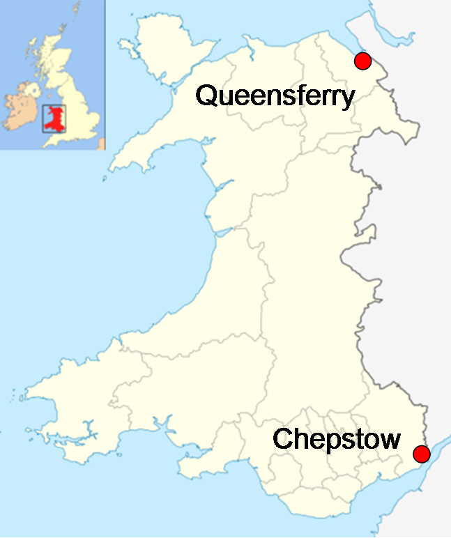
The Ceredigion Coast Path ( cy, Llwybr Arfordir Ceredigion) is a waymarked long distance footpath in the United Kingdom, on the coast of Ceredigion, Wales. It is in length, running along the coast of Cardigan Bay from Cardigan to Ynyslas The path forms one section of the Wales Coast Path, an long-distance walking route around the whole coast of Wales from Chepstow to Queensferry, opened in 2012.All-Wales Coast Path Nears Completion . ''BBC News Wales''. BBC. 17 October 2011. Retrieved 2 January 2012. Background The Ceredigion Coast Path project was funded under the EU's |
Pembrokeshire Coast Path
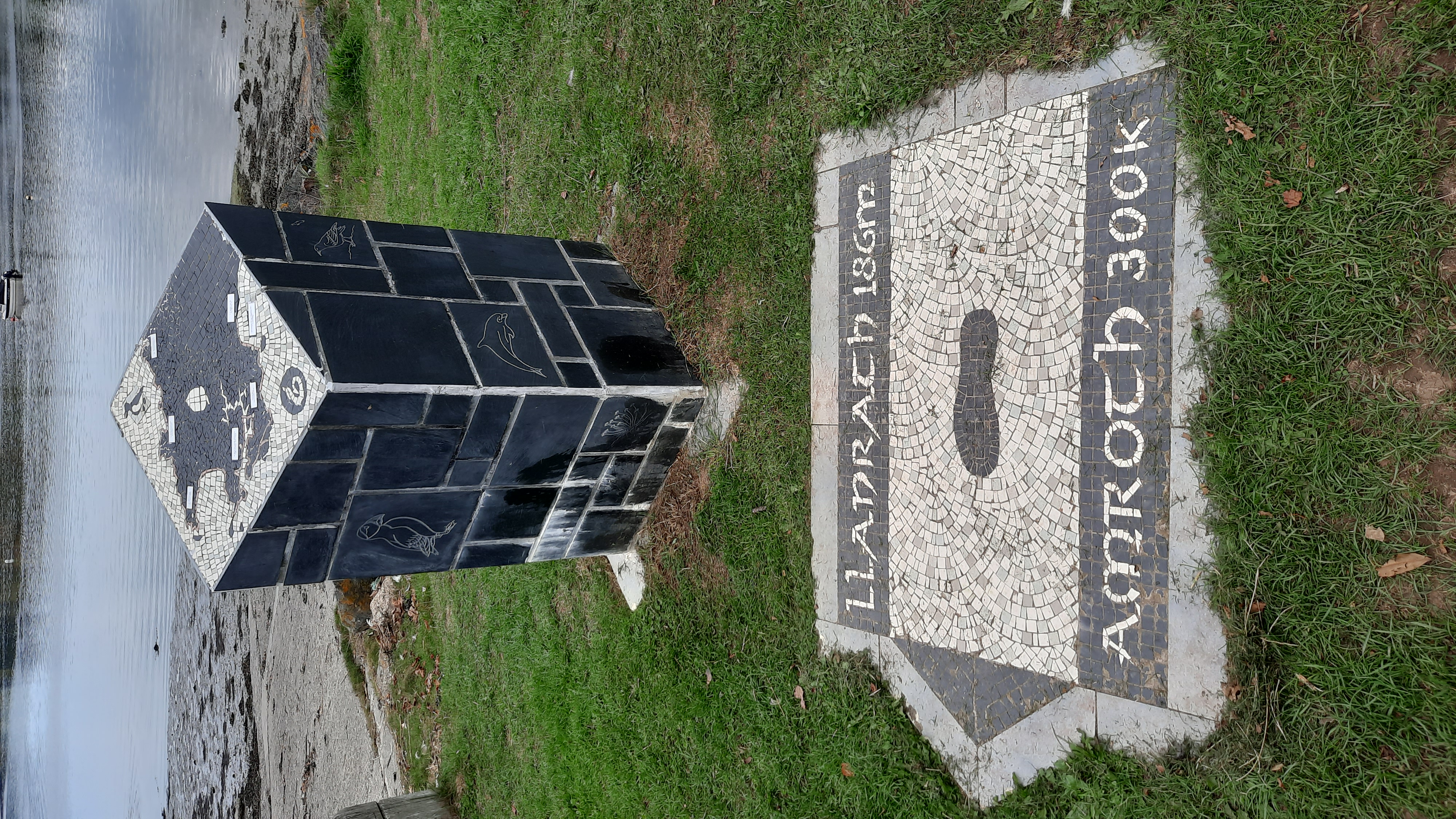
The Pembrokeshire Coast Path ( cy, Llwybr Arfordir Sir Benfro), often called the Pembrokeshire Coastal Path, is a designated National Trail in Pembrokeshire, southwest Wales. Established in 1970, it is a long-distance walking route, mostly at cliff-top level, with a total of of ascent and descent. At its highest point – Pen yr afr, on Cemaes Head – it reaches a height of , and at its lowest point – Sandy Haven crossing, near Milford Haven – it is just above low water. Whilst most of the coastline faces west, it offers – at varying points – coastal views in every direction of the compass. The southern end of the path is at Amroth, Pembrokeshire. The northern end is often regarded as being at Poppit Sands, near St. Dogmaels, Pembrokeshire, where the official plaque was originally sited but the path now continues to St. Dogmaels, where a new marker was unveiled in July 2009. Here the path links with the Ceredigion Coast Path, which c ... [...More Info...] [...Related Items...] OR: [Wikipedia] [Google] [Baidu] |
Trefriw
Trefriw () is a village and community in Conwy County Borough, Wales. It lies on the river Crafnant in North Wales, a few miles south of the site of the Roman fort of Canovium, sited at Caerhun. At the last three censuses the population of the community has been recorded as 842 in 1999, 915 in 2001, and 783 in 2011 (from a total of 368 households). Trefriw lies on the edge of Snowdonia, on the B5106 road to the north-west of Llanrwst, and about 4½ miles north of Betws-y-Coed by road. It is located on the western slopes of the glaciated Conwy valley, below the ridge of Cefn Cyfarwydd, the village having been largely built in a semicircle at the point where the river Crafnant flows from its hanging valley to join the river Conwy. The river Crafnant still provides power for the woollen mill, and in the past provided power for a number of other industries based along its banks, such as a forge which provided quarry tools. The community includes the hamlet of Llanrhychwyn. Mos ... [...More Info...] [...Related Items...] OR: [Wikipedia] [Google] [Baidu] |
Calor Village Of The Year
The Calor Village of the Year comprised 4 annual competitions organised by gas provider Calor to identify the villages that best met the following criteria: "a well-balanced, pro-active, caring community which has made the best of local opportunities to maintain and enhance the quality of life for all residents". Four separate competitions were run: * Calor Scottish Community of the Year * Calor Village of the Year for England * Calor Village of the Year for Wales * Calor Village of the Year Northern Ireland The competitions began in 1997 and ran yearly until 2009. Some 1,650 villages entered the competitions each year. List Winners included: * Ashington, West Sussex * Ashover, Derbyshire * Coniston, Cumbria Coniston is a village and civil parish in the Furness region of Cumbria, England. In the 2001 census the parish had a population of 1,058, decreasing at the 2011 census to 928. Historically part of Lancashire, it is in the southern part of the ... * St Neot, Cornw ... [...More Info...] [...Related Items...] OR: [Wikipedia] [Google] [Baidu] |
Listed Building
In the United Kingdom, a listed building or listed structure is one that has been placed on one of the four statutory lists maintained by Historic England in England, Historic Environment Scotland in Scotland, in Wales, and the Northern Ireland Environment Agency in Northern Ireland. The term has also been used in the Republic of Ireland, where buildings are protected under the Planning and Development Act 2000. The statutory term in Ireland is " protected structure". A listed building may not be demolished, extended, or altered without special permission from the local planning authority, which typically consults the relevant central government agency, particularly for significant alterations to the more notable listed buildings. In England and Wales, a national amenity society must be notified of any work to a listed building which involves any element of demolition. Exemption from secular listed building control is provided for some buildings in current use for worship, ... [...More Info...] [...Related Items...] OR: [Wikipedia] [Google] [Baidu] |
George Owen Of Henllys
George Owen of Henllys (1552 – 26 August 1613) was a Welsh antiquarian, author, and naturalist. Early life George Owen was the eldest son born to Elizabeth Herbert and William Owen in Henllys of the parish of Nevern, near Newport, Pembrokeshire. William Owen ( 1486–1574) was a successful Welsh lawyer who purchased the Lordship of Kemys. Following his father's death, he inherited the estate. Lordship of Kemys George Owen was educated in law at the Inns of Court in London. He spent considerable time fighting a series of lawsuits against family enemies in the county over ownership of manorial franchises. Wales historian During his life span he collected antiquarian information about Wales, including the heraldry, genealogy and historical buildings and structures. He also studied the topography of the county of Pembrokeshire and other parts of Wales. During his studies he performed observations of the geology of Wales, including the strata of limestone and coal. Although he d ... [...More Info...] [...Related Items...] OR: [Wikipedia] [Google] [Baidu] |
Borough
A borough is an administrative division in various English-speaking countries. In principle, the term ''borough'' designates a self-governing walled town, although in practice, official use of the term varies widely. History In the Middle Ages, boroughs were settlements in England that were granted some self-government; burghs were the Scottish equivalent. In medieval England, boroughs were also entitled to elect members of parliament. The use of the word ''borough'' probably derives from the burghal system of Alfred the Great. Alfred set up a system of defensive strong points (Burhs); in order to maintain these particular settlements, he granted them a degree of autonomy. After the Norman Conquest, when certain towns were granted self-governance, the concept of the burh/borough seems to have been reused to mean a self-governing settlement. The concept of the borough has been used repeatedly (and often differently) throughout the world. Often, a borough is a single town with ... [...More Info...] [...Related Items...] OR: [Wikipedia] [Google] [Baidu] |


