|
South Pembrokeshire
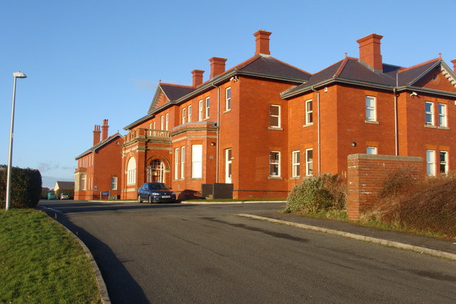
South Pembrokeshire ( cy, De Sir Benfro) was one of six local government districts of Dyfed, Wales from 1974 to 1996. Creation The district was formed on 1 April 1974 under the Local Government Act 1972, from the following parts of the administrative county of Pembrokeshire: *Narberth Rural District * Narberth Urban District * Pembroke Municipal Borough (which included Pembroke Dock) *Pembroke Rural District *Tenby Municipal Borough The map shows the district as defined above. However, in 1981, the communities of Bletherston, Clarbeston, Llandeilo Llwydarth, Llandissilio West, Llangolman, Llanycefn, Llys y Fran, Maenclochog, Mynachlog-ddu, New Moat and Vorlan were transferred to Preseli district. Premises The council was based at Llanion Park at Pembroke Dock. The building had been built in 1904 as part of the Llanion Barracks, and had been acquired by the former Pembroke Borough Council in the early 1970s to serve as its headquarters, just a couple of years before that coun ... [...More Info...] [...Related Items...] OR: [Wikipedia] [Google] [Baidu] |
Pembrokeshire Coast National Park Headquarters - Geograph
Pembrokeshire ( ; cy, Sir Benfro ) is a Local government in Wales#Principal areas, county in the South West Wales, south-west of Wales. It is bordered by Carmarthenshire to the east, Ceredigion to the northeast, and the rest by sea. The county is home to Pembrokeshire Coast National Park. The Park occupies more than a third of the area of the county and includes the Preseli Hills in the north as well as the Pembrokeshire Coast Path. Historically, mining and fishing were important activities, while industry nowadays is focused on agriculture (86 per cent of land use), oil and gas, and tourism; Pembrokeshire's beaches have won many awards. The county has a diverse geography with a wide range of geological features, habitats and wildlife. Its prehistory and modern history have been extensively studied, from tribal occupation, through Roman times, to Welsh, Irish, Norman, English, Scandinavian and Flemish influences. Pembrokeshire County Council's headquarters are in the county ... [...More Info...] [...Related Items...] OR: [Wikipedia] [Google] [Baidu] |
Clarbeston
Clarbeston ( cy, Treglarbes) is a village and parish in Pembrokeshire, Wales, east of Haverfordwest. The parish, together with Wiston and Walton East, constitute the community of Wiston. The population was 318 at the 2011 census. Name The English placename means "Clarenbald's farm", Clarenbald being a continental Germanic (perhaps Flemish) personal name.Charles, B. G., ''The Placenames of Pembrokeshire'', National Library of Wales, Aberystwyth, 1992, , pp 406 The Welsh placename is a translation of the English. Location Clarbeston Road railway station and the surrounding settlement and post town of Clarbeston Road lie to the west of the village. Parish The parish is close to, or on, the Pembrokeshire language frontier and has always had a somewhat fluctuating proportion of Welsh speakers. The parish had an area of . Its census A census is the procedure of systematically acquiring, recording and calculating information about the members of a given population. This term i ... [...More Info...] [...Related Items...] OR: [Wikipedia] [Google] [Baidu] |
Haverfordwest
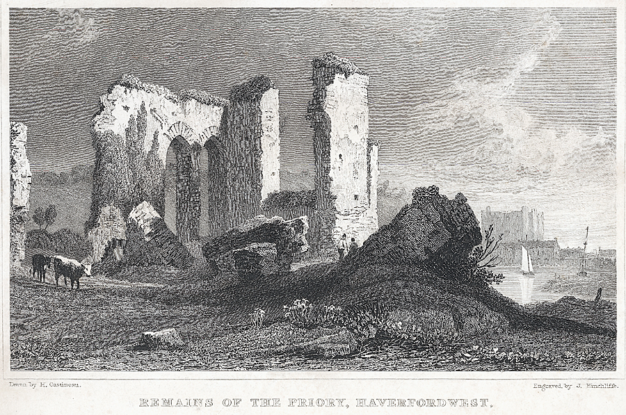
Haverfordwest (, ; cy, Hwlffordd ) is the county town of Pembrokeshire, Wales, and the most populous urban area in Pembrokeshire with a population of 14,596 in 2011. It is also a community, being the second most populous community in the county, with 12,042 people, after Milford Haven. The suburbs include the former parish of Prendergast, Albert Town and the residential and industrial areas of Withybush (housing, retail parks, hospital, airport and showground). Haverfordwest is located in a strategic position, being at the lowest bridging point of the Western Cleddau prior to the opening of the Cleddau Bridge in 1975. Topography Haverfordwest is a market town, the county town of Pembrokeshire and an important road network hub between Milford Haven, Pembroke Dock, Fishguard and St David's as a result of its position at the tidal limit of the Western Cleddau. The majority of the town, comprising the old parishes of St. Mary, St. Martin and St. Thomas, lies on the right (wes ... [...More Info...] [...Related Items...] OR: [Wikipedia] [Google] [Baidu] |
County Hall, Haverfordwest
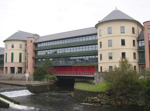
The County Hall ( cy, Neuadd y Sir) is a municipal building on Freemens Way in Haverfordwest, Pembrokeshire, Wales. It was built in 1999 and serves as the offices and meeting place of Pembrokeshire County Council. History An earlier Pembrokeshire County Council had existed from 1889 until 1974, when local government reorganisation abolished the administrative county of Pembrokeshire, splitting the area into two districts called Preseli (renamed Preseli Pembrokeshire in 1987) and South Pembrokeshire, both of which were within a new county of Dyfed. That first county council had met at Shire Hall, Haverfordwest, and from 1923 had its main administrative offices at a converted hospital on St Thomas's Green, Haverfordwest, called County Offices. Further local government reorganisation in 1996 abolished Dyfed County Council and its constituent districts. A unitary authority called Pembrokeshire was created covering the combined area of the abolished Preseli Pembrokeshire and South ... [...More Info...] [...Related Items...] OR: [Wikipedia] [Google] [Baidu] |
Preseli Pembrokeshire
Preseli Pembrokeshire (, ; cy, Preseli Sir Benfro) was one of six local government districts of Dyfed in West Wales from 1974 to 1996. Until 1987 the name of the district was Preseli. The district took its name from the Preseli Hills. Creation The district was formed on 1 April 1974 under the Local Government Act 1972, from the following parts of the administrative county of Pembrokeshire: * Cemaes Rural District *Fishguard and Goodwick Urban District *Haverfordwest Municipal Borough *Haverfordwest Rural District *Milford Haven Urban District * Neyland Urban District In 1981, a further 11 communities were transferred from South Pembrokeshire district. Premises The council's main offices were at Cambria House on Salutation Square in Haverfordwest, which had been built in 1965 as the headquarters of one of the council's predecessors, the Haverfordwest Rural District Council. Abolition On 1 April 1996 the district was abolished by the Local Government (Wales) Act 1994, merging w ... [...More Info...] [...Related Items...] OR: [Wikipedia] [Google] [Baidu] |
Preseli
Preseli Pembrokeshire (, ; cy, Preseli Sir Benfro) was one of six local government districts of Dyfed in West Wales from 1974 to 1996. Until 1987 the name of the district was Preseli. The district took its name from the Preseli Hills. Creation The district was formed on 1 April 1974 under the Local Government Act 1972, from the following parts of the administrative county of Pembrokeshire: * Cemaes Rural District *Fishguard and Goodwick Urban District *Haverfordwest Municipal Borough *Haverfordwest Rural District *Milford Haven Urban District * Neyland Urban District In 1981, a further 11 communities were transferred from South Pembrokeshire district. Premises The council's main offices were at Cambria House on Salutation Square in Haverfordwest, which had been built in 1965 as the headquarters of one of the council's predecessors, the Haverfordwest Rural District Council. Abolition On 1 April 1996 the district was abolished by the Local Government (Wales) Act 1994, merging w ... [...More Info...] [...Related Items...] OR: [Wikipedia] [Google] [Baidu] |
New Moat
New Moat ( cy, Y Mot) is a village, parish and community in Pembrokeshire, Wales. It extends from the southern edges of Mynydd Preseli to the Pembrokeshire-Carmarthenshire border. Demographics New Moat community includes the villages of New Moat, Bletherston, Llys y Fran, and Penffordd, with a combined population recorded in the 2001 census of 426, increasing to 434 at the 2011 Census. History Historically in the hundred of Dungleddy, the village takes its name from an ancient motte and bailey defence of which only the artificially built mound now survives. The Black Book of St Davids 1326 records state that the Lord of New Moat paid one penny a year to the Bishops of St Davids at Castle Morris. New Moat was once the seat of the Scourfield family, who are reported to have resided in the area since the reign of Edward I. The Scourfields provided the area of Pembrokeshire and Haverfordwest with several sheriffs and mayors, as well as Members of Parliament, including William Henry ... [...More Info...] [...Related Items...] OR: [Wikipedia] [Google] [Baidu] |
Mynachlog-ddu
Mynachlog-ddu () is a village, parish and community in the Preseli Hills, Pembrokeshire, Wales. The community includes the parish of Llangolman. Origin of the name The Welsh placename means "black monastic grange": before the Dissolution of the Monasteries, the parish belonged to St Dogmaels Abbey. Geography Mynachlog-ddu sits on a plateau above sea level between Carn Menyn (365m) and Foel Dyrch (368m) in the Preseli Hills. History Mynachlog-ddu and the surrounding Preselis are rich in prehistoric remains. It is one of the possible sites of the Battle of Mynydd Carn in 1081. By c.1100 it was under the control of the Normans. Much has been unenclosed moorland since the Middle Ages, with few houses. The village developed as housing for slate quarry workers and there has been a chapel in the village since 1794. The population of the parish in 1821 was 447. Carn Menyn is presumed to be the source of the bluestones used in the inner circle of Stonehenge. In 2000/2001 a project ... [...More Info...] [...Related Items...] OR: [Wikipedia] [Google] [Baidu] |
Maenclochog
Maenclochog () is a village, parish and Community (Wales), community in Pembrokeshire, south-west Wales. It is also the name of Maenclochog (electoral ward), an electoral ward comprising a wider area of four surrounding communities. Maenclochog Community includes the small settlement of Llanycefn () and the village of Rosebush, Pembrokeshire, Rosebush. The Maenclochog community population was 731 in 2011. Maenclochog lies south of the Preseli Hills, about one mile southeast of Rosebush on the B4313 Narberth, Pembrokeshire, Narberth to Fishguard road. Origin of the name The origin of the name Maenclochog is unclear. It appears to be made up of two Welsh words, ''maen'' ("stone") and ''clochog'' ("noisy, clamorous"). A local tale reports that there were stones near Ffynnon Fair ("Mary's Well"), to the south of the village, which rang like bells when struck, but these were blown up by treasure-hunters, in the mistaken belief that they concealed a golden treasure. This may repres ... [...More Info...] [...Related Items...] OR: [Wikipedia] [Google] [Baidu] |
Llys Y Fran
Llys y Fran is a small village and parish in the community of New Moat on the southern slopes of the Preseli Mountains in Pembrokeshire, Wales. The parish includes the small settlement of Gwastad. A notable feature is Llys y Fran Reservoir and Country Park, a popular tourist attraction. Name The name appears as Llys-y-frân on Ordnance Survey maps as well as in legislation, and the parish has been recorded with a number of spellings including ''Llysyfran'', ''Llys-y-fran'', ''Llys-y-Frân'' and ''Llys-y-Vrân''. The word ''llys'' translates into English as "court" and ''y frân'' translates as " fthe crow". History The present parish church dates from the 12th century, with alterations and improvements in the ensuing centuries, and is dedicated to St Meilyr, a 6th-century Celtic saint. Llys y Fran was originally a chapelry; in the 16th century it was controlled by various landowners in the district, but it does appear (''Llisvrayne'') as a parish on a 1578 map. One of the church ... [...More Info...] [...Related Items...] OR: [Wikipedia] [Google] [Baidu] |
Llanycefn
Maenclochog () is a village, parish and community in Pembrokeshire, south-west Wales. It is also the name of an electoral ward comprising a wider area of four surrounding communities. Maenclochog Community includes the small settlement of Llanycefn () and the village of Rosebush. The Maenclochog community population was 731 in 2011. Maenclochog lies south of the Preseli Hills, about one mile southeast of Rosebush on the B4313 Narberth to Fishguard road. Origin of the name The origin of the name Maenclochog is unclear. It appears to be made up of two Welsh words, ''maen'' ("stone") and ''clochog'' ("noisy, clamorous"). A local tale reports that there were stones near Ffynnon Fair ("Mary's Well"), to the south of the village, which rang like bells when struck, but these were blown up by treasure-hunters, in the mistaken belief that they concealed a golden treasure. This may represent nothing more than folk etymology. An alternative proposal is that the second part of the nam ... [...More Info...] [...Related Items...] OR: [Wikipedia] [Google] [Baidu] |


