|
Sokehs
Sokehs is a village and municipality on the main island in the state of Pohnpei, Federated States of Micronesia. It is the location of Palikir, the federal capital. The namesake Sokehs Peninsula is located north of the main island. Education Pohnpei State Department of Education operates public schools: * Lewetik Elementary SchoolPohnpei Schools " Pohnpei State Department of Education. Retrieved on February 23, 2018. * Pakein Elementary School * Elementary School * RSP Elementary School * Sekere Elementary School * Sokehs Powe Elementary School |
Sokehs Island
Deke Sokehs, or Sokehs Peninsula, is a mountainous peninsula on the north coast of Pohnpei in the Federated States of Micronesia. It was formerly an island, known as Sokehs Island, but it is now connected to the main island by causeway and a field of mangroves. The 1570-meter-long ''Dau Mwoakote Channel'' cuts through the mangroves, which, except in the west, is only a few meters wide. It belongs to Sokehs Municipality and lies to the west of Kolonia. Settlements from south to north include Reou, Ahseia, Soledi, Kamwele, Mwalok, Roie, Naneir, Peilong, Kepindau, and Danipei. Sokehs is the location of ''Sokehs Rock'', a prominent cliff face that is one of Micronesia's best-known geographic features. It was also the site of Sokehs Rebellion, an uprising by islanders in October 1910 against colonial German rule. The uprising was suppressed in early 1911, leading to the execution of 15 rebels and the exiling of several hundred Sokehs islanders to Palau Palau,, off ... [...More Info...] [...Related Items...] OR: [Wikipedia] [Google] [Baidu] |
Pohnpei Map
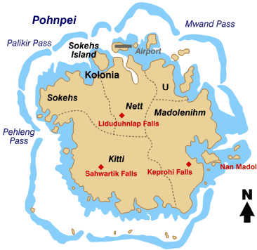
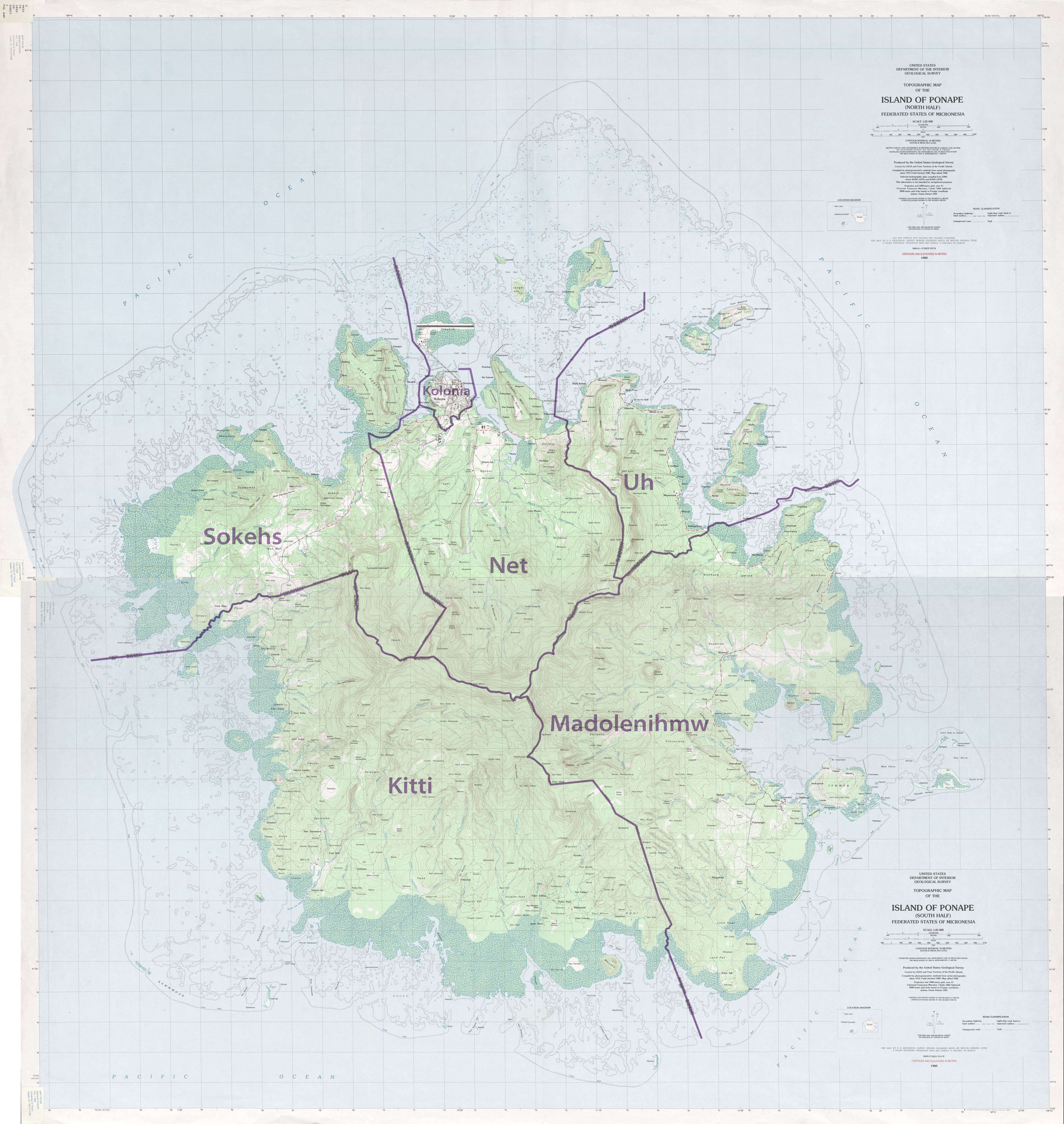
Pohnpei "upon (''pohn'') a stone altar (''pei'')" (formerly known as Ponape or Ascension, Proto-Chuukic-Pohnpeic: ''*Fawo ni pei)'' is an island of the Senyavin Islands which are part of the larger Caroline Islands group. It belongs to Pohnpei State, one of the four states in the Federated States of Micronesia (FSM). Major population centers on Pohnpei include Palikir, the FSM's capital, and Kolonia, the capital of Pohnpei State. Pohnpei Island is the largest with an area of , and a highest point of , the most populous with 36,832 people, and the most developed single island in the FSM. Pohnpei is home to the megaliths and ruined city of Nan Madol, built of artificial islands off the island's eastern shore beginning in the 8th or 9th century. An important archaeological site, it was declared a national historic site in 1985. Pohnpei contains a wealth of biodiversity. It is one of the wettest places on Earth with annual recorded rainfall exceeding each year in certain mountai ... [...More Info...] [...Related Items...] OR: [Wikipedia] [Google] [Baidu] |
Pohnpei State Department Of Education
Pohnpei State Department of Education (PDOE) is an agency of Pohnpei State, Federated States of Micronesia that operates public schools. Churchill B. Edward is the department's director. Schools it had 31 elementary schools with 556 preschool students and 8,112 elementary students, and three high schools with 2,713 students. " Pohnpei State Department of Education. December 16, 2009. Retrieved on February 23, 2018. High schools: * (formerly Pohnpei Island Central School) [...More Info...] [...Related Items...] OR: [Wikipedia] [Google] [Baidu] |
Pohnpei
Pohnpei "upon (''pohn'') a stone altar (''pei'')" (formerly known as Ponape or Ascension, Proto-Chuukic-Pohnpeic: ''*Fawo ni pei)'' is an island of the Senyavin Islands which are part of the larger Caroline Islands group. It belongs to Pohnpei State, one of the four states in the Federated States of Micronesia (FSM). Major population centers on Pohnpei include Palikir, the FSM's capital, and Kolonia, the capital of Pohnpei State. Pohnpei Island is the largest with an area of , and a highest point of , the most populous with 36,832 people, and the most developed single island in the FSM. Pohnpei is home to the megaliths and ruined city of Nan Madol, built of artificial islands off the island's eastern shore beginning in the 8th or 9th century. An important archaeological site, it was declared a national historic site in 1985. Pohnpei contains a wealth of biodiversity. It is one of the wettest places on Earth with annual recorded rainfall exceeding each year in certain mountai ... [...More Info...] [...Related Items...] OR: [Wikipedia] [Google] [Baidu] |
Palikir
Palikir () is the capital city of the Federated States of Micronesia located in the western Pacific Ocean. A town of slightly under 5,000 residents, it is part of the larger Sokehs municipality, which had a population of 6,647 , out of the nation's total population of 106,487. It is situated on the northwest side of Pohnpei island (population 34,789), a high volcanic island surrounded by a fringing coral reef. Nearby to the northeast is the island's largest settlement, the coastal town of Kolonia. It was declared the capital of Micronesia in 1989. History Pohnpei was ruled by tribal chiefs in ancient times. Palikir was formerly a tiny village of little consequence. The island of Pohnpei was encountered by the Portuguese and Spanish in the 15th century, but colonial settlement did not occur until 1886 by the Spanish. Later Germany attained the Caroline Islands via purchase from Spain at the end of the Spanish–American War in 1898. During World War I control passed to the Japanes ... [...More Info...] [...Related Items...] OR: [Wikipedia] [Google] [Baidu] |
Kolonia
Kolonia is a coastal town and the capital of Pohnpei State in the Federated States of Micronesia (FSM). It was also the former FSM capital before being replaced by Palikir in 1989, located nearby to the southwest in the municipality of Sokehs. It has 6,074 people. Description Kolonia Town is located in the north central section of Pohnpei Island. It was formerly part of Nett municipality but has been a separate municipality since May 1965. The population of the town was 6,074 (2010 Census). It is the largest population center on Pohnpei and the commercial hub of the island. The land area of Kolonia amounts to 1.5 km², with a large number of buildings lying just outside the town limits. History Kolonia's history is deeply marked by Pohnpei's multiple foreign occupiers, and evidence of their former presence is found throughout the town and island. Traditionally, Pohnpei's power center was in Madolenihmw, on the southeastern part of the island. The area now known as Kolonia w ... [...More Info...] [...Related Items...] OR: [Wikipedia] [Google] [Baidu] |
U, Pohnpei
U, also written Uh, is one of the administrative divisions of Pohnpei State, Federated States of Micronesia. U bears the shortest place name in the Federated States of Micronesia, and one of the shortest in the world. Description U is one of the six municipalities located in the main island of Pohnpei. It corresponds to the northeastern sector of the island. U had 2,289 inhabitants according to the 2008 census. Alohkapw is the main town. A channel known as Kepidewen Alohkapw marks the boundary between U and Madolenihmw municipalities. Education Pohnpei State Department of Education operates public schools: * Awak Elementary SchoolPohnpei Schools " Pohnpei State Department of Education. Retrieved on February 23, 2018. * Saladak Elementary School |
Oroluk
Oroluk waas one of the administrative divisions of Pohnpei State, Federated States of Micronesia. In 1985, it became part of Sokehs Municipality. Description Oroluk municipality included Oroluk Atoll and Minto Reef. This municipality is uninhabited, after a population of 6 was counted in the 1980 census. Minto Reef, the northwesternmost limit of Pohnpei State, uninhabited and has only a small sand bank, no vegetated island. See also * Madolenihmw * Kitti (municipality) * U, Pohnpei * Nett * Kapingamarangi * Pingelap * Sapwuahfik * Nukuoro * Mokil * Kolonia * Sokehs * Palikir Palikir () is the capital city of the Federated States of Micronesia located in the western Pacific Ocean. A town of slightly under 5,000 residents, it is part of the larger Sokehs municipality, which had a population of 6,647 , out of the natio ... References External linksTrust Territory of the Pacific Islands - General Population Characteristics, 1980* POHNPEI (Islas Carolinas orientales). 3º pa ... [...More Info...] [...Related Items...] OR: [Wikipedia] [Google] [Baidu] |
Bailey Olter High School
Bailey Olter High School, formerly Pohnpei Island Central School (PICS), ." Embassy of the Federated States of Micronesia Washington DC. Retrieved on February 23, 2018. "Bailey Olter High School (former PICS) P.O. Box 250 Kolonia, Pohnpei FM 96941" and Pacific Islands Central School, is a senior high school in , , , |
Federated States Of Micronesia
The Federated States of Micronesia (; abbreviated FSM) is an island country in Oceania. It consists of four states from west to east, Yap, Chuuk, Pohnpei and Kosraethat are spread across the western Pacific. Together, the states comprise around 607 islands (a combined land area of approximately ) that cover a longitudinal distance of almost just north of the equator. They lie northeast of Indonesia and Papua New Guinea, south of Guam and the Marianas, west of Nauru and the Marshall Islands, east of Palau and the Philippines, about north of eastern Australia, 3,400 km (2,133 mi) southeast of Japan, and some southwest of the main islands of the Hawaiian Islands. While the FSM's total land area is quite small, the country's waters occupy more than of the Pacific Ocean, giving the country the 14th-largest exclusive economic zone in the world. The sovereign island nation's capital is Palikir, located on Pohnpei Island, while the largest city is Weno, located in ... [...More Info...] [...Related Items...] OR: [Wikipedia] [Google] [Baidu] |
Kitti (municipality)
Kitti, also written as Kiti, is one of the twelve administrative divisions of the Micronesian state of Pohnpei. It is located in the southwest of the island of Pohnpei, to the south of Mount Nanlaud. Education Pohnpei State Department of Education operates public schools: * Nanpei Memorial High School a.k.a. Kitti High School * Enipein SchoolPohnpei Schools " Pohnpei State Department of Education. Retrieved on February 23, 2018. * Nanpei Memorial Elementary School * Pehleng Elementary School * Rohi Elementary School * Salapwuk Elementary School * Seinwar Elementary School * Wone Elementary School See also * |
Administrative Divisions Of The Federated States Of Micronesia
The Federated States of Micronesia is a federation divided into four states, which are further divided into various cities and municipalities. States Cities *Palikir, Pohnpei State – ''National capital'' * Colonia, Yap State *Kolonia, Pohnpei State *Lelu, Kosrae, Lelu, Kosrae *Tol, Federated States of Micronesia, Tol, Chuuk State *Weno, Chuuk State Municipalities Chuuk State * Eot (island), Eot * Ettal (island), Ettal * Fala-Beguets * Fananu * Fefan * Kutu (island), Kutu * Losap * Lukunor * Magur (island), Magur *Moch, Chuuk, Moch * Weno, Moen * Murilo * Nama (island), Nama * Namoluk * Nomwin * Onari * Oneop * Ono, Chuuk, Ono * Param, Chuuk, Param * Pis-Losap * Pisaras * Pulap * Pulusuk * Poluwat, Puluwat * Romanum (island), Romanum * Ruo, Micronesia, Ruo * Satawan * Ta (island), Ta * Tamatam * Tol (island), Tol * Tonowas, Tonowas (Dublon) * Tsis * Udot (island), Udot * Ulul * Uman Island, Uman Kosrae * Lelu, Kosrae, Lelu * Malem, Kosrae, Malem * Tafunsak * Utwe, Ut ... [...More Info...] [...Related Items...] OR: [Wikipedia] [Google] [Baidu] |


