|
Slot Assumburg
Slot Assumburg is a castle in the east of Heemskerk in the province of North Holland North Holland ( nl, Noord-Holland, ) is a province of the Netherlands in the northwestern part of the country. It is located on the North Sea, north of South Holland and Utrecht, and west of Friesland and Flevoland. In November 2019, it had a ... in the Netherlands. Castle Characteristics Predecessor The current castle dates from 1450. However, the many finds of (large medieval bricks), and pottery from earlier times made it quite certain that the current castle had a predecessor. In 2021 this was discovered by geophysical survey with Electromagnetic (EM) conductivity technique. Just north of the current castle, there was a round castle bailey of 12 m diameter, surrounded by a moat. On it was a round brick tower of 9.5 m diameter. Historical records refer to a house with moat and a flattened hill. Between 1399 and 1446 this hill (motte) was leveled and replaced by an or ... [...More Info...] [...Related Items...] OR: [Wikipedia] [Google] [Baidu] |
Heemskerk
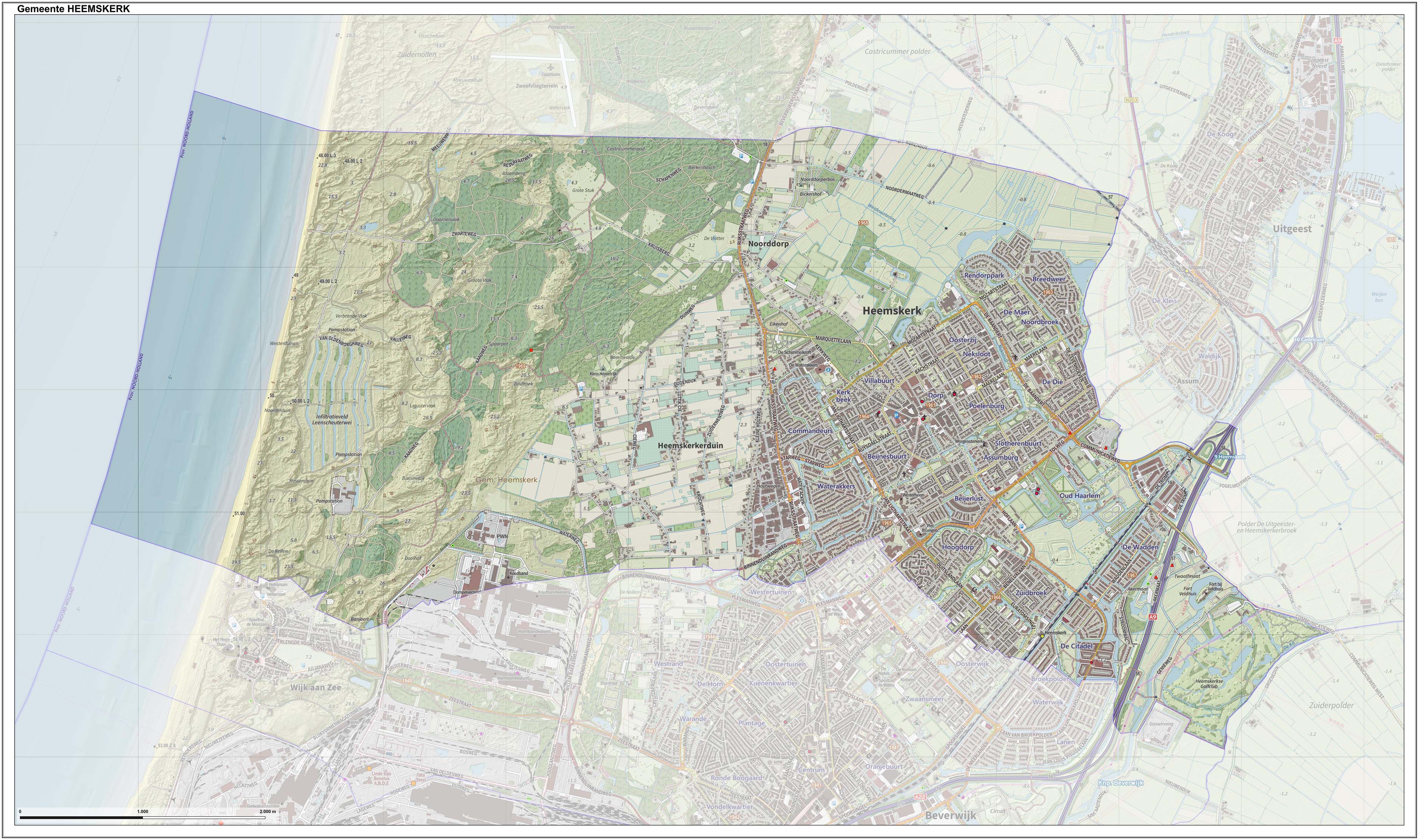
Heemskerk () is a municipality and a town in the Netherlands, in the province of North Holland. It is located in the Kennemerland region. Local government As of March 2022, the municipal council of Heemskerk consists of 25 seats, which are divided as follows: * Heemskerk Lokaal - 9 seats * Liberaal Heemskerk - 3 seats * Democrats 66 - 3 seats * Green Left - 3 seats * People's Party for Freedom and Democracy - 3 seats * Labour Party - 2 seats * Christian Democratic Appeal - 2 seats The CDA, Heemskerk Lokaal, Liberaal Heemskerk and D66 form the governing coalition. The (non-elected) mayor of Heemskerk is currently K.S. Heldoorn ( Labour Party). History It is not certain where the name of Heemskerk comes from. The town was already known during the Middle Ages. In an official deed from the year of 1063, the town was known as ''Hemezen Kyrica'', Latinized Frisian meaning Church of Hemezen, a Frisian nun who lived in a religious house there. Heemskerk knows many historical monumen ... [...More Info...] [...Related Items...] OR: [Wikipedia] [Google] [Baidu] |
Netherlands
) , anthem = ( en, "William of Nassau") , image_map = , map_caption = , subdivision_type = Sovereign state , subdivision_name = Kingdom of the Netherlands , established_title = Before independence , established_date = Spanish Netherlands , established_title2 = Act of Abjuration , established_date2 = 26 July 1581 , established_title3 = Peace of Münster , established_date3 = 30 January 1648 , established_title4 = Kingdom established , established_date4 = 16 March 1815 , established_title5 = Liberation Day (Netherlands), Liberation Day , established_date5 = 5 May 1945 , established_title6 = Charter for the Kingdom of the Netherlands, Kingdom Charter , established_date6 = 15 December 1954 , established_title7 = Dissolution of the Netherlands Antilles, Caribbean reorganisation , established_date7 = 10 October 2010 , official_languages = Dutch language, Dutch , languages_type = Regional languages , languages_sub = yes , languages = , languages2_type = Reco ... [...More Info...] [...Related Items...] OR: [Wikipedia] [Google] [Baidu] |
North Holland
North Holland ( nl, Noord-Holland, ) is a province of the Netherlands in the northwestern part of the country. It is located on the North Sea, north of South Holland and Utrecht, and west of Friesland and Flevoland. In November 2019, it had a population of 2,877,909 and a total area of , of which is water. From the 9th to the 16th century, the area was an integral part of the County of Holland. During this period West Friesland was incorporated. In the 17th and 18th century, the area was part of the province of Holland and commonly known as the Noorderkwartier (English: "Northern Quarter"). In 1840, the province of Holland was split into the two provinces of North Holland and South Holland. In 1855, the Haarlemmermeer was drained and turned into land. The provincial capital is Haarlem (pop. 161,265). The province's largest city and also the largest city in the Netherlands is the Dutch capital Amsterdam, with a population of 862,965 as of November 2019. The King's Commissi ... [...More Info...] [...Related Items...] OR: [Wikipedia] [Google] [Baidu] |
Geophysical Survey (archaeology)
In archaeology, geophysical survey is ground-based physical sensing techniques used for archaeological imaging or mapping. Remote sensing and marine surveys are also used in archaeology, but are generally considered separate disciplines. Other terms, such as "geophysical prospection" and "archaeological geophysics" are generally synonymous. Overview Geophysical survey is used to create maps of subsurface archaeological features. Features are the non-portable part of the archaeological record, whether standing structures or traces of human activities left in the soil. Geophysical instruments can detect buried features when their physical properties contrast measurably with their surroundings. In some cases individual artifacts, especially metal, may be detected as well. Readings taken in a systematic pattern become a data set that can be rendered as image maps. Survey results can be used to guide excavation and to give archaeologists insight into the patterning of non-exca ... [...More Info...] [...Related Items...] OR: [Wikipedia] [Google] [Baidu] |
Uitgeest
Uitgeest () is a municipality and a town in the Netherlands, in the province of North Holland. Population centres The municipality of Uitgeest consists of the following cities, towns, villages and/or districts: Topography ''Dutch topographic map of the municipality of Uitgeest, June 2015'' Local government The municipal council of Uitgeest consists of 15 seats, which are divided as follows: Tourist information No less than five windmills can be seen in the polder landscape surrounding the village. Uitgeest was the birthplace (in 1550) of Cornelis Corneliszoon, inventor of the wind-powered sawmill. An industrial heritage park, centered on sawmill De Hoop, is under construction. The village has a Reformed church dating back to the early 14th Century and lakeside marina. The outdoor kart-racing track of 670m had to make room for development of houses, so one tourist attraction has been lost. Fort along Den Ham (between Uitgeest and Krommenie) was one of the 42 forts o ... [...More Info...] [...Related Items...] OR: [Wikipedia] [Google] [Baidu] |
Oud Haerlem Castle
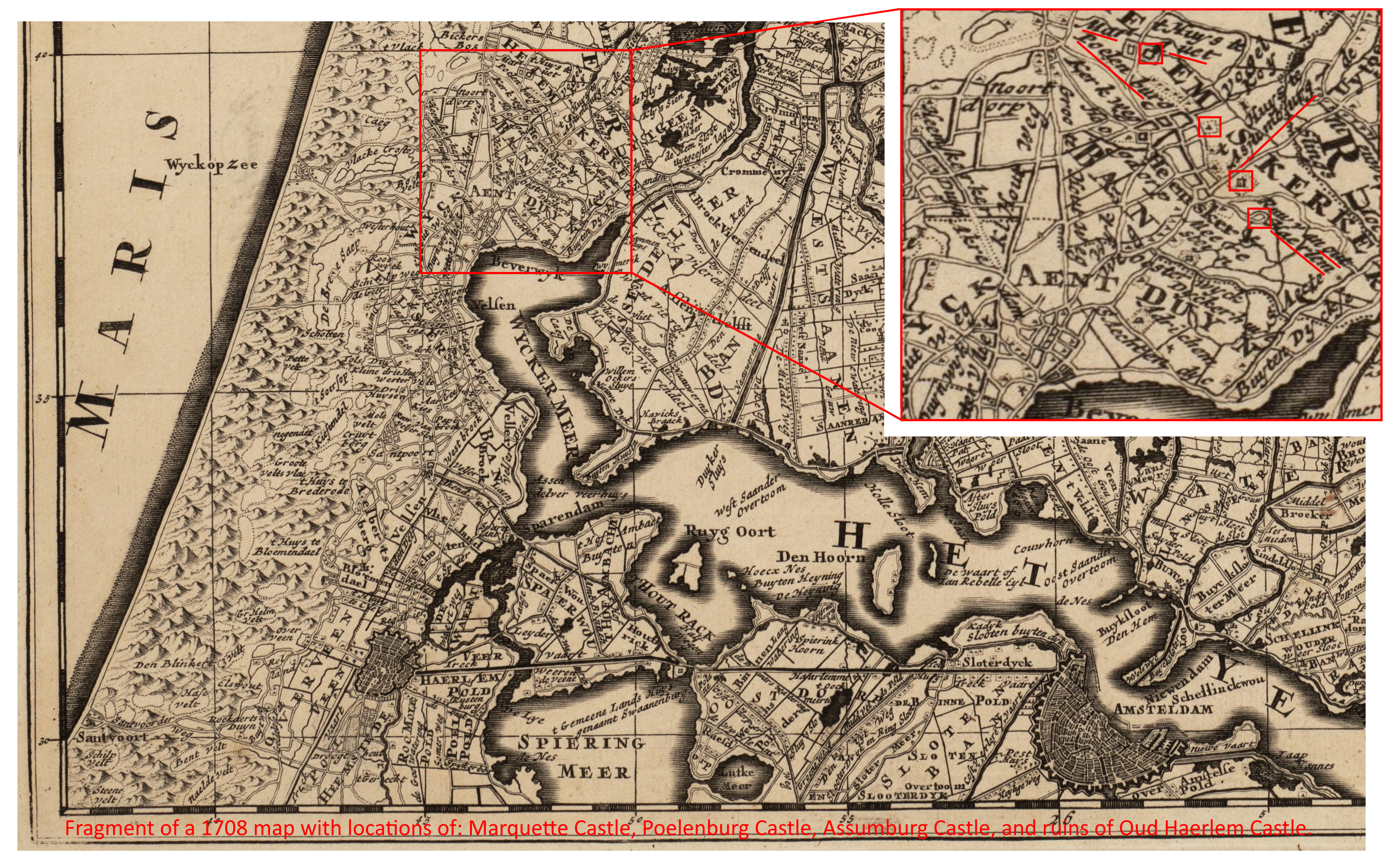
Oud Haerlem Castle was a very strong castle in Holland. In 1351 it was demolished after a long siege. Location The location of Oud Haerlem castle is on the eastern fringe of what is now Heemskerk, just west of Amsterdam. It is 400 meter south-southeast of Assumburg Castle, which probably also dates from the thirteenth century, but was much smaller at the time. Somewhat further north northwest of Assumburg was Poelenburg Castle, of which nothing remains. About three kilometer north northwest of Oud Haerlem is Marquette Castle, which used to be called Heemskerk Castle. Marquette Castle was a large round water castle, of which only later, more square parts remain. The unusually high concentration of castles in the area has been related to the contemporary geography of the area. The 1708 map still shows how the IJ reached far inland in medieval times. It continued in the now disappeared Wijkermeer, and left only the dunes and a very narrow strip of land to connect the parts of Ho ... [...More Info...] [...Related Items...] OR: [Wikipedia] [Google] [Baidu] |
Marquette Castle
Marquette Castle is an 18th-century manor house in Heemskerk, Netherlands, occupying the site of the previous 13th century Heemkskerk Castle, or . Castle Characteristics Heemskerk, the first castle The first version of Marquette Castle was a round water castle dating from the 13th century. The round water castle is known from many old pictures. These suggest at least one building along its wall. They also show its later use as a walled garden with a pond. In 1802 the last remains of the water castle were demolished. All that remained were the very wide moats. In 2021 the castle terrains were investigated with ground-penetrating radar and two other non-invasive techniques. These showed the water castle, as well as its gatehouse. The outer diameter of the water castle proved to have been about 40 m. This is larger than Egmond Castle's round water castle which measures slightly less than 30 m. Apart from the known round water castle, other parts of the first cas ... [...More Info...] [...Related Items...] OR: [Wikipedia] [Google] [Baidu] |
National Monuments Organization
National may refer to: Common uses * Nation or country ** Nationality – a ''national'' is a person who is subject to a nation, regardless of whether the person has full rights as a citizen Places in the United States * National, Maryland, census-designated place * National, Nevada, ghost town * National, Utah, ghost town * National, West Virginia, unincorporated community Commerce * National (brand), a brand name of electronic goods from Panasonic * National Benzole (or simply known as National), former petrol station chain in the UK, merged with BP * National Car Rental, an American rental car company * National Energy Systems, a former name of Eco Marine Power * National Entertainment Commission, a former name of the Media Rating Council * National Motor Vehicle Company, Indianapolis, Indiana, USA 1900-1924 * National Supermarkets, a defunct American grocery store chain * National String Instrument Corporation, a guitar company formed to manufacture the first r ... [...More Info...] [...Related Items...] OR: [Wikipedia] [Google] [Baidu] |


