|
Slauson Avenue
Slauson Avenue is a major east–west thoroughfare traversing the central part of Los Angeles County, California. It was named for the land developer and Los Angeles Board of Education member J. S. Slauson. It passes through Culver City, Ladera Heights, View Park-Windsor Hills, South Los Angeles, Huntington Park, Maywood, Commerce, Montebello, Pico Rivera, Whittier, and Santa Fe Springs. The street runs from McDonald Street in Culver City and to Santa Fe Springs Road, where it becomes Mulberry Drive in Whittier. Mulberry Drive ends at Scott Avenue in South Whittier. Transit Metro Rail There are three major transit stations (two light rail) on Slauson Avenue. They include the Slauson Station of the Metro A Line and the Hyde Park Station on the Metro K Line. Metro Bus and Freeways Slauson/I-110 Station of the Metro J Line is elevated in the median of Interstate 110 freeway. Metro Local line 108 operates on Slauson Avenue. The eastern terminus of the State Route ... [...More Info...] [...Related Items...] OR: [Wikipedia] [Google] [Baidu] |
Culver City, California
Culver City is a city in Los Angeles County, California, United States. As of the 2020 census, the population was 40,779. Founded in 1917 as a "whites only" sundown town, it is now an ethnically diverse city with what was called the "third-most diverse school district in California" in 2020. In the 1920s, the city became a center for film and later television production, best known as the home of Metro-Goldwyn-Mayer studios. From 1932 to 1986, it was the headquarters for the Hughes Aircraft Company. National Public Radio West and Sony Pictures Entertainment have headquarters in the city. The city was named after its founder, Harry Culver. It is mostly surrounded by the city of Los Angeles, but also shares a border with the unincorporated area of Ladera Heights. Over the years, it has annexed more than 40 pieces of adjoining land and now comprises about . History Early history Archaeological evidence suggests a human presence in the area of present-day Culver City since a ... [...More Info...] [...Related Items...] OR: [Wikipedia] [Google] [Baidu] |
Maywood, California
Maywood is a small Gateway city in Los Angeles County. At , Maywood is the third-smallest incorporated city in Los Angeles County. It is bordered by the cities of Bell on the south, Vernon on the north and west, Huntington Park on the southwest, and Commerce on the east. It is the most densely-populated city in California, and has the highest proportion of Latinos, immigrants, and undocumented immigrants in the county. As of July 1, 2010, Maywood became the first municipality in California to outsource all of its city services, dismantling its police department, laying off all city employees except for the city manager, city attorney and elected officials, and contracting with outside agencies for the provision of all municipal services. The population was 27,395 at the 2010 census. History The land on which Maywood now stands had been populated by Native American tribes for centuries. The area that would later become Maywood was deeded in 1781 by the Spanish monarchy to Span ... [...More Info...] [...Related Items...] OR: [Wikipedia] [Google] [Baidu] |
Bethlehem Steel
The Bethlehem Steel Corporation was an American steelmaking company headquartered in Bethlehem, Pennsylvania. For most of the 20th century, it was one of the world's largest steel producing and shipbuilding companies. At the height of its success and productivity, the company was a symbol of American manufacturing leadership in the world, and its decline and ultimate liquidation in the late 20th century is similarly cited as an example of America's diminished manufacturing leadership. From its founding in 1857 through its 2003 dissolution, Bethlehem Steel's headquarters and primary steel mill manufacturing facilities were based in Bethlehem, Pennsylvania in the Lehigh Valley region of the United States. The company's steel was used in the construction of many of America's largest and most famed structures. Among major buildings, Bethlehem produced steel for 28 Liberty Street, the Chrysler Building, the Empire State Building, Madison Square Garden, Rockefeller Center, and the Wa ... [...More Info...] [...Related Items...] OR: [Wikipedia] [Google] [Baidu] |
Florence Avenue
Florence Avenue is a major east–west street in central Los Angeles County and South Los Angeles, in Southern California. 150px, The oldest operating McDonald's is on Florence Ave at Lakewood, in Downey, California. Route It is bounded in the east by Mills Avenue at Janine Drive in Whittier. At Telegraph Road, it changes to Florence. West of La Cienega Boulevard, it swerves into Aviation Boulevard, which is a north–south street, in the City of Inglewood. Florence Avenue runs through the cities of Inglewood, Los Angeles, Huntington Park (where it intersects Pacific Boulevard), Bell, Bell Gardens, Downey, Santa Fe Springs, and unincorporated Los Angeles County bordering the City of Whittier. Florence Avenue also crosses the San Diego Freeway (Interstate 405), Harbor Freeway (Interstate 110), Long Beach Freeway (Interstate 710), San Gabriel River Freeway (Interstate 605), and Santa Ana Freeway (Interstate 5). An unconnected portion of Florence Avenue is located ... [...More Info...] [...Related Items...] OR: [Wikipedia] [Google] [Baidu] |
Vernon Avenue
Vernon may refer to: Places Australia *Vernon County, New South Wales Canada *Vernon, British Columbia, a city *Vernon, Ontario France * Vernon, Ardèche *Vernon, Eure United States * Vernon, Alabama * Vernon, Arizona * Vernon, California * Lake Vernon, California * Vernon, Colorado * Vernon, Connecticut * Vernon, Delaware * Vernon, Florida, a city * Vernon Lake (Idaho) * Vernon, Illinois * Vernon, Indiana * Vernon, Kansas * Vernon Community, Hestand, Kentucky * Vernon Parish, Louisiana ** Vernon Lake, a man-made lake in the parish * Vernon, Michigan * Vernon Township, Isabella County, Michigan * Vernon Township, Shiawassee County, Michigan * Vernon, Jasper County, Mississippi * Vernon, Madison County, Mississippi * Vernon, Winston County, Mississippi * Vernon Township, New Jersey * Vernon (town), New York ** Vernon (village), New York * Vernon (Mount Olive, North Carolina), a historic plantation house * Vernon Township, Crawford County, Ohio * Vernon Township, Scioto Cou ... [...More Info...] [...Related Items...] OR: [Wikipedia] [Google] [Baidu] |
Washington Boulevard (Los Angeles)
Washington Boulevard is an east-west arterial road in Los Angeles County, California spanning a total of 27.4 miles (44 km). Its western terminus is the Pacific Ocean just west of Pacific Avenue and straddling the border of the Venice Beach and Marina Peninsula neighborhoods of Los Angeles. The Boulevard extends eastbound to the city of Whittier, at Whittier Boulevard. It is south of Venice Boulevard for most of its length. At Wade Street, Washington Place is formed adjacent and parallel and lasts until just east of Sepulveda Boulevard, where it merges back into Washington Boulevard. Washington merges into Culver Boulevard briefly, but forms back into its own street at Canfield Avenue. Washington Boulevard, which is four lanes, primarily passes through locations in the mid-southern portion of Los Angeles County. The communities to the west include affluent areas such as Marina del Rey and Ladera Heights. Further east it passes between Crestview and Culver City and through ... [...More Info...] [...Related Items...] OR: [Wikipedia] [Google] [Baidu] |
California State Route 90
State Route 90 (SR 90) is a state highway in the U.S. state of California that consists of two unconnected pieces in Greater Los Angeles. Most of the western portion of SR 90 is the Marina Freeway, a short freeway in southwestern Los Angeles and the nearby suburbs, linking Marina del Rey to the rest of Greater Los Angeles. SR 90 begins at Lincoln Boulevard ( State Route 1) near Marina del Rey as the Marina Expressway. It then goes past a few intersections before becoming the Marina Freeway. It then continues eastward approximately along the border between the Del Rey and Westchester neighborhoods of the city of Los Angeles before terminating in Slauson Avenue in southern Culver City to just past Culver Boulevard. The eastern portion of SR 90 runs along Imperial Highway between Beach Boulevard ( State Route 39) in La Habra and State Route 91 in Anaheim Hills, also passing through Brea and Yorba Linda. A stretch in Yorba Linda between Yorba Linda Boulevard and Orangethorpe ... [...More Info...] [...Related Items...] OR: [Wikipedia] [Google] [Baidu] |
Metro Local
Los Angeles Metro Bus is the transit bus service in Los Angeles County, California operated by the Los Angeles County Metropolitan Transportation Authority (Metro). In , the system had a ridership of , or about per weekday as of . , there are 113 routes in the system. Metro employs the drivers that operate most routes, but some are contracted out to MV Transportation, Southland Transit, and Transdev. Los Angeles Metro has the third largest fleet in North America, with 2,320 buses, about 80 percent are standard length ( or longer) and 17 percent are high-capacity articulated buses. History The Metro Bus brand dates back to the 1993 founding of Metro, but many of the routes in the system are little changed from the bus routes of the prior Southern California Rapid Transit District (RTD) or the streetcar routes operated by the Pacific Electric Red Cars or the Los Angeles Railway Yellow Cars. Starting in 2003, Metro operated its bus network under three different brands: oran ... [...More Info...] [...Related Items...] OR: [Wikipedia] [Google] [Baidu] |
Route 110 (California)
Route 110, consisting of State Route 110 (SR 110) and Interstate 110 (I-110), is a state and auxiliary Interstate Highway in the Los Angeles metropolitan area of the US state of California. The entire route connects San Pedro and the Port of Los Angeles with Downtown Los Angeles and Pasadena. The southern segment from San Pedro to I-10 in downtown Los Angeles is signed as I-110, while the northern segment to Pasadena is signed as SR 110. The entire length of I-110, as well as SR 110 south of the Four Level Interchange with US Route 101 (US 101), is the Harbor Freeway, and SR 110 north from US 101 to Pasadena is the historic Arroyo Seco Parkway, the first freeway in the western United States. Route description Route 110 is part of the California Freeway and Expressway System, and is part of the National Highway System, a network of highways that are considered essential to the country's economy, defense, and mobility ... [...More Info...] [...Related Items...] OR: [Wikipedia] [Google] [Baidu] |
J Line (Los Angeles Metro)
The J Line (formerly the Silver Line, sometimes listed as Line 910/950) is a bus rapid transit route that runs between El Monte, Downtown Los Angeles and Gardena, with some trips continuing to San Pedro. It is one of the two lines in the Metro Busway system operated by the Los Angeles County Metropolitan Transportation Authority (Metro). The J Line offers frequent, all-stops service along the El Monte Busway and the Harbor Transitway, two grade-separated transit facilities built into the Southern California freeway system. The line was created on December 13, 2009, as part of the conversion of the facilities from high-occupancy vehicle lanes into high-occupancy toll lanes (branded as Metro ExpressLanes) that allow solo drivers to pay a toll to use lanes. The tolls collected have been used to operate the J Line and refurbish the aged stations on the line. As J Line buses travel along the El Monte Busway and the Harbor Transitway they serve stations built into the center ... [...More Info...] [...Related Items...] OR: [Wikipedia] [Google] [Baidu] |
K Line (Los Angeles Metro)
The K Line is a light rail line running north-south between the Jefferson Park and Westchester neighborhoods of Los Angeles, California, passing through various South Los Angeles neighborhoods and the city of Inglewood. It is one of seven lines in the Los Angeles Metro Rail system operated by the Los Angeles County Metropolitan Transportation Authority (LACMTA). It was opened on October 7, 2022, making it the system's newest line. The K Line represents the initial operating segment of the Crenshaw/LAX Line project, which began construction in 2014. A segment connecting to the C Line via a wye is expected to open in fall 2023; the C and K Lines will be integrated and services realigned at that time, although the service pattern has yet to be determined. A connection to the new LAX Automated People Mover is planned for late 2024. Service description Route The Metro K Line's northern terminus is at Expo/Crenshaw station, a transfer point to the E Line. The K Line stat ... [...More Info...] [...Related Items...] OR: [Wikipedia] [Google] [Baidu] |
A Line (Los Angeles Metro)
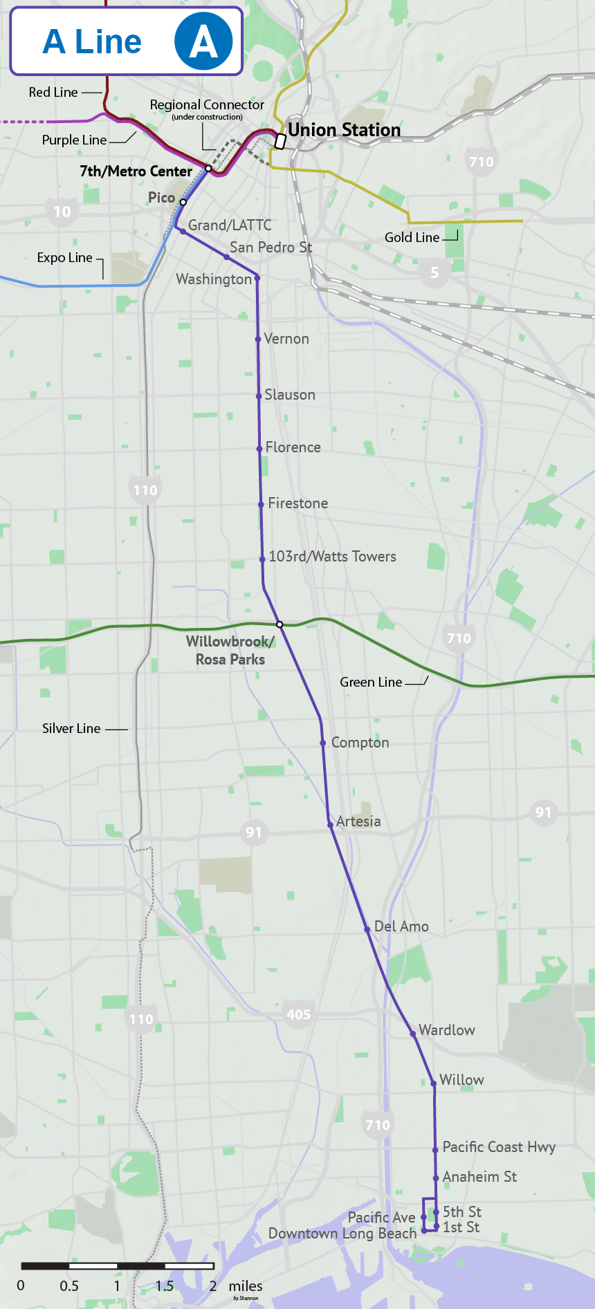
The A Line (formerly, from 1990-2019, and colloquially known as Blue Line) is a light rail line running north–south between Los Angeles and Long Beach, California, passing through Downtown Los Angeles, South Los Angeles, Watts, Willowbrook, Compton, Rancho Dominguez, and Long Beach in Los Angeles County. It is one of seven lines in the Metro Rail system. Opened in 1990, it is the system's oldest and third-busiest line with an estimated 22.38 million boardings per year . It is operated by the Los Angeles County Metropolitan Transportation Authority. The A Line passes near the cities of Vernon, Huntington Park, South Gate, Lynwood, and Carson. The famous Watts Towers art installation is visible from the train tracks near 103rd Street station. The under-construction Regional Connector will directly link this line to Union Station and into the San Gabriel Valley along the current route of the L Line, resulting in a longer A Line and the elimination of the L Line. Se ... [...More Info...] [...Related Items...] OR: [Wikipedia] [Google] [Baidu] |


