|
Skatin First Nations
The Skatin First Nations, aka the Skatin Nations, are a band government of the In-SHUCK-ch Nation, a small group of the larger St'at'imc people who are also referred to as Lower Stl'atl'imx. The Town of Skatin - the St'at'imcets version of the Chinook Jargon ''Skookumchuck''- is located 4 km south of T'sek Hot Spring- ''alt. spelling T'sek Hot Spring'' - commonly & formerly named both St. Agnes' Well & Skookumchuck Hot Springs The community is 28 km south of the outlet of Lillooet Lake on the east side of the Lillooet River. It is approximately 75 km south of the town of Pemberton and the large reserve of the Lil'wat branch of the St'at'imc at Mount Currie. Other bands nearby are Samahquam at Baptiste Smith IR on the west side of the Lillooet River at 30 km. and Xa'xtsa First Nations; the latter is located at Port Douglas, near the mouth of the Lillooet River where it enters the head of Harrison Lake. The N'Quatqua First Nation on Anderson Lake, betw ... [...More Info...] [...Related Items...] OR: [Wikipedia] [Google] [Baidu] |
Band Government
In Canada, an Indian band or band (french: bande indienne, link=no), sometimes referred to as a First Nation band (french: bande de la Première Nation, link=no) or simply a First Nation, is the basic unit of government for those peoples subject to the ''Indian Act'' (i.e. status Indians or First Nations). Bands are typically small groups of people: the largest in the country, the Six Nations of the Grand River First Nation had 22,294 members in September 2005, and many have a membership below 100 people. Each First Nation is typically represented by a band council (french: conseil de bande) chaired by an elected chief, and sometimes also a hereditary chief. As of 2013, there were 614 bands in Canada. Membership in a band is controlled in one of two ways: for most bands, membership is obtained by becoming listed on the Indian Register maintained by the government. As of 2013, there were 253 First Nations which had their own membership criteria, so that not all status Indians are ... [...More Info...] [...Related Items...] OR: [Wikipedia] [Google] [Baidu] |
Anderson Lake (British Columbia)
Anderson Lake is located about 25 miles North of the town of Pemberton, British Columbia and is about 28.5 km2 (11 sq mi) in area and around 21 km (13 mi) in length. Its maximum depth is 215 meters (705 feet). It is drained by the Seton River, which feeds Seton Lake and so the Fraser River. It is fed by the Gates River, which drains from the Pemberton Pass divide with the Birkenhead River valley towards Pemberton- Mount Currie. It and Seton Lake were originally the same lake, which was cut in half between ten and twenty thousand years ago by a large landslide from the north face of the Cayoosh Range, which fronts Anderson Lake on the east. The slide created a locality known today as Seton Portage, which combined with the steamer ''Lady of The Lake'' played a key role on the route of the Douglas Road during the Fraser Canyon Gold Rush of 1858–59.http://www.library.ubc.ca/archives/pdfs/bchf/bchq_1946_1.pdf At its head, near the mouth of the Gates River, is ... [...More Info...] [...Related Items...] OR: [Wikipedia] [Google] [Baidu] |
Glazier Creek Indian Reserve No
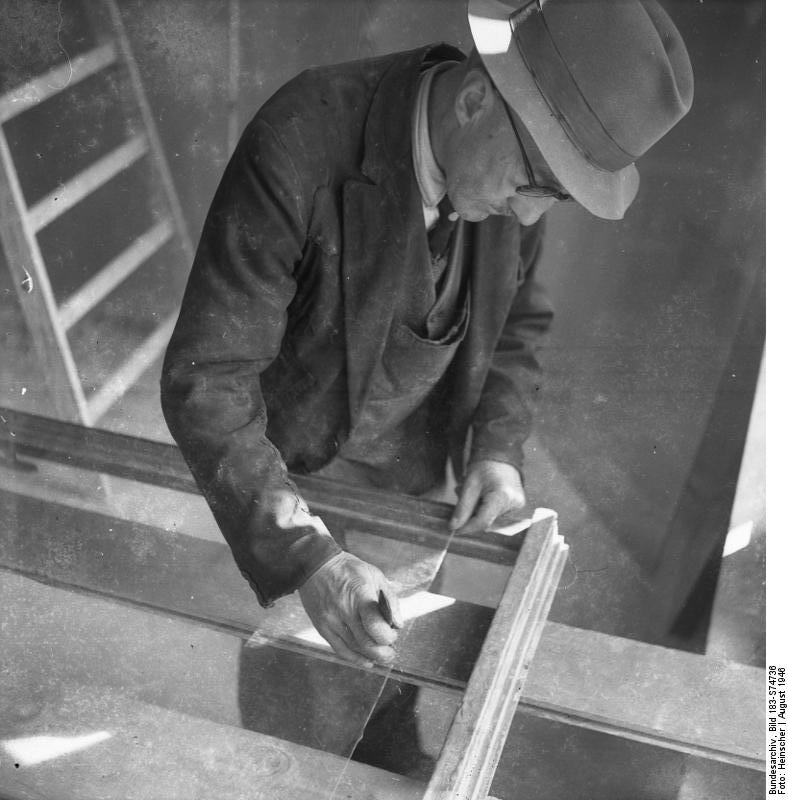
A glazier is a tradesman responsible for cutting, installing, and removing glass (and materials used as substitutes for glass, such as some plastics).Elizabeth H. Oakes, ''Ferguson Career Resource Guide to Apprenticeship Programs'' ( Infobase: 3d ed., 2006), p. 356. They also refer to blueprints to figure out the size, shape, and location of the glass in the building. They may have to consider the type and size of scaffolding they need to stand on to fit and install the glass. Glaziers may work with glass in various surfaces and settings, such as cutting and installing windows, doors, shower doors, skylights, storefronts, display cases, mirrors, facades, interior walls, ceilings, and tabletops.Glaziers (profile in the |
Franks Indian Reserve No
The Franks ( la, Franci or ) were a group of Germanic peoples whose name was first mentioned in 3rd-century Roman sources, and associated with tribes between the Lower Rhine and the Ems River, on the edge of the Roman Empire.H. Schutz: Tools, Weapons and Ornaments: Germanic Material Culture in Pre-Carolingian Central Europe, 400-750. BRILL, 2001, p.42. Later the term was associated with Romanized Germanic dynasties within the collapsing Western Roman Empire, who eventually commanded the whole region between the rivers Loire and Rhine. They imposed power over many other post-Roman kingdoms and Germanic peoples. Beginning with Charlemagne in 800, Frankish rulers were given recognition by the Catholic Church as successors to the old rulers of the Western Roman Empire. Although the Frankish name does not appear until the 3rd century, at least some of the original Frankish tribes had long been known to the Romans under their own names, both as allies providing soldiers, and as enemi ... [...More Info...] [...Related Items...] OR: [Wikipedia] [Google] [Baidu] |
Harrison Hot Springs
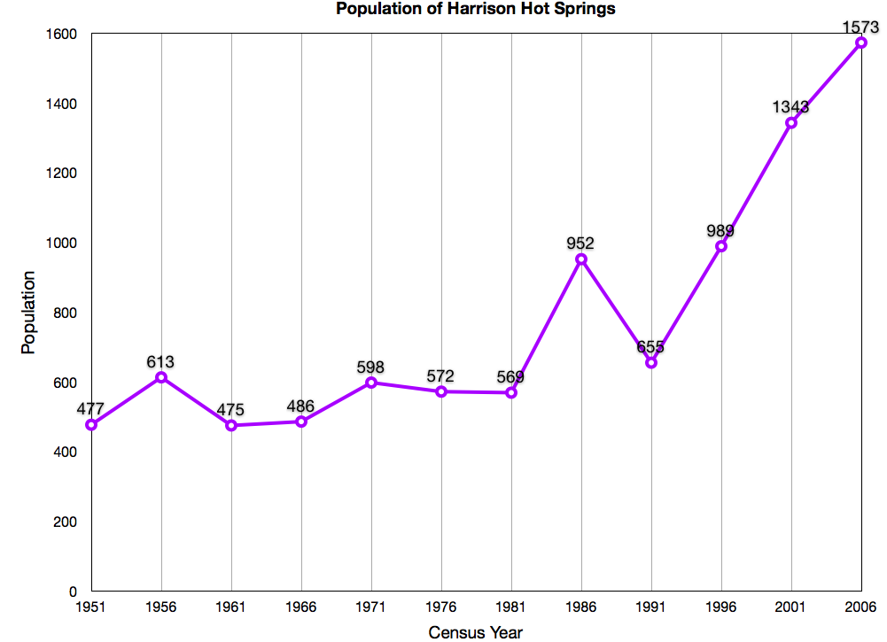
The Village of Harrison Hot Springs is a small community at the southern end of Harrison Lake in the Fraser Valley of British Columbia. It is a member of the Fraser Valley Regional District; its immediate neighbour is the District of Kent and included in it, the town of Agassiz. It is a resort community known for its hot springs and has a population of just over 1500 people. It is named after Benjamin Harrison, a former deputy governor for the Hudson's Bay Company. History The Village of Harrison Hot Springs has been a small resort community since 1886 when the opening of the Canadian Pacific Railway brought the lakeside springs within a short carriage ride of the transcontinental mainline. In its first promotion as a resort it was known as St. Alice's Well, although Europeans had discovered it (not new to indigenous communities) decades earlier when a party of goldfield-bound travelers on Harrison Lake capsized into what they thought was their doom, only to discover the lake ... [...More Info...] [...Related Items...] OR: [Wikipedia] [Google] [Baidu] |
Missionary Oblates Of Mary Immaculate
The Missionary Oblates of Mary Immaculate (OMI) is a missionary religious congregation in the Catholic Church. It was founded on January 25, 1816, by Eugène de Mazenod, a French priest born in Aix-en-Provence in the south of France on August 1, 1782, who was to be recognized later as a Catholic saint. The congregation was given recognition by Pope Leo XII on February 17, 1826. , the congregation was composed of 3,631 priests and lay brothers usually living in community. Oblate means a person dedicated to God or God's service. Their traditional salutation is ("Praised be Jesus Christ"), to which the response is ("And Mary Immaculate"). Members use the post-nominal letters, "OMI". As part of its mission to evangelize the "abandoned poor", OMI are known for their mission among the Indigenous peoples of Canada, and their historic administration of at least 57 schools within the Canadian Indian residential school system. Those oblate schools have been associated with many cases ... [...More Info...] [...Related Items...] OR: [Wikipedia] [Google] [Baidu] |
Lower Mainland
The Lower Mainland is a geographic and cultural region of the mainland coast of British Columbia that generally comprises the regional districts of Metro Vancouver and Fraser Valley. Home to approximately 3.05million people as of the 2021 Canadian census, the Lower Mainland contains sixteen of the province's 30 most populous municipalities and approximately 60% of the province's total population. The region is the traditional territory of the Sto:lo, a Halkomelem-speaking people of the Coast Salish linguistic and cultural grouping. Boundaries Although the term ''Lower Mainland'' has been recorded from the earliest period of colonization in British Columbia, it has never been officially defined in legal terms. The term has historically been in popular usage for over a century to describe a region that extends from Horseshoe Bay south to the Canada–United States border and east to Hope at the eastern end of the Fraser Valley. This definition makes the term ''Lower Mainland'' a ... [...More Info...] [...Related Items...] OR: [Wikipedia] [Google] [Baidu] |
British Columbia Interior
, settlement_type = Region of British Columbia , image_skyline = , nickname = "The Interior" , subdivision_type = Country , subdivision_name = , subdivision_type1 = Province , subdivision_name1 = , parts_type = Principal cities , p1 = Kelowna , p2 = Kamloops , p3 = Prince George , p4 = Vernon , p5 = Penticton , p6 = West Kelowna , p7 = Fort St. John , p8 = Cranbrook , area_blank1_title = 14 Districts , area_blank1_km2 = 669,648 , area_footnotes = , elevation_max_m = 4671 , elevation_min_m = 127 , elevation_max_footnotes = Mt. Fairweather , elevation_min_footnotes = Fraser River , population_as_of = 2016 , population = 961,155 , population_density_km2 ... [...More Info...] [...Related Items...] OR: [Wikipedia] [Google] [Baidu] |
Fraser Canyon
The Fraser Canyon is a major landform of the Fraser River where it descends rapidly through narrow rock gorges in the Coast Mountains en route from the Interior Plateau of British Columbia to the Fraser Valley. Colloquially, the term "Fraser Canyon" is often used to include the Thompson Canyon from Lytton to Ashcroft, since they form the same highway route which most people are familiar with, although it is actually reckoned to begin above Williams Lake, British Columbia at Soda Creek Canyon near the town of the same name. Geology The canyon was formed during the Miocene period (23.7–5.3 million years ago) by the river cutting into the uplifting Interior Plateau. From the northern Cariboo to Fountain, the river follows the line of the huge Fraser Fault, which runs on a north–south axis and meets the Yalakom Fault a few miles downstream from Lillooet. Exposures of lava flows are present in cliffs along the Fraser Canyon. They represent volcanic activity in the southern ... [...More Info...] [...Related Items...] OR: [Wikipedia] [Google] [Baidu] |
Cariboo Road
The Cariboo Road (also called the Cariboo Wagon Road, the Great North Road or the Queen's Highway) was a project initiated in 1860 by the Governor of the Colony of British Columbia, James Douglas. It involved a feat of engineering stretching from Fort Yale to Barkerville, B.C. through extremely hazardous canyon territory in the Interior of British Columbia. Between the 1860s and the 1880s the Cariboo Road existed in three versions as a surveyed and constructed wagon-road route. The first Cariboo Wagon Road surveyed in 1861 and built in 1862 followed the original Hudson's Bay Company's Harrison Trail (Port Douglas) route from Lillooet to Clinton, 70 Mile House, 100 Mile House, Lac La Hache, 150 Mile House to the contract end around Soda Creek and Alexandria at the doorstep of the Cariboo Gold Fields. The second Cariboo Wagon Road (or Yale Cariboo Road) operated during the period of the fast stage-coaches and freight-wagon companies headquartered in Yale: 1865 to 1885. Fr ... [...More Info...] [...Related Items...] OR: [Wikipedia] [Google] [Baidu] |


