|
Sissipahaw
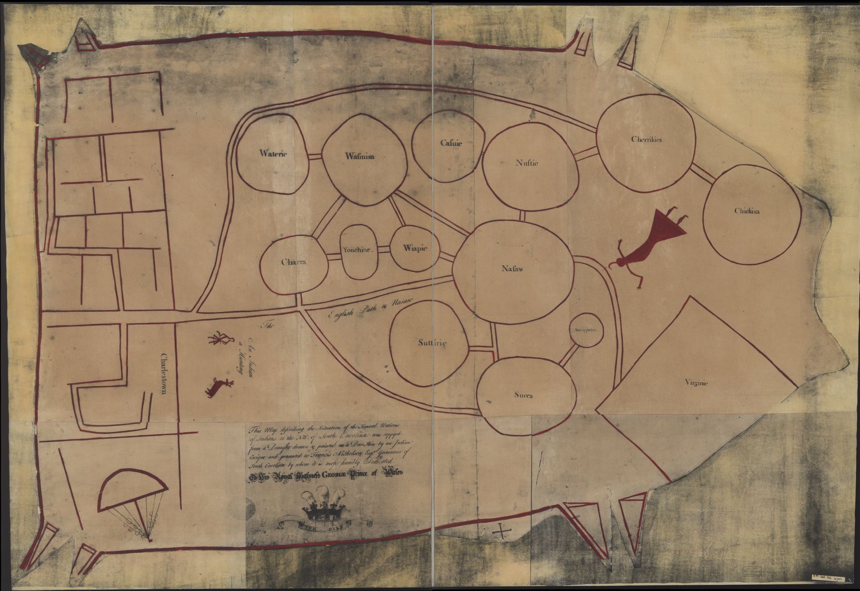
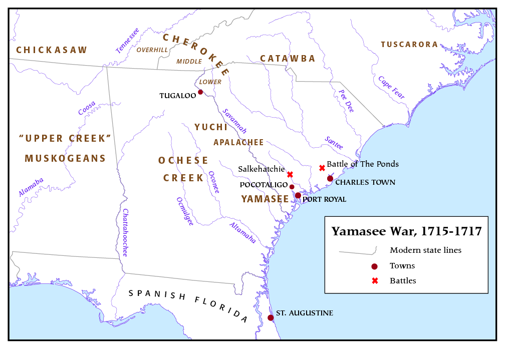
The Sissipahaw or Haw were a Native American tribe of North Carolina. They are also variously recorded as ''Saxahapaw'', ''Sauxpa'', ''Sissipahaus'', etc. Their settlements were generally located in the vicinity of modern-day Saxapahaw, North Carolina on the Haw River in Alamance County upstream from Cape Fear. They are possibly first recorded by the Spaniard Vendera in the 16th century as the ''Sauxpa'' in South Carolina. Their last mention in history is that the tribe joined the Yamasee against the English colonists in the Yamasee War of 1715. Some scholars speculate that they may have been a branch of the Shakori due to being so closely associated with that tribe but others disagree with this assumption. Name The meaning of ''sissipahaw'' is unknown but it probably derives from a Siouan language. Colonel John Barnwell reported in a letter that the Sissipahaw were called Shacioes by some during the Tuscarora War. Linguist Ives Goddard proposed that this may be the Sissipa ... [...More Info...] [...Related Items...] OR: [Wikipedia] [Google] [Baidu] |
Alamance County, North Carolina
Alamance County (), from the North Carolina Collection's website at the University of North Carolina at Chapel Hill. Retrieved September 18, 2012. is a county in North Carolina. As of the 2020 census, the population was 171,415. Its county seat is Graham. Formed in 1849 from Orange County to the east, Alamance County has been the site of significant historical events, textile manufacturing, and agriculture. Alamance County comprises the Burlington Metropolitan Statistical Area, which is also included in the Greensboro–Winston-Salem– High Point Combined Statistical Area. The 2018 estimated population of the metropolitan area was 166,436. History Before being formed as a county, the region had at least one known small Southeastern tribe of Native Americans in the 18th century, the Sissipahaw, who lived in the area bounded by modern Saxapahaw, the area known as the Hawfields, and the Haw River. European settlers entered the region in the late 17th century chiefly following ... [...More Info...] [...Related Items...] OR: [Wikipedia] [Google] [Baidu] |
Shakori
The Shakori were an indigenous people of the Southeastern Woodlands. They were thought to be a Siouan people, closely allied with other nearby tribes such as the Eno and the Sissipahaw. As their name is also recorded as Shaccoree, they can be confused with the Sugaree, but the latter are Catawba people. Yardley in 1654 wrote about a Tuscarora guide's accounts of the ''Cacores'' people from ''Haynoke'' who, although smaller in stature and number, were able to evade the Tuscarora. Their villages were located around what is now Hillsborough, North Carolina along the banks of the Eno and Shocco rivers. Culture Although little is known about the Shakori, at the time of contact, they were not noted as being noticeably different from the surrounding tribes. They made their wigwams and other structures out of interwoven saplings and sticks; these were covered in mud as opposed to the bark typically used by other nearby tribes. They were described as being similar to traditional dwell ... [...More Info...] [...Related Items...] OR: [Wikipedia] [Google] [Baidu] |
Indigenous Peoples Of The Southeastern Woodlands
Indigenous peoples of the Southeastern Woodlands, Southeastern cultures, or Southeast Indians are an ethnographic classification for Native Americans who have traditionally inhabited the area now part of the Southeastern United States and the northeastern border of Mexico, that share common cultural traits. This classification is a part of the Eastern Woodlands. The concept of a southeastern cultural region was developed by anthropologists, beginning with Otis Mason and Frank Boas in 1887. The boundaries of the region are defined more by shared cultural traits than by geographic distinctions.Jackson and Fogelson 3 Because the cultures gradually instead of abruptly shift into Plains, Prairie, or Northeastern Woodlands cultures, scholars do not always agree on the exact limits of the Southeastern Woodland culture region. Shawnee, Powhatan, Waco, Tawakoni, Tonkawa, Karankawa, Quapaw, and Mosopelea are usually seen as marginally southeastern and their traditional lands represent the b ... [...More Info...] [...Related Items...] OR: [Wikipedia] [Google] [Baidu] |
Catawba People
The Catawba, also known as Issa, Essa or Iswä but most commonly ''Iswa'' (Catawba: '' Ye Iswąˀ'' – "people of the river"), are a federally recognized tribe of Native Americans, known as the Catawba Indian Nation. Their current lands are in South Carolina, on the Catawba River, near the city of Rock Hill. Their territory once extended into North Carolina, as well, and they still have legal claim to some parcels of land in that state. They were once considered one of the most powerful Southeastern tribes in the Carolina Piedmont, as well as one of the most powerful tribes in the South as a whole, with other, smaller tribes merging into the Catawba as their post-contact numbers dwindled due to the effects of colonization on the region. The Catawba were among the East Coast tribes who made selective alliances with some of the early European colonists, when these colonists agreed to help them in their ongoing conflicts with other tribes. These were primarily the tribes of ... [...More Info...] [...Related Items...] OR: [Wikipedia] [Google] [Baidu] |
Yamasee War
The Yamasee War (also spelled Yamassee or Yemassee) was a conflict fought in South Carolina from 1715 to 1717 between British settlers from the Province of Carolina and the Yamasee and a number of other allied Native American peoples, including the Muscogee, Cherokee, Catawba, Apalachee, Apalachicola, Yuchi, Savannah River Shawnee, Congaree, Waxhaw, Pee Dee, Cape Fear, Cheraw, and others. Some of the Native American groups played a minor role, while others launched attacks throughout South Carolina in an attempt to destroy the colony. Native Americans killed hundreds of colonists and destroyed many settlements, and they killed traders throughout the southeastern region. Colonists abandoned the frontiers and fled to Charles Town, where starvation set in as supplies ran low. The survival of the South Carolina colony was in question during 1715. The tide turned in early 1716 when the Cherokee sided with the colonists against the Creek, their traditional enemy. The la ... [...More Info...] [...Related Items...] OR: [Wikipedia] [Google] [Baidu] |
Indians NW Of South Carolina
Indian or Indians may refer to: Peoples South Asia * Indian people, people of Indian nationality, or people who have an Indian ancestor ** Non-resident Indian, a citizen of India who has temporarily emigrated to another country * South Asian ethnic groups, referring to people of the Indian subcontinent, as well as the greater South Asia region prior to the 1947 partition of India * Anglo-Indians, people with mixed Indian and British ancestry, or people of British descent born or living in the Indian subcontinent * East Indians, a Christian community in India Europe * British Indians, British people of Indian origin The Americas * Indo-Canadians, Canadian people of Indian origin * Indian Americans, American people of Indian origin * Indigenous peoples of the Americas, the pre-Columbian inhabitants of the Americas and their descendants ** Plains Indians, the common name for the Native Americans who lived on the Great Plains of North America ** Native Americans in the Uni ... [...More Info...] [...Related Items...] OR: [Wikipedia] [Google] [Baidu] |
Wigwam
A wigwam, wickiup, wetu (Wampanoag), or wiigiwaam (Ojibwe, in syllabics: ) is a semi-permanent domed dwelling formerly used by certain Native American tribes and First Nations people and still used for ceremonial events. The term ''wickiup'' is generally used to refer to these kinds of dwellings in the Southwestern United States and Western United States and Northwest Alberta, Canada, while ''wigwam'' is usually applied to these structures in the Northeastern United States as well as Ontario and Quebec in central Canada Central Canada (french: Centre du Canada, sometimes the Central provinces) is a region consisting of Canada's two largest and most populous provinces: Ontario and Quebec. Geographically, they are not at the centre of Canada but instead overlap w .... The names can refer to many distinct types of Indigenous structures regardless of location or cultural group. The wigwam is not to be confused with the Native Plains tipi, which has a different construction, ... [...More Info...] [...Related Items...] OR: [Wikipedia] [Google] [Baidu] |
Tuscarora Language
Tuscarora, sometimes called , was the Iroquoian language of the Tuscarora people, spoken in southern Ontario, Canada, North Carolina and northwestern New York around Niagara Falls, in the United States, before going into hibernation in late 2020. The historic homeland of the Tuscarora was in eastern North Carolina, in and around the Goldsboro, Kinston, and Smithfield areas. The name ''Tuscarora'' ( ) means "hemp people," after the Indian hemp or milkweed, which they use in many aspects of their society. refers to the long shirt worn as part of the men's regalia, and so the name literally means "long shirt people." Tuscarora is recently extinct, the last fluent first language speaker having died in 2020. In the mid-1970s, 50 people spoke it on the Tuscarora Reservation (Lewiston, New York) and the Six Nations of the Grand River First Nation (near Brantford, Ontario). ThTuscarora School in Lewistonhas striven to keep Tuscarora alive as a heritage language by teaching children ... [...More Info...] [...Related Items...] OR: [Wikipedia] [Google] [Baidu] |
Haw River
The Haw River is a tributary of the Cape Fear River, approximately 110 mi (177 km) long, that is entirely contained in north central North Carolina in the United States. It was first documented as the "Hau River" by John Lawson, an English botanist, in his 1709 book "A New Voyage to Carolina." The name is shortened from Saxapahaw, from the Catawban ''/sak'yápha:/'', "piedmont, foothill", from ''/sak/'', "hill", plus ''/yápha:/'', "step". The river gives its name to a small town that formed on its banks. Course The Haw rises in the Piedmont country, in northeast Forsyth County, near the border with Guilford County just north of Kernersville. The river flows northeast, passing north of Oak Ridge and Summerfield into southern Rockingham County, passing through Haw River State Park, north of Greensboro. The river then begins to flow southeast as it moves through the corner of Guilford County into Alamance County. In Alamance County, the Haw flows through Ossipe ... [...More Info...] [...Related Items...] OR: [Wikipedia] [Google] [Baidu] |
Altamahaw, North Carolina
Altamahaw is a census-designated place (CDP) in Alamance County, North Carolina, United States. It is part of the Burlington, North Carolina Metropolitan Statistical Area. As of the 2010 census it had a population of 347. The community was listed as Altamahaw-Ossipee at the 2000 census, at which time the population was 996. The town of Ossipee incorporated in 2002 and currently has a population of 543. The remainder of the territory was reassigned as the Altamahaw CDP. retrieved 17 May 2010 History The was added to the |
Ossipee, North Carolina
Ossipee is an incorporated town in northwestern Alamance County in the U.S. state of North Carolina. Ossipee is one of the newer municipalities in the state, as it was incorporated officially on December 9, 2002. It was part of the Altamahaw-Ossipee census-designated place until its incorporation. The town had a 2010 population of 543. The town belongs to the Piedmont Triad The Piedmont Triad (or simply the Triad) is a metropolitan region in the north-central part of the U.S. state of North Carolina anchored by three cities: Greensboro, Winston-Salem, and High Point. This close group of cities lies in the Piedmon ... metropolitan area. Demographics References Towns in North Carolina Towns in Alamance County, North Carolina {{AlamanceCountyNC-geo-stub ... [...More Info...] [...Related Items...] OR: [Wikipedia] [Google] [Baidu] |


