|
Sigritsa Point
Sigritsa Point (Nos Sigritsa \'nos si-'gri-tsa\) is an ice-free point on the northeast coast of Varna Peninsula, Livingston Island in the South Shetland Islands, Antarctica forming the northwest side of the entrance to Dragon Cove. The area was visited by 19th century sealers. The feature is named after Teodor Sigritsa, Kavhan (hereditary viceroy function) under the Bulgarian ruler Czar Simeon the Great (9-10th century AD). Location The point is located at , which is 1.6 km south-southeast of Williams Point, 1.07 m northeast of Sayer Nunatak, and 810 m west-northwest of Ficheto Point. British mapping was done in 1968, Bulgarian mapping was done in 2005 and 2009. Maps * L.L. Ivanov et al. Antarctica: Livingston Island and Greenwich Island, South Shetland Islands. Scale 1:100000 topographic map. Sofia: Antarctic Place-names Commission of Bulgaria, 2005. * L.L. IvanovAntarctica: Livingston Island and Greenwich, Robert, Snow and Smith Islands.Scale 1:120000 topographic map ... [...More Info...] [...Related Items...] OR: [Wikipedia] [Google] [Baidu] |
Simeon I Of Bulgaria
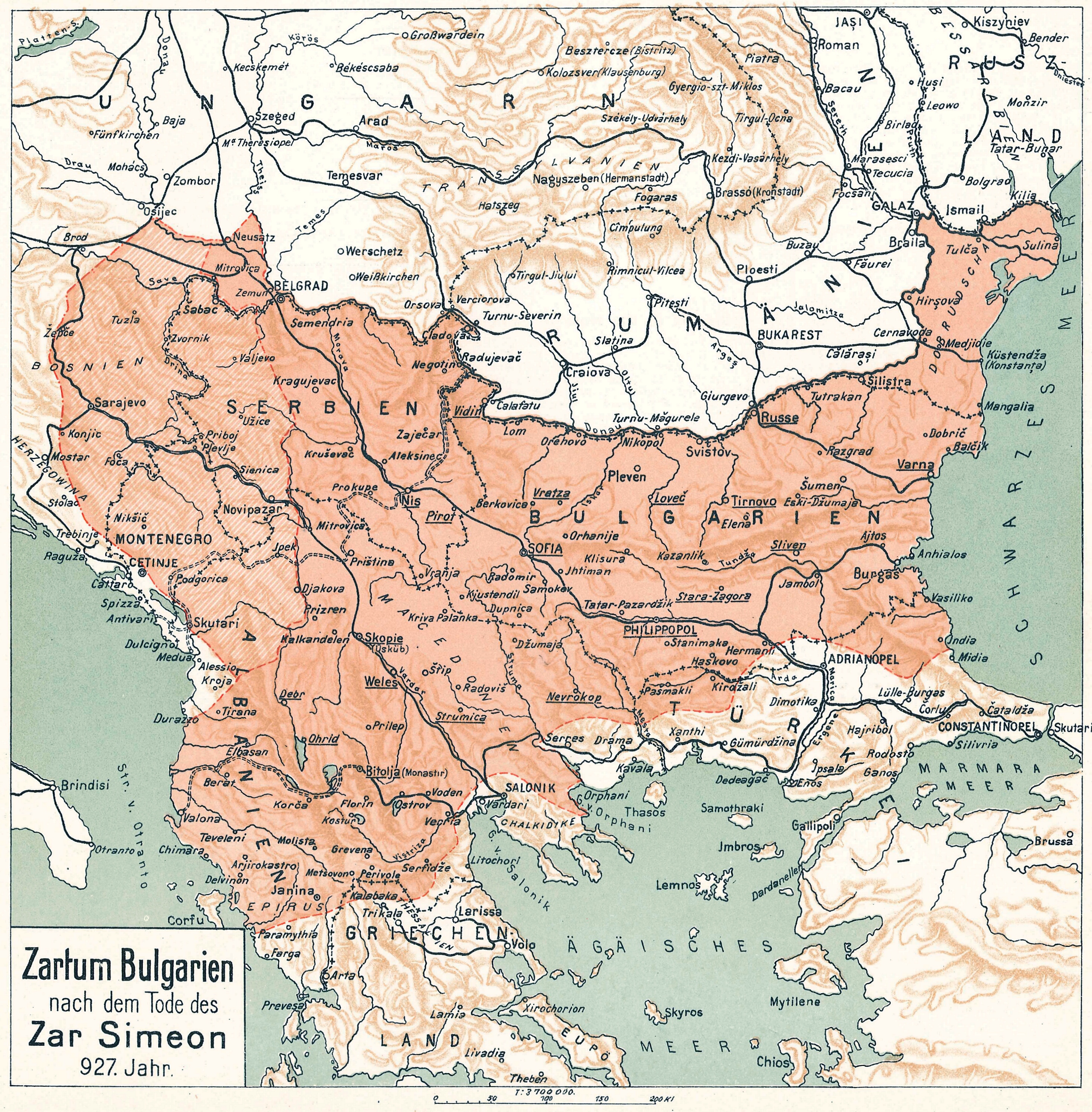
Tsar Simeon (also Symeon) I the Great ( cu, цѣсар҄ь Сѷмеѡ́нъ А҃ Вели́къ, cěsarĭ Sỳmeonŭ prĭvŭ Velikŭ bg, цар Симеон I Велики, Simeon I Veliki el, Συμεών Αʹ ὁ Μέγας, Sumeṓn prôtos ho Mégas) ruled over Bulgaria from 893 to 927,Lalkov, ''Rulers of Bulgaria'', pp. 23–25. during the First Bulgarian Empire. Simeon's successful campaigns against the Byzantines, Magyars and Serbs led Bulgaria to its greatest territorial expansion ever, making it the most powerful state in contemporary Eastern and Southeast Europe. His reign was also a period of unmatched cultural prosperity and enlightenment later deemed the Golden Age of Bulgarian culture. During Simeon's rule, Bulgaria spread over a territory between the Aegean, the Adriatic and the Black Sea.Bakalov, ''Istorija na Bǎlgarija'', "Simeon I Veliki". The newly independent Bulgarian Orthodox Church became the first new patriarchate besides the Pentarchy, and Bulgarian ... [...More Info...] [...Related Items...] OR: [Wikipedia] [Google] [Baidu] |
Antarctic Place-names Commission
The Antarctic Place-names Commission was established by the Bulgarian Antarctic Institute in 1994, and since 2001 has been a body affiliated with the Ministry of Foreign Affairs of Bulgaria. The Commission approves Bulgarian place names in Antarctica, which are formally given by the President of the Republic according to the Bulgarian Constitution (Art. 98) and the established international practice. Bulgarian names in Antarctica Geographical names in Antarctica reflect the history and practice of Antarctic exploration. The nations involved in Antarctic research give new names to nameless geographical features for the purposes of orientation, logistics, and international scientific cooperation. As of 2021, there are some 20,091 named Antarctic geographical features, including 1,601 features with names given by Bulgaria.Bulgarian Antarctic Gazett ... [...More Info...] [...Related Items...] OR: [Wikipedia] [Google] [Baidu] |
Composite Gazetteer Of Antarctica
The Composite Gazetteer of Antarctica (CGA) of the Scientific Committee on Antarctic Research (SCAR) is the authoritative international gazetteer containing all Antarctic toponyms published in national gazetteers, plus basic information about those names and the relevant geographical features. The Gazetteer includes also parts of the International Hydrographic Organization (IHO) General Bathymetric Chart of the Oceans (GEBCO) gazetteer for under-sea features situated south of 60° south latitude. , the overall content of the CGA amounts to 37,893 geographic names for 19,803 features including some 500 features with two or more entirely different names, contributed by the following sources: {, class="wikitable sortable" ! Country ! Names , - , United States , 13,192 , - , United Kingdom , 5,040 , - , Russia , 4,808 , - , New Zealand , 2,597 , - , Australia , 2,551 , - , Argentina , 2,545 , - , Chile , 1,866 , - , Norway , 1,706 , - , Bulgaria , 1,450 , - , Ge ... [...More Info...] [...Related Items...] OR: [Wikipedia] [Google] [Baidu] |
United Kingdom
The United Kingdom of Great Britain and Northern Ireland, commonly known as the United Kingdom (UK) or Britain, is a country in Europe, off the north-western coast of the continental mainland. It comprises England, Scotland, Wales and Northern Ireland. The United Kingdom includes the island of Great Britain, the north-eastern part of the island of Ireland, and many smaller islands within the British Isles. Northern Ireland shares a land border with the Republic of Ireland; otherwise, the United Kingdom is surrounded by the Atlantic Ocean, the North Sea, the English Channel, the Celtic Sea and the Irish Sea. The total area of the United Kingdom is , with an estimated 2020 population of more than 67 million people. The United Kingdom has evolved from a series of annexations, unions and separations of constituent countries over several hundred years. The Treaty of Union between the Kingdom of England (which included Wales, annexed in 1542) and the Kingdom of Scotland in 170 ... [...More Info...] [...Related Items...] OR: [Wikipedia] [Google] [Baidu] |
Ficheto Point
Ficheto Point (Nos Ficheto 'nos 'fi-che-to) is an ice-free point on the northeast coast of Varna Peninsula, Livingston Island, Antarctica forming the southeast side of the entrance to Dragon Cove. ''Channel Rock'' () is lying in the adjacent northwestern part of McFarlane Strait, northeast of Ficheto Point and south-southwest of Meade Islands. The area was visited by 19th century sealers. The point is named after the famous Bulgarian architect, builder and sculptor Nikola Fichev – ‘Kolyu Ficheto’ (1800-1881). Channel Rock was charted and descriptively named by the Discovery Investigations in 1935. Location Ficheto Point is located at which is southeast of Williams Point, east-southeast of Sigritsa Point, east of Sayer Nunatak and northwest of Pomorie Point. (British mapping in 1935 and 1968, Bulgarian in 2005 and 2009). See also * Composite Antarctic Gazetteer * List of Antarctic islands south of 60° S * SCAR * Territorial claims in Antarctica Maps * L.L ... [...More Info...] [...Related Items...] OR: [Wikipedia] [Google] [Baidu] |
Sayer Nunatak
Sayer Nunatak is a rocky peak rising to 210 m south of Williams Point on Varna Peninsula, at the north edge of the ice cap of Livingston Island in the South Shetland Islands, Antarctica. The nunatak is forming the north extremity of Vidin Heights and surmounting Dragon Cove to the northeast, Griffin Cove to the north-northwest and Charybdis Cove to the southwest. The feature is named after the American Captain Sayer, Master of the brig ''General Scott'', who carried out sealing operations in this area in 1821–22. Location The peak is located at which is 2.3 km south of Williams Point, 3.8 km west-northwest of Pomorie Point, 5.92 km north-northwest of Rakovski Nunatak, 2.2 km north of Zhelyava Hill, 7.18 km north by east of Miziya Peak and 4.9 km northeast of Kotis Point (British mapping in 1968, Spanish in 1991, and Bulgarian in 2005 and 2009). See also * Vidin Heights * Varna Peninsula * Livingston Island Maps * L.L. Ivanov et al. Antarctic ... [...More Info...] [...Related Items...] OR: [Wikipedia] [Google] [Baidu] |
Williams Point
Williams Point is the point forming both the north extremity of Varna Peninsula and the northeast tip of Livingston Island in the South Shetland Islands, Antarctica. Separated from Zed Islands to the north by Iglika Passage. The discovery of the South Shetland Islands was first reported in 1819 by William Smith, Master of the brig ''Williams'' who had sighted the point on 19 February that year. An 1820 publication suggests that Smith gave the name ‘Williams’ to a point of land in this vicinity. In recent years the place name Williams Point has been established in international usage for the point described. Location The point is located at which is 9.47 km north of Miziya Peak in Vidin Heights, 8.8 km east of Desolation Island, 1.5 km south of Zed Islands and 5.5 km west of Duff Point on Greenwich Island. British mapping in 1822, Chilean in 1971, Argentine in 1980, Spanish in 1991, and Bulgarian in 2005 and 2009. Maps Chart of South Shetland inc ... [...More Info...] [...Related Items...] OR: [Wikipedia] [Google] [Baidu] |
Bulgaria
Bulgaria (; bg, България, Bǎlgariya), officially the Republic of Bulgaria,, ) is a country in Southeast Europe. It is situated on the eastern flank of the Balkans, and is bordered by Romania to the north, Serbia and North Macedonia to the west, Greece and Turkey to the south, and the Black Sea to the east. Bulgaria covers a territory of , and is the sixteenth-largest country in Europe. Sofia is the nation's capital and largest city; other major cities are Plovdiv, Varna and Burgas. One of the earliest societies in the lands of modern-day Bulgaria was the Neolithic Karanovo culture, which dates back to 6,500 BC. In the 6th to 3rd century BC the region was a battleground for ancient Thracians, Persians, Celts and Macedonians; stability came when the Roman Empire conquered the region in AD 45. After the Roman state splintered, tribal invasions in the region resumed. Around the 6th century, these territories were settled by the early Slavs. The Bulgars, led by Asp ... [...More Info...] [...Related Items...] OR: [Wikipedia] [Google] [Baidu] |
Viceroy
A viceroy () is an official who reigns over a polity in the name of and as the representative of the monarch of the territory. The term derives from the Latin prefix ''vice-'', meaning "in the place of" and the French word ''roy'', meaning "king". He has also been styled the king's lieutenant. A viceroy's territory may be called a viceroyalty, though this term is not always applied. The adjective form is ''viceregal'', less often ''viceroyal''. The term ''vicereine'' is sometimes used to indicate a female viceroy ''suo jure'', although ''viceroy'' can serve as a gender-neutral term. Vicereine is more commonly used to indicate a viceroy's wife. The term has occasionally been applied to the governors-general of the Commonwealth realms, who are ''viceregal'' representatives of the monarch. ''Viceroy'' is a form of royal appointment rather than noble rank. An individual viceroy often also held a noble title, however, such as Bernardo de Gálvez, 1st Viscount of Galveston, who was ... [...More Info...] [...Related Items...] OR: [Wikipedia] [Google] [Baidu] |


