|
Siddipet District
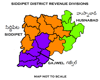
Siddipet district is a district located in the northern region of the Indian state of Telangana. Its headquarters is Siddipet. This district contains a part of the Hyderabad Metropolitan Region( Markook Mulugu Wargal) The district shares boundaries with Jangaon, Sircilla, Karimnagar, Kamareddy, Hanamkonda, Yadadri, Medhchal and Medak districts. Geography This district is bounded by Rajanna Sircilla district in the north, Karimnagar district in the northeast, Jangaon district in the east, Yadadri Bhuvanagiri district in the south, Medchal district in the southwest, Medak district in the west and Kamareddy district in the northwest. District administration The collector of Siddipet district is M. Hanmantha Rao, appointed on 16 November 2021, succeeding P. Venkatrami Reddy, who submitted his resignation to join politics. Administrative divisions The district will have three revenue divisions of Gajwel, Siddipet and Husnabad Husnabad is a town in the ... [...More Info...] [...Related Items...] OR: [Wikipedia] [Google] [Baidu] |
Districts Of Telangana
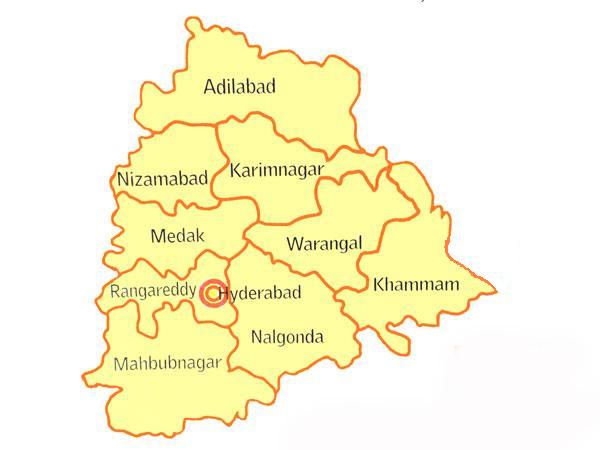
The Indian state of Telangana has 33 districts, each headed by a District collector. History Telangana region of Hyderabad State consisted of 8 Districts in 1948 when it was inducted in Dominion of India; they are Hyderabad, Mahbubnagar, Medak, Nalgonda, Nizamabad, Adilabad, Karimnagar and Warangal districts. Khammam district was created by bifurcation of Warangal district on 1 October 1953. Andhra Pradesh was formed by merging Telangana region of Hyderabad State and Andhra state on 1 November 1956. Bhadrachalam division and Aswaraopet taluka parts was merged in Khammam district from Godavari districts for better Administration. Hyderabad district was split into Hyderabad Urban District and Hyderabad Rural District on 15 August 1978. Hyderabad Urban District was made by 4 Talukas are Charminar, Golkonda, Mushirabad and Secunderabad Talukas which consist of only MCH area, Secunderabad cantonment and Osmania University. Hyderabad rural district was later renamed as Ranga ... [...More Info...] [...Related Items...] OR: [Wikipedia] [Google] [Baidu] |
Sircilla District
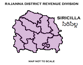
Rajanna Sircilla district is a district in the Indian state of Telangana. Sircilla is the district headquarters. The district shares boundaries with Karimnagar, Siddipet, Jagtial, Kamareddy, and Nizamabad districts. Geography The district is spread over an area of . This district is bounded by Jagtial District in the North, Karimnagar District in the North East, Siddipet District in the South, Kamareddy District in the West and Nizamabad District in the North West. Demographics Census of India, the district has a population of 546,121. This district has a literacy rate 62.71%. Administrative divisions The district will have two revenue division of Sircilla and Vemulawada It is sub-divided into 13 mandals. D. Krishna Bhaskar is the present collector of the district. See also * List of districts in Telangana The Indian state of Telangana has 33 districts, each headed by a District collector. History Telangana region of Hyderabad State consisted of 8 ... [...More Info...] [...Related Items...] OR: [Wikipedia] [Google] [Baidu] |
List Of Districts In Telangana
The Indian state of Telangana has 33 districts, each headed by a District collector. History Telangana region of Hyderabad State consisted of 8 Districts in 1948 when it was inducted in Dominion of India; they are Hyderabad, Mahbubnagar, Medak, Nalgonda, Nizamabad, Adilabad, Karimnagar and Warangal districts. Khammam district was created by bifurcation of Warangal district on 1 October 1953. Andhra Pradesh was formed by merging Telangana region of Hyderabad State and Andhra state on 1 November 1956. Bhadrachalam division and Aswaraopet taluka parts was merged in Khammam district from Godavari districts for better Administration. Hyderabad district was split into Hyderabad Urban District and Hyderabad Rural District on 15 August 1978. Hyderabad Urban District was made by 4 Talukas are Charminar, Golkonda, Mushirabad and Secunderabad Talukas which consist of only MCH area, Secunderabad cantonment and Osmania University. Hyderabad rural district was later renamed as Ran ... [...More Info...] [...Related Items...] OR: [Wikipedia] [Google] [Baidu] |
Husnabad
Husnabad is a town in the Siddipet district of the Indian state of Telangana. It was a part of Karimnagar district before re-organisation of districts in the state. It is located in Husnabad mandal. Geography It is a mandal headquarters of Husnabad mandal in Siddipet district. Husnabad is situated partly on line of hills which passes through the town from South-west to North-east. Yellama Cheruvu is on the south side of the town. Husnabad is from Karimnagar, from Siddipet, from Warangal and 135 km from Hyderabad Hyderabad ( ; , ) is the capital and largest city of the Indian state of Telangana and the ''de jure'' capital of Andhra Pradesh. It occupies on the Deccan Plateau along the banks of the Musi River, in the northern part of Southern India .... History The town of Husnabad was part of Karimnagar district in the state of Hyderabad state from 1948 to 1956. Then it became part of Andhra Pradesh state till 2014 and later on June 2, 2014 It became part ... [...More Info...] [...Related Items...] OR: [Wikipedia] [Google] [Baidu] |
Gajwel
Gajwel, officially Gajwel–Pragnapur, is a town and a municipality in Siddipet district of the Indian state of Telangana. Gajwel–Pragnapur Nagar Panchayat was constituted in 2012. The jurisdiction of the civic body is spread over an area of . Gajwel is about 53 km from Hyderabad on the Rajiv highway. It is one of the fastest-developing town in Telangana. Awards Gajwel has been awarded for theBest Clean City Award in a municipality category of 20 to 50 population category. Geography Gajwel is located at 17.8517°N 78.6828°E. It has an average elevation of 568 meters (1866 ft) above sea level. Gajwel is about 53km from Secundrerabad on the Rajiv highway. The nearest airport is Rajiv Gandhi International Airport in the Telangana capital city, Hyderabad. Administration Till 2012 Gajwel was a Panchayat and in the year 2012 it was upgraded as Nagara Panchayat vide G.O. No.34, dated: 251-01-2012, duly merging surrounding three (3) Gram panchayats i.e., 1. Pragnapur, 2. Mutraj ... [...More Info...] [...Related Items...] OR: [Wikipedia] [Google] [Baidu] |
List Of Revenue Divisions In Telangana
Revenue Divisions are the administrative divisions in districts of some of the Indian states. These divisions are sub-divided into mandals. There are 71 revenue divisions in Telangana Telangana (; , ) is a state in India situated on the south-central stretch of the Indian peninsula on the high Deccan Plateau. It is the eleventh-largest state and the twelfth-most populated state in India with a geographical area of and 3 .... Revenue Divisional Officer (RDO) is the head of the division. List of revenue divisions There are a total of 72 revenue divisions in the state. The below table details the revenue divisions with respect to their districts. See also * List of districts in Telangana References External links {{DEFAULTSORT:Revenue divisions in Telangana Telangana-related lists ... [...More Info...] [...Related Items...] OR: [Wikipedia] [Google] [Baidu] |
Medchal-Malkajgiri District
Medchal−Malkajgiri district is a district in the Indian state of Telangana. Shamirpet is the headquarter of the district. It is the second most populous district with a population of 25 lakh and also 91.40% urbanized district in the state of Telangana, standing next only to Hyderabad district which has a population of 40 lakhs. The district shares boundaries with Hyderabad, Medak, Sangareddy, Y. Bhuvanagiri, Siddipet and Rangareddy districts.The most part of the district consist of Hyderabad City (GHMC) Geography The district is spread over an area of .It is situated 505 metres above sea level. The landmark consists of rocky terrain and monolithic rocks in the outskirts of the city. Demographics census of India, the district is the second most populous district in the state with a population of 2,440,073. Administrative divisions The district will have two revenue divisions of Keesara and Malkajgiri. They are sub-divided into 15 mandals. Sri V. Venkateswarlu, IAS ... [...More Info...] [...Related Items...] OR: [Wikipedia] [Google] [Baidu] |
Yadadri Bhuvanagiri
Yadadri Bhuvanagiri District, is a district in the Indian state of Telangana. The administrative headquarters is located at Bhuvanagiri Town. The district shares boundaries with Suryapet, Nalgonda, Jangaon, Siddipet, Medchal-Malkajgiri and Rangareddy districts. It was carved out of Nalgonda district on 11 October 2016 during a large reorganization of the districts of Telangana. Geography The district is spread over an area of . Demographics Census of India, the district has a population of 726,465. According to the 2011 census, 90.54% of the district speaks Telugu, 4.97% Lambadi and 3.42% Urdu. Major Towns * Bhuvanagiri *Choutuppal *Alair *Mothkur Notable places in District *Bhuvanagiri Fort in Bhuvanagiri *Kolanupaka Temple in Alair - 33 km from Bhuvanagiri *Kunda Sathyanarayana Kala Dhamam-13 km from Bhuvanagiri *Yadagirigutta temple -16 km from Bhuvanagiri *Ramaneswaram temple in Nagireddypally-15 km from Bhuvanagiri Administrati ... [...More Info...] [...Related Items...] OR: [Wikipedia] [Google] [Baidu] |
Rajanna Sircilla District
Rajanna Sircilla district is a district in the Indian state of Telangana. Sircilla is the district headquarters. The district shares boundaries with Karimnagar, Siddipet, Jagtial, Kamareddy, and Nizamabad districts. Geography The district is spread over an area of . This district is bounded by Jagtial District in the North, Karimnagar District in the North East, Siddipet District in the South, Kamareddy District in the West and Nizamabad District in the North West. Demographics Census of India, the district has a population of 546,121. This district has a literacy rate 62.71%. Administrative divisions The district will have two revenue division of Sircilla and Vemulawada It is sub-divided into 13 mandals. D. Krishna Bhaskar is the present collector of the district. See also * List of districts in Telangana The Indian state of Telangana has 33 districts, each headed by a District collector. History Telangana region of Hyderabad State consisted of 8 Dist ... [...More Info...] [...Related Items...] OR: [Wikipedia] [Google] [Baidu] |
Medak District
Medak district is a district located in the Indian state of Telangana. Medak is the district headquarters. The district shares boundaries with Sangareddy, Kamareddy, Siddipet and Medchal districts. History Traces of Neolithic and Megalithic culture was found at Edithanur and Wargal village hillocks in the district. Rock paintings were found at Edithanur boulders and Hastallapur rocks. Nizam state In 20th century Medak district was a part of Nizam princely State before independence and merged into Hyderabad State in Independent India and presently a district of Telangana. Qutub Shahis named it as Gulshanabad which means '"city of gardens'" due to its luscious greenery. Geography The district is spread over an area of . Demographics As of the 2011 Census of India, the district has a population of 767,428. Economy In 2006 the Indian government named Medak one of the country's 250 most backward districts (out of a total of 640). It is one of the thirteen districts ... [...More Info...] [...Related Items...] OR: [Wikipedia] [Google] [Baidu] |
Medchal District
Medchal−Malkajgiri district is a district in the Indian state of Telangana. Shamirpet is the headquarter of the district. It is the second most populous district with a population of 25 lakh and also 91.40% urbanized district in the state of Telangana, standing next only to Hyderabad district which has a population of 40 lakhs. The district shares boundaries with Hyderabad, Medak, Sangareddy, Y. Bhuvanagiri, Siddipet and Rangareddy districts.The most part of the district consist of Hyderabad City (GHMC) Geography The district is spread over an area of .It is situated 505 metres above sea level. The landmark consists of rocky terrain and monolithic rocks in the outskirts of the city. Demographics census of India, the district is the second most populous district in the state with a population of 2,440,073. Administrative divisions The district will have two revenue divisions of Keesara and Malkajgiri. They are sub-divided into 15 mandals. Sri V. Venkateswarlu, IAS ... [...More Info...] [...Related Items...] OR: [Wikipedia] [Google] [Baidu] |
Yadadri Bhuvanagiri District
Yadadri Bhuvanagiri District, is a district in the Indian state of Telangana. The administrative headquarters is located at Bhuvanagiri Town. The district shares boundaries with Suryapet, Nalgonda, Jangaon, Siddipet, Medchal-Malkajgiri and Rangareddy districts. It was carved out of Nalgonda district on 11 October 2016 during a large reorganization of the districts of Telangana. Geography The district is spread over an area of . Demographics Census of India, the district has a population of 726,465. According to the 2011 census, 90.54% of the district speaks Telugu, 4.97% Lambadi and 3.42% Urdu. Major Towns * Bhuvanagiri *Choutuppal *Alair *Mothkur Notable places in District *Bhuvanagiri Fort in Bhuvanagiri *Kolanupaka Temple in Alair - 33 km from Bhuvanagiri *Kunda Sathyanarayana Kala Dhamam-13 km from Bhuvanagiri *Yadagirigutta temple -16 km from Bhuvanagiri *Ramaneswaram temple in Nagireddypally-15 km from Bhuvanagiri Administrative ... [...More Info...] [...Related Items...] OR: [Wikipedia] [Google] [Baidu] |


