|
Ship And Boat Building In Whitby
Ship and boat building in Whitby was a staple part of the industry of Whitby, North Yorkshire, England between the 17th and 19th centuries. In 1792 and 1793, Whitby was the second largest ship-building port in England and Wales. Building continued throughout the 20th century but on a smaller scale both in terms of output and overall size of the vessels being built. The position of the town, being geographically hard to reach due to the surrounding moorland, meant that until the coming of the railways, the town was largely reliant on the sea for imports and trade. Whitby was a safe haven from storms in the North Sea and was also a useful stop-off point for the resupply of ships. Given Whitby's status as a whaling port, and supply port, it developed a burgeoning ship and boat-building business that ranged from ocean-going barques, to small fishing cobles. One builder still exists in the town, Parkol Marine, which up to 2019, had constructed over 40 trawlers and other ships, mainly ... [...More Info...] [...Related Items...] OR: [Wikipedia] [Google] [Baidu] |
Yorkshire Coast
The Yorkshire Coast runs from the Tees estuary to the Humber estuary, on the east coast of England. The cliffs at Boulby are the highest on the east coast of England, rising to above the sea level. The North York Moors National Park extends up to the coastline and traverses of it between Boulby and Cloughton, taking in the historic fishing villages of Staithes, Runswick Bay and Robin Hood's Bay. The section of coastline south of Bridlington to Spurn Head is also known as the Holderness coast, from the area of East Yorkshire it adjoins. In 2016, Natural England announced the creation of a coastal path between Filey Brigg and Newport (Middlesbrough) Transporter Bridge. This will eventually link up with paths all around the coastline of England to become the England Coast Path. The section from Filey to Saltburn is in use as part of the Cleveland Way. The coastline between the two estuaries was historically made up of the East and North Ridings of Yorkshire. From 1974 to ... [...More Info...] [...Related Items...] OR: [Wikipedia] [Google] [Baidu] |
Liverpool
Liverpool is a city and metropolitan borough in Merseyside, England. With a population of in 2019, it is the 10th largest English district by population and its metropolitan area is the fifth largest in the United Kingdom, with a population of 2.24 million. On the eastern side of the Mersey Estuary, Liverpool historically lay within the ancient hundred of West Derby in the county of Lancashire. It became a borough in 1207, a city in 1880, and a county borough independent of the newly-created Lancashire County Council in 1889. Its growth as a major port was paralleled by the expansion of the city throughout the Industrial Revolution. Along with general cargo, freight, and raw materials such as coal and cotton, merchants were involved in the slave trade. In the 19th century, Liverpool was a major port of departure for English and Irish emigrants to North America. It was also home to both the Cunard and White Star Lines, and was the port of registry of the ocean lin ... [...More Info...] [...Related Items...] OR: [Wikipedia] [Google] [Baidu] |
Kingston Upon Hull
Kingston upon Hull, usually abbreviated to Hull, is a port city and unitary authority in the East Riding of Yorkshire, England. It lies upon the River Hull at its confluence with the Humber Estuary, inland from the North Sea and south-east of York, the historic county town. With a population of (), it is the fourth-largest city in the Yorkshire and the Humber region after Leeds, Sheffield and Bradford. The town of Wyke on Hull was founded late in the 12th century by the monks of Meaux Abbey as a port from which to export their wool. Renamed ''Kings-town upon Hull'' in 1299, Hull had been a market town, military supply port, trading centre, fishing and whaling centre and industrial metropolis. Hull was an early theatre of battle in the English Civil Wars. Its 18th-century Member of Parliament, William Wilberforce, took a prominent part in the abolition of the slave trade in Britain. More than 95% of the city was damaged or destroyed in the blitz and suffere ... [...More Info...] [...Related Items...] OR: [Wikipedia] [Google] [Baidu] |
The Principal Shipyards In Whitby
''The'' () is a grammatical article in English, denoting persons or things already mentioned, under discussion, implied or otherwise presumed familiar to listeners, readers, or speakers. It is the definite article in English. ''The'' is the most frequently used word in the English language; studies and analyses of texts have found it to account for seven percent of all printed English-language words. It is derived from gendered articles in Old English which combined in Middle English and now has a single form used with pronouns of any gender. The word can be used with both singular and plural nouns, and with a noun that starts with any letter. This is different from many other languages, which have different forms of the definite article for different genders or numbers. Pronunciation In most dialects, "the" is pronounced as (with the voiced dental fricative followed by a schwa) when followed by a consonant sound, and as (homophone of pronoun '' thee'') when followed by a ... [...More Info...] [...Related Items...] OR: [Wikipedia] [Google] [Baidu] |
A169 Road
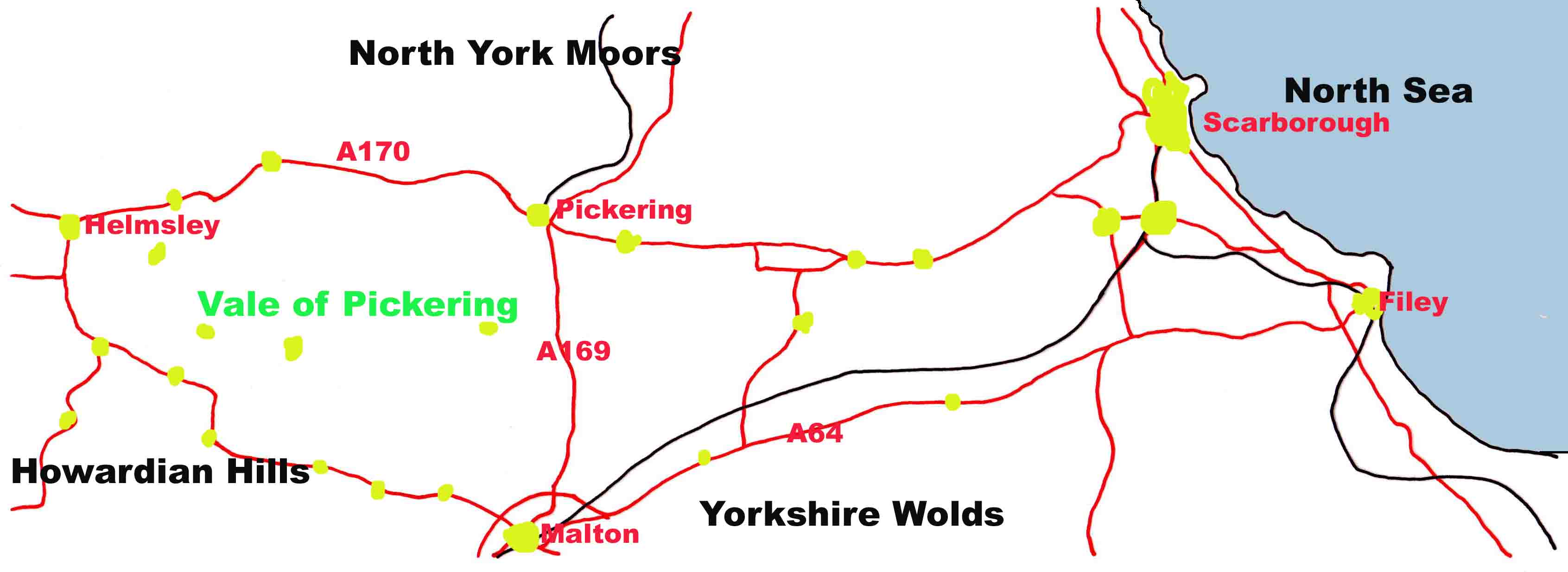
The A169 is an A road in North Yorkshire, England. It runs from the A64 at Malton on the edge of the Yorkshire Wolds through the Vale of Pickering and across the North York Moors to join the A171 just west of Whitby. It is a single carriageway for all of its route. Whilst it is not considered a Primary Route nationally, the Ryedale Local Transport Plan lists it as part of its Major Road Network alongside the A64, A166 and A171. The moorland section between Pickering and the junction with the A171 can be problematic to travellers during winter when frost, dense fog and heavy snow are common occurrences. Settlements on the road * Malton * Pickering * Lockton * Saltergate * Sleights * (Whitby) Route The B1257 connects Malton town centre with the A64. Once the B1257 reaches the A64 it becomes the A169 road to Whitby. On the north west of this junction is Eden Camp. The route then goes in a mainly northerly direction through the Vale of Pickering and crossing th ... [...More Info...] [...Related Items...] OR: [Wikipedia] [Google] [Baidu] |
Lockton
Lockton is a small village and civil parish in the Ryedale district of North Yorkshire, England. It is situated in the North York Moors about north-east of Pickering. Nearby villages include Newton-on-Rawcliffe and Levisham. The village is often used as a base by tourists visiting the nearby Dalby Forest. The village is mentioned in the Domesday Book as ''Lochetun'', which is believed to have derived from the Old English of ''loca tūn'', meaning the enclosure of Loca's people. According to the 2001 UK census, Lockton parish had a population of 265, increasing to 332 at the 2011 Census. The population tally includes that of nearby Levisham; about 200 people live in Lockton. The Church of St Giles dates back to the 13th century (nave and chancel) with a 15th-century tower. The structure is now grade II* listed. In 1961, a Royal Observer Corps The Royal Observer Corps (ROC) was a civil defence organisation intended for the visual detection, identification, tracking ... [...More Info...] [...Related Items...] OR: [Wikipedia] [Google] [Baidu] |
Vale Of Pickering
The Vale of Pickering is a low-lying flat area of land in North Yorkshire, England. It is drained by the River Derwent. The landscape is rural with scattered villages and small market towns. It has been inhabited continuously from the Mesolithic period. The present economy is largely agricultural with light industry and tourism playing an increasing role. Location and transport The Vale of Pickering is a low-lying plain, orientated in an east–west direction. It is well defined by the Yorkshire Wolds escarpment to the south, the Corallian limestone foothills of the North York Moors to the north, the North Sea coast to the east and the Howardian Hills to the west. The east–west-orientated main roads ( A64 and A170) in the vale follow the shoreline of the glacial lake, which formed in the vale after the last ice age. The main A169 road crosses the vale in a north–south direction, joining the market towns of Malton and Pickering. At the eastern edge of the vale the A165 ... [...More Info...] [...Related Items...] OR: [Wikipedia] [Google] [Baidu] |
Gulf Of Riga
The Gulf of Riga, Bay of Riga, or Gulf of Livonia ( lv, Rīgas līcis, et, Liivi laht) is a bay of the Baltic Sea between Latvia and Estonia. The island of Saaremaa (Estonia) partially separates it from the rest of the Baltic Sea. The main connection between the gulf and the Baltic Sea is the Irbe Strait. The Gulf of Riga, as a sub-basin of the Baltic, also includes the Väinameri Sea in the West Estonian archipelago. Geography Extent The International Hydrographic Organization defines the Gulf of Riga's western limit as "A line running from Lyser Ort (57°34'N), in Latvia, to the South extreme of Œsel Island, through this island to Pammerort (22°34'E), thence to Enmast Point, the S extreme of Dagö, through Dagö to Takhkona Point, the North extreme thereof, and on to Spithamn Point in Estonia". Islands Major islands in the gulf include Saaremaa, Kihnu, and Ruhnu, which are all controlled by Estonia. Kihnu covers an area of . Saaremaa island is responsi ... [...More Info...] [...Related Items...] OR: [Wikipedia] [Google] [Baidu] |
Baltic States
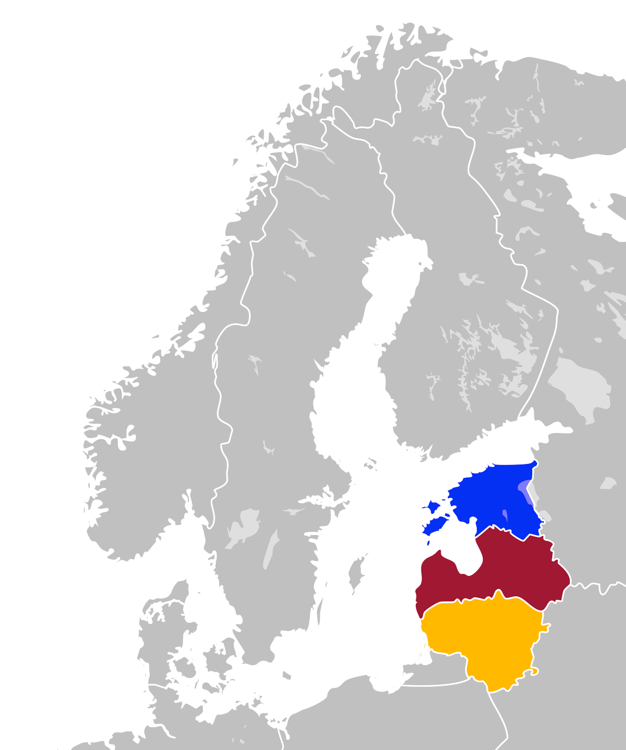
The Baltic states, et, Balti riigid or the Baltic countries is a geopolitical term, which currently is used to group three countries: Estonia, Latvia, and Lithuania. All three countries are members of NATO, the European Union, the Eurozone, and the OECD. The three sovereign states on the eastern coast of the Baltic Sea are sometimes referred to as the "Baltic nations", less often and in historical circumstances also as the "Baltic republics", the "Baltic lands", or simply the Baltics. All three Baltic countries are classified as high-income economies by the World Bank and maintain a very high Human Development Index. The three governments engage in intergovernmental and parliamentary cooperation. There is also frequent cooperation in foreign and security policy, defence, energy, and transportation. The term "Baltic states" ("countries", "nations", or similar) cannot be used unambiguously in the context of cultural areas, national identity, or language. While the majorit ... [...More Info...] [...Related Items...] OR: [Wikipedia] [Google] [Baidu] |
First World War
World War I (28 July 1914 11 November 1918), often abbreviated as WWI, was one of the deadliest global conflicts in history. Belligerents included much of Europe, the Russian Empire, the United States, and the Ottoman Empire, with fighting occurring throughout Europe, the Middle East, Africa, the Pacific, and parts of Asia. An estimated 9 million soldiers were killed in combat, plus another 23 million wounded, while 5 million civilians died as a result of military action, hunger, and disease. Millions more died in genocides within the Ottoman Empire and in the 1918 influenza pandemic, which was exacerbated by the movement of combatants during the war. Prior to 1914, the European great powers were divided between the Triple Entente (comprising France, Russia, and Britain) and the Triple Alliance (containing Germany, Austria-Hungary, and Italy). Tensions in the Balkans came to a head on 28 June 1914, following the assassination of Archduke Franz Ferdi ... [...More Info...] [...Related Items...] OR: [Wikipedia] [Google] [Baidu] |
Ropery
A ropewalk is a long straight narrow lane, or a covered pathway, where long strands of material are laid before being twisted into rope. Due to the length of some ropewalks, workers may use bicycles to get from one end to the other. Many ropewalks were in the open air, while others were covered only by roofs. Ropewalks historically were harsh sweatshops, and frequently caught fire, as hemp dust ignites easily and burns fiercely. Rope was essential in sailing ships and the standard length for a British Naval Rope was . A sailing ship such as required of rope. Rope-making technology Natural fibres are short in length, and so have to be twisted together into different fibres, starting at different points along the construction, to hold each other together. From a single strand, much like wool, which can easily be torn apart, putting several together forms a line, which is far stronger. That can similarly be repeated time and again, producing a very strong rope, at the cost of ... [...More Info...] [...Related Items...] OR: [Wikipedia] [Google] [Baidu] |


.png)


